

To ZOOM in on a desktop computer – hold CONTROL and + (on mac COMMAND and +)
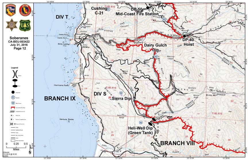
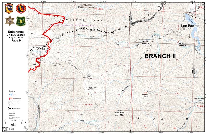
Operations Map
Legend

Public Information Map

Infrared Topo

Infrared with Satelite Image

Infrared Log
Weather Forcast
Fire Behavior Forcast
Dozer Index

Dozer Maps


Notes:
-Read more about the satellite heat detection here: xasauan today
-Adam Clark has provided an updated link for people to use if they don’t have Google Earth. You can find it here: Mapping Support (Black lines are completed Dozer lines and Blue lines are proposed Dozer lines, but they may not be current. Go to the Dozer maps for the most current info.)
-The weather information for the “blue WX rectangles” can be located at: MesoWest (link provided by Larry)
Scroll down to SC07 Central Coast. There are 6 IRAWS which stands for Incident Remote Automated Weather Stations. Each are labeled with a number and location. This page is a summary (refresh the page to get the latest observations) but there are hyperlinks to each station for more detailed information. UTC/GMT time zone is 7 hours ahead.
-Live Air Traffic can be found here: Flight Radar 24
Thank you, Lucas, you are amazing!
Thank you, all again for the time and effort for these wonderful maps! So much comfort in being able to see a snapshot, into the unknown. A light in the dark! The smoke had been so thick for many days giving an uneasy feeling not knowing where or how close it really was…seeing these daily maps and links to others are a Blessing! Thank you, Kate, thank you all for sharing your talents and gifts with us!
Good Morning Lucas. Thanks for the maps. Can you tell me where we can read the up-to-date weather info from the ‘blue WX rectangles’ (portable weather stations) on the map? During meet at CMS last Thursday, the spokesman for these WX stations did refer to a website for them, but I did not jot it down. It would be useful to get that info. Thanks.
The weather information for the “blue WX rectangles” can be located at: http://mesowest.utah.edu/cgi-bin/droman/raws_ca_monitor.cgi?rawsflag=1&state=SOCC&type=0&orderby=n&day1=31&month1=7&year1=2016&hour1=14&refrsh=0&timeobs=12
Scroll down to SC07 Central Coast. There are 6 IRAWS which stands for Incident Remote Automated Weather Stations. Each are labeled with a number and location. This page is a summary (refresh the page to get the latest observations) but there are hyperlinks to each station for more detailed information. Hope this helps.
Thank you, Larry! I’ll include your link in the post.
We just moved into this area earlier this year. Under the unfortunate circumstances, we were lucky to discover this blog site. We don’t know the people behind this tireless effort, but are in deep gratitude for the valuable and timely dissemination of information you provide us.
Great work, Lucas. Studying these detailed maps, in conjunction with Kodiak Greenwood’s photos, and Keith Vandervere’s descriptions are unbelieably helpful. I have learned more about the geography of this area in the last 10 days than I learned in 32 years
Wow! Great maps. The infrareds show the most accuracy around pico blanco ( or pico blacko). From clear ridge we watched the fire surround the mountain and work it’s way down the south side yesterday and last night.
Living near Seattle on an island, I feel out of touch with my home and roots there on the Monterey Peninsula and Big Sur where my daughter, Laura lives. This website is the very most information one can get from this distance, and it is vital to us who need to know how family and friends are surviving this fire. Thank you so much, great effort.
I agree! I’ve learned so much more about the back country geography. Thank you for all of your timely information, Kate!
Does anyone know how hot (ºF) this fire is burning?
Stay safe, one and all!
Thanks so much for the detailed maps. Is there a way to publish a blow-up of the legends on the maps? I don’t know what all the icons on the maps mean, and the pixel size on the map reproductions in the blog do not allow me to be able to read them if I expand the image, at least on my Mac computer.
Stepped outside just now and can smell the smoke this morning. The deep marine layer is capturing it today. I am in Royal Oaks, just south of Watsonville. Thank you Kate and others who are keeping us informed of
our precious Big Sur treasure.
Loren,
Please see Legend. Thanks for the recommendation!
Sharing Gayle White’s poem with all in our communities…
Fire
The fires rage across the ridgeline
Leaving the air sooty and thick.
I watch the bits of ash
Drift like dirty snow in the wind
And scatter across the ground.
Through the deep smog
Comes only shades of light –
An eerie coppery, browned orange
As if a tangerine filter was screwed on the sun
So that every bit of light turned the world
Into an gingery glow
The stripes on the flags flying at my neighbors homes
Are red and ………..orange.
The patches of light on the carpet
Below the windows are ………orange.
And sun when it can finally be seen,
At evening and morning,
Burns a frightening flaming orange.
Fire comes quickly to these parched summer hills
And greedily grows from the
The depths of the narrow valleys
Through the dry grasses
To the edges of their peaks.
It crosses ancient creeks,
And ignoring all the locked doors,
Turns homes to mere embers.
While the brave fight back
Climbing the steeps
And flying through the blighted sky
Carrying a battery of weapons
To smother the flames
And temper the intense heat.
Where below their very feet
Beneath the layers of cinders
Will push the wee sprigs, green and fresh
From the clear light of another time
That we’ve not yet begun to imagine.
That’s very beautiful ~ thank you.
Margo, that’s such a beautifully descriptive poem. Looking forward to the “clear light of another time” for all of those involved with this massive fire.
Thank you for sharing your poem with all.
Such beautiful words for such a horrendous happening. I hope one of our local newspapers sees this and shares it with all the others in our area who need your upliftinng vision.
the smoke has made it down to Los Angeles county:
http://www.signalscv.com/section/36/article/155023/
Margot, I love your poem, and how you end with new life. I also found myself needing to think ahead to HEALING and NEW LIFE in this time of death and destruction….
For anyone reading, I had this dream of planting 20,000 tree seedlings a year for three years in a row – a community effort totalling 60,000 baby trees planted by the end of 2019. Alongside that, to aid our people who have had their homes, belongings, (and many their livelihoods) devastated by the fire, I dream of pulling together as a community to raise $20 million/year over three years (similiar to the trees being planted – green money – planting new houses), totalling $60 million by the end of 2019.
There’s my dream. When I get real sad about the uncontrollable gorging of our hills by the power of fire, I think of what we can do to heal our hills, and heal our people. If we pull together, we can accomplish anything.