

Today I took a drive down coast from Crossroads to look at what could be seen from Highway 1. At Soberones Trail, near the point of origin the fire is still trying to work its way down to the highway. Engine companies are combining to pump water from the highway up to the fire burning on the south side of Soberanes Canyon. Firefighters are employing a progressive hose lay along freshly cut fire line.
There are a number of crews working together cutting line.
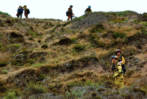
Of note is the presence of a California Conservation Corp or CCC fire crew. Since 2010 they have trained to respond to fires as Type 2 hand crews which allows them to work directly on the fire line. I watched them work up the mountain directly across the highway from Whale Peak. Below are some images of the CCC crew and other crews at the scene today.


Farther down the coast fire burning in the Little Sur River Canyon is working its way down canyon, trying to get to the highway. It has a way to go.

From Big Sur Bakery looking north you get a clear view of the dozer line painted with fire retardant that is literally a defensive line drawn of the sand. I don’t know the name of the ridge but surely locals know it on sight.

Great post, Mike. Thanks for that. The ridge across (and north) from the Big Sur Bakery is Mt. Manuel, yes, all the locals know that one.
As we all learn new parts of our land, i want to point out that the last picture is the dozer line coming down off Post Summit ( north of Mt. Manuel ) on the way towards East Molera. The Apple Pie community is to the left, below the golden hills.
Well, I stand corrected, I was trying to envision what he was seeing from the Bakery, and I confused it with Mt. Manuel. Always wanting to learn more geography. Thanks Aengus.
On the last photo… Actually that is the upper part of the Golden Stairway (aka Golden Staircase), then tuning up to Post Summit. From there the cut runs from Post Summit to the Cabezo Prieto, and then to Mt Manuel. They are putting in hand lines down from Mt Manuel in the extremely steep terrain of the Big Sur River Gorge to contect back up the the North Coast Ridge Road.
Off the top of your head, what movie was filmed at Soberanes Point? I’m old and Member of family that started Palo Colorado Canyon Assn, in 1906! Enjoy your post, Good work. Regards, Tom
Sent from my iPad
Okay, besides Keith Vandervere, Steve Harper here has an excellent knowledge of the back country and the geography of the area. I trust what he says on this explicitly.
Off the top of my head: The Sandpiper.
Wasn’t Sandpiper at Pfeiffer Beach? Maybe there, too.
Thank you so much for these posts, pictures, and comments about geography. We are all learning. I feel so thankful and blessed by these hardworking fire fighters. They are working so hard on our behalf, and on behalf of our beautiful land. Sending prayers for their safety…
Thank you for mentioning the CCC, that particular crew is from our San Diego Center.