

To give you an idea of where the Soberanes Fire is burning, we’ve included maps that are updated daily. These maps are provided by Cal Fire/US Forest Service.
The latest Heat Perimeter was detected today at 12:20 am. You can see the latest Heat Perimeter on the Infrared Topo and Infrared Ortho maps. Note: The Heat Perimeter is not current on any other Official Map.
We’ve also included the Weather Forecast, Fire Behavior Forecast and various links that you may find useful. Note: Additional links are located at the end of the post. Some links may open large PDF documents.
Please see Local Reports for the current fire discussion.
Infrared Topo: IR_Topo
Infrared with Satellite Image: IR_Ortho
IR Log
Weather Forecast
Fire Behavior Forecast
GIF animation of the fire’s southern front over the past 8 nights (provided by Dirk Reynolds):
KMZ IR flight overlaid on Google Earth (provided by John Chesnut). As always, please remember that false readings do occur.
Big Sur: Cachagua:
Operations Map North: Ops North
Operations Map South: Ops South
Legend
Briefing Map: BAM
Progression Map: Progression Map
Links:
Xasauan Today Satellite heat detection discussion
Google Maps Adam Clark’s Google Map with most recent Dozer lines, IR flight overlay, and the Planned Fire Line. Note: You may need to be signed in to a Google account to view this link.
Mapping Support Same as above, but on USGS Topo Maps
MesoWest Weather stations that are located near the fire. Scroll down to S07 Central Coast IRAWS. See the Blue WX rectangles on the Ops maps for locations. There are currently 7 portable weather stations deployed.
Flight Radar 24 Live Air Traffic for the area. Note: aircraft flying at low altitudes may not be detected.
Additional Cal Fire/ US Forest Service Links:
INCIDENT PLAN Complete Incident Plan as of 8/9/16. Note: PDF may take awhile to download
IAP MAP CARMEL Dozer Carmel as of 8/9/16
IAP MAP SECO Dozer Seco as of 8/9/16
IAP MAP SUR Dozer Sur as of 8/9/16
Air Operations Map Air Ops as of 8/7/16
Air Operations HELCO Map HELCO as of 8/6/16
Firefighting Aircraft PDF guide with Cal Fire Firefighting Aircraft
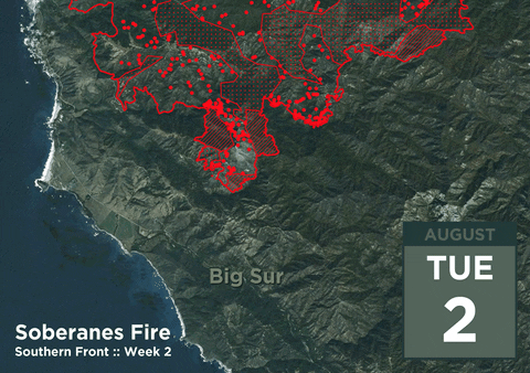
SITUATION Situation Map as of 8/2/16 shows previous fire outlines
ELEVATIONS Elevations Map as of 8/2/16 shows hills and valleys in various colors
thanks to all!
This first map more reassuring – fire line still above the house – looks like there is a little room to fight and maybe hold.
Jenny, Please see the Mapping Support link if you’d like to zoom in with more detail on the USGS Topo Map: Mapping Support
Sad that Cal Fire (and related agencies) has consistently not been able to release accurate updated maps. Most maps through this entire event have been 24 hour behind. I would hope for more. Local mapping by Keith V and others has often been more accurate while using correct place names.
Was just confirmed that on The Knoll (Ewoldsen’s) that the fire burned about half way down the hill from the water tanks. FYI – Tanks are on the ridge edge of Pheniger Canyon, a bit higher in elevation than Curtis’s main house. Bottom of the water tank hill was where the barn was (Basin Fire got that) and then small uphill to our remaining house. Kurt, Chris and firefighters still on site.
Prayers for Apple Pie folks and BS Valley! Be safe!
Love and miss you. Will be returning tomorrow from the upper northwest. Thank you for your excellent coverage and updates. Especially important to figure how to get to South Coast. So, is this the preparations to burn out the residents east of Hwy one…the new Big Sur State/park…end of an era? Thanks again, Irene and Laura with love, xxoo
here is a satellite timelapse of the fire July 23 – July 30
https://www.youtube.com/watch?v=54dJ6w8WZwI&feature=youtu.be
here is hoping we can get the one from the last 9 days.
Search and listen to ‘The dharma of Big Sur’.
https://www.google.com/#q=the+dharma+at+big+sur+youtube
Also: the smoke contains life lost!
RAJ – thanks for the Adams link!