

8:00 pm – fire is still 70,615 acres, but now 60% contained.
From my friend near Juan Higuera:
“This is from the hand line they built today on the N/Side of S/Fork of Juan Higuera. They started from a black knoll working their way down to a line to take across S/Fork tomorrow I suspect. Put in 6000 ft of hose to pump water to backup their operation. Have another 2500ft set up across from where they suspect the fire will go.
A good day for Fire Guys who were Billy’s goats today on a near vertical hillside. One I have not hike in 20 plus years!
My smile may return yet!”
Look closely. You can see a ff on the hand line below the fires. Way to go guys and gals!!

Perimeter of fire this afternoon, provided by John Chesnut:


Noon, a slide show of the burn out operation yesterday by Scott Moffatt, who so generously let me grab whatever I wanted to share. (When he says: “left off Friday” I am sure he meant Thursday.
From Soaring:
“Huge amount of crews drove up in the last hour to restart the burn out on North Coast Ridge Rd, when conditions are right. Expect more smoke. This time it is a Sacramento strike team at our property. The Lassen strike team is following the burn operation south down the road. Across from us, to the east, the burn is still smoldering, has worked its way in the under story of the trees in the wilderness, every now and then we see a flare of a tree going up, but lots are still standing in the burn. Had a multitude of red fires out the window in the dark of the night, now it’s not so smoky. May all the conditions be favorable.” “Sorry, to clarify, those red fires I wrote about were small logs in the burn, putting up light and color, but there wasn’t much wind, the smoke went straight up. So far so good.”
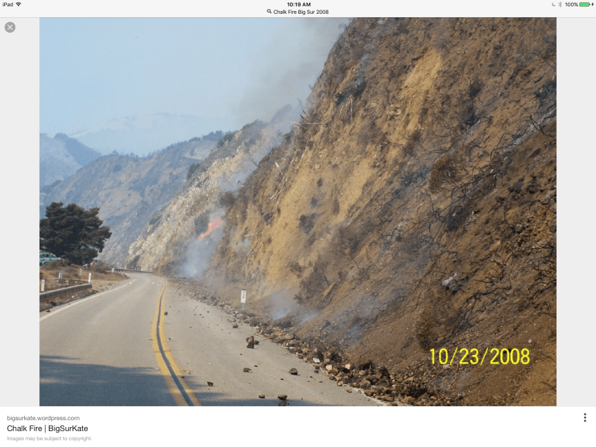
10:30 am – Since this fire first hit the national forest, the plan has been to hold it north of Nacimiento RD. Even today, on the situation report, that is the plan. In 2008, after the Basin Fire was finished, a new fire appeared on the South side of Nacimiento RD. In looking for info about that fire, I was referred back to my own blog … Hmmm…and was shown this photo:
9:00 am – Here is a slide show of some photos taken yesterday at Terrace Creek by Cordelia Cluett who lost the home she grew up in up Marble Peak in the 2008 Basin Fire. It provides a different perspective of the back burns yesterday. Thanks, Cordelia
From the Post Ranch looking East toward Ventana Inn of the back burn operation yesterday. Photo by Jeffrey Carmichael

7:00 am – Big Sur Valley is a bit on edge today, as communities usually are in front of a firing operation. The smoke is drifting down this direction more than it did yesterday, but still not as bad as it looked in town. Busy waiting for report ins from others, and checking on things, but hopefully, those in Big Sur Valley will start sharing their views, thoughts, and experiences after morning coffee. Until then, sent last night by Michael Minasian of Big Sur Center, taken at 5:50 pm at 27,000′

ee — re: your post of last night. I just called The Tickle Pink Inn here in Carmel Highlands. They have accommodations for tonight, but one King Bed room only. You might try them at 831.624.1244. Best of luck and Safe Journey!!!
[image: Inline image 1]
Just sent a Photo from West side of highway 1 looking to the East side of Highway 1
Kate here is a shot from Post Ranch on the West side of Highway 1 to a Firing Oop on the East side of Coast Ridge road 6pm Yesterday
Jeffrey, I just sent you an email explaining that WordPress does not provide for the posting of photos by readers, only by me, so email it to me, please.
may the day go well in this huge fight!
Sobranes fire phone folks just now (9am) have no info about where hwy 1 closures might be but think they may start at Palo Colorado again… I would expect that there would be firm info about where they intend to do back firing as that takes preparation but they’re sure holding their cards close to their chest about this. Makes planning kind of a challenge and I appreciate all the superb work they’re doing and understand there are a lot of unknowns. But surely they know where they’re planning to do burns?
While communications have generally been pretty good on this fire between all the moving parts and between them and the community, it is bound to break down somewhere along the line after over 3 weeks. It does make it hard to plan, however.
bigsurkate
Wonderful information gathering & distribution you’re doing. We ranchers south of you on the ridge top much prefer your very accurate & timely updates as opposed to those government services.
Please try to snuff that fire out … so we south of you don’t have to deal with it here in a couple of months or so. Keep up the good work, Kate!
J.
The plan is to stop it at Nacimiento, but if that fails, I’m sure they will want to use me as a fire break – have done it before… So no worries, I’ll stop it for ya, Jim
Huge amount of crews drove up in the last hour to restart the burn out on North Coast Ridge Rd, when conditions are right. Expect more smoke. This time it is a Sacramento strike team at our property. The Lassen strike team is following the burn operation south down the road. Across from us, to the east, the burn is still smoldering, has worked its way in the under story of the trees in the wilderness, every now and then we see a flare of a tree going up, but lots are still standing in the burn. Had a multitude of red fires out the window in the dark of the night, now it’s not so smoky. May all the conditions be favorable.
Sorry, to clarify, those red fires I wrote about were small logs in the burn, putting up light and color, but there wasn’t much wind, the smoke went straight up. So far so good.
Man, Kate, you really are full service, but you don’t deserve to have this hit your back door!
Hi Kate, If i remember correctly didn’t they stop the southern movement of the 2008 Basin fire somewhere around Dolan?
From Prince’s camp:
They have succeeded in the back burns at the dam yesterday, It was an amazing display of all crews working simultaneously. At sundown they suddenly stopped.this morning we see we have been saved! We are all grateful, stunned, and heartened as we hold our hearts in solidarity with our neighbors in Big Sur.
Wonderful news, Page…. Let’s hope it goes as well over here the next few days.
bigsurkate
I seem to remember something like that …. I’ll go see if I can find it on my blog…
bigsurkate
On July 5th, 2008, I wrote this about the Basin Fire: According to a member of the BSVFB, the Dolan Ridge Line is holding really well. Lines are being expanded at the Rodeo Flats, and both BSVFB and the USFS IC seem to be confident that this line wil hold. While some reports are putting the southern closure at Limekiln, all recent reports are putting it back at Lucia Lodge, including the Mandatory Closure memo by the Sheriff. If the chp closure is still down at Limekiln, which I have not seen, I am not aware of why it has not been moved.
bigsurkate
Hopefully they can use the same Dozer lines and hold it there.
More images from Soberanes Fire burn-off operation.
http://scophoto.blogspot.com/
Really something, what powerful stuff these photographs, your report. What an experience for us all, can’t wait til it ends, thank you, Kate…you are astounding.
The opening paragraph in Scott Moffat’s linked page mentions “Kucher Trail.” Where is that located?
Prayers for all of you. I’m glad to see the note from Soaring – she is a neighbor to my family-in-law, and we have been watching the fire’s onward march. I have clear memories of some of the striking stories she shared with us of her experiences watching fire up on the ridge in years past.
Never mind my above question — I figured it out based on maps. I’ve hiked past it but never knew it had a name.
Wow! Great maps, Thank you John Chestnut!
We are planning to go to Esalen on Sunday and are wondering how safe it is. They are still open and apparently safe for now but wondering if the fire could reach there in the next week. I can’t figure out from the maps where Esalen is in relationship to the fire.
They are anticipating doing a back burn all the way past Esalen to Big Creek, where they hope to turn the fire inland. However, as with all things having to do with fire, it is dependent on weather and winds, either of which could cause the fire to become erratic and unpredictable. Hotter and driee weather over the weekend is predicted, so there is no way of knowing what can or will happen in the next week.
I’m so sorry you all are dealing with this heartbreak. I live in Santa Clarita so am no stranger to wildfire.
I’m looking for opinions regarding reservations for my honeymoon at Ripplewood Resort 8/22-8/26. Im thinking even if the threat is over in that area by then, roads still need to be clear for clean up? I know you cant look into your crystal ball…..but do you think we should be working on plan B?
Mario, the mailman, mentioned needing to get to Deetjen’s by 4:30 in case they closed the road. I was speaking with him @ PV School @ 3ish. My thought was the closure would be starting at there @ Deetjens. That squelched my plans to go to the fundraiser @ the Golden State Theatre, bummer. It’s now 5:30 and I haven’t heard of the road closure, but they said they only had to give an hour’s notice. Yesterday’s town trip to Monterey was a total disconnect from the fury of the fire on the backside of the mtns. Just some spillage creeping down Mt Manuel at a snail’s pace. But it was clear sailing going north and south on the way back, so nice for a change.
Hi Ripple, it’s so hard to figure out what to do about travel plans, isn’t it! For some perspective, the fire has come as far down the coast as Pfeiffer Big Sur park, which is 11 miles north of Esalen. In 21 days, the fire has come about twice that distance down the coast. There’s likely to be closures of Hwy 1 during the time you are scheduled to be there, which will affect your plans if you are coming/going to/from the north. The biggest concern will likely be air quality. Whichever way the wind blows has bad air and the wind changes direction often. I know that there are still people making their pre-planned trips to locations in the fire area. If you do go, you’ll need to be careful to keep out of the way of fire workers and be ready to evacuate at a moment’s notice if things get worse.
Hi Gen. I’ve been watching things closely to see what I should do about my travel plans in the area the week after yours, so I have some perspective on your question. Ripplewood is right in the thick of the current fire mess on the southwest perimeter. The next 2-4 days are critical for that area. If the battle is successful, then 10 days from now when your trip is scheduled, everything could be contained and trying to get back to normal. I know the businesses are encouraging people to still come if/when things are safe. If you have the stomach to wait longer to see what happens, you might still be able to make it. If you do come, you might have to work with closing of Highway 1 as the fire makes its way further south. If you’d rather know now where you’ll be staying for your honeymoon, your best bet is to make other plans… and visit Big Sur when it’s not on fire! Good luck in making your decision and congrats!
Hi Ripple,
A family member was at Esalen 7/30-8/7. She said some people were effected by the smoke during that time. Her workshop was moved inside. She only felt it was bad for two days. Of course, this was several almost a week ago, and the fire and backburn is much closer to Esalen now. Consider your health, esp if you have heart or lung issues. I believe Esalen will give full credit or refund. Best of luck.
Opps. Delete “several.”
in 2008 the dozer lines and firebreaks were installed at Dolan creek ( miserable place for them, should not be used again ) because the fire had gotten ahead of firefighters on the Coast Ridge Road and was in the coastal canyons. ‘plan’ this time is that fire will not be ‘allowed’ to burn on that side of the coastal range. I’m on that side and in one of those canyons so boy howdy I sure hope all goes according to plan !
how is the coast ridge backburn going? Any news?
Those of you from out of town – Monterey County is currently under a state of emergency – not a good time to visit. I say this with love as I want your visit here to be one in which you can enjoy everything this amazing place has to offer + right now is just not the time.
The Soberanes Fire has an estimated containment date of August 31 so maybe you could plan to visit the central coast areas like Morro Bay or further south like Santa Barbara + head north later after things have settled down here. xx
Sweet dreams Big Sur. Stay safe. There are people around the world who think you and the people who live among your tall trees are amazing.
Thank you, CoCoLu
I’m wondering for those who are scheduled to come to our area and wouldn’t mind staying further away, Santa Cruz County, while popular, may have something? The Visitors Council of Santa Cruz County MAY be open on Saturday limited hours and could help or maybe they have an online reservation system or recommendation system, AAA too? Watsonville has the Comfort Inn on Airport Blvd. which a friend stayed at and liked. It’s around 1.5 hours away from Big Sur, certain parts of Santa Cruz County up to two hours away. Salinas has had some moderate air quality from the news but aside from one day, Santa Cruz County has not though we have smelled the smoke and it’s been socked in with fog/smoke like any other area. Or maybe a larger area such as Morgan Hill/Gilroy which is off Highway 101, and other areas of Silcon Valley. I’ve heard a lot about Trivago to book hotels online, don’t know anything else.
Craig underwood arsonist of 3 wildfires in Los padres national Forest.
Craig underwood look him up under arsonist
Craig Underwood’s arsons occurred in 2004. All three totaled only 800 acres. He lived in Greenfield near Arroyo Seco and started all his fires near there.