

8/15/16 –
5:00 pm – 50 acre spot fire on West Side of Lake
7 am – 4300 acres and 10% containment. Here is John Chesnut’s MODIS map of the Chimney Fire:

8/14/16 –
5:45 pm by Bill Mortiz

Today around 3 pm from Cambria by Joan Schlicher. Rocky Butte is on the right. Looks like a nuclear explosion.

3:25 – right now, photo by Michael Handy:

3:00 pm – SLO County Offices of Emergency Services says the fire has quickly exploded and those in the Tri-County and Cal Shasta area are to evacuate immediately. Those who can not get out of the area are to go to water’s edge where the SLO County Sheriff’s will be launching boats for evacuations.
10:30 am –
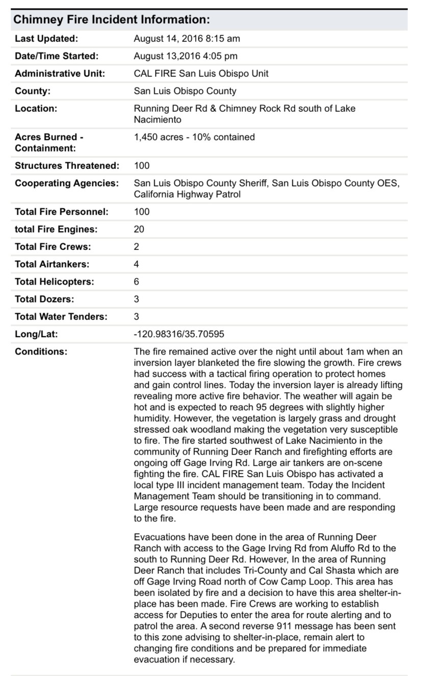
8:00 am – acreage updated to 1450 acres, 10% containment.
6:30 am – Chimney Fire is now 1000 acres and 10% contained. Here is the most recent MODIS from John Chesnut:

***********************************************************************
9:pm – latest update is 850 acres, back burns initiated and going well, VLAT photo by Rick Modlin:

Here’s an aerial:

5:10 pm – AA says multiple spots up to a mile ahead of the main fire are starting to take off, fire now 350 + acres, now 450 acres. BTW, it is 107 by the Paso Airport, so it will be about the same here.
5:00 pm – As if my life wasn’t busy enough – this is a lot of fun … A fire just broke out ESE of me on the West side of Lake Naciemento. It is 100-200 acres and moving fast. It is on Chimney Rock RD. Near Running Deer Ranch, which is being evacuated. 5 tankers assigned at this point. This could get interesting – one to the north west of me and one to the south east. Hmmm…Here is what it looks like.

That looks all too familiar. I hope they can stop this one early!
Oh, Kate😞
Who is AA?
AA is Air Attack…that is the one in charge of directing the tankers and keeping an eye on things.,
I’m taking tonight off and visiting my friend in los Osos tonight, I get to Paso Robles and see the header from this fire. I look up and there’s a small Cal fire plane flying over me ready to hit it. They have six planes in route right now and one VLAT. seems like this damn fire is following me.
If this thing takes off, it’ll will be serviced out of Greenfield crews.
In 15 minutes my team is already mobilized to get additional breakfast down if needed tomorrow morning and hydration. We will be ready if Crews increase.
This is another bad area of thick brush and bad access with lots of homes through out.
Kate…how far from you is this Chimney fire?
It on the other side of the Santa Lucias so still quite a ways. I can see Lake San Antonio from here, but not Lake Nacimiento, which is just south of LSA
bigsurkate
While the Cal Fire Paso Robles Air Base is near, a lot of their planes aren’t.
One would think (hope!) that with the Soberanes Fire in “their backyard” that they would prepare/protect their property. Don’t think there can be a bigger HINT!
Paso’ S tankers haven’t been flying the Soberanes, at least today. They sent 7 from Paso already.
bigsurkate
I wonder how this fire started? Human? If so, I hope they catch ’em and put his feet to the fire, literally…
So…you’re not seeing the smoke from the Chimney Fire, Kate?
Not even speculating yet, it’s only been an hour and a half. Trying to get the resources needed to protect lives.
bigsurkate
Oh, no, I’m seeing a lot of smoke from the Chimney.
bigsurkate
Kate–So very sorry to hear this news of the new fire and increased danger for you and all concerned. Your blog has been a priceless source of information, for although now in Louisiana, my roots and friends are in Monterey-Carmel-Big Sur. This news also falls close to home, and I can’t thank you enough for getting the word out. My aunt and uncle live near Nacimiento and our family cabin at the lake is accessed through Running Deer. I pray the new Chimney Fire and the Soberanes Fire will not overtake more residences, business or individuals. Bless you and thank you. If I hear anything from family in the area, will let you know.
Running Deer and Chiomney Rock are under evacuation orders. Haven’t been able to get thru the fire to notify some residents, but don’t know which ones. I’d be concerned about your aunt and uncle.
From Twitter: SLO County OES Verified account @slocountyoes 43 minutes ago #ChimneyFire: Shelter location PENDING OPENING: Flamson Middle School at 24th St & Spring St in Paso Robles. Red Cross staff on the way.
Thanks Kate–haven’t been able to reach my aunt and uncle yet, so checking in with my cousins now.
Kate–thanks for all your help yesterday and this morning. I’m sure things are going to be busy for you and others there today. Keeping all in my thoughts.
In case it’s of any help to others, the word from my relatives re: Chimney Fire – They received the reverse 911 call yesterday, since the family cabin was in the evacuation area (near Soda Rd., off of Gage Irving Rd., which forks from Running Deer). They were at Heritage Ranch (home) when they got the call and in touch by phone with others who have homes/cabins in the burn area. Folks were evacuating by boat (my aunt and cousin went in that way yesterday), since Gage Irving Rd. is the road out, and the fire was burning strongly there. My cousin (with Santa Barbara fire) is keeping them informed, and my aunt said the helicopters had just flown over Heritage Ranch.
My friends in Oak Shores say it just jumped the lake and they are evacuating.
Jumped the lake? How?
I’m not quite sure. It is what she posted on FB as they finally evacuated their house. Reading the reports, I’m wondering if they were not just seeing the flames come roaring over the ridges as it turned north. They’re at the southern edge of Oak Shores but offline now so I am unable to confirm any of it.
Kate. Thank you for everything you do on here. This community is blessed to have such a resource.
Those last few pictures you posted on this fire gave me the willies. Vertical development like that is extremely dangerous, it can result in a fire storm with little warning. My recommendation to anyone reading this who is or knows anyone in that evacuation area is to get out quickly and leave this one to the professionals.
I feel I should clarify my last post a little to avoid crying wolf. I’m sure it is highly unlikely to nearly impossible that anything as severe as an actual firestorm will occur from this. Seeing that sort of behavior just reminds me of how unpredictable these things can be and makes me jittery.
JA, I just read one definition of a firestorm: https://en.wikipedia.org/wiki/Firestorm
Wikipedia
A firestorm is a conflagration which attains such intensity that it creates and sustains its own wind system. It is most commonly a natural phenomenon, created during some of the largest bushfires and wildfires.
A fireman on this Soberness Fire said that the tools they use to predict fire behavior are off the scale! They are seeing behavior they have not seen before.