

Noon: Here is the progression map from the inception until this morning’s mapping:

and for you purists, here is the link:Progressive Map link to PDG
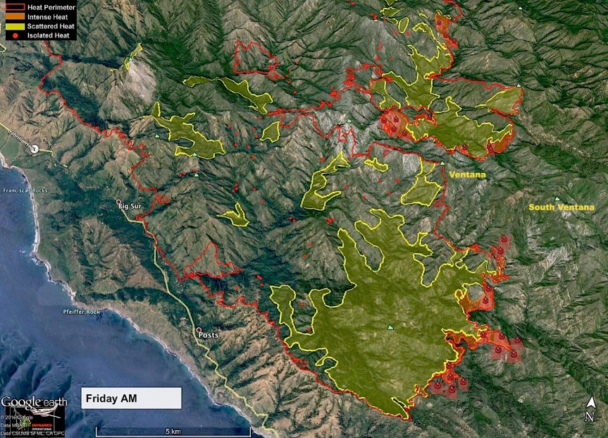
John Chesnut maps:

7:45 am – Just in this report from Joelene who attended last night’s meeting at Cachagua Store:
“Howdy the briefing last evening was very informative. Many concerned residents from Tassajara showed up. The USFS is going to take over this fire Friday, but Cal Fire is here to stay as long as this fire is active. Operations will work on the bounds of fire lines. Strike teams are at structures in Miller Canyon and Pine Valley. Please know that while the USFS has a different approach or tactics, Cal Fire is here to stay and protect us. In order for them to help us we must help them. If you feel lack of communication is occurring, contact 8312040446. Or e mail soberanesfire2016@gmail.com if still no return response, keep trying. As their priority is lives first, structures are close behind. They work closer to the current fire breaks and as the fire moves closer, the crews move outward to structures and properties. Those who have yellow paper that says undefendable, please contact a Cal Fire official and ask them to reassess the place, especially if you have done more clearing work. They are not abandoning anyone. They need to be able to protect what is accessible. They need to be able to enter your property AND turn around, especially up Tassajara. Right now warning evacuation remains, and roads are open. You can come and go, with vigilance that this is apt to change suddenly. With all due respect, Cal Fire is working with the sheriff department on communications for a window advance notice of twelve hours of a hard or soft closure, IF back firing operations make the decision to back fire Henningson Ridge. It may not have to be done. With the good old fog walking in, the fire has been low and slow burning, making it easier for fire crews and personnel’s to work it…. Much to our long standing patience….. Cal Fire and all the fire technicians appreciate your patience and support. As much as you do, they want this fire to be beaten as soon as possible and it will come to pass. Just a bit longer. Please continue your wonderful support and patience.”
6:30 am – This is becoming surreal … Day 36. Five weeks, down – now starting the 6th week of monitoring this fire. Lots of fog on the coast, pretty thick, this am, with the smoke sitting on top of that. AND, it is amazingly cool, almost cold. At least I can see Cone Peak, this am.
First up – the IR Topo map and link:


And here are the fire behavior and weather predictions. These come from much larger reports, so they are screen shots, and there are no direct links to these pages.


Local weather experts alerted us for a wind direction change & to expect more smoke in CV & Monterey- sigh.
Smoke to north of fire means that winds are pushing fire back on itself; a good thing for those of us still in the path of the fire!
Nice to read Joeleen’s account of the meeting. Very informative. The fire did get and is getting help from the persistent benign weather pattern.
Thank you Joeleen for your excellent report on meeting in Cachagua. Just one question I would still like answered. Where are the 410 houses continually mentioned on cal fire report. Kate’s house in Big Sur? My house off Tassajara? Yours? I’m in France but I will try and call the numbers you gave us to get the answer but if anyone knows please let us know.
Sorry I failed to mention wanting to know the whereabouts of the 410 homes specifically in harm’s way or threatened by fire.
I very much doubt my house is included in that, but I suspect the houses in Miller Canyon, Tassajara, on Coast RD. From 1.5 miles in until Marble Peak are, as well as Jack English’s Cabin (even though it is protected with wrap, it is still vulnerable.) I would look at where the evac warnings and/or orders are for a better understanding of which ones are under threat.
bigsurkate
Big Sur Kate- Soberanes Fire: Communications inquiry/shortwave radio hobbyists:
Do you have any streaming live channel links for emergency county services, Cal Fire Operations Control with fire (aviation & foot ) crew channels or Apps where observers can listen & follow? ( I should have asked someone a long time ago).
Thank you, in advance..
Broadcastify usually carries many of them.
bigsurkate
Yet again, Kate, thanks for all your coverage! Down here in Cambria, Cal Fire has posted a large bulletin board with continual maps and updates. Talking to them there, outside the Chamber of Commerce, the one fellow said he’d just met you (can’t recall his name) and was so impressed with your knowledge and dedication to keeping all abreast. I believe you gave him a map of historical fires in the area from years past. Said he came from the Sobranes a week ago and is now on the Chimney Rock….SO THANK YOU ONCE AGAIN and blessings to all xoxoxo
I know which one he was, but can’t remember his name, either. They were supposed to send me the photo they took of me with him, but the USFS gal who took it forgot.
PS, Nice to hear from you, Lady Tie Di.
bigsurkate