

5 pm – here is a photo of the firing operation behind Anderson Peak by Cordelia Cluett:

Great photo, Cordelia. Thank you for sending it.
Noon – from a resident of Partington Ridge: “I spoke with one of the firefighters this morning and they are headed back to Partington today because they are going to try and back fire a small area behind Partington that didn’t burn before…”
10:30 am – still having trouble uploading maps, but did at least get the link for South Ops up, and finally showing enough of the south that I am in there. Here is the daily report:
The fire is still 2 1/2 miles south and west of Tassajara. Fire retardant is being used from the air to help manage the fire. Smoke plumes are visible from Tassajara, but the air quality in the Valley is good.
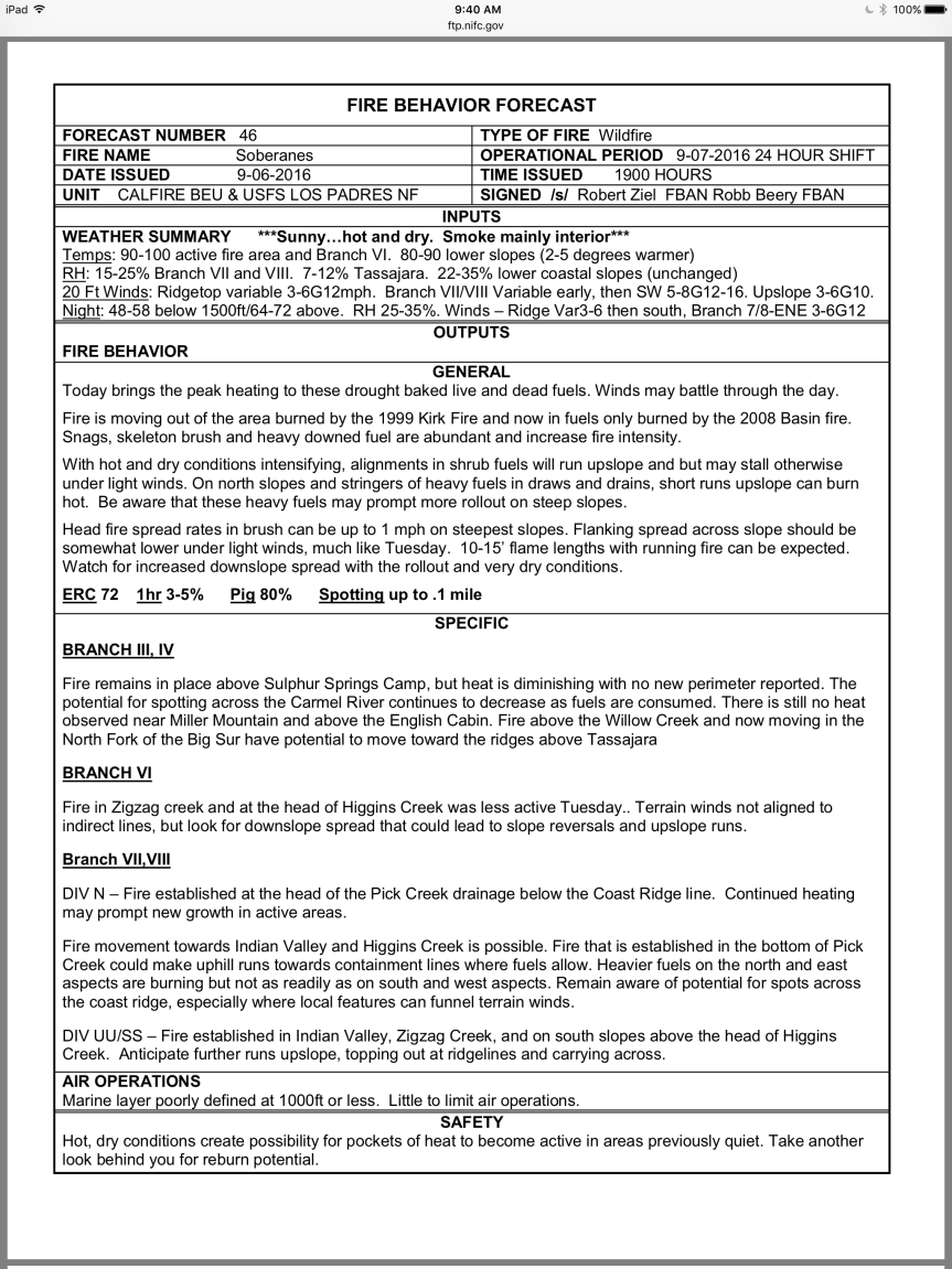
Total acres: 101,490
Acreage increase: 511
Containment: 60%
Total Personnel: 1,196
Temperatures are expected to be hotter today, with highs in the Interior of the fire expected in the 100-degree range. High pressure is moving inland, bringing moderated southwest winds over the fire area. The southerly winds could produce visible smokes for residents on the north end of the fire.
Fire is burning actively to the east along Zigzag Creek (picture below) and above the Willow Creek drainage. Fire is mainly moving through the heavier brush and dead fuels from the Basin Fire of 2008. Easterly fire growth on the ridge between Zigzag and Willow creeks is expected. This is creating short-lived columns of smoke visible from Tassajara and Highway 1.
There is some fire activity around Black Cone Mountain and the Willow Creek headwaters. Some fire activity south of the North Fork of the Big Sur River continues to spread as slope and fuels line up. Managers continue to monitor fire spread, hold and improve control lines and assess proximity and thread to indirect control lines.
6:30 am – this morning’s maps are being difficult and do not want to upload. Will be uploaded when cooperation is achieved.

If possible, I will load the weather and fire behavior discussions from the IAP:

Hello Kate,
CVV air quality is poor at best and humidity is low for sure, temps higher than normal for so early in the day. There has been 1 helicopter pass by overhead moving from Toro to the Tassajara area in the past 15 minutes.
thanks for the report, Andrew.
bigsurkate
Excellent updates. Thank you. I have eyes on the Partington Ridge plume of smoke right now. You are right. The big column of smoke is actively rising behind the ridge. the time now is 12:20 pm.
“Firezat Wrap Protects Structures from Wildfires”
I’m curious if any residents are familiar with this protection product. I came upon this feature via social media, I have no connections to it, but, someone must have some similar findings or experiences/ reviews to report;
appreciate your input.
http://www.nbcrightnow.com/story/29879974/firezat-wrap-protects-structures-from-wildfires?utm_source=dlvr.it&utm_medium=twitter
Andrew, I have a neighbor who has invested in this. The only drawback, as far as I know, is that of securing it, because, as we all know, wildfires create their own winds, and winds can whip this off if it is not secured properly. It comes with the proper securing devices or mechanisms, but don’t know how easy or difficult they are. The really good things about them are they can be put on much earlier than foam, and they are easy to take down and put away for another time, thus reusable.
bigsurkate
Yup, see the plume from down here. Was glad to get a heads up so we know what is going on.
bigsurkate