

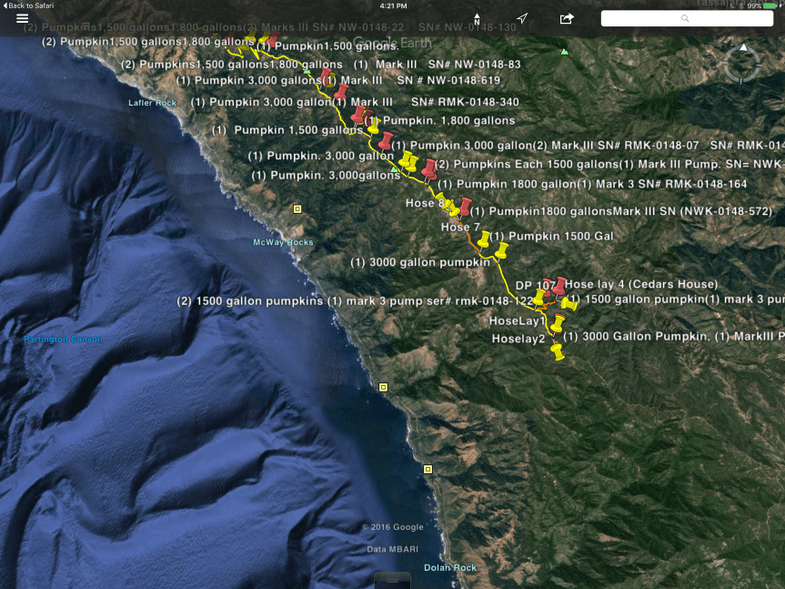
4:30 pm – look at the fascinating map of all the water sources along the western containment line I found on Google Earth. I remember these “pumpkins” from prior fires being called “bladders.” I like pumpkins better.
2:30 pm – From today’s firing operation around noon between Anderson Peak and Marble Peak, Photos by Cordelia Cluett:
2:30 pm – John Chesnut sent this to me this am, but life happened, and I am just now getting around to posting it.

6 am – We lost another 605 acres of forest for a total of 103,847. Here are today’s maps:


And here are the fire prediction and weather forecast discussions:


lots of fresh smoke plume driving over Jamesburg. Anyone know where it comes from?
Called info, it is firing ops at Anderson, Big Sur.
Thanks for the info, Regine. I can see lots of smoke right now, but no normal plume. This one lays down going toward the west, and then at the upper levels (presumably due to unstable air) literally hooks around and heads back east. Very interesting.
bigsurkate
A 20 percent chance of showers and thunderstorms… I am going to read this as 80% chance there won’t be thunderstorms.
How is Pacific Grove and Carmel Valley looking nowadays with the smoke, fire smell and all? (mid county and down to Crossroads)?
It’s been less than it was, I understand, but the winds are coming back tomorrow, so may blow the smoke north, I can’t remember which direction they are pre
bigsurkate
“SOBERANES FIRE: EVACUATION WARNING EXPANDED
An evacuation WARNING along the east side of the Soberanes Fire has been expanded to include an area along Arroyo Seco effective 6 p.m. on Saturday, September 10, 2016.”
http://inciweb.nwcg.gov/incident/article/4888/33628/
Thanks, Denise, I got the evac warning up as its own, new post. Thanks for the heads up. I didn’t get the notice, but had to go to inciweb to get it.
bigsurkate
From Inciweb: “Continued holding actions south of Los Padres Reservoir and point protection of values at risk within the indirect line and preparation for structure defense ahead of the main fire. Worked to ensure adequate staffing to conduct firing operations along indirect control line in the event fire gets established east of the Carmel River.”
Someone, since this is getting back in my territory … what does “point protection of values” mean?
My pleasure Kate. Dealt with comm. cycles and computers – sometimes we just blamed aliens. :::)
Pumpkins – I agree – better. Damn. Another thing to go learn about. lol
Kate…is there a way to see the water sources map in a larger size? Hard to read so small. May be my aged eyes….?? 😉
Tzila, not sure I can find it again, and even if I could make it larger, then it wouldn’t cover the entire line of pumpkins.
bigsurkate
Tzila “Z” Duezel
In case Kate can’t find source and/or PDF file.
Ctrl+ (control plus) will enlarge map and it stays better clear. This enlarges entire page, not just map.
Ctrl- (control minus) or “reset” in menu bar will return page to normal size
very handy…
Regine, oddly enough, I just had a guy named Mark who is one of the fly-over guys on the Soberanes fire stop in the Lucia store and he told me “Values” are the houses and businesses that they are protecting. Then I got on here to catch up with yesterdays writings before reading today’s, and there was your question. I love the way the UNIverse works; especially in Big Sur 🙂
Thanks Denise…
Thanks, Kate about the PG and environs update AND for everything you do, one day we won’t be talking about this fire but I know how exhausting all of this is for all of you. It was a bit windy over in Hollister today but got very cold toward the end of the day, ditto for the Capitola area.