

3:00 pm – Rana Creek Staging Area this am by Howard Jones

11:30 am – I’ve never paid quite such close attention to the winds forecasts as I have been the last two months. Here is John Lindsey of SLOs predictions: “Moderate to fresh (13 to 24 mph) northwesterly winds will develop along the coastline this afternoon, decreasing tonight. Gentle to moderate (8 to 18 mph) west to southwesterly winds are forecast on Monday into Tuesday. Fresh to strong (19 to 31 mph) northwesterly winds are forecast on Wednesday, increasing to strong to gale-force (25 to 38 mph) levels Thursday into Friday, decreasing over the weekend.”
So, for me, that explains the extensive back burn while winds were favorable, because very soon, they could have really threatened Cachagua, Jamesburg, and Carmel Valley.
10:05 am – from the USFS:
**Update Soberanes Fire**
Current Size: 113,259
Containment: 61%
Personnel: 1,921
Burn out operations were successful on Saturday on the eastern edge of the Soberanes Fire. Burning occurred in the area of Chews Ridge north towards Los Padres Dam. They strategically put fire on the indirect line to prepare the area for any future fire activity. Smoke will be heavy in all areas near Carmel Valley, because of the wind directions.
Evacuation orders have been lifted for Coast Ridge Road from 1.5 miles to the Ventana Inn to the end of Coast Ridge Road at Marble Park, and roads that leave from Coast Ridge Road. Also for Big Sur South Coast Center area and Big Sur Partington Ridge area. All other evacuations orders and warnings remain in effect.
As the fire continues, operations names the number one priority as the safety of our firefighters and public.
Photos are from yesterday taken by, Hugo Patino – Public Information Officer


10:00 am – from John Chesnut: “The Sunday AM (3:50 AM) VIIRS overflight has been posted. Shows some further expansion west and south.
The fire front along the burnout is 12 miles long. Will be interesting to watch how quickly it climbs the shaded north slopes in Miller Canyon.”

8:00 am – here is John Chesnut’s google map of the burn out area:

6:45 am – Here is today’s IR flight map. It was taken at 8 pm last night, and shows an increase of almost 5,000 … Most, if not all, of it on the east side from the ambitious burnout operation undertaken this week. I will add the rest of the maps after I’ve taken care of the doggies.

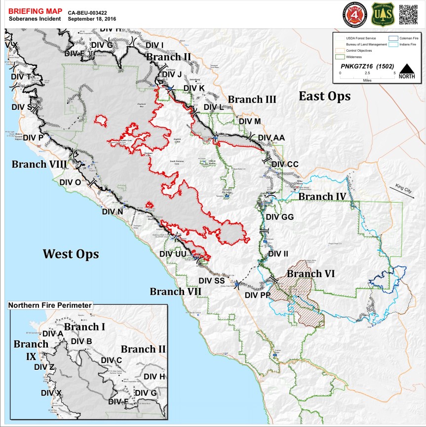
Briefing Map in PDF
Now, I’d like to zoom in on Div SS, as a new “fire line” has been drawn between Rodeo Flats and DP-110. What does a “fire line” mean? Take a look at the topography. I might be missing something, but there doesn’t appear to be any dozer line or hand line, or any way of putting in either one. How can one stop or start a fire line here? I think I will be making a phone call later this am to see if I can get an explanation.

Here are today’s fire behavior and weather prediction discussions for both sides of the fire:


Jason, great to hear you have your humble abode in the wilderness. And tiny on top of it. I like that. Lived in just about 200 sq feet for 3 years myself and loved it. The 1.5 mile hike is another story. If this is your full time home you will remain in shape.
And yes, it is your choice, and a reasonable one, to paint in order to preserve your building efforts. Also, I believe it is law, even for tenants, to maintain defensible space around their dwelling.
As to the idiotic tourists? I do not agree with “The more they see, the more they will want to preserve it.”
5000 acres gone up in smoke, a layer in CV about 3500 ft deep with another significant layer over it at about 5000 ft. To much smoke at once. This whole backfire is now going its engorging way to meet the the West.
On Sartopo.com, it looks like this backfire may already be east of the Carmel River, where the fire had given up. Is this going to start burning again what is left in there to burn?
Will go check and feed my goat girls now and see how they fared without my air purifiers, which I got for this Sobering occasion.
Pics of your doggies next? They are the best! Well, along with all the other furry ones of course.
thank you for all you do!
Thanks for planning to making that SS section phone call. Also, it was stated somewhere yesterday that the fire crews are moving to near Hunter Liggett, saying it is closer for the crews than Toro Park. Closer to what? Certainly not Chews Ridge.
Rodeo Flats to DP 110, next burn ops line?
What a mess, all I discussed yesterday has come true- visibility is broken throughout the valley- trouble breathing too. Ugly Sunday conditions. If this continues tomorrow I’m sure local schools will close.
So sorry to hear this. I can see why from here. I have decreased visibility, but nothing like you have.
bigsurkate
This probably deserves it’s own blog- but in response to yesterday’s discussion on how aggressive to be. In other parts of the country the USFS- Colorado a few years back comes to mind- wanted to do a series of controlled burns to eliminate dead brush in areas that hadn’t burned in 50+ years. Those plans were stopped by lawsuits and while the issue was in litigation a real fire broke out and utterly devastated the areas under litigation. One factor in fires to bear in mind. When you have 50+ years of accumulation fires burn much hotter and literally bake and sterilize the ground. These areas have to be re-seeded and start from scratch. While I am concentrating on the plant growth- but they are the base of the food chin and this new growth provides the fodder for the critters. With fires like this one the USFS will almost certainly keep access to the burned areas restricted for the next year or so. Certainly through the rainy season as they will try to re-seed and get at least some ground cover started to limit soil erosion. Some places will heal faster than others of course. The role of fire in the Chaparral Community is pretty well understood . For those of you who haven’t done so- please check out Kate’s archives here. It shows a lot of the process that took place after the Kirk fire.
Kate:
Re the planned wireline form DP-110 to Rodeo Flats.
Looks like DP-110 is Escondido Campground.
Overall it looks to me that the line follows the divide separating the Arroyo Seco drainage from the headwaters of Lost Valley Creek.
David, you are so right, and this is a perfect thing for us to be talking about fire ecology and all that it entails. It was in 1910 after “The Big Burn” or the Big Blow up in Northern Idaho, that fire tactics changed. That fire killed 78 firefighters. August 20, 1910 was the “day the mountains roared.” This was the first great firefight by the US Forest Service. “The idea of fire protection on public lands meant firefighting was, in 1910, a novelty.” (Stephen Pyne, The Big Blow Up.)
bigsurkate
Rodeo flat trail has been bulldozed several times before. I believe that ‘Planned fireline’ would be a new disturbance to the wilderness.
Heavily filtered sunshine & particulates, peachy colored smokey skies, airfield is slowly coming into view, breezes almost non existent earlier are barely making a dent with the surrounding trees. Weather team nailed it today.
Only planes I do hear flying about must be the one’s that create those IR surveillance high flight elevations pathways data gathering missions.
Dave, it doesn’t indicate it is to be a dozer line, and in fact, I don’t see how it could be, given the terrain. After emails from Steve Harper and others, I don’t think this will come to pass.
Kate:
I had wondered that myself. This area is quite rugged- typical Coastal Range topography. Just in general – fires tend to have relatively easy uphill runs but depending on winds stall at ridge lines. A divide is the natural place to put a line but in this case it would have to be a hand line and traverse some low spots. I noticed that the resources allocated for this fire have increased by several hundred personnel and is closer to what they had before the Chimney Fire sucked up resources. This certainly provides some additional scope for the ICS Planning section that the Alaska IMT didn’t have.
jfwiw-For people wondering about the northern blackburn- the maps show you the strategy that is being applied for the moment as winds are favorable. This creates another indirect fireline to further the goal of keeping the fire within the confines of the wilderness areas. It looks to me that once this line is secure the resources can be reduced along through here and allocated elsewhere to speed up containment.
David, Looking forward to your comment becoming reality!
I pray for favorable winds and early rains…. sorry that “favorable” winds are not universal in our little world. Sooooo tired of thick smoke…thick throat, thick air…