

11 pm – in the last hour I received two reports from Chew’s Ridge, Jessie wrote me re lots going on out there, After that, Tom Little Bear Nason posted this to his FB page: “The Fire jumped the Dozer lines over at Cahoon Ranch and is headed up Anastasia Canyon right up towards Tassajara RD and our Ranch and its raging out of control right now🔥⚠️🔥
It’s Burning fast and hit with winds up 40 mph!!!” Prayers for all.
From a comment on my FB page: “I just called the Cal fire hotline/ and they said “it did jump tassajara in one place up there and there’s a “small” (?) spotfire that they are monitoring -and sending in more resources. they ARE going to do a mandatory EVAC- but it will be up the road farther. chews Ridge to Bruce ranch-and a couple other ranches that I am not familiar with-(tosh ranch?) he didn’t seem to think that lion Springs would be evacuated and certainly not down at Jamesburg or me… at least not tonight anyway. 😁
and- that they will be doing a reverse 911 for the affected areas within the hour.”
Here are three maps Luke did up for me when I sent out a desperate cry for help (I used to be able to do these, a few fires ago, but lost that knowledge somewhere) which he most promptly offered. We don’t have the landmarks on it due to lack of time, but those in the area will recognize anything of concern to them.


7:30 pm – just spoke to a PIO at operations about some concerns I have. Strike Team from Santa Cruz and Santa Clara was toned out around 5:30 pm and there are some MODIS spots outside containment lines – but remember, MODIS is notorious for picking up heat in the columns, so we will have to wait on this for confirmation. He had not heard from operations, so was unaware of any problems out in the field. Seems communication with their own PIOs cannot be updated on conditions as fast as we would like. He will be recommending another community meeting for the Cachagua/Carmel Valley folks, but in the mean time, he encourages all of you to call the information line anytime with any concerns you have.
12:45 pm – Huge plume visible from the Eastern side of the fire. Must be more firing off operations.
Here is the VETS IR flight from this morning: (BTW, VETS is an acronym for a private company that does day-time Helicopter IR flights – usually two a day.)

From John Chesnut:

10:30 am – from the USFS:
Incident: The Soberanes Fire is burning in the Los Padres National Forest, Ventana Wilderness, in Monterey County, CA. The fire was started by an illegal campfire on July 22, 2016, in Garrapata State Park.
Agency Jurisdiction: CAL FIRE San Benito-Monterey Unit/Los Padres National Forest.
Incident Command: California Incident Management Team 4, Rocky Opliger, Incident Commander.
Current Size: 117,656 acres (80,462 acres CA-LPF; 37,194 acres CAL FIRE)
Containment: 67% Personnel: 2,021 Cause: Illegal campfire Injuries: 1 fatality, 7 injuries
Structures Destroyed:
57 homes, 11 outbuildings
Structures Threatened: 410
Crews: 45
Engines: 116
Helicopters: 7
Dozers: 12
Masticators: 2
Water Tenders: 11
Current Situation:
Firefighters have made strong progress on the Soberanes Fire, as evidenced by the increase in the containment level to 67%. That is an increase of 15 percent since September 13. The increase is largely due to weather conditions that contributed to favorable burnout* operations. Activity is predominantly in the south-southeast areas of the Soberanes Fire. The burnouts are key to the firefighters’ success over the past days in widening and strengthening the indirect* containment line.
The fire continues to burn in remote, rugged terrain, including in the Ventana Wilderness. Firefighter and public safety remain the priority in every situation.
Heavy smoke in the area on Sunday was the result of an atmospheric inversion that held smoke from the burnouts in the valleys. Area residents will continue to see smoke columns and atmospheric smoke today.
Winds in the region changed today, with flows now from the south and southwest. The change may mean more erratic winds affecting the fire and pushing smoke toward the east side of the fire. Continual monitoring of weather and evaluation of forecasts will be used to determine when conditions allow for burnouts.
All evacuation orders and warnings remain in effect on the southeastern side of the fire.
For more information, visit: http://inciweb.nwcg.gov/incident/4888/ or follow us on social media at http://www.facebook.com/LosPadresNationalForest or http://www.twitter.com/LosPadresNF.
*Burnout is intentionally burning vegetation from the indirect fire line.
**Indirect line: a fire line constructed away from the hot edge of the fire.
###
Forest Service Shield
Jennifer Gray
Visitor Information Assistant
Forest Service
Los Padres National Forest
p: 805-961-5795
f: 805-961-5729
jsgray@fs.fed.us
6750 Navigator Way, Ste 150
Goleta, CA 93117
http://www.fs.usda.gov/lpnf
Twitterhttp://wwwstatic.fs.usda.gov/images/facebook.png
Caring for the land and serving people
Here is John Chesnut’s map:

4:30 am – Day 60. *Sigh* Today we tied the previous record for the longest running fire in the Los Padres National Forest held by the 2007 Zaca Fire in Santa Barbara County…a dubious distinction, at best. Almost 4,400 additional acres were scorched yesterday, bringing the total to 117,656. Here are the maps:


Here is the Branch III map that covers the Chew’s Ridge burning operation:

Chew’s Ridge Operations Map in PDF
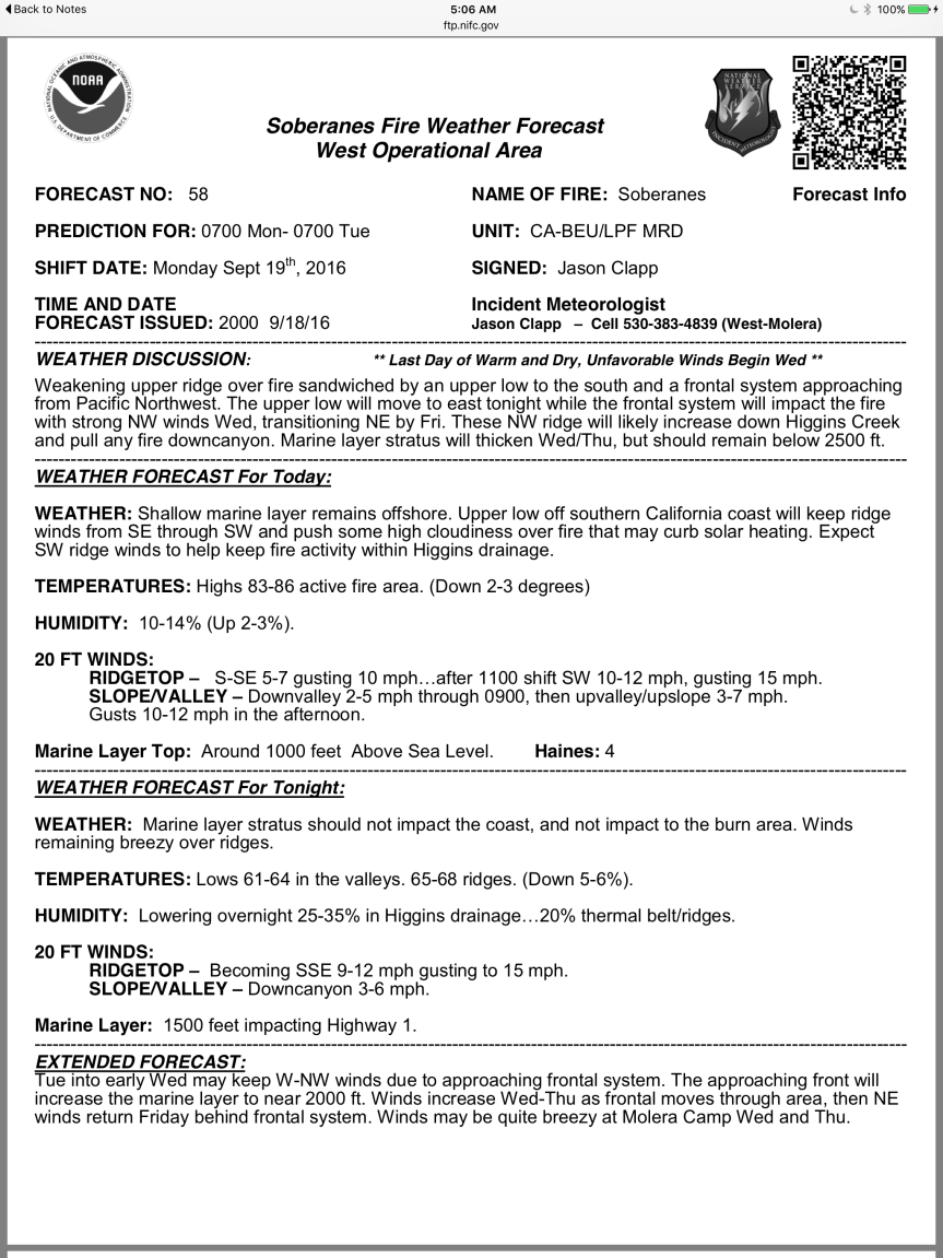
And here are the weather and fire behavior predictions for both sides of the fire:


Not to mention the most expensive fire to control in the history of forest fires in the U.S.A.
The devastation of wildlife is heart breaking and perhaps will have long lasting impact. Does anyone know if there is an investigation going on to identify the person who started the fire?
My sister, Nikki Nedeff, says the burned terrain will never be the same again.
But many of our fire adapted species – especially the trees – need fire to open up the cones for seed distribution, among other things. Clearing out the underbrush allows some rare and unusual wildflower species to appear that haven’t been seen in years. There are some advantages along with the devastation. As in almost everything in life, there are advantages and challenges. Winter will be a challenge.
bigsurkate
I don’t see the positive in this. It’s far too large to my small mind perhaps but the loss in wildlife alone is beyond comprehension, in their numbers and habitat . I still feel that we are sorely under equipped. Why do other
countries have large scooper planes in inventory to help put it out sooner rather than later ??? And the expense of this fire cannot possibly be justified in comparison to buying and having on hand some planes that can help.
As to the expense, wouldn’t some kind of patrols have been more cost effective than fire fighting. The county wants a seemingly endless number of visitors to come here but the larger the number of visitors the bigger chance there is of something like this happening.
Well, here is an ironic nature story. I’ve been watching this fire from Virginia for weeks, because I used to visit Chews Ridge in the early 1990s to see a rare butterfly, Speyeria adiaste clemencei, the Unsilvered Fritillary. They are not well fire adapted, feed on violets, and right now they are either in egg or tiny caterpillar form in the dead materials where violets will grow next spring. Chews Ridge is one of the last locations on earth where they are still found regularly. Seemed like they were spared from the fire, but then it was decided to burn out that entire ridge. Not sure it was necessary, but I’m hoping that isn’t the end of a subspecies.
Luckily, most of the main fire is now creeping along at a low intensity that will clear leaf litter, open cones, and leave the seeds and soil intact. It is the intense fire with the 20 foot flames and high heat that will kill the seeds, the soil microbes, and coat the soil particles with melted plant resins, making it unable to absorb moisture.
The smoke in Carmel Valley village is very thick. Rated unhealthy 184ppm-the large area back burning is more than what is necessary. Please send complaints to US Forest Service to help curtail the excessive back burning. Our children’s lungs (and our own) desperately need a break.
jsgray@fs.fed.us
soberanesfire2016@gmail.com (contact info from INCIweb)
Who is the regional/national environmental endangered species public incident commander for disasters of this kind and what can they offer when land/property are mostly the focus on most wildfire containments?
The Chews Ridge burn was heavy-handed with the single goal of putting as much black line on the map as fast as possible.
It has become an axiom that California coast range is “fire adapted”. However, Jon Keeley (and others) have documented when fire-frequency exceeds a baseline; bio-diversity, rare species, and habitat quality degrade.
Much of the Big Sur region represents a refuge of species that depend on long fire intervals and not frequent burns: for instance, Santa Lucia Fir. The current “burn out” may in the long run delay the reappearance of frequent fires, as it marks the creation of a long-desired continuous firebreak, and one that will be used (and maintained) in the future. Clearly, the fire interval in Big Sur appears to be accelerating, and this will accelerate the conversion of habitat types to more degraded forms. For the present, the burn-out seems somewhat gratuitous — as the natural fire to the west has ceased any forward progress weeks ago.
Overall, the advantages of the burn out need to be balanced against the risks. This means balancing a continuous N-S firebreak which may halt the spread of Carmel Valley fires (mostly human caused) with the risk of the present deliberate burn into wilderness (the pines in Pine Valley, butterflies, burning into the Santa Lucia Fir in the Escondido area.
CV Mom,
I was shocked to see Tularcitos School open despite these hazardous air readings. I have no idea to what degree bad air pollution has to be to close down a school district?
Tularcitos is not allowing students to play outside during recess.
I was surprised by that as well. The smoke is so thick that one cannot see across the valley. The Forest Service’s touted success of the back burn with the promise for more back burning operations, is making me very nervous for our kids as well as threatened species. Apparently, irrespective of the Soberanes fire, the US Forest Service has been wanting to do these burns for some time. While the need to control the fire progession is completely valid, the excessive back burning must be curtailed in the interest of public health & enviornmental health.
Great diversity in opinions here on what’s good for who and what. Thank you again, Kate, for this most rare forum of yours.
The fires produce a kind of oppressive hesitancy. Americans normally experience total freedom to proceed in any chosen direction and whereas we may stick a moistened fingertip to the wind to choose wisely, it’s unpleasant to feel directed by unmanageable forces.
We can certainly count ourselves lucky that the real damage only came early on, and when the troops were mustered –no more homes were burned. I read the stats here on this biggest and costliest of fires in the state’s history, and I’d say we’re doing okay. Whoever is picking and training the firefighters gets all my heartfelt thanks. They are so damn good. They’ve walked from their own safety and comfort of home, come from all over the world to help us out. And so far, despite resident’s exhaustion and cabin fever, they’ve gotten it right.
I agree that the back burning seems excessive…but at the same time, I am not a fire fighter, so I don’t know the details or reasoning of why they are doing such aggressive back burning. It seems like it started with the change of command…I hate that they keep changing who is “in charge” of the fire…and it astounds me that other fires start, get contained, and get put out rather quickly, while Soberanes just burns and burns and burns…and then you add a lot of aggressive back burning, an unhealthy amount of smoke, etc. and it adds up to a lot of frustration…and the lack of updates makes it even worse. Honestly, if it wasn’t for Kate we wouldn’t have the first clue what is happening in our own backyard. I am sick thinking of all the wildlife being displaced, not only by the main fire, but by all the back burning. I hate thinking what breathing all this smoke 24 hours a day is doing to my horses and my donkey.
FWIW weather.com has a 40% chance of showers for Monterey Thurs morning < .1 precip is expected, but, a change nonetheless. Does it make an impact at all?
Andrew, my professional NOAA app has 0% chance, as does John Lindsey in SLO. I can’t imagine if there IS rain that it will be enough to really do much to this fire. It has a mind of its own.
bigsurkate
10 day forecast typo, IDK?
https://weather.com/weather/tenday/l/USCA0724:1:US
The Soberanes Fire may be “good”, it may be “bad”…I am thinking it will end up as a little of both…hopefully more in balance than not. But I must say that my heart hurts for the loss of wildlife and habitat. I will not speak to the intense backburning as I am not there and have no knowledge of the reasoning. But I will say: I spent 30 years as a resident of the coast…living in Palo Colorado and on Gorda Mt and in many places in-between, and spent countless hours hiking the land, as well as living on it. I am not a scientist nor a professional wilderness expert, and I admit It is only my opinion, but it comes to me that the shear immensity of this fire , burning so large an area at once, and for so long will have a huge and long-lasting impact on the wilderness, both the burned areas and those surrounding it. I looked at that topo map posted above and my blood ran cold. I have a deep personal connection to the land there and feel this change viscerally. I guess I had hoped that the fire would somehow end up smaller than what it’s become.
I know that this is a time to stand strong and carry on with the fight, and to protect what can be protected and clean up and re-build what can’t. But I felt the need to voice the deep sadness I feel at the losses. To me, they are profound, and need to be grieved, both the human habitat loss and the wildlife loss.
Thank you, Kate, for having this place where us folks can share these feelings as well as the information. I appreciate it.
Kate,
I add myself to all who appreciate all that you have put into the blog to keep us informed. In the past days I’ve also much appreciated the voices in the comments of people who know the details of the back country and the various thoughts about our relationship to fire.
The varying views, knowledge, and opinions being shared in the comments section this last week has become one of the best things to come out of this whole mess. I so enjoy having my mind opened. Thank you, Steve.
As I said to another friend, though, when the first really good rains come, I will feel as if Christmas has arrived!!
bigsurkate
So miss the air I refer to as “Big Sur” in Cachagua. The Carmel River runs year round, the crickets were loud this weekend at the property were I help to create this defensible space, while giving up the privacy it brings, the feeling of breathing in nature. It’s a thankless job full of danger. Chased and trapped in vehicle by husky wolf dogs, mountain lion hiding on edge of property dodging the roar of Harley’s on Cachagua Road, a coiled snake between my red chicken boots( I could only throw up my arms screaming I know what that is, trapped on cliffside 2 foot path, one way out backwards). And I watch tirelessly as people get to enjoy the rocks basking in the sun and reflect how so many times I have read on this blog the abuse left behind by these people. Do they even care they are on private property?? I have filled recycled bins with the trash thrown out by cars driving along Cachagua Road, and a bucket full from where they bask this weekend. I am grateful for all I have learned from the Cal Fire websites creating defensible space. I an in awe of their efforts to fight through this dense forested terrain. Sometimes I can only clear out a 10 x 10 foot space. Sweatshirt on hoping I won’t get poison oak again. 85 to 95 degrees out. And again I am grateful for the pictures I get to see when I read this blog, the history I so appreciate to learn of this area I call home for the weekend. And I am reminded reading the rants and ravings that I am too a newby and learning everyday of what it means to live in the wilderness with fire as my neighbor. Sometimes I too think like when I was young, the sense of being unaware of the danger. Then looking back at what I did and thinking wow, That could of turned out bad. One of these days I might get the luxury of sitting on that rock and watch the river run by. Thank you nature.
One bit of fallout no one has mentioned so far is that CV road from the San Clemente construction entrance to Tassajara rd on up to the stand is getting beat to death…It’s not like it was great to start with and hard to think how it will be after wiinter. Hope the County gets some disaster $ to fix it, (and actually spends it for that…) Seems like back in the 80’s they resurfaced it every 2-3 years, been at least 10+ since they did anything more than a band aid.
Make a stink about getting it fixed as part of the BAER monies. I’m sure it qualifies.
bigsurkate
Tzila:
Nicely put. I think it expresses the sentiments of a lot of us.
Something must have happened today…they sent a local government strike team down there about 5:30 this afternoon…anyone hear anything ?
There was a tone out for a mixed LG Type III from Santa Cruz and Santa Clara. Some indication there is spotting on the east side of CVR per MODIS, which may or may not be accurate.
Forgot to mention that…Santa Cruz County Strike Team…
Carmel Valley Road is getting destroyed also. There was a huge patch looked like it was dug up by a tiller. Past the new payment a San Clemente Dam going towards Cachagua.
I love reading this blog, as opposed to some of the nasty comments that I see elsewhere. The entities fighting this fire are darned if they do and darned if they don’t. The actual firefighters are working there (*&^* off, leaving there homes and families. It bothers me to see them disrespected. Thank you Kate for all of your hard work and information. I am neutral here as I am not a fire fighter/manager, but it seems to me that when the fire was being left to burn there were complaints, then the back-burns… Now people are upset because they are “starting” the fires. The lands were burning, the wild life was being harmed and would be either way. Protect homes or protect wildlife and forest?
Let’s hope the MODIS reads are skewered. A whole new can of worms opens up if not.
I have felt helpless as I have sat here over two hours away from a distance from the fire and all of our beloved friends and of course our incredibly beloved Kate. On the news the other night, they reported how helpful the SPCA had been. I know all of us are concerned about the critters. I honor of that, I made a donation in thanks to the Monterey County SPCA thanking them for what they are doing. While our donation pales in comparison to what I know their needs are, it still made me feel like I was doing something, anything. God Bless you all and know that we are all pulling for all of you!
Tom Little Bear Nason
12 mins · Carmel Valley ·
The Fire jumped the Dozer lines over at Cahoon Ranch and is headed up Anastasia Canyon right up towards Tassajara RD and our Ranch and its raging out of control right now🔥⚠️🔥
It’s Burning fast and hit with winds up 40 mph!!!
Also, another of the Nason clan informed me within the last hour of a back burn at CVR and Cahoon’s.
bigsurkate
Late local newscasts have been slow- no news on breaking broken dozer lines.
Eyewitnesses are always faster than local news.
bigsurkate
Tom Little Bear Nelson has a FB presence is all I can find on the top social media spots. Unable to access not a fan of Zuck & co. Nonetheless, I hope he finds a safe space during this horrific turn of events.
Nason, good grief- spelling his proper name would help a great deal- why can’t I transpose correctly? Nothing recent on twitter – I see.
Evacuation warning has been issued for north of Carmel Valley Rd. from Hastings Reserve to the Cahoon Ranch. This one I received from reverse 911. I read in FB that there is a mandatory evacuation for Tassajara Rd. from Chews Ridge up toward the Nasons’ (Ventana Wilderness Expeditions).
Andrew..The Nason Family goes back a hundred or so years in the area…. His family owns, has owned properties in upper Carmel Valley ie. Nason Rd in Cachagua.