

7:15 pm – “These are the Zuni Firefighters from New Mexico..they are going around to each resident on East Carmel Valley Road several miles up from the Arroyo Seco Rd. intersection, to make sure there is enough defensible perimeters around structures to be protected in case the fire comes in..amazing how considerate they all are..Clybert is standing by the car…bless them for all their personal safety concerns and hard work..we all have evacuation warnings here..
Alva Ana Sargenti…East Carmel Valley Road…”


John Chesnut’s pm map:

Looks to have been more quiet than expected. Always welcome.
Great short video describing what happened last night and what is expected today here:
And for those of you who want to see the proper, ano very detailed group of weather forecasts for both sides of the fire go here: (too many for me to upload)
Weather matrix and discussions
This from Tassajara:
The fire is moving closer to Tassajara. There is large potential for a wind event beginning this afternoon into tomorrow morning, with gusts up to 30 to 40 mph from the NW. This is significant not only because of the high winds but also because of the direction, which topographically lines up with the Church Creek watershed to Tassajara. Many pairs of eyes are watching for this weather event.
Today (9/22), the ZMC Fire Brigade is preparing for the possibility of the Tassajara firing operation starting at around 12 PM. Depending on conditions however, it may start today, tomorrow, or the next day.
Also, remember the Monks have the Alpine Hotshot Crew with them to help this time.
Here is the trail map Big Sur Trail Map

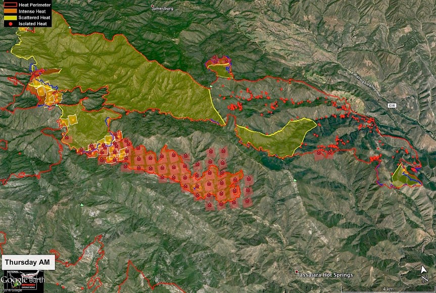
10:00 am – Here is John Chesnut’s map for this am, as well as the usual update by the USFS:
Daily Update: September 22, 2016 (this is the “Press Release”) – personally, the information found on inciweb is a bit more thorough, including weather predictions.
I would suggest visiting and bookmarking:
CONTACT:
Fire Information Line: (831) 204-0446 – Email: soberanesfire2016@gmail.com (Which has never answered me)
Current Size: 125,344 acres (88,150 acres CA-LPF; 37,194 acres CAL FIRE)
Containment: 71% Personnel: 2,302 Cause: Illegal campfire Injuries: 1 fatality, 7 injuries
Structures Destroyed:
57 homes, 11 outbuildings
Current Situation:
High winds with gusts as high as 35-40 mph are expected to continue through today. A dry cold front will create challenges in all areas of the Soberanes Fire, particularly along drainages that align with wind direction. Steep terrain and drought-stricken fuels increase the likelihood of difficult control efforts.
High winds overnight were counteracted by higher than expected relative humidity, limiting fire spread. Continued high winds are likely to increase intensity along the fire edges. The winds also will test the containment lines and could cause increased activity in seemingly dormant areas of the incident.
Firefighting efforts on Wednesday were focused on two spot fires burning outside primary containment lines. The spot fires were the result of wind-blown embers from within the containment lines. Neither spot fire expanded on Wednesday. Aggressive mop-up operations will continue today.
Line-building burnout operations, which were highly successful in recent days are largely on hold until weather conditions are more favorable. In the face of difficult conditions, efforts today will be to successfully hold established fire lines. In all cases and at all times, safety of firefighters and the public are paramount.
Evacuation orders and warnings remain in effect in the eastern areas of the fire. Information on evacuations is available at http://inciweb.nwcg.gov/incident/4888 (click on the Announcements tab).
Air monitoring is being conducted throughout the incident. Communities affected by drift smoke include Tassajara,Carmel Valley, Cachagua, and Arroyo Seco..
A community meeting is scheduled for 6 p.m. on Saturday, Sept. 24, at the fire station in Arroyo Seco, 46700 Arroyo Seco Road.
For more information, visit: http://inciweb.nwcg.gov/incident/4888/ or follow us on social media at http://www.facebook.com/LosPadresNationalForest or http://www.twitter.com/LosPadresNF.
Other contacts: SPCA, (831) 646-5534; American Red Cross, (831) 424-4824.
6:30 am – here’s one I haven’t seen before – an IR Operations Map:

5:00 am – And, one more time, ladies and gents … Another almost 2k acres added … For a total of 125, 230 acres …


And here are the morning’s fire behavior and weather prediction discussions:


Hi Kate, I looks like most of the above reports, if not all, are for yesterday, Sept 21.
from Intellicast.com:
Fire Weather Warning
CAZ517-222200-
/O.CON.KMTR.FW.W.0002.000000T0000Z-160923T0400Z/
SANTA LUCIA MOUNTAINS AND LOS PADRES NATIONAL FOREST-
355 AM PDT THU SEP 22 2016
…RED FLAG WARNING REMAINS IN EFFECT UNTIL 9 PM PDT THIS EVENING
FOR STRONG NORTHWEST WINDS FOR FIRE WEATHER ZONE 517…
* AFFECTED AREA…FIRE WEATHER ZONE 517 WHICH INCLUDES THE
SOBERANES WILDFIRE AND THE MONTEREY RANGER DISTRICT OF THE LOS
PADRES NATIONAL FOREST.
* WIND…WEST TO NORTHWEST WINDS 15-25 MPH WITH RIDGE LEVEL WIND
GUSTS FROM 35-40 MPH THROUGH THIS EVENING.
* HUMIDITY…GOOD RECOVERY BELOW 2000 FEET BUT CONTINUED VERY
DRY ABOVE 2500 FEET WITH HUMIDITY GENERALLY 20-30%
* HIGHEST THREAT…IS FOR ACTIVE FIRE AREAS ON THE SOBERANES FIRE.
NIGHT OPERATIONS WILL BE ADVERSELY IMPACTED WITH THE STRONGEST
WINDS EXPECTED DURING THE PRE-DAWN HOURS. EXCESSIVE SMOKE AND
STRONG WINDS WILL LIKELY IMPACT AIR OPERATIONS THIS MORNING.
* IMPACTS…ANY EXISTING AND NEW SPOT FIRES THAT DEVELOP WILL
LIKELY SPREAD RAPIDLY.
PRECAUTIONARY/PREPAREDNESS ACTIONS…
A RED FLAG WARNING MEANS THAT CRITICAL FIRE WEATHER CONDITIONS
ARE EITHER OCCURRING NOW…OR WILL SHORTLY. A COMBINATION OF
STRONG WINDS…LOW RELATIVE HUMIDITY…AND DROUGHT STRESSED FUELS
CAN CONTRIBUTE TO EXTREME FIRE BEHAVIOR.
The maps are dated today, with the IR flight occurring last evening, as usual, but the weather and fire behaviors discussions cover Weds and Thurs but are from today’s IAP. It appears they are the same or similar to yesterday’s.
bigsurkate
Yes, Regine, this same warning was issued yesterday and hasn’t changed. The red flag warning began yesterday at 3 and ends tonight at 9.
bigsurkate
Thank you Kate for getting all this to us!
If you look at the date on the weather forecast pages in today’s IAP, you will notice the information is for 0700 9/21/2016 to 0700 9/22/2016. Whoops! I can tell you that while the wind is similar, the weather today is very different than yesterday. About an hour ago we had virga rain in Kincannon Canyon. (That’s precipitation that does not reach the ground, dries in the air.) Didn’t have that yesterday. Microclimates! So while we still have the red flag warning, things are different meteorologically. It would be interesting to compare RAWS data from yesterday to today’s to see the differences as well as similarities.
It seems that large burn area east of the Tassajara Road is now. Is that part of the control burn?
I meant to say ‘new’, not ‘now’.
Winds much stronger from this time yesterday with overcast skies.
Howdy. I just called the information hotline. They have no report of new structure loss. They reported that the back firing operation in Pine Valley was successful and that the Caves Ranch and Zen Center are ready for the blaze.
Hi Crystal, I met Jack a couple of years ago at your moms house. He was a most amazing and lovable man. His face had clarity and innocence with all that love remaining for his wife.
Be well and my regards to your family.
Crystal, do you know ‘what’ they were backfiring in Pine Valley?
Crystal, it doesn’t sound like they have very updated information. I would hope that the caves is ready for the blaze since from the maps and other sources it burned through there yesterday. Regine they burned around Jack’s cabin in Pine Valley to make it more secure. Look at the incident map in this post it clearly got away from them and burned all of Pine Valley and down to the Caves.
And one more comment: on inciweb, you will see that “approx” in the Containment Date. Not sure if that was there before.
Maybe we are looking at October 31 next.
per bottom of Soberanes IAP page 8 of 68… (see last image above)
wise words there “Dave Berry”
a little humor? yeah – a little humor most needed on day 63
I see that … Odd place for humor, and odd piece of humor that.
bigsurkate
Hi Regine. He was a truly amazing man, full of love, wisdom, and adventure. From what I gathered they created an island around the structures with water and retardant then backfired from the lines in all directions to put as much black in Pine Valley as they could before the backburn from Chew’s burned through. The downside of this operation is that the backburn from Pine Valley made a run up to Church Creek divide and from what the maps are showing, down into the Caves Ranch. The cabin is safe but we won’t be sleeping easy until we know that the community as a whole is safe and this thing is out.
Even tho the fire is now moving closer to Tassajara, there are two hand crews, two pump engines, and a possible plan to backfire from Tassajara, in addition to the massive preparedness by the residents of Tassajara, so everything still looking good.
https://www.facebook.com/lospadresnationalforest/
Yes, the Alpine Hot shots are there with the monks and ready. I think they are in great shape.
bigsurkate
Just called Tass Zen center in Jamesburg. Fire is close and they are going to start the blackburn. Not sure where the backfire is starting from.
It is worthy to note that the impressive run made by the fire yesterday/last night originated in the English cabin area. A portion of the fire that has not moved for weeks and that was not a part of tactical burning operations conducted several days ago. This picture would have been much scarier without the deep buffer created by the firefighters. Thanks for all the detailed information and maps!
Firing operations at Tassajara are on hold as fire in Church Creek has “parked” for the moment. Lookouts and scouts have eyes on all trigger points. In addition to Alpine Hotshots, there are two National Fish and Wildlife Service Type 6 Fire Engine crews, and experienced fire veterans from California, New Mexico, Minnesota, and Colorado working with the Tassajara Fire Brigade. Rocky Oplinger’s California Incident Management Team 4 is totally committed to the protection of Tassajara.
Yay! Such good news. Continued thoughtful prayers for all of those holding this sacred place in balance.
bigsurkate
Kate — thank you so much for guiding us to the USFS video. It was fabulous, and informative, indeed. However, I’m not too pleased that we will be witnessing this monster for several more months!!!
Just had a flash, pun intended. It is not fire that is the monster, it is the ignorance or intend of the one that set it.
Thank you so much Kate!
It can’t be….someone needs to go to Sacramento and demand an end to it.
Pray for Rain.
Found it interesting if dispiriting to watch the briefing from the Ops Section Chief. He expects the fire to continue until the first major rains- typically November at the earliest. That implies that most of the remaining Ventana Wilderness that hasn’t burned will. I pray they find the idiots that started this and take off some hide. I love this area and feel for those of you that live around Big Sur.
Thank you, David, but most of us who live down here knew once it hit the Ventana there would be no stopping it until the rains came. This is not really new information to us. We’ve been here before.
bigsurkate
hello. just logging in for the day and wondering how the fire is doing around tassajara? mainly in response to joe’s comments from 12:05pm? that sounded like great news,
Kate,
OK, 21:00 is long gone what analytics have been found in this “Red Flag Warning” zone within other RFW’s Cal state wildfires of the past? Is there anything experts can learn from it?