


Photos from this weekend of: 1) Temporary Mesh Netting installed at Big Creek/Cow Cliffs (Sat-PM 28.5); 2) Rock fall at Lucia (Sun-PM 23); Rock fall at Paul’s (Sun-PM 26.10); and Partington Ridge (this am—PM 38.6)
***NEW INFORMATION***
The weekend’s inclement weather gave us various small slides at multiple locations, but thankfully and diligently, we have been able get the roadway clear and provide good news for tomorrow morning, weather permitting.
EFFECTIVE TOMORROW MORNING, TUESDAY, FEB. 7 AT 7 AM (WEATHER PERMITTING):
*DUE TO MORE SLIDE MATERIAL AT PAUL’S SLIDE (PM 21.6), All Motorists may travel north on Hwy. 1 from Cambria to Limekiln Creek Bridge (PM 21.3) or south on Hwy. 1 from Carmel to Lucia (PM 23).
*If you have been following our updates, you know we have dealt with various challenges, below is the status:
1) Mud Creek (PM 8.8)—continues with drilling taking place and daytime one-way traffic control (flagging). However, slide material continues to come down. Expect 20-30 minute delays.
2) The culvert has been replaced/repaired at PM 14.4 and is no longer covered with steel plates just north of Sand Dollar Beach (PM 13.85).
3) At Paul’s Slide (PM 21.6), although we have a temporary stop sign and eventually a traffic signal—MORE MATERIAL IS COMING DOWN AND THERE IS STILL A FULL CLOSURE AT PAUL’S. (see photo).
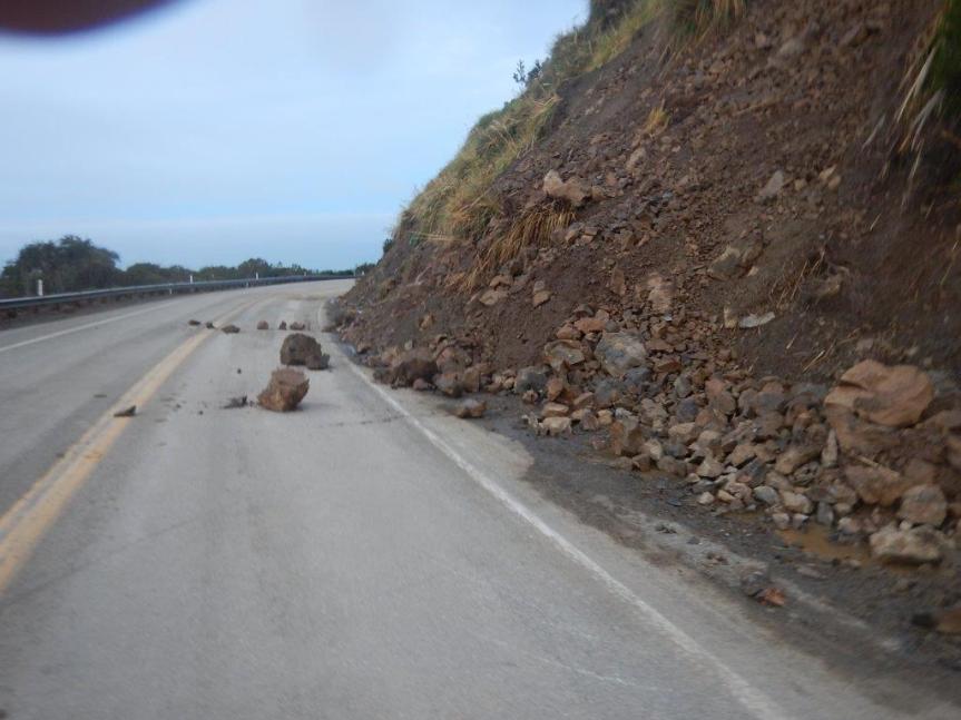
4) There was a small slide at Lucia (PM 23) this weekend, but has been cleared. (see photo)
5) Temporary mesh netting took place this Saturday at Big Creek/Cow Cliffs (PM 28.35), allowing the roadway to open at this location. (see photo)
6) There was a slide this morning at Partington Ridge (PM 38.6), necessitating the roadway to close at Fuller’s but has been cleared and will be open to traffic. (see photo).
The roadway is not passable between PAUL’S SLIDE (PM 21.6) and LUCIA (PM 23).
Thank you for your patience and understanding. Our Maintenance, Geotech and Construction crews continue to work collaboratively and diligently, as much as safely possible in response to these rock/mudslides.
Another update will be provided on around tomorrow, Tuesday, Feb. 7 afternoon, or sooner if conditions change.
Susana Z. Cruz nature-flower-blue-motif[1]
Caltrans District 5
Acting Manager
Public Information Office
Okay, changed it to conform, however my guess is mud will flow overnight with the rain. http://u.osmfr.org/m/122609/
JWC, thanks, but yes, this is a very “fluid” situation, and changing moment-to-moment and will rain expected all week, it will ramp up even more. This can’t be easy to do, but I’m sure everyone appreciates the work you are putting in on this – I know I do. Thank you.
bigsurkate
Will Palo Colorado turn into a raging mud/water debris flow once again?
I got information they were taking the temporary bridge down at 4:30 pm today, but have not been able to confirm.
bigsurkate
Fullers isnt a place please stop using it as a reference, it is a secret location and has nothing to do with anything you should be talking about like slides or location on the highway. Grimes point is a valid location but as far as fullers it isn’t something to use as a reference so please stop mentioning it thank you.
Fuller’s *is* a place, and it is the way Cal-Trans identifies it. I have tried to get it changed, but I can only publish it as they do, so call the District Office in SLO and ask to speak to the PIO.