

These were taken Saturday and Sunday by various people, including Inga Dorosz, Richard Wangoe, Connie McCoy, and Rock Knocker.
MUD CREEK:

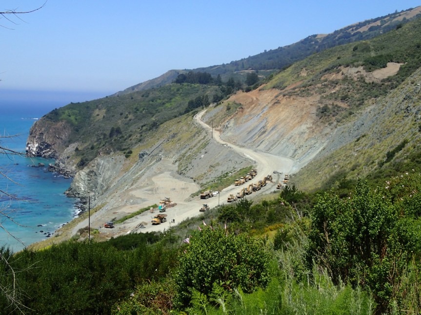
Inga Dorosz
Rock Knocker
PAUL’S SLIDE


Richard Wangoe


Connie McCoy
Rock Knocker
TECHNOLOGY – GADGETS


South Side of Mud Creek by Inga Dorosz

South Side of Paul’s Slide by Rock Knocker
Designed for open pit mining, you can read about this technology here (thanks to Inga Dorosz for the link):
BTW, many local residents reported almost constant flying of Mud Creek yesterday. Inga spoke with one CT guy on the ground and was told they were using LIDAR in the air and sending the info back to the GPS by his car. The Slope Monitoring Radar information will be sent via satellite to Colorado where it will be monitored in real time, once work begins again.
Thanks Kate. Your posts are so helpful to this ex-pat. I’ve a need to know what’s happening in my soul’s home, and you help…a bunch. Thanks.
Many thanks for the excellent photos…. Great work, even if the situation is rather disheartening. More reason than ever, especially for the businesses and residents in Big Sur south of Pfeiffer Canyon that a bypass road near the old temporary road that served perfectly well during the original bridge construction instead of the hiking trail should have been constructed.
Kate, if you needed any further affirmation of the importance of your posts to the Big Sur community, you would have seen it on the windows of the Barnyard Henry Miller Library yesterday at the grand opening party. In big print, and photos, attributed quotes from your blog helped explain the road situation to those attending.
How nice, Thanks.
bigsurkate
Paul’s Slide is just hanging on by a thread.
Wonderful photo work- everybody.
RK is gonna stay in good shape moving up & down that slope. 🙂
As I looked at these pictures, I could hear a booming voice saying “D-O-N-‘T M-E-S-S W-I-T-H M-E,” but I have to admit the technology is pretty damned impressive.
In the upper of the two pictures I took of Pauls look for a crack on the inside, about 20 + yards long, left to right.
On the lower picture look for a crack running lower left to upper right just this side of the base of the ramp onto the bench where they are distributing the cut material.
Both cracks are fairly well centered in the pictures.
cracks are indicative of movement….
hope that helps folks understand.
Thanks, Richard
Hi Kate, I tried to leave a comment on your blog today twice, and it never appeared. Am I doing something wrong? It’s the same basic comment about addressing and limiting numbers in addition to education, signage, etc. I thought I was pretty tech wise… I don’t care how it gets transmitted, my point is I think more people are open to the idea of a toll road on Hwy 1 MOCO.
Hope you’re doing as well as possible.
Cheers, Patricia
Patricia, well this one got posted. So Cheers.
https://bigsurkate.blog