


7:50 pm — Due to the River Fire encroaching on the command post located at Toro Park in Salinas, CAL FIRE Incident Management Team 1 has initiated plans to relocate all non-essential personnel. Essential personnel remain at the incident command post to manage the River and Carmel Fires.
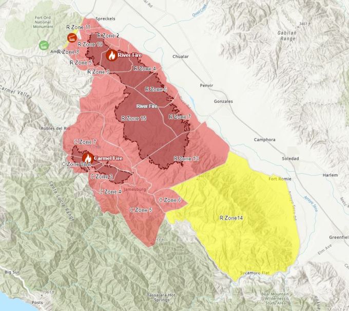
Evacuation Map as of 3:25 PM:
2:24 PM: KSBW reporting backburn operations underway at Indian Springs.

Update on Fires in Monterey County 10:16 AM: River Fire 33,653 Acres – 7% contained, Carmel Fire 4,285 Acres – 0% contained, Dolan Fire 2,500 Acres – 0% contained. More info: https://www.facebook.com/MontereyCountyOES
River Fire – Evacuation Order for Corral De Tierra south to Tassajara Rd. 9:40 AM: The Monterey County Sheriff’s Office has issued an Evacuation Order for all areas south of Corral de Tierra Road and Underwood Road extending south to Tassajara Rd, not to include Corral de Tierra Road and Underwood Road.
River Fire – Zone 13 Evacuation Order Overnight 9:22 AM: Over night the Monterey County Sheriff’s Office deputies issued in person evacuation orders for areas West of River Road extending west to Carmel Valley Road. West of River Road south from Gonzales River Road to Puma Road. East of Carmel Valley Road from south of Tassajara Road to Finch Creek.
River Fire – Evacuation Warning from River Road to Arroyo Seco 9:02 AM: The Monterey County Sheriff’s Office has issued an Evacuation Warning for all areas east of Carmel Valley Road extending south from finch Creek to Arroyo Seco Rd. All areas west of River Road and For Romie Road and Arroyo Seco Road extending South to Elm Avenue and Arroyo Seco Rd.
11 am — from the office of Mary Adams:
Update #RiverFire – 33,653 Acres, 7% Containment
Fire continues to actively burn in all directions. Progression to the north impacted homes in the outlying communities of Salinas. The fire is making slope driven runs.
Firefighters continued their aggressive attack on the fire from the ground and the air. High temperatures, low humidity, topography influenced winds, steep mountainous terrain and difficult access continue to hamper firefighting efforts. Firefighters continue with 24 hour a day operations.
Wind patterns differ on each side of the fire, which contributes to the spread of the fire in multiple directions.
For more details, see pictures or go to https://www.fire.ca.gov/incidents/2020/8/16/river-fire/
Please register for evacuation alerts by visiting http://AlertMontereyCounty.org.
For information on how you can prepare for wildfire please visit http://www.ReadyForWildfire.org or fire.ca.gov
For information regarding the Dolan Fire, please visit fire.ca.gov or inciweb.NWCG.gov
7:00 AM this page will be updated throughout the day. Check back for more updates.
33,653 Acres, 7% Containment
CalFire Incident page here & Facebook Updates here. Sheriff Facebook Updates here.


River and Carmel Fires Google Earth Image with VIIRS and MODIS Satellite and CDF Infrared combined. Some of the latest detections are from 10:48 UTC (3:48 AM PT, see Important caveats note below). Click this link to view larger image: River_Carmel_Fire_082020

Toro view: River_Carmel_Fire_Toro_082020

Palo Escrito Peak view: River_Carmel_Fire_Escrito_082020

From John Chesnut:

River Ortho Map (click on map to view full size):

River Topo Map (click on map to view full size):

Daily IR Log here
National interagency Fire Center Map can be found here
Evacuation Map can be found here (Red is Order, Yellow is Warning)
Evacuation Notifications can be found here
Current Wind can be found here
Alert Wildfire Camera here
Air Traffic here
Road Closures here
CalFire’s Ready, Set, Go! Checklist here (see page 9)
Important caveats: Please note that the squares on the heat detection maps represent the expected margin of error, not the size of the area burned. In other words, the detection could have come from anywhere within the square. Also be aware that false detections do sometimes occur. An outlying or “over the line” heat detection is not, by itself, a confirmation that there is fire in the area indicated. In addition, the satellites do not detect heat everywhere that fire exists. Creeping, backing or smoldering fire is often not detected. Finally, the detections are only snapshots of moments in time. Flare ups that occur before or after a satellite pass may be entirely missed.
Also be aware that yellow squares disappear from the map after 6 days. These are not maps of the area burned since the fire began, just maps of where heat has been detected during the past week.
Thank-you for the great collection of information and sources. Usually I’m on the outside looking in but not this time. 🙁
Knowing where to turn for valid data is such a great load off my mind and definitely helps my far away family.
Thanks again
Dear Ms. Kate,
Thank you so much for this site! We have family on the cusp of Ordered Evacuations and all of the information you have provided is not only very helpful but also gives us something to fill our time while we wait to see how the fires are going to behave and what the scenarios will be for the day.
Thank You!
You are welcome, Denise.
You are welcome
3pm, 8-21: just began seeing helicopters taking water the River Fire at the Toro regional park area. (I’m in CDT)
And can hear a low flying plane to the south that is likely dropping fire retardant. Thank goodness for clearer skys today.