To give you an idea of where the Soberanes Fire is burning, we’ve included maps that are updated daily. These maps are provided by Cal Fire/US Forest Service.
The latest Heat Perimeter was not updated today as of 7:10 am. You can see yesterday’s Heat Perimeter on the Infrared Topo and Infrared Ortho maps. Note: The Heat Perimeter is not current on any other Official Map.
We’ve also included the Weather Forecast, Fire Behavior Forecast and various links that you may find useful. Note: Additional links are located at the end of the post. Some links may open large PDF documents.
Please see Local Reports for the current fire discussion.
Infrared Topo: IR_Topo (not current)
Infrared with Satellite Image: IR_Ortho (not current)
IR Log (not yet released)
Weather Forecast
Fire Behavior Forecast
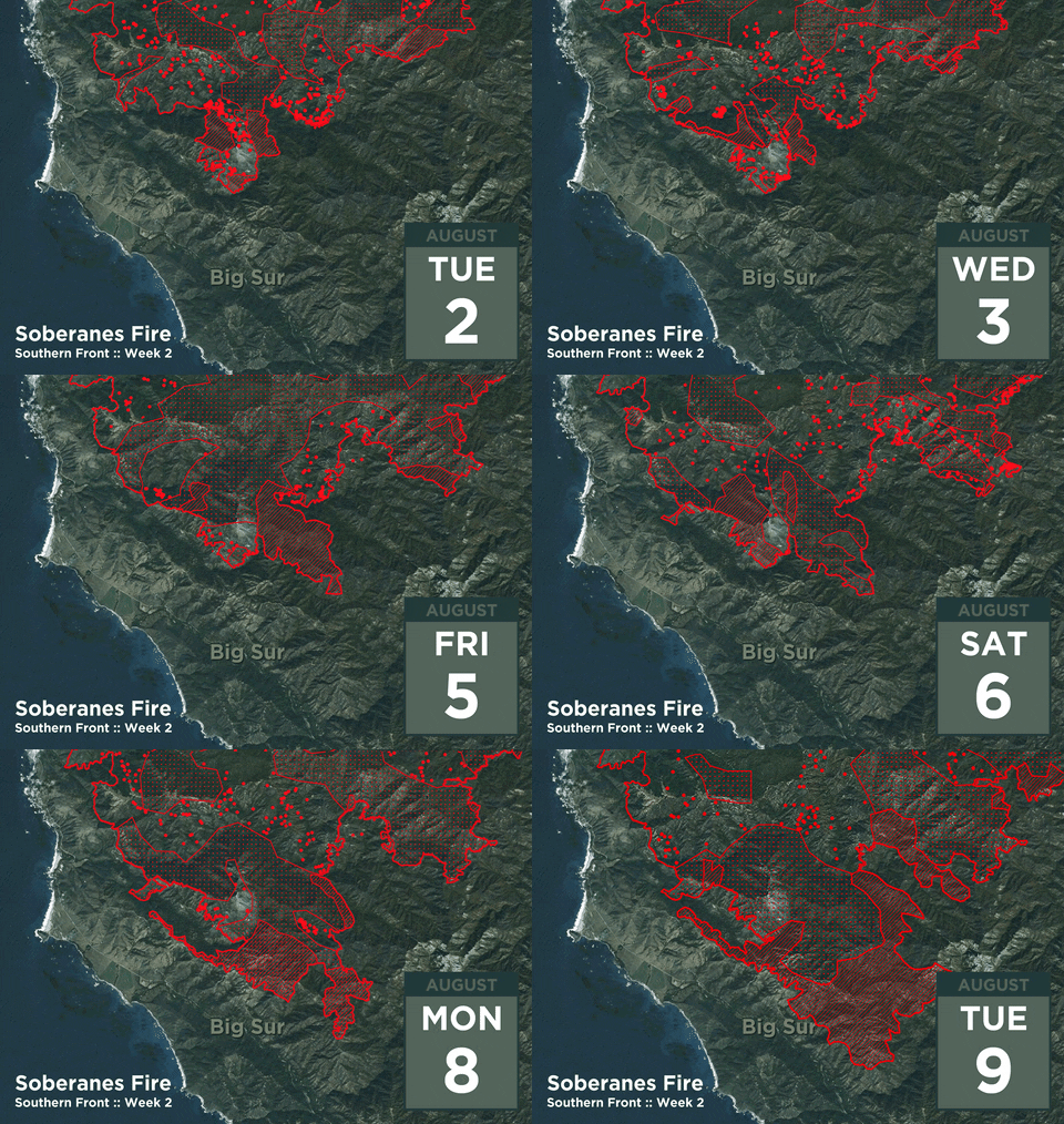
GIF animation of the fire’s southern front from August 2nd to August 9th (provided by Dirk Reynolds):
Tuesday’s IR flight overlaid on Google Earth with today’s VIIRS satellite data from 2:34 am (provided by John Chesnut). These show the hot spot to be flanks of Ventana Double cone. As always, please remember that false readings do occur.
Operations Map North: Ops North
Operations Map South: Ops South
Legend
Briefing Map: BAM
Progression Map: Progression Map
Links:
Xasauan Today Satellite heat detection discussion
Google Maps (not current IR) Adam Clark’s Google Map with most recent Dozer lines, IR flight overlay, and the Planned Fire Line. Note: You may need to be signed in to a Google account to view this link.
Mapping Support (not current IR) Same as above, but on USGS Topo Maps
MesoWest Weather stations that are located near the fire. Scroll down to S07 Central Coast IRAWS. See the Blue WX rectangles on the Ops maps for locations. There are currently 7 portable weather stations deployed.
Flight Radar 24 Live Air Traffic for the area. Note: aircraft flying at low altitudes may not be detected.
Additional Cal Fire/ US Forest Service Links:
INCIDENT PLAN Complete Incident Plan as of 8/10/16. Note: PDF may take awhile to download
PUBLIC INFORMATION MAP as of 8/10/16
IAP MAP CARMEL Dozer Carmel (not current) as of 8/10/16
IAP MAP SECO Dozer Seco (not current) as of 8/10/16
IAP MAP SUR Dozer Sur (not current) as of 8/10/16
Air Operations Map Air Ops (not current) as of 8/10/16
Air Operations HELCO Map HELCO (not current) as of 8/6/16
Firefighting Aircraft PDF guide with Cal Fire Firefighting Aircraft
SITUATION Situation Map (not current) as of 8/2/16 shows previous fire outlines
ELEVATIONS Elevations Map (not current) as of 8/2/16 shows hills and valleys in various colors
NO Kings: Vote Early! Rally in Monterey, Saturday, October 17, 2-4 pm at Window on…
Community Information from Supervisor Kate Daniels: To prepare for upcoming winter weather, Supervisor Daniels will…
Date: Tuesday, October 13, 2026 District: 05 – Santa Barbara, San Luis Obispo, Monterey, San Benito, and…
I think my mother, god bless her, saved this for my daughter who was born…
This website uses cookies.
View Comments
many, many thanks to all who are contributing!