Loma Fire, 9/29/16

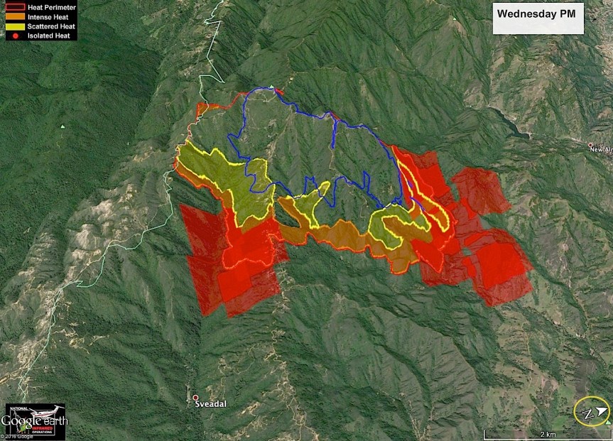
John Chesnut Map; note North is rotated.

image

This fire is now expected to be contained by October 3, 2016. Absent any unusual events, I will only be posting John’s maps, if available, on this fire.

Loma Fire Incident Information:
Last Updated: September 29, 2016 6:30 am
Date/Time Started: September 26,2016 2:42 pm
Administrative Unit: CAL FIRE Santa Clara Unit
County: Santa Clara County
Location: off Loma Prieta Rd and Loma Chiquita Rd 10 miles NW of Morgan Hill
Acres Burned – Containment: 3,849 acres – 22% contained
Structures Threatened: 325
Structures Destroyed: 1 single residence and 6 outbuildings destroyed, 1 single residence damaged
Evacuations: Santa Clara County: Mandatory evacuation orders for the Loma Prieta ridgeline area including all tributary roads along Summit Road from Soquel San Jose Road to Ormsby Fire Station. This includes Uvas Canyon County Park, Loma Chiquita, Casa Loma, and Loma Prieta Way. Portions of Croy Road are under an evacuation warning.
Santa Cruz County: All evacuation orders and warnings have been lifted. Evacuation alerts in Santa Clara County can be received by signing up for AlertSCC, visit: http://www.sccgov.org/sites/alertscc/Pages/home.aspx.

Evacuation Centers: Santa Cruz County Fairgrounds, 2601 East Lake Ave, Watsonville (large animals welcome)
Jewish Community Center of Silicon Valley, 14855 Oka Road, Los Gatos
Morgan Hill Presbyterian Church, 16970 De Witt Avenue, Morgan Hill

Road Closures: Loma Chiquita Road, Summit Road from Soquel San Jose Road to Pole Line Road, Mount Bache Road at Highland Road, Casa Loma Road at McKean/Uvas, Mount Madonna at Ormsby Road Mount Madonna Road at Pole Line Road, Croy Road at Uvas Road is open to residents only
Cause: Under investigation

Loma Fire, 9/28/16

Here is the evening John Chesnut Map of the Loma Fire. We got a two-headed monster going, now. Note that North is rotated to be on the right of the map.

image

John Chesnut MAP

image

Here is today’s Topo IR map and the daily update. Today is a town run day for me, so won’t be available much of the day.

image

IR Topo Map in PDF
Last Modified on September 28,2016
LOMA FIRE

Loma Fire Incident Information:
Last Updated: September 28, 2016 6:30 am
Date/Time Started: September 26,2016 3:06 pm
Administrative Unit: CAL FIRE Santa Clara Unit
County: Santa Clara County
Location: off Loma Prieta Rd and Loma Chiquita Rd 10 miles NW of Morgan Hill
Acres Burned – Containment: 2,250 acres – 10% contained
Structures Threatened: 300
Structures Destroyed: 1 single residence and 6 outbuildings destroyed, 1 single residence damaged
Evacuations: Mandatory evacuation orders for the Loma Prieta ridgeline area including all tributary roads along Summit Road from Soquel San Jose Road to Ormsby Fire Station. This includes Uvas Canyon County Park, Loma Chiquita, Casa Loma, Loma Prieta Way, Highland Road and Mount Bache Road. Portions of Croy Road are under an evacuation warning.
Reverse 911 calls have also been sent to residents using Alert SCC. If you have not already signed up for AlertSCC visit http://www.sccgov.org/sites/alertscc/Pages/home.aspx.

Evacuation Centers: Santa Cruz County Fairgrounds, 2601 East Lake Ave, Watsonville (large animals welcome)
Jewish Community Center of Silicon Valley, 14855 Oka Road, Los Gatos
Morgan Hill Presbyterian Church, 16970 De Witt Avenue, Morgan Hill

Road Closures: Loma Chiquita Road, Summit Road from Soquel San Jose Road to Pole Line Road, Mount Bache Road at Highland Road, Casa Loma Road at McKean/Uvas, Mount Madonna at Ormsby Road Mount Madonna Road at Pole Line Road, Croy Road at Uvas Road is open to residents only
Cause: Under investigation
Cooperating Agencies: California Highway Patrol, Santa Clara County Sheriff’s Office, Santa Cruz County Sherriff’s Office, California Department of Corrections and Rehabilitation, San Jose Water Company, Santa Clara Valley Water District, Pacific Gas and Electric and Santa Clara County Office of Emergency Services.

Loma Fire, 9/27/16

6:30 pm report (posted at 7, I was busy with the fur kids_

September 27, 2016 6:30 pm
Date/Time Started: September 26,2016 3:06 pm
Administrative Unit: CAL FIRE Santa Clara Unit
County: Santa Clara County
Location: off Loma Prieta Rd and Loma Chiquita Rd 10 miles NW of Morgan Hill
Acres Burned – Containment: 2,250 acres – 10% contained
Structures Threatened: 300
Structures Destroyed: 1 single residence and 6 outbuildings destroyed, 1 single residence damaged
Evacuations: Mandatory evacuation orders for the Loma Prieta ridgeline area including all tributary roads along Summit Road from Soquel San Jose Road to Ormsby Fire Station. This includes Uvas Canyon County Park, Loma Chiquita, Casa Loma, Loma Prieta Way, Highland Road and Mount Bache Road. Portions of Croy Road are under an evacuation warning.
Reverse 911 calls have also been sent to residents using Alert SCC. If you have not already signed up for AlertSCC visit http://www.sccgov.org/sites/alertscc/Pages/home.aspx.

Evacuation Centers: Santa Cruz County Fairgrounds, 2601 East Lake Ave, Watsonville (large animals welcome)
Jewish Community Center of Silicon Valley, 14855 Oka Road, Los Gatos
Morgan Hill Presbyterian Church, 16970 De Witt Avenue, Morgan Hill

8:45 am – estimate is 1500 acres with 5% containment. (Estimate is way too high, Cal Fire reports 1085 acres)  Here is a good link for info:

Cal Fire incident

John Chesnut did up a “bonus” map for us of the Loma Fire, in addition to the Soberanes Fire. Note on this one that North has been rotated in order to provide a regional frame of reference:

image

While I won’t be following this fire as I have the Soberanes, I will put up this new post for others to share information in the comments section. The following photo is by Cal Fire PIO, and is a very sad testament to this fire’s destruction.

image