

Dolan Fire Burn Scar is now in the high risk category. From NWS:
⚠️Portions of coastal-central California have been upgraded to a HIGH risk of excessive rainfall through early tomorrow morning. Continued heavy rainfall over burn scar areas is producing life-threatening flooding and debris flows. #CAwx
More info here: wpc.ncep.noaa.gov/discussions/hp…

Mud flow at MM 27. Photo by Mark Readdie of Big Creek
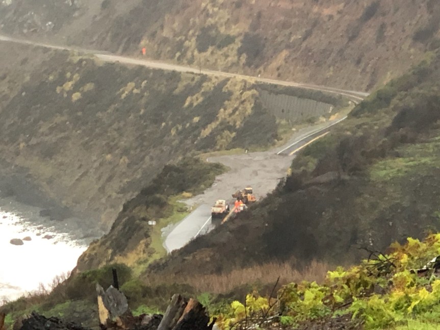
9:15 am— I am a little late with this one. MM 35 is Anderson Canyon
Incident: 00137 Type: Road/Weather Conditions Location: 3500 Mm1 N Mon 35.00 Loc Desc: Lat/Lon: 36.149374 -121.661950
| Detail Information | ||
| 8:27 AM | 12 | [20] AND CLOSURE STILL IN EFFECT FROM LAST NIGHT MM 42 TO JSO THE COUNTY LINE PER 12 |
| 8:27 AM | 11 | [19] 1039 STATE PARKS |
| 8:25 AM | 10 | [18] CALTRANS HAS EQUIP IN AREA / WILL ATTEMPT TO CLEAR AT LEAST ONE LANE / ADV STATE PARKS -THEY HAVE RANGER ON SOUTH SIDE OF SLIDE |
| 8:00 AM | 9 | [16] HAS LOADER AND TK ENRT TO CLR RDWY / UNK ETA |
| 7:59 AM | 8 | [15] [Notification] [CHP]-DOT LL / SUPERVISOR ETA 0900 |
| 7:57 AM | 7 | [13] 1039 DOT , DOT ADVISED SPVSR SHOULD BE 97 AT CALTRANS BIG SUR STN |
| 7:55 AM | 6 | [9] THIS IS WITHIN CLOSURE ESTABLISHED YESTERDAY |
| 7:53 AM | 5 | [8] 1039 SLO COMM TO ALSO ADV IF THEY HAVE ANY AREAS CLOSED |
| 7:53 AM | 4 | [7] PER 27-S1 NTFY SLO CHP, 1039 |
| 7:51 AM | 3 | [5] 1039 27-S1 VIA LLINE |
| 7:50 AM | 2 | [4] 1039 MTRY COM |
| 7:50 AM | 1 | [1] COMPLETE 1125 /MUD SLIDE / NO PASSABLE BY EMERG VEHS / |
| Unit Information | ||
| 7:50 AM | 3 | Unit At Scene |
| 7:50 AM | 2 | Unit Enroute |
| 7:50 AM | 1 | Unit Assigned |
7:15 am — for any of you asking on FB, twitter, or here about slides, debris flows, etc. The highway is closed and most of my friends are smart enough not to get out there to look, so I have no information. IF I do get a report from a friend, Cal Trans or MoCo, I will post it here first.
10-15” expected in my neck of the woods in the next 48 hours:

6:30 am — Chalk Peak got .67” of rain in the last hour:

6:30 — rain continues, heavy at times, but no more lightning, thankfully. John Lindsey reported about 4:30 this am: “The area of white over the Central Coast represents 6+ inches of rainfall in the next 24-hours. The #ECMWF has increased the size of the 6+ area, while the #GFS has kept it the same since the last model runs. These numbers are literally off the scale.”

5:15 am — At approximately 4:30 am the frontal band (I am assuming that’s what it was) came through here with a vengeance, The thunder & lightning were simultaneous and the doggos, particularly my BC were out of their skins and shaking so bad, trying to find a place to hide, preferably inside me. There was no going back to sleep after that performance. So it was up, get the generator started, coffee made, and fire stoked from last night. I suspect it will be a long day. Also, my satellite internet seems to be in and out, but mostly in at the moment. We are in a bit of calm at the moment. I’ll keep this post open and running all day and add to it as indicated,

| Detail Information | ||
| 4:25 AM | 3 | [3] DUE TO FLOODING and MUD DEBRIS |
| 4:24 AM | 2 | [2] NB RIVER RD CLOSED AT CHUALAR RIVER RD |
| 4:24 AM | 1 | [1] SB RIVER RD CLOSED AT PARKER RD |


