MONTEREY and SAN LUIS OBISPO COUNTIES – A full closure of Highway 1 on the Big Sur Coast will now remain in effect through Friday Jan. 29. The extension of this closure is in support of ongoing evacuations that are expected to continue into Thursday and Friday this week and to assess damage from this week’s rainstorm.
This closure extends from Ragged Point in San Luis Obispo County to just south of Deetjen’s Big Sur Inn in Monterey County (44.6 miles). The closure began on Tuesday Jan. 26, at 5 pm.
Monterey County has issued an Evacuation Order for areas downslope of the Dolan Fire burn scar where this storm brings an increased likelihood of debris flows.
Caltrans is working with local agencies to minimize travel into Big Sur to allow residents and businesses to evacuate in the safest conditions possible.
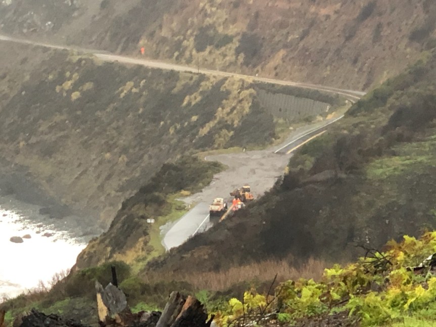
There are several areas of moderate damage, rockfall, and mudflows on Highway 1 inside the closure. Significant rain is expected this evening and the overnight hours.
Assessments are expected to take place Friday morning, Jan. 29, prior to any decision about a possible reopening of the highway or modifications to the highway closure.
More information will be known following these assessments and an update will be provided Friday afternoon.
NOTE: I am still updating and adding information to the general storm report today, the post after this one.
More photos of Mill Creek sent to me by Ge but unknown who took them
All these photos were take by Adalaine Long and Susan Cappell Gutberlet of Plaskett Creek Campgrounds.
Directly below the Mill Creek Bridge on Highway One
Per Susan on above photos: “Up creek I can see Mill Creek Ranch Road. Cleared the creek all the way up to Gi’s place.
The one with the mysterious ladder is facing Southbound HWY 1.
One photo shows the stairways from the parking lot to the lower level picnic area now stairs to nowhere. Tables and BBQ grills are gone…washed into the sea.
All that is left is literally the parking area.”
Ge sent me this one, it was taken by Wade of Cal Trans. He contacted me this morning saying he and his family left yesterday afternoon and asked to me to let people know they were okay.
Dolan Fire Burn Scar is now in the high risk category. From NWS:
⚠️Portions of coastal-central California have been upgraded to a HIGH risk of excessive rainfall through early tomorrow morning. Continued heavy rainfall over burn scar areas is producing life-threatening flooding and debris flows. #CAwx
More info here: wpc.ncep.noaa.gov/discussions/hp…
Mud flow at MM 27. Photo by Mark Readdie of Big Creek
9:15 am— I am a little late with this one. MM 35 is Anderson Canyon
Incident: 00137 Type: Road/Weather Conditions Location: 3500 Mm1 N Mon 35.00 Loc Desc: Lat/Lon: 36.149374 -121.661950
Detail Information
8:27 AM
12
[20] AND CLOSURE STILL IN EFFECT FROM LAST NIGHT MM 42 TO JSO THE COUNTY LINE PER 12
8:27 AM
11
[19] 1039 STATE PARKS
8:25 AM
10
[18] CALTRANS HAS EQUIP IN AREA / WILL ATTEMPT TO CLEAR AT LEAST ONE LANE / ADV STATE PARKS -THEY HAVE RANGER ON SOUTH SIDE OF SLIDE
8:00 AM
9
[16] HAS LOADER AND TK ENRT TO CLR RDWY / UNK ETA
7:59 AM
8
[15] [Notification] [CHP]-DOT LL / SUPERVISOR ETA 0900
7:57 AM
7
[13] 1039 DOT , DOT ADVISED SPVSR SHOULD BE 97 AT CALTRANS BIG SUR STN
7:55 AM
6
[9] THIS IS WITHIN CLOSURE ESTABLISHED YESTERDAY
7:53 AM
5
[8] 1039 SLO COMM TO ALSO ADV IF THEY HAVE ANY AREAS CLOSED
7:53 AM
4
[7] PER 27-S1 NTFY SLO CHP, 1039
7:51 AM
3
[5] 1039 27-S1 VIA LLINE
7:50 AM
2
[4] 1039 MTRY COM
7:50 AM
1
[1] COMPLETE 1125 /MUD SLIDE / NO PASSABLE BY EMERG VEHS /
Unit Information
7:50 AM
3
Unit At Scene
7:50 AM
2
Unit Enroute
7:50 AM
1
Unit Assigned
7:15 am — for any of you asking on FB, twitter, or here about slides, debris flows, etc. The highway is closed and most of my friends are smart enough not to get out there to look, so I have no information. IF I do get a report from a friend, Cal Trans or MoCo, I will post it here first.
10-15” expected in my neck of the woods in the next 48 hours:
6:30 am — Chalk Peak got .67” of rain in the last hour:
6:30 — rain continues, heavy at times, but no more lightning, thankfully. John Lindsey reported about 4:30 this am: “The area of white over the Central Coast represents 6+ inches of rainfall in the next 24-hours. The #ECMWF has increased the size of the 6+ area, while the #GFS has kept it the same since the last model runs. These numbers are literally off the scale.”
5:15 am — At approximately 4:30 am the frontal band (I am assuming that’s what it was) came through here with a vengeance, The thunder & lightning were simultaneous and the doggos, particularly my BC were out of their skins and shaking so bad, trying to find a place to hide, preferably inside me. There was no going back to sleep after that performance. So it was up, get the generator started, coffee made, and fire stoked from last night. I suspect it will be a long day. Also, my satellite internet seems to be in and out, but mostly in at the moment. We are in a bit of calm at the moment. I’ll keep this post open and running all day and add to it as indicated,
HIGHWAY 1 ON THE BIG SUR COAST TO CLOSE TUESDAY IN SUPPORT OF MONTEREY COUNTY EVACUATION EFFORTS
MONTEREY and SAN LUIS OBISPO COUNTIES – Highway 1 on the Big Sur Coast will be closed between Ragged Point in San Luis Obispo County and Deetjen’s Big Sur Inn in Monterey County (44.6 miles) beginning Tuesday Jan. 26 at 5 pm.
This closure on Highway 1 is expected to remain in effect until Thursday, Jan. 28. Assessments will take place, during daylight hours and when safe to do so, prior to reopening of the highway.
A major rainstorm is expected to advance on the Monterey Bay area late Tuesday night into early Wednesday morning. High winds also pose the potential for downed trees and power lines.
Monterey County has issued an Evacuation Warning for areas downslope of the Dolan Fire burn scar where this storm brings an increased likelihood of debris flows.
Caltrans is working with local agencies to minimize travel into Big Sur to allow residents and businesses to evacuate in the safest conditions possible.
This evacuation closure of Highway 1 comes at the request of the California Highway Patrol and in support of Monterey County’s Evacuation Warning.
Ragged Point is located 1.45 miles south of the SLO/Monterey County line:
Barricades, cones, as well as message and directional signs will be in place at both ends of the closure to alert motorists traveling in the area.
First off, I haven’t heard from Cal Trans on where they are closing highway 1, yet, but will add it right up at top of this post when I do. Secondly, this bull’s-eye on Big Sur is eye-popping, mouth-opening crazy. Some reports are that it will be sticking around for 20 hours or so, which is why rain amounts are so astronomical. Another report I read this am is that it is expected to arrive tonight, around midnight.
From Daniel Swain: “Then, on Wednesday, the #AtmosphericRiver/associated cold frontal rainband will likely stall along Central Coast (near border of Monterey/SLO counties). High-res models are suggesting potential for extreme 48hr rainfall accums, & very high flood/mudslide risk there.”
“The Hwy corridor and Big Sur, as well as the Dolan/River Fire footprints, appear to be at very high risk in this scenario. Other models aren’t quite as aggressive with rainfall totals here, but still suggest a high likelihood of 10-15 inches.”
PLEASE NOTE THAT THE MAXIMUM LISTED AT THE UPPER RIGHT CORNER IS 23.3 INCH.
Due to the upcoming atmospheric river and high likelihood for debris flows, parts of State Route 1 in Big Sur will be closed with barricades and signs beginning at 5:00PM on Tues, January 26 and is expected to remain closed until Thur, January 28. More info tomorrow.@CaltransD5
Evacuation Warning Issued for Carmel, River and Dolan Fire Burn Scar Areas
CLARIFICATION FROM MCSO: If you are not living in close proximity to a burn scar, you may have received a message in error. If you are unsure if you are in an evacuation zone visit the evacuation map: https://bit.ly/2MpXkgU
WHEN: Effective January 25th at 4:00 p.m.
WHERE: Carmel, River and Dolan Fires burn scar areas
WHAT: The Monterey County Sheriff’s Office has issued an Evacuation Warning for areas within and two miles downslope of the Carmel Fire, River Fire, and Dolan Fire burn scars due to the upcoming atmospheric river and the high likelihood for debris flows. There is also currently a Flash Flood Watch in place.
The Evacuation Warning will take effect Monday. January 25th at 4:00 p.m.
This warning is being given well in advance of our incoming storm system due to anticipated rainfall. Beginning late Tuesday night into early Wednesday morning, the US National Weather Service San Francisco Bay Area/Monterey California is predicting 8 to 10 inches of rain over the course of the storm in the Santa Lucia Mountains and Los Padres National Forest in Monterey County, which would impact all wildfire burn scar areas.
The Evacuation Warning that will be in place will be upgraded to an Evacuation Order if the Flash Flood Watch in place upgrades to a Flash Flood Warning, but those who live in dangerous areas are highly encouraged to consider leaving sooner for their safety. Due to heavy winds, those who need to leave one of the impacted areas could find exit routes impassable. Once an Evacuation Order has been issued there will likely be less than 30 minutes to evacuate.
An Evacuation Warning means individuals need to be prepared to leave immediately with a ‘go bag’ and planned evacuation route. If your situation requires more time to evacuate than an Evacuation Order allows, consider leaving early to avoid delays due to traffic congestion.
An Evacuation Order is expected to be issued at 4:00 p.m. on Tuesday, January 26th.
If you feel that your life is in danger, do not wait for an emergency notification.
To receive text message updates, text: Text “MCWINTER” to 888777
Advertencia de evacuación emitida para las cicatrices de quemaduras de los incendios Carmel, River y Dolan CUANDO: Efectivo el 25 de enero a las 4:00 p.m. DÓNDE: Las cicatrices de quemaduras de los incendios Carmel, River y Dolan QUÉ: La Oficina de Alguaciles del Condado de Monterey ha emitido una advertencia de evacuación para las áreas dentro y dos millas cuesta abajo de las cicatrices de quemaduras de los incendios Carmel, River y Dolan debido al próximo río atmosférico y la alta probabilidad de flujos de escombros. Actualmente también hay una alerta de inundaciones repentinas. La advertencia de evacuación entrará en vigor el lunes 25 de enero a las 4:00 p.m Esta advertencia se da mucho antes de nuestro sistema de tormentas entrante debido a las lluvias anticipadas. Desde la noche del martes hasta la madrugada del miércoles, el servicio meteorológico nacional pronostica de 8 a 10 pulgadas de lluvia durante el transcurso de la tormenta en las montañas de Santa Lucía y el bosque nacional Los Padres en el condado de Monterey, lo que afectaría todas las áreas de cicatrices de quemaduras de incendios forestales. La advertencia de evacuación que se implementará se actualizará a una orden de evacuación si la alerta de inundación repentina en su lugar se actualiza a una advertencia de inundación repentina, pero se recomienda encarecidamente a aquellos que viven en áreas peligrosas que consideren irse antes por su seguridad. Debido a los fuertes vientos, quienes necesiten salir de una de las áreas impactadas podrían encontrar las rutas de salida intransitables. Una vez que se ha emitido una orden de evacuación, es probable que haya menos de 30 minutos para evacuar. Una advertencia de evacuación significa que las personas deben estar preparadas para irse de inmediato con una “bolsa de viaje” y una ruta de evacuación planificada. Si su situación requiere más tiempo para evacuar del que permite una orden de evacuación, considere salir temprano para evitar retrasos debido a la congestión del tráfico. Se espera que se emita una orden de evacuación a las 4:00 p.m. el martes 26 de enero. Si siente que su vida está en peligro, no espere una notificación de emergencia. • Para saber en qué zona de evacuación se encuentra, visite: http://www.co.monterey.ca.us/winterstorm • Para registrarse para recibir alertas de emergencia, visite: http://www.alertmontereycounty.org • Para recibir actualizaciones por mensaje de texto, envía “MCWINTER” al 888777
From Daniel Swain of Weather West: “During the Wednesday/Thursday cold frontal passage, it is more likely than not that hourly rainfall rates will exceed thresholds capable of triggering significant debris flows over portions of the LNU Complex, CZU Complex, SCU Complex, and Dolan Fire burn scars from 2020. The highest risks to people may be in/near the LNU/CZU scars due to proximity to populated areas, but the highest meteorological risk may actually be in Monterey County.
This is because the front and associated AR is expected to stall somewhere along the Monterey/SLO County coast on Wednesday before lifting slightly back *northward* by Wednesday night as a mesoscale frontal wave develops. It’s still not 100% clear exactly where this stall will occur, but I would expect a swath of widespread 5-10 inch rainfall where this occurs (and locally 15 inches or more in orographically favored parts of the stall zone). Some flooding could occur even outside of wildfire risk zones around the location of this stall. Right now, Monterey County looks like the most likely bullseye for this–but it could happen as far north as Santa Cruz County. Even absent a stall, rain rates across the Santa Cruz Mountain burn scar will be concerning–but if the AR does find its way back north for a second pass, local concerns will be further exacerbated.”
Interactive #GIS map showing risk of #DebisFlow for wildland fires. For the legend and to get the most benefit from the map, please click “Map tips” in upper left corner. To search on address click Menu > Search. #CAwx
2/_ The map opens at the #CZULightningComplex. You can pan the map to other 2020 fires and see the same type of data. Be patient! The map might be slow to refresh. It depends in part on how much other work the GIS server is doing.
3/_ The map can display the risk of debris flow for fires back to 2018. Here is one way to make a map to see the risk of debris flow for a fire prior to 2020: A. Click the basemap button and look under the “Overlays” heading B. Click “Turn off all overlays”
4/_ C. Pan the map to the approximate area. D. Click the basemap button, look under the “Overlays” heading and turn on layers in the following order: ESRI roads and labels State boundary (year) Basin combined hazard All streams rivers lakes Segment combined hazard
CAVEAT: I HAVE NOT TRIED THIS MYSELF AND CANNOT HELP YOU NAVIGATE IT, BUT THIS NAVIGATING IS FOR FIRES BEFORE 2020 AS I UNDERSTAND IT.