From Weatherwest.com (Daniel Swain):
Weather Predictions
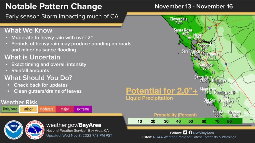
“By Monday, an unusually deep low pressure system will set up shop to the west of California and sit there for much of the following week–bringing multiple opportunities for (possibly significant) rain, wind, and mountain snow. This low pressure system will become “quasi-stationary” as it lingers offshore west of San Francisco for several days thanks to upstream blocking near the Aleutian Islands, allowing for the passage of both a primary and possibly multiple secondary cold/cool fronts over several days. At least one or two of these will be associated with (most likely) weak-to-moderate atmospheric rivers.”
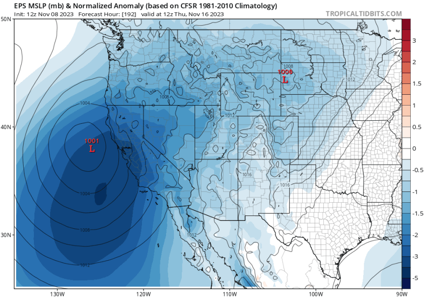
“In this case, though it’s not the atmospheric rivers themselves that will be responsible for the most significant weather: the favorable position of these low pressure systems will place California, at various points next week, under regions of divergent flow aloft thanks to multiple jet streaks moving overhead. That’s generally favorable for the development of surface low pressure and storm strengthening, which is fairly unusual for this early in the season. Additionally, there are some early indications that there may be at least a modest amount of atmospheric instability associated with next week’s systems (possibly enhanced by unusually warm near-shore ocean temperatures along nearly the entire CA coast at present) and possibly some subtropical moisture in the mix as well. That might help increase the likelihood of downpours and possibly some isolated thunderstorms despite the relatively modest atmospheric river conditions most likely to be associated with next week’s system(s).”

El Niño predictions

“I’ve [Dr. Daniel Swain] been closely following the ongoing development of El Niño since late spring, here on the blog and elsewhere, and so far long-lead predictions of where we’d be by November have actually been spot-on. A strong, and still strengthening east-based El Niño was predicted for November 2023–and that’s exactly what we’ve got right now. Nino 3.4 region ocean temperature anomalies have reached levels typically associated with “strong” events, and are expected to rise still further over the next 1-2 months. Right now, a large number of ensemble members from most of the world’s major modeling centers is suggesting that the present event will peak sometime between December and February at “super El Nino” levels (i.e., becoming a historically rare “very strong” event).“
Dr. Swain continues on with a fascinating in depth discussion of this year’s El Niño event here: https://weatherwest.com/
Stay tuned as meteorologists fine-tune next weeks forecast, and make sure to follow your favorite forecasters.