Convoys, Announced & Not

New sign at the bottom of Nacimiento at Highway One. Where’s the one for people coming over to the coast?

DSC_1212

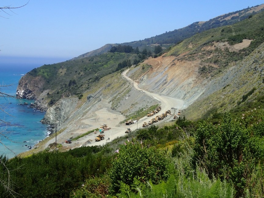
For the second time on a Wednesday between the scheduled, announced convoys we ran into another unannounced convoy. This was yesterday, 5/31, and  was 2 lead vehicles, 4 of the  super 10-yard trucks and 4 transfer trucks, which were super 10 yards pulling a loaded trailer. If a 10 yard exceeds the weight limit, then a transfer truck sure does. Hmm, here are the 4 trucks I saw pulling trailers of the 8 total. The little bridge I posted about is getting beat up. I will post the replies I have gotten, and next actions I will take.


From Senator Bill Monning’s Office;

“I spoke with Caltrans today and they informed me that the State investigated all structures prior to the first convoy several weeks ago and found it has the capacity to handle legal truck loads as defined by the vehicle code. As you are aware, the Department is not the owner of the road in question and therefore not responsible for the signage. However, we are responsible for the biannual inspections of the bridge and the load rating of the bridge. Monterey County has their own reasons for signing Nacimiento Creek Bridge under its rating.”

From MoCo Public Works:

“We have looked into this matter and the sign placed is an advisory signs for trucks. Our records indicate that the bridges along Nacimiento-Fergusson Road are capable of carrying loads legally allowed per the California Vehicle Code. However, the road is steep and narrow and thus the placement of the warning sign.”

Interesting that they say the above, and then post a brand-new sign.

I guess my next step is to try to get those biannual inspections from the County and for the state investigation.


Road Closure Update, 5/31/17

Mud Creek (PM 8.9) – MUD CREEK HAD A MAJOR SLIDE/SLIP OUT AT 9:30 PM, SATURDAY, MAY 20—IT LOST MILLIONS OF CUBIC YARDS OF MATERIAL AND REMAINS IMPASSABLE UNTIL FURTHER NOTICE.
·
Paul’s Slide (PM 21.6)— Paul’s Slide (PM 21.6)—ACCESS FOR LOCAL RESIDENTS AND DELIVERY VEHICLES ONLY THROUGH THIS FRIDAY, JUNE 2 ONLY.

AS WORK NEARS THE NARROWEST SECTION OF ROAD AT THIS LOCATION, WE ANTICIPATE INCREASED SLOPE INSTABILITY ABOVE THE ROAD AND AN INCREASE IN MOVEMENT OF SLIDE MATERIAL AND ROCK. CALTRANS NEEDS TO FULLY CLOSE THE ROAD DURING THIS PERIOD (SATURDAY, JUNE 3 THROUGH TUESDAY, JUNE 6) TO ENSURE PUBLIC SAFETY. WE ANTICIPATE RESUMING NORMAL HOURS OF LOCAL/DELIVERY ACCESS ON WEDNESDAY, JUNE 7. ANOTHER UPDATE WILL BE PROVIDED MID-DAY ON MONDAY, JUNE 5.

IMPORTANT NOTE: THE ROADWAY THROUGH PAUL’S SLIDE CAN CLOSE DOWN AT ANY TIME WITHOUT PRIOR NOTICE . CALTRANS NEEDS TO CONTINUE RE-ASSESSING THE SITUATION AND DETERMINE WHETHER LOCAL ACCESS CAN REMAIN THROUGH PAUL’S SLIDE.

· 12:00PM Monday / Wednesday / Friday– A single caravan south and a single caravan north, you must be in line by noon! There may be up to 45 minute delay to clear the road before the opening.

· Delivery vehicles (Restriction is 30 feet maximum length and 50,000 lbs. maximum weight) can now use all access windows 7 days a week.

· Access times for the morning and evening are still the same except for Friday:

5:30AM to 6:00AM and 7:00PM to 7:30PM – Sat.-Thurs.

· Friday’s hours will be shortened to:

5:30AM – 8:00AM and 6:00PM to 7:30PM

· The noon opening will be for PAUL’S SLIDE ONLY, (NOT MUD CREEK); you will need to use Nacimiento-Fergusson Road to exit the coast.

The targeted “public access” date of early July needs to be re-assessed with recent activity, public opening date could be pushed further

Paul’s Slide photos:

PM 21.6 Paul's Slide-1 5.30.17PM 21.6--Paul's Slide-2 5.30.17

Convoy on Thursday, 6/1/17

CALTRANS ANNOUNCES NEXT CONVOY TO PFEIFFER CANYON BRIDGE

MONTEREY COUNTY – Caltrans will continue the process of delivering construction equipment and materials to the site of the demolished Pfeiffer Canyon Bridge on State Route 1 via Nacimiento-Fergusson Road from US Highway 101 on Thursday, June 1.

These convoys will be escorted by the California Highway Patrol (CHP) and will include intermittent closures of Nacimiento-Fergusson Road on Thursday, June 1 from 8 am until 7 pm. Motorists wishing to travel east/west in the morning must do so before the first convoy begins. On Thursday, motorists will encounter delays during the movement of these four convoys westbound from 8 am to 10 am and 2 pm to 4 pm and eastbound from 11 am to 1 pm and from 5 pm to 7 pm. All vehicles must not exceed 30 feet in length and a weight of 15 tons.

The Thursday convoys will include the remaining 50% of the rock and sand necessary to create concrete abutments for the new bridge. Future convoys will transport two mobile batch plants, two concrete boom pump trucks, vacuum trucks and rebar cages. This equipment will be used to construct concrete abutments and overall construction of the new Pfeiffer Canyon Bridge (PM 45.52).

The steel girders for the new bridge continue being fabricated at a plant in Vallejo, CA. They have begun being moved to a plant near Stockton for painting before they are shipped to Pfeiffer Canyon. This $24 million project is expected to be open to the public in mid to late September.

A12 (1) (002)

Highway Closure Update, Monday 5/29/17

HIGHWAY 1 UPDATE – MONDAY, MAY 29 AT 5:30 PM:
PAUL’S SLIDE ON STATE ROUTE 1 CONTINUES TO BE FULLY CLOSED THROUGH TOMORROW MORNING, BUT WILL RESUME LOCAL/DELIVERY ACCESS AS OF TOMORROW, TUESDAY, MAY 30 EVENING. THE RADAR MONITORING SYSTEM CONTINUES TO BE IN PLACE. LOCAL ACCESS AND DELIVERIES AT THE PREVIOUSLY ANNOUNCED TIMES WILL RESUME TOMORROW EVENING, MAY 30. WE WILL CONTINUE RE-ASSESSING AND AND AN UPDATE PROVIDED BY MID-DAY THURSDAY, JUNE 1.

STATE ROUTE 1 REMAINS FULLY CLOSED IN BOTH DIRECTIONS AT MUD CREEK DUE TO CONTINUED SLIDE ACTIVITY. DELIVERY VEHICLES AND LOCAL RESIDENTS WILL NEED TO USE NACIMIENTO-FERGUSSON TO EXIT SOUTH OR TO CLEAR THE ACCESS TIMES AT PAUL’S

Mud Creek, Paul’s Slide & Technology photos, 5/29/17

These were taken Saturday and Sunday by various people, including Inga Dorosz, Richard Wangoe, Connie McCoy, and Rock Knocker.

MUD CREEK:

IMG_7356

Inga Dorosz

This slideshow requires JavaScript.

Rock Knocker

PAUL’S SLIDE

IMG_6219IMG_6220

Richard Wangoe

OLYMPUS DIGITAL CAMERAOLYMPUS DIGITAL CAMERAOLYMPUS DIGITAL CAMERA

Connie McCoy

This slideshow requires JavaScript.

Rock Knocker

TECHNOLOGY – GADGETS

IMG_7357IMG_7355

South Side of Mud Creek by Inga Dorosz

DSCN1887

South Side of Paul’s Slide by Rock Knocker

Designed for open pit mining, you can read about this technology here (thanks to Inga Dorosz for the link):

Slope Monitoring Radar

BTW, many local residents reported almost constant flying of Mud Creek yesterday. Inga spoke with one CT guy on the ground and was told they were using LIDAR in the air and sending the info back to the GPS by his car. The Slope Monitoring Radar information will be sent via satellite to Colorado where it will be monitored in real time, once work begins again.


Fire FHL, 5/27/17

Incident: 00241 Type: Report of Fire Location: 0 Del Venturi Rd Loc Desc: Lat/Lon: 35.999996 -121.254229.
Reported at 1:45 pm

Martha Karstens says E15 was called out to assist. No smoke visible for this one from my perch.

Fire??

I am making phone calls and sending emails. FHL FD says not them. Possibly northeast? Nothing on any of my usual sites. Clearly not near me, but it is near someone. No plume, which is good.

IMG_1564

Maybe left over from the Spreckels Fire last night?

IMG_2646

Photo from KSBW Dan Greene

Paul’s Slide blocked by rocks tonight, 5/26/17

This is in the very narrow one lane portion. No one will be there until Tuesday to work, due to dangerous conditions. One can see the soil nail wall covered in cement under the cone, so those of you who have driven it, know exactly where this is. Photo by Brendon Shave.

IMG_2644

IMG_2648

During daylight, photos by Brendon Shave

Here it is on the south side, photo by Cal Highway:

IMG_2647

The Slide that keeps on Giving – Mud Creek

On Tuesday, I sent this still from Brian Mack’s video taken on Sunday, marking up the fractures I saw on the north side of Mud Creek to several people, including Keith Vandevere. I meant to post it on my blog, but not sure I ever did. I did send it this am to Sterling Doughty and Brian Mack via PM on FB.

IMG_2551

So, this evening, Cal Highway posted these, tagging me.

IMG_2637IMG_2640IMG_2641IMG_2643

Look for those cones in the middle of the road up on the right to hit the beach by the end of the Memorial Day weekend, if not before. One can see the fractures and all the water in these photos. Thanks, Cal Highway.


Highway Closure Update, 5/25/17

From Cal Trans:

HIGHWAY 1 UPDATE – FRIDAY, MAY 26 AT 1 PM – PAUL’S SLIDE CONTINUES TO BE FULLY CLOSED TO EVERYONE

PAUL’S SLIDE ON STATE ROUTE 1 CONTINUES TO BE FULLY CLOSED TO EVERYONE AS OF 1 PM, THURSDAY, MAY 25. CALTRANS ENGINEERS REPORT CONTINUED SLIDE ACTIVITY AND THE AREA HAS BEEN CLOSED IN THE INTEREST OF PUBLIC SAFETY. THE RADAR MONITORING SYSTEM SHOWS SLIDE ACTIVITY HAS CONTINUED TO ACCELERATE; CALTRANS IS NOT COMFORTABLE WITH ANYONE ATTEMPTING TO PASS BELOW THE SLIDE AND MATERIAL REMAINS ON THE ROADWAY. LOCAL ACCESS AND DELIVERIES AT THE PREVIOUSLY ANNOUNCED TIMES HAVE BEEN SUSPENDED UNTIL AT LEAST NEXT TUESDAY, MAY 30, WHEN A RE-ASSESSMENT WILL TAKE PLACE AND AN UPDATE PROVIDED BY MID-DAY.

STATE ROUTE 1 REMAINS FULLY CLOSED IN BOTH DIRECTIONS AT MUD CREEK DUE TO CONTINUED SLIDE ACTIVITY. DELIVERY VEHICLES AND LOCAL RESIDENTS WILL NEED TO USE NACIMIENTO-FERGUSSON TO EXIT SOUTH OR TO CLEAR THE ACCESS TIMES AT PAUL’S SLIDE.

Aerial of Paul’s Slide:

PM 21.6 Paul's Slide Aerial 5.25.17

Aerial of Mud Creek:

PM 8.9 Mud Creek Aerial 5.25.17

Pfeiffer Bridge:

PM 45.52 PCB--Drilling of Abutment 1--5.25.17