CALTRANS USING GOATS TO CONTROL NON-NATIVE PLANTS ON HIGHWAY 1
SAN LUIS OBISPO COUNTY – Caltrans is using goats to aid in controlling weeds within a 20-acre site adjacent to Highway 1 just north of the Piedras Blancas Lighthouse. Instead of relying on herbicides, Caltrans is taking a more sustainable approach to revitalizing the native coastal prairie adjacent to the recent highway realignment project that was completed in 2017.
On Monday July 15th, two double decker trucks unloaded about 300 animals to help remove invasive non-native weeds such as bur clover, mustard, and thistle. The animals are confined to selected grazing areas by temporary fencing which is moved every few days. These goats will graze at a rate of approximately one acre per day, for the next three weeks. This project will also help to reduce the use of herbicides.
“I am proud that our Landscape Architecture group is committed to designing sustainable and innovative solutions through collaborative teamwork.” said Caltrans District 5 Landscape Architect, Katherine Brown, who is overseeing this project as part of an intensive habitat restoration project. The goats are managed by shepherds from Living Systems Land Management a subcontractor of the Caltrans prime contractor, Empire Landscaping Inc. of Davis, CA.
Caltrans reminds motorists to move over and slow down when driving through highway construction zones.
For traffic updates on other state highways on the Central Coast motorists can call Caltrans District 5 Public Affairs at (805) 549-3318 or visit the District 5 website
We are shifting hours to finish earlier in the day in effort to alleviate some of the afternoon backups, still on schedule to be complete by the end of summer.
Thanks for your patience this summer, Colin
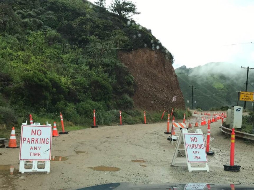
From: Ruiz, Heidi@DOT Sent: Friday, July 12, 2019 2:56 PM Subject: NEWS RELEASE (Monterey Co.) – CONSTRUCTION PROJECT ON STATE ROUTE 1 BETWEEN HURRICANE POINT AND ROCKY CREEK BRIDGE IN BIG SUR CONTINUES MONDAY, JULY 15
Today’s Date: Friday, July 12, 2019
District: 05 – Santa Barbara, San Luis Obispo, Monterey, San Benito and Santa Cruz Counties
CONSTRUCTION PROJECT ON STATE ROUTE 1 BETWEEN HURRICANE POINT AND ROCKY CREEK BRIDGE IN BIG SUR CONTINUES MONDAY, JULY 15
BIG SUR – A construction project to widen the shoulders on the existing roadway and upgrade the guardrail continues Monday, July 15 along State Route 1 between Hurricane Point and the Rocky Creek Bridge in Big Sur, Caltrans officials announced today.
This work will take place during the daytime hours and will require one-way reversing traffic control. The project location extends from 1 ½ miles north/south of the Bixby Bridge.
NOTE: Motorists can expect delays not to exceed 25 minutes. Expect heavier than normal traffic due to summer visitors. Electronic message signs have been posted alerting the traveling public of this project.
Roadwork will shift to the overnight hours when the paving and striping occurs. Details will be announced when certain.
HIGHWAY 1 PAVING BETWEEN CAYUCOS AND HARMONY CONTINUES NEXT WEEK WITH RAMP/LANE CLOSURES
SAN LUIS OBISPO COUNTY – A project to resurface the pavement and reconstruct the ramps and shoulders of Highway 1 from south of 13th Street in Cayucos to Harmony Valley Road will
continue next week with the following ramp closures:
Motorists will encounter a closure of the northbound Highway 1 on/off ramps at 13th Street and “C” Street Monday, July 15 through Thursday, July 18 from 8 am until 4 pm and during the overnight hours
from 6 pm until 7 am. These ramps will be closed Friday, July 19 from 6 am until 2 pm (13th Street) and from 7 am until 12 noon (C Street).
In addition, there will be lane closures in both directions of Hwy. 1 from 24th Street to Harmony Valley Road, Monday, July 15 through Thursday, July 18 from 8 am until 4 pm and
on Friday, July 19 from 6 am until 2 pm. Motorists can expect delays of 15 minutes.
Electronic message boards will inform the public about this roadwork. The California Highway Patrol (CHP) will ensure a safe environment for everyone.
The contractor for this $9.8 million project is CalPortland Construction of Santa Maria, CA. This project is expected to be complete this November.
Caltrans reminds motorists to move over and slow down when driving through highway construction zones.
For traffic updates on other state highways in San Luis Obispo County, travelers may contact Caltrans District 5 Public Affairs at 805-549-3318 or can visit the District 5 website at: http://www.dot.ca.gov/dist05/road_information.htm
I see no reason to publish the entire TAMC report each week, so here is the new information specific to Big Sur.
Highway 1: Hot Springs Creek Bridge – Burns Creek Bridge, Big Sur: July 9 One lane closure will occur on northbound and southbound Highway 1 between Hot Spring Creek Bridge and Burns Creek Bridge in Big Sur for a crack seal operation from 8 a.m. to 3 p.m.
Highway 1: Burns Creek Bridge – Anderson Canyon Bridge, Big Sur: July 11 One lane closure will occur on northbound and southbound Highway 1 between Burns Creek Bridge and Anderson Canyon Bridge for utility work from 7 a.m. to 3:30 p.m.
Highway 1: Ventana Entrance – Nepenthe North Entrance, Big Sur: July 9 One lane closure will occur on northbound and southbound Highway 1 between the entrance to Ventana and the north entrance of Nepenthe for a crack seal operation from 8:15 a.m. to 1:30 p.m.
Highway 1: Pfeiffer Canyon Bridge – Ventana Entrance, Big Sur: July 10, July 12 One lane closure will occur on northbound and southbound Highway 1 between Pfeiffer Canyon Bridge and Ventana entrance for survey work from 8 a.m. to 3:30 p.m.
PARKING AND TRAFFIC CONTROL ON STATE ROUTE 1 FOR ESALEN MIDSUMMER FESTIVAL
MONTEREY COUNTY – The Esalen Midsummer Festival will begin Monday, July 1 through Sunday, July 7. (UPDATE: FESTIVAL ONLY JULY 6TH, NOT ALL WEEK) An approximate one-mile section of Hwy. 1 in the vicinity of Esalen will be under traffic control during this period, Caltrans officials announced today.
Parking will be provided along the dirt shoulder with specific parking locations. Motorists can expect minimal delays. Caltrans would like to remind motorists to share the road.
NOTE: Electronic message boards alerting motorists will be activated to alert motorists of this event.
Caltrans reminds motorists to move over and slow down when driving through highway work zones.
Caltrans will be holding a public meeting next Wednesday evening to get input on their Sustainable Transportation Demand Management Planning for the Big Sur coast.
Sustainable Transportation Demand Management (TDM) Strategies that encourage a shift from single occupant vehicle (SOV) trips to transit, biking, walking, or other forms of transportation; or shift trips out of peak periods. TDM seeks to reduce auto trips – and hopefully vehicle miles traveled – by offering a variety of transportation option tools and management strategies.
CALTRANS TO BUILD VIADUCT AND RETAINING WALL ON HIGHWAY 1 NEAR RAGGED POINT
SAN LUIS OBISPO COUNTY – Caltrans will begin preliminary geotechnical work on a project to construct a viaduct and retaining wall on Highway 1 near Ragged Point on Monday, June 10.
This emergency project located between the San Carpoforo Creek Bridge and the Ragged Point Inn. (For those who know, it is at the Polar Star) It will result in intermittent lane closures through July 2019.
A temporary traffic signal will be activated by August allowing traffic to move in each direction 24/7until project completion.
Roadwork will take place Monday through Thursday from 6 am until 6 pm and from 6 am until 2 pmon Fridays. Electronic message boards will alert travelers about this roadwork.
The contractor for this $4.1 million project is Souza Engineering of San Luis Obispo, CA. It’s scheduled to be complete by Spring of 2020.
Caltrans reminds motorists to move over and slow down when driving through highway construction zones.
In preparation for the 119th U.S. Open Championship, the United States Golf Association (USGA) and Pebble Beach company unveiled a comprehensive transportation plan to ensure the safe and efficient movement of traffic and pedestrians during the championship, scheduled for June 10-16.
More than 16,000 satellite parking spaces have been secured to help ensure that the anticipated 250,000 fans at the U.S. Open experience trouble-free travel to and from the Pebble Beach. Local traffic representatives from the California Highway Patrol, Monterey County Sheriff’s Office, and California Department of Transportation (Caltrans) have been involved in the 18-month-long planning process with the USGA and Pebble Beach Company.
All fans traveling by car during U.S. Open week should follow event trailblazing signage to California State University Monterey Bay (CSUMB) in Marina, CA, where complimentary parking and shuttle transportation will be provided to and from Pebble Beach. Shuttles will run continuously beginning at 5:30 a.m. PDT each day and continue for one hour following the conclusion of play. One-way shuttle times are expected to take approximately 30-35 minutes, depending upon traffic.
There is no general parking for fans with disabilities available in the immediate vicinity of Pebble Beach Golf Links. All other parking is by permit only. Parking restrictions surrounding the championship grounds and within the Del Monte Forest will be closely monitored and enforced. 17-Mile Drive will be closed to tourist traffic June 9 through June 16, 2019.
Handicapped-accessible parking spaces will be available at all championship parking areas for vehicles displaying appropriate HP/DP license plates or placards. Individuals requiring lift-equipped transportation are encouraged to contact the USGA Admissions Office at 800-698-0661 for more information.
The cities of Carmel, Monterey and Pacific Grove are offering express shuttle bus services to the U.S. Open for residents and community guests. For more information on fees, daily schedules, frequency, and locations of service, please visit the Carmel Chamber of Commerce (carmelchamber.org), Cannery Row Company (canneryrow.com) and Pacific Grove Chamber of Commerce (pacificgrove.com) websites.
Fans and local residents wishing to utilize ride-share options to be dropped off at the championship should utilize the designated Passenger Drop-Off area along Forest Lake Road, located near Gate 1 within the Del Monte Forest. There is no parking or staging for vehicles, so pickup times will need to be coordinated accordingly. Vehicles proceeding to the Passenger Drop-Off are instructed to enter the Del Monte Forest through the Pacific Grove Gate or Morse Gate located on CA-68. Please follow directional signs and attendants to the appropriate pickup and drop-off location. Due to traffic restrictions, access is limited to vehicles no larger than a 12-passenger van or limousine. Passenger Drop-Off vehicles are not permitted to pick-up or drop-off at any other location around the championship grounds.
For the week of Monday, June 10 through June 16, local residents and through traffic are encouraged to adjust travel around peak U.S. Open arrival and departure times (7-11 a.m. and 3:30-7:30 p.m.) if possible. The local residents and area commuters from Castroville Blvd. to eastbound Hwy. 156, there will be no left turn out of Castroville Blvd. onto eastbound Hwy. 156 from Wednesday, June 12 at 10 am through Monday, June 17 at 10 am. There will be a detour to turn right from Castroville Blvd. onto westbound Hwy. 156 traffic will exit at SR-183/Merritt Street then a left at Merritt Street and a left turn back onto eastbound Hwy 156.
Local residents and area commuters from the Salinas Valley are encouraged to follow alternate routing and trailblazing signage to General Jim Moore Boulevard, avoiding CSUMB and CA-1. Due to U.S. Open traffic, delays can be expected along the primary routes of CA-1 from Exit 399A (Pebble Beach) to Exit 414 (Nashua/Molera Road). Monterey and Pacific Grove commuters should avoid the use of Exit 399A and CA-68 during peak times.
AIDS/LIFE CYCLE BICYCLE RIDE ON CENTRAL COAST NEXT WEEK
CENTRAL COAST – The AIDS/Life Cycle Bicycle Ride will move through Santa Cruz, Monterey, San Luis Obispo and Santa Barbara Counties next week. The cyclists will use the state highway system during the daytime hours between 6:30 am and 7 pm in the following locations:
Sunday, June 2, the riders will use southbound State Route 1 and US 101 before arriving at Harvey West Park in Santa Cruz County during the afternoon hours.
On Monday, June 3, the riders will leave Santa Cruz and use portions of southbound State Route 1 and US Highway 101 ending their day at San Lorenzo County Park in King City in Monterey County.
On Tuesday, June 4, the riders will leave King City and use a portion of southbound US Highway 101 before reaching the Paso Robles Fairgrounds in San Luis Obispo County.
On Wednesday, June 5, the cyclists will leave Paso Robles using Hwy. 46 West to Hwy. 1 south through Morro Bay and Pismo Beach before reaching Preisker Park in Santa Maria in Santa Barbara County.
On Thursday, June 6, the cyclists will leave Santa Maria towards State Route 1 and continue south ending their day at Ryon Memorial Park in Lompoc in Santa Barbara County.
On Friday, June 7, the riders will leave Lompoc and use State Route 246, State Route 1 and US Highway 101 towards southern Santa Barbara County before ending their day at San Buenaventura State Beach in Ventura County.
The California Highway Patrol (CHP) will be present to maintain a safe environment for motorists, cyclists and support vehicles. The riders will travel single file with the flow of traffic.
Caltrans reminds motorists to move over and slow down when driving through highway construction zones.
For traffic updates on other state highways on the Central Coast motorists can call Caltrans District 5 Public Affairs at (805) 549-3318 or visit the District 5 website
Most of you have heard, by now, of the fiasco that was Bixby Bridge this weekend. This was Saturday, by Adam Slawter. At 6:30 pm, it was backed up from Bixby to Palo by cars going south. That is 2.2 miles of idling vehicles.
This is the video taken by Tim Huntington on Saturday at 2 pm of the cars headed south, as he was heading north: https://vimeo.com/338490145
This was what it looked like early – as in 9 am – on Sunday, in the rain. Martha Diehl took these photos. Note the door opening into traffic immediately before another vehicle in the last photo.
Imagine that there is an emergency, which is much more likely with the influx of clueless people from out of the area. What happens then? How do emergency vehicles navigate through this quagmire? They can’t. How are the Cal Fire engines and others supposed to get to us when there is a fire this summer? Or cliff rescue, or serious injuries? This is a life-threatening situation that must be resolved.
Monday, a temporary solution presented itself. MCSO stationed THREE officers here at Bixby and they managed to keep traffic moving, at least until early afternoon, one source told me. So we need to pressure the County to assign 3 officers every weekend and holiday to manage the traffic at this bottleneck.
On the brighter side, CABS was there educating and interacting with the tourists on Monday morning, raising the awareness of our visitors to treat Big Sur with respect.
(Photo by Patte Kronlund)
(Photo by Lisa Kleissner)
Let us start preppering our Supes to take action, now! We don’t need to come up with a “perfect” solution, I don’t have one. But we could try a variety of things to see what will work, short of painting the bridge puke green. We could experiment with running shuttles, or the current MST buses, allowing only them to park, or to drop off and pick up visitors to the bridge from a staged area north and south. The County of Monterey could pass an ordinance, for health & safety reasons, prohibiting parking on both eastern and western sides and OCR, assess BIG fines, and enforce it! If you have another idea, I am all ears. Toss those ideas out there, no matter how crazy they seem. It might just give someone else the inspiration they need to find a solution that will work.