Evacuation Order for Tassajara RD from Chew’s Ridge to Zen Center

U. S. Forest Service – Los Padres National Forest

SOBERANES FIRE: EVACUATION ORDER
9:00 PM
September 10, 2016

An evacuation ORDER for Tassajara Road from Chews Ridge south to the end of the road at Tassajara Hot Springs has been issued by the Monterey County Sheriff Department effective 9 p.m. on Saturday, September 10, 2016.

The previous evacuation WARNING continues for the Tassajara Road from Chews Ridge north to Carmel Valley Road and roads that leave from that section of Tassajara Road.

All residents covered by this evacuation Order need to leave the area. Be sure to take any medications, pets, important documents, and family valuables. Close all windows and doors before leaving.

Evacuation Warning Expanded on East Side of Soberanes Fire

SOBERANES FIRE: EVACUATION WARNING EXPANDED

RELEASE DATE: September 10, 2016 TIME: 18 00
SOBERANES FIRE: EVACUATION WARNING EXPANDED

An evacuation WARNING along the east side of the Soberanes Fire has been expanded to include an area along Arroyo Seco effective 6 p.m. on Saturday, September 10, 2016.

The new evacuation Warning applies to all residents southwest of East Carmel Valley Road starting at the intersection of East Carmel Valley Road and Piney Creek Road extending East to Arroyo Seco Road. It also applies to all residents along Arroyo Seco Road starting from East Carmel Valley Road extending west past the Arroyo Seco Campground.

An evacuation Warning is a precautionary notice that an evacuation Order may become necessary if the threat increases. The new Warning is due to the potential for the fire to spread toward these areas.

All residents under a Warning should prepare to leave the area. Be sure to take any medications, pets, important documents, and family valuables if asked to leave. Close all windows and doors before leaving.

(NOTE From BSK: I saw some impressive plume photos taken from the Zen Center earlier today that show new wildfire activity that appear to be somewhere in the Willow Creek drainage, per Steve Harper – the one on the east side of LPNF, not the Willow Creek down on the South Coast.)

Found Dog – OWNER FOUND

I LOVE A HAPPY ENDING!! Owner found while dog still at vet’s. Thank  you Alyca and all who helped spread the word.

From Alyca Tanner:

Found this handsome boy wandering through Monterey and the phone number on his tag doesn’t work. Owner’s name is Craig Underwood, but the tag says he lives inCachauga. I’m taking him to work with me at Nichols Veterinary Care to see if he has a tag. I live in a small apartment and cannot keep him.

image

I know Labs often look a little sad, but this one looks particularly so. Let’s reunite him and his owner.

Soberanes Fire, Day 51, 9/10/16

4:30 pm – look at the fascinating map of all the water sources along the western containment line I found on Google Earth. I remember these “pumpkins” from prior fires being called “bladders.” I like pumpkins better.

image

2:30 pm – From today’s firing operation around noon between Anderson Peak and Marble Peak, Photos by Cordelia Cluett:

This slideshow requires JavaScript.

2:30 pm – John Chesnut sent this to me this am, but life happened, and I am just now getting around to posting it.

image

6 am – We lost another 605 acres of forest for a total of 103,847. Here are today’s maps:

image

IR Topo Map in PDF

image

South Ops Map in PDF

And here are the fire prediction and weather forecast discussions:

imageimage

Soberanes Fire, Day 50, 9/9/16

5:30 pm – Sorry, I was not around today. I had to go to Templeton, Paso Robles, and Cambria. I do intend to be home all weekend, however, so will be keeping an eye on things. From late this afternoon (about 1/2 hour ago) the incident report has this to say:

“Despite cooler temperatures and marine moisture in the morning at low elevations, open fireline became active by late morning with upslope runs carrying to ridgelines above. Aircraft was used to check fire spread in several areas.
Most activity was terrain driven through the burn period.
The most active burning was on the southern end of the fire. Fire continues to spread actively both down drainage toward Lost Creek and upslope on the slopes and ridges above it, both east and west. There was some active burning in areas at the bottom of Pick Creek beneath the area burned out yesterday.
There was also aggressive burning in unburned interior areas such as Cienega Creek and the North Fork of the Big Sur River. Managers continued to increase resource capacity on the east side of the fire in response to fire spread. Structure protection planning in that area was finalized. Managers also continued to scout opportunities for evaluation points and geographic locations that have successfully held previous fires.
The uncontained fire edge in Willow Creek did not show signs of significant growth today. Managers continued collecting data on previously used indirect lines on the southeast side of the fire. Previous fire control action points were scouted to be utilized as contingency lines.
Structure protection actions continued on Partington Ridge and south from Julia Pfeiffer Burns State Park to Dolan Road.”

7:30 am – John Chesnut’s Map:

image

5 am – here are the day’s maps:

image

IR Topo Map in PDF

image

South Ops Map in PDF

And the Fire Behavior and Weather Predictions:

imageimage


Best Buddies Ride Saturday

Today’s Date: Thursday, September 8, 2016
District: 05–Santa Barbara, San Luis Obispo, Monterey, San Benito and Santa
Cruz Counties
Contact: Jim Shivers or Colin Jones
Phone: (805) 549-3237 or (805) 549-3189
FOR IMMEDIATE RELEASE

11th ANNUAL BEST BUDDIES CHALLENGE BICYCLE RIDE COMES TO THE CENTRAL COAST THIS SATURDAY

CENTRAL COAST – The 13th Annual Best Buddies Challenge bicycle ride will take place on Highway 1 on Saturday, Sept. 10. The ride will begin at the
Quail Lodge on Carmel Valley Road in Monterey County and continue south on Hwy. 1 ending in San Simeon.

Traffic control for this ride will begin at 7 am and consists of rolling closures by the California Highway Patrol (CHP).

There will be three additional starts at the Big Sur Station at 8:30 am, at Sand Dollar State Park at 10 am and at Ragged Point at 11 am.

In addition, Electronic Message Boards will be posted alerting motorists to ‘Share the Road’ with cyclists. Motorists can expect delays not to exceed 15 minutes.
All riders will be off the road by 4 pm.

Caltrans reminds motorists to be aware of these cyclists and any support vehicles. For more information regarding this event, please visit the Best Buddies Challenge website at: https://www.bestbuddieschallenge.org/hc/event-guide/

(Yes, it says both that this is the 11th Annual and the 13th Annual. I don’t know which, but the ride will take place regardless.)

Soberanes Fire, Day 49, 9/8/16

7 pm – This is the afternoon MODIS from 1:20 pm today, by John Chesnut. This shows a couple of troublesome spots, one of which could impact Tassajara, if the winds align. Let’s hope they don’t.

image

image

8:30 am – One of the things I like about John Chesnut’s maps, is it is easy to see the topography of the land the fire is approaching and tell where the ridges and drainages are, which makes it a bit easier to see where the fire MIGHT go from here.

image

7:00 am – there is a very moving article about the fire by author Patrice Veecchione in yesterday’s Herald. You can read it here:

What the fires have left behind

6 am – today’s maps: (having trouble with uploading the maps again-but at least I can post the links here). Today’s Topo reveals the current acreage to be 102,499 or an increase of just over 1000 acres since yesterday. One map reveals that the distance between the now-contained Chimney Fire and the still raging Soberanes Fire has dropped another mile to 33 miles.

image

IR Topo in PDF

image

South Ops Map in PDF

imageimage

Jade Festival 2016 Permit denied due to Soberanes Fire

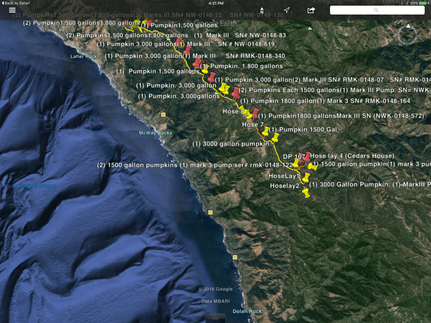
I will keep all informed as to the decision of the Jade Festival Committee, which is meeting on the 8th. It has been suggested that the Festival be postponed until Spring. I don’t know what they will decide, but will let everyone know when I do. I know this is a disappoitment to many, but given the circumstances, I concur with the USFS decision in this matter. Generally, campers are all up and down Plaskett, Willow, and Nacimiento, which cannot be allowed this year. While the Soberanes is predicted to be contained by 9/30, I think we all know better. It has remained at 60% containment for over 3 weeks now, and is steadily moving south, closer and closer to the South Coast of Big Sur.

From Monterey District Ranger Tim Short addressed to me, the SCCLT, and Gordon Pfiffero, the Superintendent of Pacific Valley School:

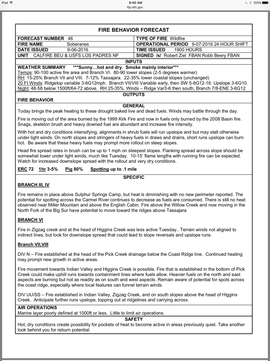
“1. The active Sobranes Fire continues to expand in a southerly direction within the big box containment line. Although current containment projections are for September 30, this incident could burn well past this date depending on conditions. In either case it will continue to require full commitment of local USFS resources.
2. A district wide closure order was implemented to help reduce the risk of another human caused fire start given our extreme fire conditions that is a result of multi-year drought, low fuel moistures, significant fuel loading etc. We must continue to do what we can to avoid another human caused fire in addition to the current incident.
3. Given the existing district closure and assuming existing conditions continue into October, there will be no camping available for the public outside of the existing concessionaire operated developed campgrounds.
4. Managing the Jade festival does require a level of agency cooperator support such as law enforcement and fire patrols. Given the current emergency fire situation for which USFS and cooperator resources are stretched, this effort would further strain that limited capacity.

The USFS annually supports this important event and assists through the permitting process. However, at this time, based on current conditions and due to reasons described above, we unfortunately cannot issue a permit. Thanks for everyone’s cooperation and understanding through this challenging period. We all are looking forward to a return to some level of post fire normalcy.”

Soberanes Fire, Day 48, 9/7/2016

5 pm – here is a photo of the firing operation behind Anderson Peak by Cordelia Cluett:

image

Great photo, Cordelia. Thank  you for sending it.

Noon – from a resident of Partington Ridge: “I spoke with one of the firefighters this morning and they are headed back to Partington today because they are going to try and back fire a small area behind Partington that didn’t burn before…”

10:30 am – still  having trouble uploading maps, but did at least get the link for South Ops up, and finally showing enough of the south that I am in there. Here is the daily report:

The fire is still 2 1/2 miles south and west of Tassajara. Fire retardant is being used from the air to help manage the fire. Smoke plumes are visible from Tassajara, but the air quality in the Valley is good.
Total acres: 101,490
Acreage increase: 511
Containment: 60%
Total Personnel: 1,196
Temperatures are expected to be hotter today, with highs in the Interior of the fire expected in the 100-degree range. High pressure is moving inland, bringing moderated southwest winds over the fire area. The southerly winds could produce visible smokes for residents on the north end of the fire.
Fire is burning actively to the east along Zigzag Creek (picture below) and above the Willow Creek drainage. Fire is mainly moving through the heavier brush and dead fuels from the Basin Fire of 2008. Easterly fire growth on the ridge between Zigzag and Willow creeks is expected. This is creating short-lived columns of smoke visible from Tassajara and Highway 1.
There is some fire activity around Black Cone Mountain and the Willow Creek headwaters. Some fire activity south of the North Fork of the Big Sur River continues to spread as slope and fuels line up. Managers continue to monitor fire spread, hold and improve control lines and assess proximity and thread to indirect control lines.

6:30 am – this morning’s maps are being difficult and do not want to upload. Will be uploaded when cooperation is achieved.

image

IR Map in PDF


South Ops Map in PDF

If possible, I will load the weather and fire behavior discussions from the IAP:

image

image