
To all you fathers out there, have a great one!


To all you fathers out there, have a great one!
BTW, the subtitles are not the actual conversation, it was added for fun and also to make the point re putting a fire out so it is cold to the touch.
4:30 pm — Forward Progress stopped at 6-7 acres.
Carmel Fire 06/13/2022 1530 hours, Photo credit Laurel Nason

3:11 pm — fire is 1/2 mile north of White Oak Campground per scanner traffic. and from WatchDuty: ”The fire is located approx a 1/2 mile north of the campground. The fire is now 3 acres & appears to be holding w/ good progress being made by aircraft per radio traffic. 2 additional handcrews requested.”
I highly recommend getting the WatchDuty app available for both O/S and Android. I am on the WD team.
2:50 pm — fire at Chew’s Ridge per CHP:
| Detail Information | ||
| 2:45 PM | 7 | [12] ****** PER CALFIRE / FIRE AT CHEWS RIDGE ***** |
| 2:43 PM | 6 | [9] [Appended, 14:44:54] [4] RP CALLING F/ CARMEL VALLEY VILLIAGE/COUNTRY CLUB HTS // FIRE NEG IN THIS AREA |
| 2:42 PM | 5 | [8] [Appended, 14:44:54] [3] SEES SMOKE ONLY |
| 2:42 PM | 4 | [7] [Appended, 14:44:54] [2] EAST IN HILL // POSS ON TASSARJA RD |
| 2:28 PM | 3 | [4] SMOKE VISIBLE |
| 2:27 PM | 2 | [1] ACROSS FM PSOS SMOKE AT TASSARAJA |
| 2:01 PM | 1 | [17] [Appended, 14:45:48] [5] FIRE NOT ON FREMONT PEAK // RP SEES FIRE |
2:30 – While in training as a reporter for the new app WatchDuty, I got the notification re the Carmel Fire at or near White Oaks Campground on Tassajara. I am still gathering information, so will flesh this out in 15 or so. 2 acres, Slow Rate of Spread. (SROS)


5:30 PM FORWARD PROGRESS HAS BEEN STOPPED. Ground crews have a handle on it.
5: 00 Vegetation fire threatening structures. One report is it is 100 yards wide. Still gathering info.

I have to take a short break, as this is the time I take care of my dogs. Back in a bit.


Forward progress stopped at 10 acres per air attack.

| Detail Information | ||
| 1:25 PM | 17 | [64] [Appended, 13:27:15] [1] SEES FIRE |
| 1:24 PM | 16 | [60] [Appended, 13:24:51] [2] TRANS MTRY COM |
| 1:24 PM | 15 | [59] [Appended, 13:24:51] [1] RP SEES SMOKE COMING FROM RYAN RANCH AREA |
| 1:22 PM | 14 | [58] A27-068 JUST REQ TO MOVE PRTYS BECAUSE FIRE IS MOVING EAST , CIVILIANS AT THE TOP ,FIRE HAS REQ SUBJS BE REMOVED |
| 1:19 PM | 13 | [56] PER DEPUTY FIRE IS POSS MOVING TWDS THE CAMP GROUND TWDS THE EAST , 5 ACRES NOW |
| 12:52 PM | 12 | [50] [Appended, 12:54:03] [3] SEES SMOKE FROM A DISTANCE |
| 12:52 PM | 11 | [48] [Appended, 12:54:03] [1] FIRE NR DRIVING RANGE |
| 12:51 PM | 10 | [45] [Appended, 12:52:07] [2] RP SEES LOTS OF WHITE SMOKE |
| 12:48 PM | 9 | [36] TRANS MTRY COM |
| 12:47 PM | 8 | [34] TRANS MTRY COM |
| 12:46 PM | 7 | [30] [Appended, 12:46:48] [2] TRANS MTRY COM |
| 12:46 PM | 6 | [29] [Appended, 12:46:48] [1] SMOKE SEEN IN AREA OF SR68 |
| 12:45 PM | 5 | [28] TRANS MTRY COM |
| 12:44 PM | 4 | [20] [Notification] [CHP]-PER ADD CALLER AT LAGUNA SECA RANGE / TRANS MTRY COM [Shared] |
| 12:41 PM | 3 | [11] [Appended, 12:42:50] [1] BRUSH FIRE |
| 12:39 PM | 2 | [9] CLOSER TO RD GOING UP TWRDS SPEEDWAY AND GOING DOWN TWRDS ENTRANCE // NEG CLOSER TO FWY |
| 12:38 PM | 1 | [4] LARGE FIRE |
The majority of the workshop will be held outdoors and MASKS WILL RE REQUIRED for attendance due to the uptick in Covid cases in Monterey County.
Los Padres officials to hold public workshop on coastal zone visitor use management strategy
All interested parties are invited to attend the public open house workshop from 10 AM to 3 PM on Wednesday, June 8 at the Big Sur Lodge in Big Sur (directions). Please park at the main lot in front of the Lodge and walk up the hill to the Conference Center. The workshop will be open to all members of the public who are interested in sharing ideas, concerns, and potential management actions.
The Monterey Ranger District Of the Los Padres National Forest will host a public workshop focused on developing a visitor use management (VUM) strategy to address visitor use of Big Sur/South Coast areas that are managed by the Forest Service. The lands under study start at the Brazil Ranch and extend south to San Carpoforo Creek. The eastern boundary is generally the coast ridge.
Note: There will be ample opportunity to provide written input if you are unable to attend the June 8 event, see the website below for further information and to submit written comments or use the email address below.
USFS Story Maps website:
Coastal Zone Visitor Use Management StoryMap
(see “Get Involved” tab for collaborative map options)
or by e-mail to SM.FS.BigSurVisUse@usda.gov.
The visitor use management project is focused on National Forest system lands that are accessed from Highway One.
The VUM will follow the process described by the Interagency Visitor Use Management Council with the goal of providing sustainable recreation opportunities and access by identifying desired conditions, adaptive management strategies, and management tools.
Questions may be directed to Monterey Ranger District Resource Officer Fin Eifert by e-mail to john.eifert@usda.gov or by calling (831) 385-5434.
7:30 pm — forward progress stopped, 100 ac and 25% contained, per Watch Duty (an app you all need to have on your phone)
6:40 pm — The fire has spotted outside the lines, is 30-40 acres, has a moderate rate of spread. Sending 2 additional tankers, 2 additional dozers and 2 additional crews.
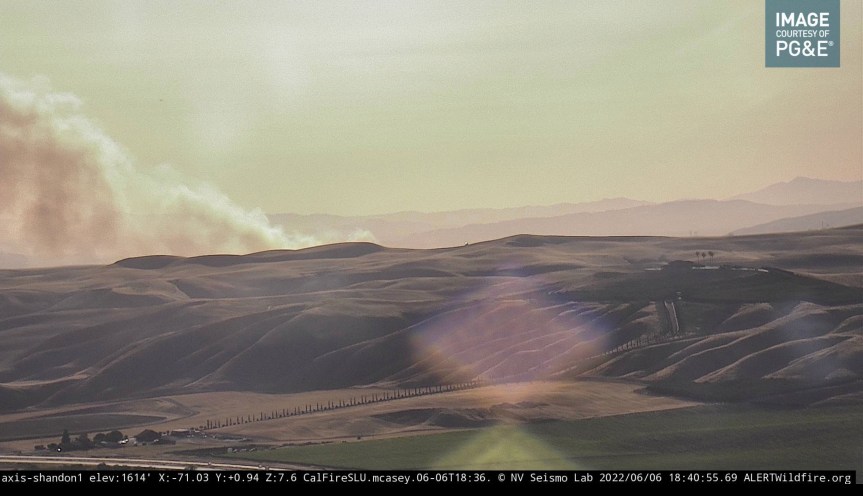
From Cal Fire on their twitter account: ”WILDLAND FIRE: #EagleIC and firefighters responding to a Wildand Fire East of Paso Robles.#CountyofSlo #PasoRobles” at 6:10 pm T75, T78 overhead from Paso Robles.. Ground resources are making access.

Here are a few I took on my way home yesterday. None of these are legal campsites. This was a quiet weekend. Sunday of Memorial Day weekend saw 700 trips up and down this mountain, which means a minimum of 350 vehicles. Please watch the CBS video I posted at the end. It is where Big Sur must head.


And here is a special from CBS that aired 1 week ago. This is what will have to happen here, in Big Sur.