Prescribed burn – FHL tomorrow, 6/2

The FHL Fire Department with other cooperating agencies are planning to conduct a 1K acre control burn on June 2 at Training Area 24; Long Valley (Sam Jones Road and FOB Ward), 0900 – 1800 hours. WEATHER PERMITTING ONLY.

Rat Creek Boring Action

Lots of photos. These were taken last Friday and Saturday by Cal Trans and Dave Nelson,

Photo by Dave Nelson
Caltrans photo
Caltrans Photo
Caltrans photo
Caltrans Photo
Caltrans photo

Tomorrow, I will post the aerial photos.

Memorial Day, 2021

We remember the fallen…

And after remembering our fallen, take a look at a life photo essay of Memorial Day traffic jams in 1949 to put today’s traffic jams in perspective: https://www.life.com/lifestyle/memorial-day-traffic-1949/

Wildfires near Pozo and/or No of Lake San Antonio

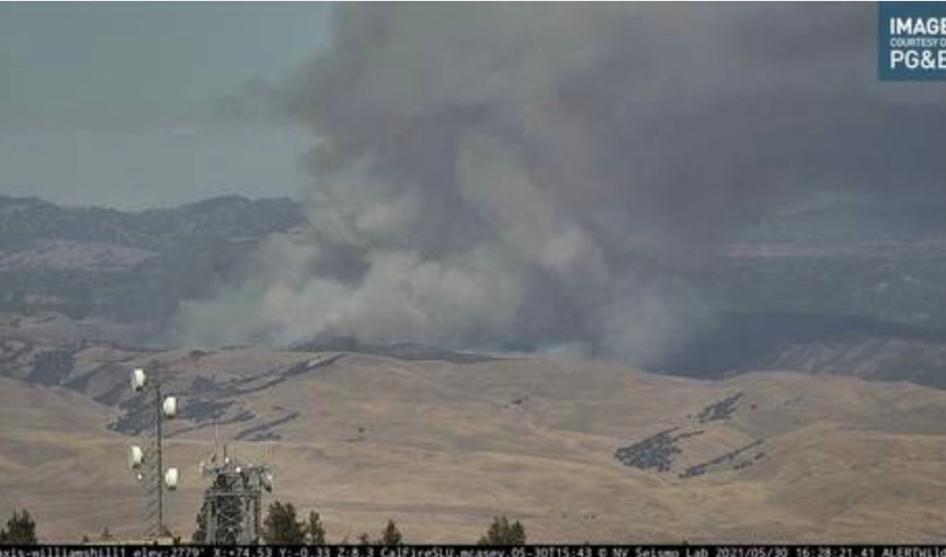
8:30 pm UPDATE: 800 acres, forward motion stopped. 50% contained and doing a firing operation tonight.

6:30 pm UPDATE: 500 Acres with a potential for 2000 this burn period. Orders for tomorrow: Day shift resources order of 6 Charlie strike teams, 4 dozers( probably the same ones from today with new operators) 2 strike teams of crews, 4 divisions

4:30 pm — Aircraft are flying it now. One report is 50 acres.

05/30/2021 13:19LPF-1234BEEWildfireQUEEN BEE SL.CRW1LPF DIV1LPF E315LPF4X4 E335LPF E338LPF4X4 PAT18LPF Q WT23LPFSUPT 1 Effective 5/30/2021 1438.1.535 17.196, -120 27.10230S R14E Sec 23.

There is another one called Sergeants north of Lake San Antonio, also a BEU fire:

05/30/2021 13:41LPF-1235NewWildfireacross from Mkneil truck tail.....35 17.376, -120 26.46030S R14E Sec 23.

There two fires may be merging. Here is probably the location:

Forest Closure Order Modified for MRD of the LPNF

Sorry I am late with this, but today I need to stock up on groceries for the weekend.

FOREST ORDER NO. 05-07-51-21-05
LOS PADRES NATIONAL FOREST
MONTEREY RANGER DISTRICT
DOLAN FIRE EMERGENCY ROAD, TRAIL, AND CAMPGROUND CLOSURE
Pursuant to 16 U.S.C. § 551 and 36 C.F.R. § 261.50(a) and (b), and to provide for public safety, the following acts are prohibited in the Monterey Ranger District within the Los Padres National Forest. This Order is effective from May 29, 2021, through July 28, 2021.

  1. Being on the following National Forest System Roads, as shown on the attached map:
    a. Forest Road 22S01 (Nacimiento-Fergusson Road) from its intersection with State Highway 1 in Section 26, Township 22 South, Range 4 East, Mount Diablo Base and Meridian (MDBM) for approximately 10.3 miles to the western entrance of Nacimiento Campground in the SE 1⁄4 of Section 15, Township 22 South, Range 5 East.
    b. Forest Road 20S05.4 (South Coast Ridge Road) from its intersection with Forest Road 22S01 (Nacimiento-Fergusson Road) in the NW 1⁄4 of Section 20, Township 22 South, Range 5 East for approximately 4.1 miles to its intersection with Forest Road 22S04 (Prewitt Ridge Road) in the SE 1⁄4 of Section 32, Township 22 South, Range 5 East.
    36 C.F.R. § 261.54(e).
  2. Operating a motor vehicle on the following National Forest System Roads, as shown on the attached map:
    a. Forest Road 20S05.3 (Central Coast Ridge Road / Cone Peak Road from its intersection with Forest Trail 3E10 (North Coast Ridge Trail) in the NW 1⁄4 of Section 1, Township 22 South, Range 4 East for approximately 6.4 miles to its intersection with Forest Road 22S01 (Nacimiento-Fergusson Road) in the NW 1⁄4 of Section 20, Township 22 South, Range 5 East, as shown on the attached map.
    b. Forest Road 19S09.3 (Arroyo Seco – Indians Road) from the gate in the SW 1⁄4 of Section 7, Township 21 South, Range 5 East near Memorial Park Campground for approximately 2.8 miles to the gate in the NW 1⁄4 of Section 1. Township 21 South, Range 4 East near Escondido Campground.
    c. Forest Road 19S09D (Escondido Campground Road) from its intersection with Forest Road 19S09.3 (Arroyo Seco – Indians Road) in the NW 1⁄4 of Section 1, Township 21 South, Range 4 East for approximately 0.2 mile to its ending terminus in the NE 1⁄4 of Section 2, Township 21 South, Range 4 East.
    36 C.F.R. § 261.54(a).
  3. Being on Forest Trail 4E17 (Kirk Creek Trail) from its intersection with State Highway 1 in Section 26, Township 22 South, Range 4 East for approximately 5.0 miles to its intersection with Forest Trail 4E13 (Stone Ridge Trail / Vicente Flat Trail) in the SW 1⁄4

of Section 12, Township 22 South, Range 4 East, as shown on the attached map. 36 C.F.R. § 261.55(a).

  1. Entering or using the following campgrounds:
    a. Chalk Peak Campground in the NW 1⁄4 of Section 33, Township 22 South, Range 5 East, as shown on the attached map.
    b. Escondido Campground in the NE 1⁄4 of Section 2, Township 21 South, Range 4 East, as shown on the attached map.
    36 CFR 261.58(b).
    Pursuant to 36 C.F.R. § 261.50(e), the following persons are exempt from this Order:
  2. Any Federal, State or Local Officer or member of an organized rescue or fire fighting force in the performance of an official duty.
  3. Persons with Forest Service Permit No. FS-7700-48 (Permit for Use of Roads, Trails, or Areas Restricted by Regulation or Order) specifically exempting them from this Order.
  4. Owners or lessees of private land within the boundaries of the National Forest, to the extent reasonably necessary to gain access to their land.
  5. Persons with a U.S. Forest Service contract, special use permit, or partnership agreement authorizing work on the closed roads, closed trails, or closed recreation sites, and their employees, sub-contractors, and agents, are exempt from the prohibitions listed above to the extent necessary to perform the authorized work.
  6. Persons hiking between Forest Trail 4E08 (Lost Valley Trail) and Forest Road 19S09.3 (Arroyo Seco – Indians Road) or vice-versa are permitted to travel on Forest Road 19S09D (Escondido Campground Road) through Escondido Campground but may not use the campground.
    These prohibitions are in addition to the general prohibitions in 36 C.F.R. Part 261, Subpart A.
    A violation of these prohibitions is punishable by a fine of not more than $5,000 for and individual or $10,000 for an organization or imprisonment for not more than six months or both. 16 U.S.C. § 551 and 18 U.S.C. §§ 3559, 3571 and 3581.
    Executed in Solvang, California this 28th day of May, 2021.
    ____________________ KEVIN B. ELLIOTT
    Forest Supervisor
    Los Padres National Forest

Zoom tonight to get your wildfire questions answered

Join Los Padres ForestWatch and special guest Dr. Chad Hanson, forest and fire ecologist with the John Muir Project of Earth Island Institute and author of the new book Smokescreen: Debunking Wildfire Myths to Save Our Forests and Our Climate (available for purchase at our online store), for an evening to discuss wildfire in California.
Tune in to hear Dr. Hanson—who has also authored dozens of peer-reviewed scientific articles over the past 15 years—talk about many of the biggest misconceptions surrounding forest fires in the West. This is a great chance to not only learn about the importance of different types of fire in California’s varied forest ecosystems but also have your burning questions answered by a scientist at the forefront of wildfire research.
This webinar is free and open to the public. Registration is required to receive a link to the live webinar.Smokescreen: Your Burning Wildfire Questions AnsweredThursday, May 277PMClick to Register ‌  ‌  ‌  ‌
Los Padres ForestWatch | 805.617.4610PO Box 831, Santa Barbara, CA 93102 | Constant Contact Data NoticeSent by info@lpfw.org powered byTry email marketing for free today!