Best Buddies Ride Saturday

Today’s Date: Thursday, September 8, 2016
District: 05–Santa Barbara, San Luis Obispo, Monterey, San Benito and Santa
Cruz Counties
Contact: Jim Shivers or Colin Jones
Phone: (805) 549-3237 or (805) 549-3189
FOR IMMEDIATE RELEASE

11th ANNUAL BEST BUDDIES CHALLENGE BICYCLE RIDE COMES TO THE CENTRAL COAST THIS SATURDAY

CENTRAL COAST – The 13th Annual Best Buddies Challenge bicycle ride will take place on Highway 1 on Saturday, Sept. 10. The ride will begin at the
Quail Lodge on Carmel Valley Road in Monterey County and continue south on Hwy. 1 ending in San Simeon.

Traffic control for this ride will begin at 7 am and consists of rolling closures by the California Highway Patrol (CHP).

There will be three additional starts at the Big Sur Station at 8:30 am, at Sand Dollar State Park at 10 am and at Ragged Point at 11 am.

In addition, Electronic Message Boards will be posted alerting motorists to ‘Share the Road’ with cyclists. Motorists can expect delays not to exceed 15 minutes.
All riders will be off the road by 4 pm.

Caltrans reminds motorists to be aware of these cyclists and any support vehicles. For more information regarding this event, please visit the Best Buddies Challenge website at: https://www.bestbuddieschallenge.org/hc/event-guide/

(Yes, it says both that this is the 11th Annual and the 13th Annual. I don’t know which, but the ride will take place regardless.)

Soberanes Fire, Day 49, 9/8/16

7 pm – This is the afternoon MODIS from 1:20 pm today, by John Chesnut. This shows a couple of troublesome spots, one of which could impact Tassajara, if the winds align. Let’s hope they don’t.

image

image

8:30 am – One of the things I like about John Chesnut’s maps, is it is easy to see the topography of the land the fire is approaching and tell where the ridges and drainages are, which makes it a bit easier to see where the fire MIGHT go from here.

image

7:00 am – there is a very moving article about the fire by author Patrice Veecchione in yesterday’s Herald. You can read it here:

What the fires have left behind

6 am – today’s maps: (having trouble with uploading the maps again-but at least I can post the links here). Today’s Topo reveals the current acreage to be 102,499 or an increase of just over 1000 acres since yesterday. One map reveals that the distance between the now-contained Chimney Fire and the still raging Soberanes Fire has dropped another mile to 33 miles.

image

IR Topo in PDF

image

South Ops Map in PDF

imageimage

Jade Festival 2016 Permit denied due to Soberanes Fire

I will keep all informed as to the decision of the Jade Festival Committee, which is meeting on the 8th. It has been suggested that the Festival be postponed until Spring. I don’t know what they will decide, but will let everyone know when I do. I know this is a disappoitment to many, but given the circumstances, I concur with the USFS decision in this matter. Generally, campers are all up and down Plaskett, Willow, and Nacimiento, which cannot be allowed this year. While the Soberanes is predicted to be contained by 9/30, I think we all know better. It has remained at 60% containment for over 3 weeks now, and is steadily moving south, closer and closer to the South Coast of Big Sur.

From Monterey District Ranger Tim Short addressed to me, the SCCLT, and Gordon Pfiffero, the Superintendent of Pacific Valley School:

“1. The active Sobranes Fire continues to expand in a southerly direction within the big box containment line. Although current containment projections are for September 30, this incident could burn well past this date depending on conditions. In either case it will continue to require full commitment of local USFS resources.
2. A district wide closure order was implemented to help reduce the risk of another human caused fire start given our extreme fire conditions that is a result of multi-year drought, low fuel moistures, significant fuel loading etc. We must continue to do what we can to avoid another human caused fire in addition to the current incident.
3. Given the existing district closure and assuming existing conditions continue into October, there will be no camping available for the public outside of the existing concessionaire operated developed campgrounds.
4. Managing the Jade festival does require a level of agency cooperator support such as law enforcement and fire patrols. Given the current emergency fire situation for which USFS and cooperator resources are stretched, this effort would further strain that limited capacity.

The USFS annually supports this important event and assists through the permitting process. However, at this time, based on current conditions and due to reasons described above, we unfortunately cannot issue a permit. Thanks for everyone’s cooperation and understanding through this challenging period. We all are looking forward to a return to some level of post fire normalcy.”

Soberanes Fire, Day 48, 9/7/2016

5 pm – here is a photo of the firing operation behind Anderson Peak by Cordelia Cluett:

image

Great photo, Cordelia. Thank  you for sending it.

Noon – from a resident of Partington Ridge: “I spoke with one of the firefighters this morning and they are headed back to Partington today because they are going to try and back fire a small area behind Partington that didn’t burn before…”

10:30 am – still  having trouble uploading maps, but did at least get the link for South Ops up, and finally showing enough of the south that I am in there. Here is the daily report:

The fire is still 2 1/2 miles south and west of Tassajara. Fire retardant is being used from the air to help manage the fire. Smoke plumes are visible from Tassajara, but the air quality in the Valley is good.
Total acres: 101,490
Acreage increase: 511
Containment: 60%
Total Personnel: 1,196
Temperatures are expected to be hotter today, with highs in the Interior of the fire expected in the 100-degree range. High pressure is moving inland, bringing moderated southwest winds over the fire area. The southerly winds could produce visible smokes for residents on the north end of the fire.
Fire is burning actively to the east along Zigzag Creek (picture below) and above the Willow Creek drainage. Fire is mainly moving through the heavier brush and dead fuels from the Basin Fire of 2008. Easterly fire growth on the ridge between Zigzag and Willow creeks is expected. This is creating short-lived columns of smoke visible from Tassajara and Highway 1.
There is some fire activity around Black Cone Mountain and the Willow Creek headwaters. Some fire activity south of the North Fork of the Big Sur River continues to spread as slope and fuels line up. Managers continue to monitor fire spread, hold and improve control lines and assess proximity and thread to indirect control lines.

6:30 am – this morning’s maps are being difficult and do not want to upload. Will be uploaded when cooperation is achieved.

image

IR Map in PDF


South Ops Map in PDF

If possible, I will load the weather and fire behavior discussions from the IAP:

image

image


Soberanes Fire, Day 47, 9/6/16

7 pm – this was from earlier today, but it has been a busy day for me in my non-digital life, so haven’t had time to get it up. Rose is back up the coast, and I have two days here to catch up with digital and non-digital life. Lots and lots of smoke, but no columns do I see.

The latest update (9/6/16) on the Soberanes Fire:

Fire remains active in areas where growth occurred over the last two days on the southern front of the fire, as well as on slopes above several interior drainages. There was continued growth in Zigzag Creek, above the head of Higgins Creek and on the slopes above Pick Creek. Fire is now established on the north facing aspect of Willow Creek to a point south of the Tassajara Zen Center. The fire is still approximately 2 ½ miles south and west of the Zen Center.

Managers began collecting data on previously used indirect lines east of Arroyo Seco in the event the fire continues spreading in that direction. Crews monitored fire in the Big Sur and Pick Creek drainages and continued holding actions on indirect control line. A new evacuation warning was issued for an area south of Anderson Peak, extending to Dolan Canyon and bounded to the east by North Coast Ridge Road.

Managers looked for opportunities to secure indirect line along the east side of Coast Ridge but no firing operations occurred on Monday due to an unfavorable wind shift. Structure protection actions continued on Partington Ridge. Crews began working around structures from Julia Pfeiffer Burns State Park to Dolan Road, in case fire reaches that area.

Burned Area Emergency Response (BAER) personnel have completed erosion and flooding modeling and are preparing presentations and reports for forest close-out and ICP briefings.

An evacuation WARNING along the Pacific Coast Highway was expanded Monday effective at 6 p.m. to include an area south of Anderson Canyon along Highway 1. The new evacuation warning includes the Big Sur-Partington/South Coast Center Area and applies to all residents and businesses east of Highway 1 starting at the intersection of Highway 1 and Grimes Canyon, extending south to the intersection of Highway 1 and Dolan Canyon. This area is bounded to the east by North Coast Ridge Road and includes all residents and businesses on Dolan Ridge Road. The new warning is due to warmer, drier weather that has increased fire activity on the east side of North Coast Ridge Road.

An evacuation WARNING remains in place for Tassajara Road from Carmel Valley Road to the Tassajara Hot Springs Zen Center.

An evacuation ORDER remains in effect for North Coast Ridge Rd. from mile marker 1.5 to Marble Peak at the end of the road.

9:30 am – And here is an interesting map they call the Planning Map:

image

Planning Map in PDF

9:30 am – will be offline more than on today, but in the mean time, here is John Chesnut’s map.

image

And, once again (I am sounding like a broken record) today’s map – fire only gained 500 acres and it looks as if the borders are secure for the moment. The USFS says they could be challenged today, always depending on winds, from north of Anderson Peak to south of Marble Peak. So far this am, the winds are calm to non-existent.

image

IR Topo Map in PDF

image.jpeg

So Ops Map in PDF

imageimage


Evacuation Warning Expanded

Soberanes Fire

Los Padres National Forest
September 5, 2016

NEWS RELEASE

CONTACT: Fire Information Phone (831)204-0446
RELEASE DATE: September 5, 2016
TIME: 1800

SOBERANES FIRE: EVACUATION WARNING EXPANDED

An evacuation WARNING along the Pacific Coast Highway has been expanded to include an area south of Anderson Canyon effective 6 p.m. on Monday, September 5, 2016.

The new evacuation warning includes the Big Sur-Partington/South Coast Center Area and applies to all residents and businesses east of Highway 1 starting at the intersection of Highway 1 and Grimes Canyon, extending south to the intersection of Highway 1 and Dolan Canyon. This area is bounded to the east by North Coast Ridge Road and includes all residents and businesses on Dolan Ridge Road.

An evacuation warning is a precautionary notice that an evacuation order may become necessary if the threat increases.

The new warning is due to warmer, drier weather that has increased fire activity on the east side of North Coast Ridge Road.

All residents under a warning should prepare to leave the area. Be sure to take any medications, pets, important documents, and family valuables if asked to leave. Close all windows and doors before leaving.

####

Soberanes Fire, Day 46, 9/5/16

Have had company all afternoon, and continue to do so, so while I will check in before bed, I am taking the evening off.

image

7:45 pm – a wonderful photo from Pilot Bill taken at 7500 feet at 1640 hours this afternoon:

image.jpeg

10:00 am – here is another photo of Saturday’s plume by Ana (Alva) Sargenti from her house on CVR:

image

9:30 am – here is John Chesnut’s map:

image

I don’t like that isolated little finger there directly east of McWay Rocks. Also, the weather and fire behavior predictions are warning of the potential to push toward The Coast Ridge containment lines. Not a happy thought. It does mean that the fire is less likely to reach Tassajara Zen Center, though. We will just have to watch the winds for the next few days.

7:00 am – here are today’s maps:

image

IR Topo Map in PDF

Soberanes and Chimney Fires are now only 35 miles apart, while Chimney isn’t growing anymore, Soberanes continues to do so. And here are the daily fire behavior and weather predictions for today:

imageimage

5 am – Good morning! (I know, it is way too early) As of the latest IR Map, which was flown last night at 8:41 pm, this fire is now up over 100,000 acres – 100,428 per the map (which I will post later this morning) for an increase of approximately 2,000 acres on Sunday.

From the USFS Alaskan IMT – Here are some highlights from Sunday evening’s #SoberanesFire planning meeting.

• There were no spot fires reported across the Coast Ridge Road on Sunday.
• Expected north/northeast winds on Monday should slow the spread of fire toward the Tassajara Zen Center. (BSK note: doesn’t appear to have gotten any closer on Sunday. Dare we hope the fire with bypass the Center this time around?)
• A warming and drying trend is expected to begin Tuesday with temperatures over most of the fire ranging from the mid-80s to mid-90s through at least Friday, with little or no relative humidity recovery.
• Fire is now established in the North Big Sur, Willow Creek and Zigzag Creek drainages.
• There was active fire spread in the Pick Creek and Willow Creek drainages and in the vicinity of Black Cone Mountain, though it was much reduced in that area after a run to the ridge on Saturday.
• The fire has not crossed the Willow Creek drainage.
• Active fire above the Carmel River on the east side of the fire continues to decline with little significant movement noted in recent infrared flights.
• The Burned Area Emergency Response team from the U.S. Forest Service has completed its initial assessment in the northern portion of the fire and a preliminary Soil Burned Severity Plan should be completed by Wednesday.
• Quote of the Day: “The fire flexed its muscles last night and will continue to do so when conditions are right, and we will respond accordingly.” – Alaska Interagency Incident Management Team Incident Commander Tom Kurth about Saturday night’s flare up that resulted in a 2,700-acre increase.

Okay, that’s it. Back at a decent hour with the usual maps and notes.

Soberanes Fire, Day 45, 9/4/16

7:30 pm – Good night, Day 45 – where smoke and fog meet. Glad to say goodnight. May tomorrow bring clearer, cleaner, bluer skies.

image

And here is the latest MODIS from John Chesnut (time stamped 2:54 pm). Far west side seems to be holding well, but South is moving quite a bit.

image

4:15 pm – a photo taken by Aaron McGilloway and sent to me by Iris McWilliams about 3 pm from East Carmel Valley Road past Arroyo SEco looking west.

image

1:30 pm – one USFS source has said: They lost the fire on a dramatic slopover. That is why the DC-10 was called in. They were panicked it would run away from all containment trails. (And I said at the time they wouldn’t divert the VLAT unless they were worried about containment.) Now as for Tassajara – They all thought it was going to go through yesterday. Good chance today because it’s less than a mile away (Official word is 2.5 miles) and satelite data shows lots of pre- heating out front of the fire. In any event, the fire is rapidly approaching the Zen Center, as we all know and expected. (Steve Harper, whose opinion I trust, takes issue with the above statements. I would rather go with Steve’s gut than with the USFS source, frankly.) Let’s pray they are prepared and get help this time. I understand air resources are committed to Tassajara.

And from the USFS air operations – what we all knew just from watching:

image

11 am and the USFS finally released their long-awaited update. I am only including the most pertinent part.

Soberanes Fire
Los Padres National Forest
September 4, 2016

DAILY UPDATE

Fire Information Phone (831)204-0446
soberanesfire2016@gmail.com
Media Line: (831)484-9647
http://inciweb.nwcg.gov/incident/4888/

Incident: The Soberanes Fire is burning in the Los Padres National Forest, Ventana Wilderness, Monterey County, CA. The fire was started by an illegal campfire on July 22, 2016, in Garrapata State Park.
Agency Jurisdiction: CAL FIRE San Benito-Monterey Unit/Los Padres National Forest.
Incident Command: Alaska Interagency Incident Management Team, Tom Kurth Incident Commander.

Current Size: 98,420 acres (61,226 acres CA-LPF, 37,194 acres CAL FIRE)
Containment: 60% Cause: Illegal campfire Injuries: 1 fatality, 6 injuries
Structures Destroyed: 57 homes, 11 outbuildings Structures Threatened: 410
Current Resources: Crews: 16 Engines: 59 Helicopters: 15 Dozers: 3
Water Tenders: 7 Masticators: 2
Total Personnel : 1153

Current Situation: An increase in winds late in the afternoon and evening resulted a significant increase in fire activity. The overall acreage increased by approximately 2,700 acres, most of which was to the southeast. The fire moved roughly 1. 8 miles and has now passed the Marble Creek Trail and Black Cone Mountain.
Late Saturday night, satellite heat detections prompted concern for public safety and a possible evacuation for the Tassajara Zen Center. Actual fire spread was evaluated. This resulted in a decision not to issue an evacuation warning. While satellite imagery is a useful tool, it can sometimes be misleading, as radiant heat, gases and smoke can result in a heat image that is not actual fire. The eastern edge of the active fire is now approximately 2.5 miles from the Tassajara Zen Center, but separated by several ridgelines.
Firefighters were able to contain two spot fires and a place where fire crept across the containment line along Coast Ridge Rd., 1 mile north of Anderson Peak. Managers say those fires no longer pose a threat to containment lines.
No firing operations are planned today. Fire suppression repair on the north portion of the fire has been completed. Structure protection along Partington Ridge and protection assessment work is ongoing at Tassajara Zen Center and Arroyo Seco.

8:45 am – Here is a structure protection map for the Highway One Corridor from McWay Falls south past Esalen and Hot Springs Canyon;

image

Structure Protection Map in PDF

7 am – After I went back to bed, there was a report by a BSVFB Member that the fire jumped the containment lines at McWay Canyon. The CHP reports this as well (note, all those “PMs” may actually be “AMs” per the initial report by brigade member, but not certain, as there is a slop over that shows on the IR flight map.

6:59 PM 7 [16] [Notification] [CHP]-Problem changed from 1184-Provide Traffic Control to FIRE-Report of Fire by CHP
5:28 PM 6 [14] 1022 LN 5-7
5:28 PM 5 [13] HEATH W/ CTRANS ETA 20-30 MINS FOR CONES and SINAGE – HE WIL BRING ENOUGH TO CLOSE THE RHS
5:25 PM 4 [11] PER 27-12 REQ SIGNS AND CONES FROM FIRE COMMAND POST
5:15 PM 3 [5] VEH STALLED IN # 1 LN
4:42 PM 2 [2] FIRE JUMPED BREAK LINE

4:42 PM 1 [1] PARK IS CLOSED NOW

4 am – for all you early birds out there, here are the days maps. These clearly indicate the huge plumes we saw yesterday were NOT solely from the burn out operation, but instead from the runs the main fire made to the South, toward Lost Valley, and to the east, were it crested Black Cone. And for you trivia people out there, several of us got curious about which fire on the LPNF burned for the longest duration. It was the Zaca Fire of 2007 which burned for 60 days from 7/4/07-9/2/07.

image

IR Topo Map in PDF

The South Ops map has not been updated since yesterday with the run we witnessed yesterday, but there is a new operations map – the Tassajara Ops map that does show this and the run up and over Black Cone, so I include that one instead.

image

Tassajara Ops Map in PDF

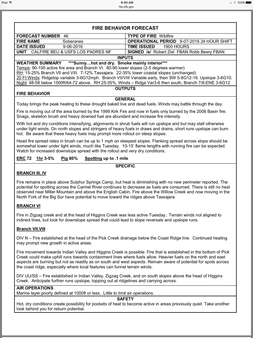
And here are the weather and fire behavior predictions.

imageimage


Flare up or Spot Fire Or?

5:00 pm – 2 type 1 tankers and the VLAT working the fire this afternoon. (VLAT = Very Large Air Tanker, often the DC-10 around here.)

And, just to make it interesting, there is a fire back on Pine Canyon Road, west of King City off of Jolon RD, in case we get bored.

4 pm – And from Howard Jones at Sky Ranch on the Carmel Valley side:

image

From USFS – a burn out operation, but man, the winds are kickin it up here.

image

3:20 pm – from here:

image

This is a new smoke plume on the north west side of Rancho San Carlos and the pager called for a full vegetation response with 2 WTs and a full strike team. This is the operations map of that area, zoomed in to show Williams Canyon which is where access is gained.

image

This is a photo of a plume (possibly this one?) taken by Howard Jones from Las Laureles Grade:

image


And this is one I just took from my place. This is a different plume, probably from the South Fork burn area. However,  in FRONT of the plume, there is drift smoke coming in from the right, or east of the frame, which is probably the other spot fire or flare up by William’s Canyon. And the white between me and Prewitt Ridge? Fog. It is windy here, but quite chilly for the first week of September.

Processed with Snapseed.
Plume and smoke behind Cone Peak by bigsurkate