4:30 pm – just spoke to the PIO on this fire, Jim, and he let me know that they were taking aDVANTAGE OF THE GOOD FLYING WEATHER TO BRING IN THE VLAT AND PRETREAT THE CONTAINMENT LINE FROM COLD SPRINGS TO ANDERSON PEAK, SO THEY CAN FIRE OFF WHEN IT IS ADVANTAGEOUS TO DO SO.
8:15 am –
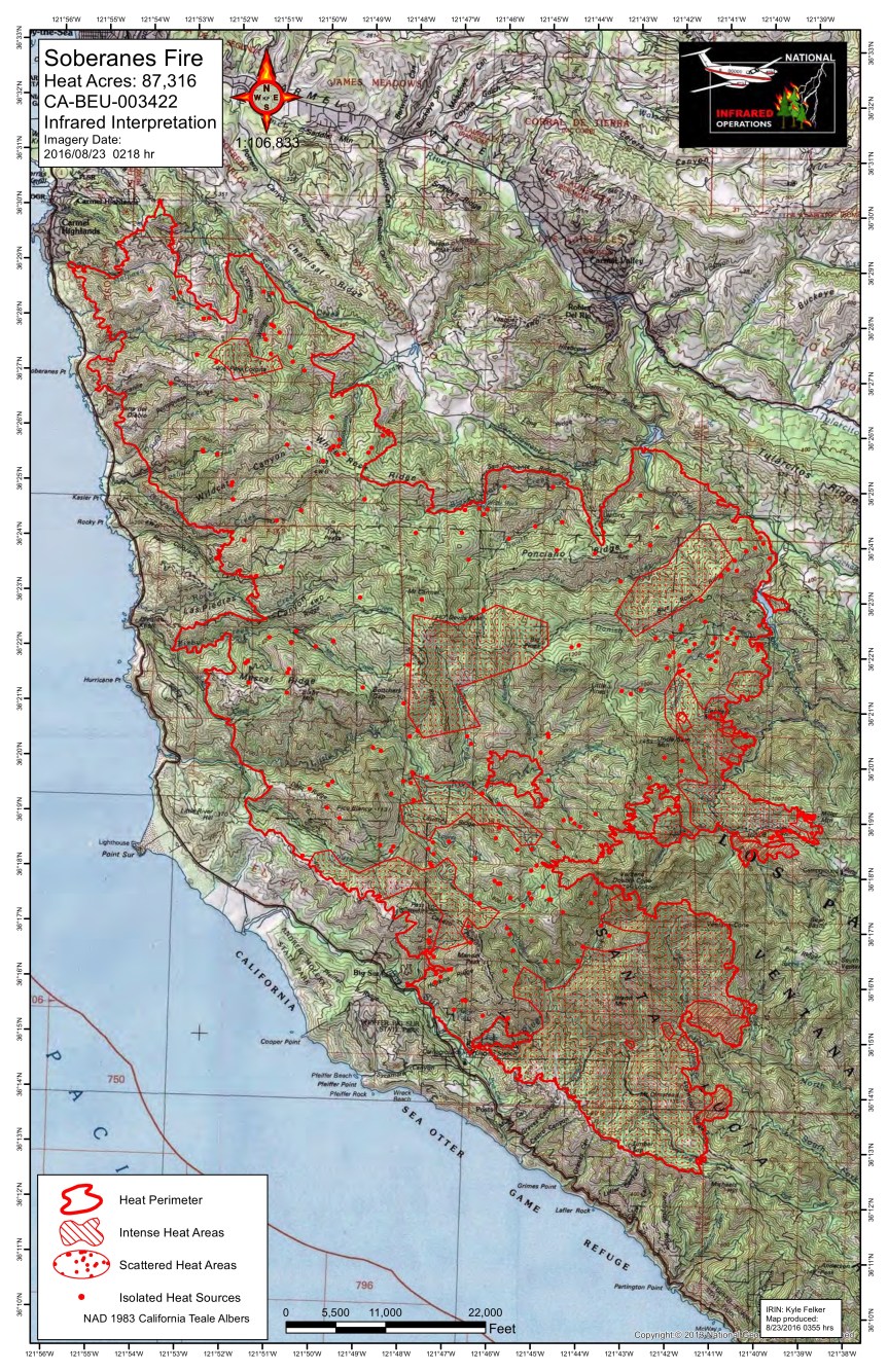
Soberanes Fire
Los Padres National Forest Service
August 24, 2016
DAILY UPDATE
Fire Information Phone (831)204-0446
soberanesfire2016@gmail.com
Media Line: (831)484-9647
http://inciweb.nwcg.gov/incident/4888/
http://www.fire.ca.gov/current_incidents/incidentdetails/Index/1348
Incident: The Soberanes Fire was started by an Illegal campfire on the morning of July 22, 2016, in the Garrapta State Park. The fire is burning in areas of previous large fires including the Basin Complex in 2008 and the Marble-Cone Fire in 1977.
Location: Los Padres National Forest, Ventana Wilderness, Monterey County, CA
Agency Jurisdiction: CAL FIRE San Benito-Monterey Unit/Los Padres National Forest
Current Size: 88654 (51,460 CA-LPF, 37,194 CAL FIRE,) Containment: 60% Cause: Illegal campfire
Injuries: 1 fatality, 4 injuries Structures Destroyed: 57 homes, 11 outbuildings Structures Threatened: 410
Current Resources: Crews: 20 Engines: 54 Helicopters: 12 Dozers: 22 Water Tenders: 42
Total Personnel: 1,620
Fire Restrictions: Forest Order 05-07-16-15 Fire Use Restrictions – Level IV Fire Restrictions. This Order is effective from August 23, 2016, through the end of the official 2016 fire season.
Community Meeting: A community meeting will be held at the Cachagua General Store, located at 18840 Cachagua Road, Carmel Valley, CA on Thursday, August 25, 2016 at 6:00 P.M.
Current Situation: The fire continues to move south and east of Miller Mountain in Hiding Camp Canyon, and farther south near the Ventana Cones. It has crossed Big Sur drainage below Mount Olmstead and remains within containment lines. Tomorrow’s marine layer is predicted to burn off mid-morning. This will produce the warmest temperatures of the week. Due to decreased humidity recovery through the night and drought conditions, fire behavior is expected to increase making aggressive runs up hill in the fire area. At present the fire is not expected to threaten the containment lines along Tassajara Road to the East or along Coast Ridge Road to the West.
The fire’s slow progress southward around Logwood Ridge is allowing firefighters to delay their tactical firing operations. Firing operations are only conducted when weather and conditions allow for its safe and effective use. Firefighters continue to widen and improve indirect containment lines east from Anderson peak to Santa Lucia Memorial Park and northward to Arroyo Seco. A Structure Protection Group has been formed to continue to assess and improve fire protection of structures within the projected growth of the fire.
Fire line repair continues in the Carmel Zone fire areas.
Wilderness Tactics: To reduce the impacts associated with fire suppression activities in wilderness areas, fire managers and firefighting crews continue using Minimum Impact Suppression Tactics as much as possible. The steep, rugged terrain of the Ventana Wilderness is inherently treacherous to firefighters. Most direct fireline is being constructed near the perimeter in areas that have been pretreated and supported by aircraft. The inaccessibility into the Ventana Wilderness along much of the fire’s east side continually requires patience, and slow and steady hard work from the crews, as they look for options to construct direct line.
The fire was caused by an illegal, unattended campfire on the Soberanes Canyon trail in the Garrapata State Park. Anyone with information is asked to call the CAL FIRE Tip Line at: (800) 468-4408. Fire managers want to remind the public that human caused fires are preventable. Please be aware of current fire restrictions and be careful with anything that could spark a fire.
US Forest Service Road and Trail Closures: A forest closure order has been implemented to close the trails and roads within the Los Padres National Forest, Monterey Ranger District pursuant to USC 551 and 36 CFR 261.50(a). The order prohibits going into or being upon National Forest System lands within the Soberanes Fire area. For a complete list of closures please visit: http://www.fs.usda.gov/lpnf . The following sites are open: Pfeiffer Beach Day Use, Mill Creek Day Use, Willow Creek Day Use, Sand Dollar Day Use, Kirk Creek Campground, Nacimiento Campground, Ponderosa Campground and Plaskett Creek Campground.
California State Park Closures: All California State Parks from Garrapata State Park through Julia Pfeiffer Burns State Park are closed until further notice; this includes Point Sur State Historic Park (Lighthouse), Andrew Molera State Park, Pfeiffer Big Sur State Park Campground and Day Use.
Evacuation Orders and Warnings: An evacuation ORDER remains in effect for Coast Ridge Rd. from mile marker 1.5 to Marble Peak at the end of the road. A WARNING remains for Tassajara Road from Carmel Valley Road to the Tassajara Hot Springs Zen Center. This area includes all roads that lead from the above described roads.
Donations: Local relief efforts to the fire victims have been provided by the Coast Property Owners Association (CPOA) and the Community Foundation for Monterey County. Donations can be made to the CPOA at Coast Property Owners Association, PO Box 59, Big Sur, CA 93920 or the Community Foundation for Monterey County, 2354 Garden Road, Monterey, CA 93940 (831)375-9712.
The Red Cross prepares for, responds to, and helps people recover from disasters big and small. To donate, people can visit redcross.org/donate/, call 800-RED CROSS (800-733-2767), or text REDCROSS to 90999 to make a $10 donation. For any unmet disaster related needs, please call their 24 hour hotline at 1.866.272.2237.
Additional Cooperating and Assisting Organizations: California State Parks and Recreation, California Highway Patrol California Office of Emergency Services , California Department of Corrections & Rehabilitation, California National Guard, Big Sur Land Trust, California Department of Transportation, California National Guard, California Fish & Wildlife, Coast Property Owners Association (CPOA), Community Foundation for Monterey County, Bureau of Land Management, American Red Cross, County of Monterey, Pacific Gas and Electric, Carmel Highlands F.P.D., Monterey County Regional Fire Protection District, Mid Coast Volunteer Fire Brigade, Big Sur Volunteer Fire Brigade and the Cachagua Fire Protection District.
####
7:00 am – And here are two photos of the burn out operation at Mt. Olmstead:

Above photo by Soaring

Above photo by Tommy McDonald
6:30 am – here are the maps. I have a couple good photos of the burn operation yesterday afternoon that I will add as soon as I get the maps up for the Chimney Fire.
the IR Topo Map and Link: