Chimney Fire, 8/23/15

7:30 pm – Facts sheet:

image

4:00 pm – Paso Robles Fairgrounds, photo by Joanne Latham Bklacford:

image

3:00 pm – According to one of my more reliable sources, this fire has entered the SE corner of FHL near Waterdog Creek. That is just above the finger of fire on the west just crossing into Monterey County.

image

If you want to do this yourself for a different part of the fire, go to the list of links to the right under 2016 Fire Season, then Current Wildland Fire Maps and click on that. You will have to search for the area you want, so, for example, if you are looking for Copperhead Road, search for the nearest area, such as Bryson Hesperia, CA.

1:45 pm – for those who have not seen this, here is a video taken by the Park Rangers Association of a boat navigating Nacimiento Lake with flames all around. It is short.

Video taken in boat on Lake Nacimiento

Here is an interesting map that will show you where this fire is in relation to most areas:

image

Incident Update
Date: 8/23/2016 Time: 6:00AM
Fire Information Line: 805-543-2444

STATUS
Incident Start Date: 8/13/2016 Incident Start Time: 4:03 PM
Incident Type: Vegetation Fire Cause: Under Investigation
Incident Location: Chimney Rock Rd. & Running Deer Rd., South of Nacimiento Reservoir

Acreage: 37,101 acres Containment: 35%
Expected Containment: 08/29/2016 Injuries: 1
Structures Threatened: 1,896
Structures Destroyed: Residences 36 Other 16
Structures Damaged: 7

RESOURCES
Engines: 326 Water Tenders: 62 Helicopters: 17 Air Tankers: 7 Hand Crews: 107
Dozers: 46 Other: 3 Total Personnel: 3,983
Cooperating Agencies: California Highway Patrol, California State Parks, San Luis Obispo County Sheriff, Red Cross, California
Department of Corrections and Rehabilitation, California Conservation Corps, PG&E, San Luis Obispo Air Quality Board, San Luis Obispo Public Works, Paso Robles Fire Department, Monterey Co. Water Resource Board, California Department of Fish and Wildlife, US Army Camp Roberts, CAL-OES, San Luis Obispo OES, Monterey County Sheriff, Monterey County OES and USFS.

SITUATION
Overnight, fire behavior remained extreme. The fire continued to burn in steep terrain, along with very dry brush and timber. Once the morning inversion dissipates, winds will increase out of the south to southwest at 10MPH with gusts  around 20MPH. Temperatures and relative humidity will become wide spread, with temperatures in the 70’s on the western perimeter, to readings in the 90’s east of Rocky Butte Truck Trail. Upper level winds will turn out of north to northwest today, which will allow for the smoke aloft to drift towards the south-southeast of the Chimney Fire. Threats remain to Oak Shores, Christmas Cove, South Shore Village, Rancho Del Lago, Cal Shasta, Bryson Hesperia and Lake San Antonio. As with all evacuation orders and warnings, these are implemented for the safety of the public and firefighters. Please adhere to all orders, warnings, road closures and detours. Fire personnel are working in extreme fire conditions around the clock to contain and control the fire. Please do you part to be prepared to evacuate by visiting http://www.readyforwildfire.org .
Evacuations:
Ordered: Evacuation orders are in place for Christmas Cove, Oak Shores, North Shore Boat and Ski, Laguna Vista, South Shore Village, Rancho Del Lago, Cal Shasta, Lake San Antonio, Sapaqua Valley, and Bryson Hesperia in both San Luis Obispo and Monterey Counties. Any residents that have yet to evacuate are asked to do so immediately due to increasing fire activity in your immediate area.

Evacuation Centers:
Flamson Middle School
2405 Spring Street
Paso Robles, CA 93446
Small Animals – Chimney Fire Animal Shelter can be contacted at (805)423-4934
Large Animals – Horse Emergency Evacuation Team (HEET) 805-466-7457
Large and Small Animals – Chimney Fire Animal Relief (805)423-4934
Road Closures: G14 Interlake Road from Lake Nacimiento Dam to Bryson Hesperia Road. Traffic control points are being manned by CHP at Interlake Road at Bryson Hesperia Road, as well as Interlake Road at Lake Nacimiento.
http://www.readyforwildfire.org

7:15 am – John Chesnut’s Map (the green line across is the MoCo/SLOCo line):

image

7:00 am – Here is the IR map for today to get us started. I need to go start my coffee (TMI, right?) and then I’ll be back Intel gathering. CAL FIRE reported Tuesday morning that the Chimney Fire grew nearly 4,000 acres overnight to 37,101 acres burned. Containment of the blaze remains at 35%. Here is the link to the IR Topo map:

Topo IR PDF Map Link

image

Soberanes Fire, Day 33, 8/23/15

1:30 pm – Firing Operation resumes today, still in Cold Springs area. Photo by Jeffrey Carmichael.

image

8:00 am –

Soberanes Fire
Los Padres National Forest Service
August 23, 2016

DAILY UPDATE

Fire Information Phone (831)204-0446
Media Line: (831)484-9647
Email: soberanesfire2016@gmail.com
http://inciweb.nwcg.gov/incident/4888/
http://www.fire.ca.gov/current_incidents/incidentdetails/Index/1348

Incident: The Soberanes Fire was started by an Illegal campfire on the morning of July 22, 2016, in the Garrapta State Park. The fire is burning in areas of previous large fires including the Basin Complex in 2008 and the Marble-Cone Fire in 1977.
Location: Los Padres National Forest, Ventana Wilderness, Monterey County, CA
Agency Jurisdiction: CAL FIRE San Benito-Monterey Unit/Los Padres National Forest

Current Size: 87,316 acres (50,122 CA-LPF, 37,194 CAL FIRE,) Containment: 60% Cause: Illegal campfire
Injuries: 1 fatality, 4 injuries Structures Destroyed: 57 homes, 11 outbuildings Structures Threatened: 410
Current Resources: Crews: 32 Engines: 60 Helicopters: 12 Dozers: 27 Water Tenders: 45
Total Personnel: 1,988

Community Meeting: A community meeting will be held at the Cachagua General Store, located at 18840 Cachagua Road, Carmel Valley, CA on Thursday, August 25, 2016 at 6:00 P.M.

Current Situation: The fire continues to slowly move south and east of Miller Mountain in Hiding Camp Canyon, and farther south near the Ventana Cones. Fire behavior remains a slow backing and flanking fire through an eight year old fuel bed of grass, brush and timber litter. Near the coast range, the fire continues to flank southward in the Big Sur drainage below Mount Olmstead. Aircraft was utilized yesterday to cool and slow the southward progression of the fire. At present, there is no threat to the completed indirect containment lines along Tassajara Road to the east nor along Coast Ridge Road to the west.

Firing operations have not occurred for several days. The fire’s slow progress southward around Logwood Ridge is allowing firefighters to delay their tactical firing operations. These firing operations allow firefighters safer conditions while creating containment lines east of Coast Ridge Road. Firing operations are only conducted when weather and conditions allow for safe and effective operations. Firefighters continue to widen and improve indirect containment lines east from Anderson peak to Santa Lucia Memorial Park and northward to Arroyo Seco. These indirect lines are built on the ridges that stopped the Basin Complex of 2008.

California Interagency Incident Management Team Three, CAL FIRE and cooperators wish to thank the California National Guard for their contributions and support of the team efforts on the Soberanes Fire.

Wilderness Tactics: To reduce the impacts associated with fire suppression activities in wilderness areas, fire managers and firefighting crews continue using Minimum Impact Suppression Tactics as much as possible. The steep, rugged terrain of the Ventana Wilderness is inherently treacherous to firefighters. Most direct fireline is being constructed near the perimeter in areas that have been pretreated and supported by aircraft. The inaccessibility into the Ventana Wilderness along much of the fire’s east side continually requires patience, and slow and steady hard work from the crews, as they look for options to construct direct line.

The fire was caused by an illegal, unattended campfire on the Soberanes Canyon trail in the Garrapata State Park. Anyone with information is asked to call the CAL FIRE Tip Line at: (800) 468-4408. Fire managers want to remind the public that human caused fires are preventable. Please be aware of current fire restrictions and be careful with anything that could spark a fire.

US Forest Service Road and Trail Closures: A forest closure order has been implemented to close the trails and roads within the Los Padres National Forest, Monterey Ranger District pursuant to USC 551 and 36 CFR 261.50(a). The order prohibits going into or being upon National Forest System lands within the Soberanes Fire area. For a complete list of closures please visit: http://www.fs.usda.gov/lpnf . The following sites are open: Pfeiffer Beach Day Use, Mill Creek Day Use, Willow Creek Day Use, Sand Dollar Day Use, Kirk Creek Campground, Nacimiento Campground, Ponderosa Campground and Plaskett Creek Campground.

California State Park Closures: All California State Parks from Garrapata State Park through Julia Pfeiffer Burns State Park are closed until further notice; this includes Point Sur State Historic Park (Lighthouse), Andrew Molera State Park, Pfeiffer Big Sur State Park Campground and Day Use.

Evacuation Orders: An evacuation ORDER remains in effect for Coast Ridge Rd. from mile marker 1.5 to Marble Peak at the end of the road.

Evacuation Warnings: A WARNING remains for Tassajara Road from Carmel Valley Road to the Tassajara Hot Springs Zen Center. This area includes all roads that lead from the above described roads.

Donations: Local relief efforts to the fire victims have been provided by the Coast Property Owners Association (CPOA) and the Community Foundation for Monterey County. Donations can be made to the CPOA at Coast Property Owners Association, PO Box 59, Big Sur, CA 93920 or the Community Foundation for Monterey County, 2354 Garden Road, Monterey, CA 93940 (831)375-9712.

The Red Cross prepares for, responds to, and helps people recover from disasters big and small. To donate, people can visit redcross.org/donate/, call 800-RED CROSS (800-733-2767), or text REDCROSS to 90999 to make a $10 donation. For any unmet disaster related needs, please call their 24 hour hotline at 1.866.272.2237.

Additional Cooperating and Assisting Organizations: California State Parks and Recreation, California Highway Patrol California Office of Emergency Services , California Department of Corrections & Rehabilitation, California National Guard, Big Sur Land Trust, California Department of Transportation, California National Guard, California Fish & Wildlife, Coast Property Owners Association (CPOA), Community Foundation for Monterey County, Bureau of Land Management, American Red Cross, County of Monterey, Pacific Gas and Electric, Carmel Highlands F.P.D., Monterey County Regional Fire Protection District, Mid Coast Volunteer Fire Brigade, Big Sur Volunteer Fire Brigade and the Cachagua Fire Protection District.
This electronic message contains information generated by the USDA solely for the intended recipients. Any unauthorized interception of this message or the use or disclosure of the information it contains may violate the law and subject the violator to civil or criminal penalties. If you believe you have received this message in error, please notify the sender and delete the email immediately.

7:15 am – John Chesnut’s Map:

image

7:00 am – Here is a aborted water drop last night near Lower Stone Ridge after a bucket at Rancho Grande, Photo by Jane Magida (the bucket got tangled in the pick up)

image

6:30 am – Here are a couple of the maps and their links:

image

Topo PDF map link

image

So Ops PDF Map Link

Chimney Fire, 8/22/16

This came in at 7, but I was watching a movie, and then I couldn’t get my internet up and running properly, but here it is at long last:

CHIMNEY FIRE, 7 P.M. MONDAY, AUG. 22.
The fire situation is reportedly very dynamic tonight, especially in the Lake Nacimiento area. The information below likely was compiled during a rapid onslaught of fire that reportedly destroyed a number of homes in the South Shore Village area.

Chimney Fire
Incident Update
Date: 8/22/2016 Time: 6:00PM
Fire Information Line: 805-543-2444

STATUS
Incident Start Date: 8/13/2016 Incident Start Time: 4:03 PM
Incident Type: Vegetation Fire Cause: Under Investigation
Incident Location: Chimney Rock Rd. & Running Deer Rd., South of Nacimiento Reservoir

Acreage: 33,173 acres Containment: 35%
Expected Containment: 08/29/2016 Injuries: 1
Structures Threatened: 1,898

Structures Destroyed:
Residences 36 (up from 34 this morning).
Other 16 (up from 14 this morning).
Structures Damaged: 7

RESOURCES
Engines: 311 Water Tenders: 46 Helicopters: 17 Air Tankers: 7 Hand Crews: 104
Dozers: 46 Other: 3 Total Personnel: 3,813
Cooperating Agencies: California Highway Patrol, California State Parks, San Luis Obispo County Sheriff, Red Cross, California
Department of Corrections and Rehabilitation, California Conservation Corps, PG&E, San Luis Obispo Air Quality Board, San Luis Obispo Public Works, Paso Robles Fire Department, Monterey Co. Water Resource Board, California Department of Fish and Wildlife, US Army Camp Roberts, CAL-OES, San Luis Obispo OES, Monterey County Sheriff, Monterey County OES and USFS.

SITUATION
Current Situation:
Today, fire behavior was extreme and continued to challenge the control lines. The fire is currently burning through Rocky Butte area and into Monterey County west of Lake San Antonio. Threats remain to Oak Shores, Christmas Cove, South Shore Village, Rancho Del Lago, Cal Shasta, Bryson Hesperia and Lake San Antonio.
Once the morning inversion broke, the winds increased out of the southwest at 10 mph with gusts out of the south
around 20 mph. Damage assessment is ongoing.
As with all evacuation orders and warnings, these are
implemented for the safety of the public and firefighters. Please adhere to all orders, warnings, road closures and detours. Fire personnel are working in extreme fire conditions around the clock to contain and control the fire.
Please do your part to be prepared to evacuate by visiting http://www.readyforwildfire.org .
Evacuations:
Ordered: Evacuation orders are in place for Christmas Cove, Oak Shores, North Shore Boat and Ski, Laguna Vista, South Shore Lake San Antonio, Sapaqua Valley, and Bryson Hesperia in both San Luis Obispo and Monterey Counties. Any residents that have yet to evacuate are asked to do so immediately due to increasing fire activity in your immediate area.
Evacuation Centers:
Flamson Middle School
2405 Spring Street
Paso Robles, CA 93446
Small Animals – Chimney Fire Animal Shelter can be contacted at (805)423-4934
Large Animals – Horse Emergency Evacuation Team (HEET) 805-466-7457
Large and Small Animals – Chimney Fire Animal Relief (805)423-4934
Road Closures: G14 Interlake Road from Lake Nacimiento Dam to Bryson Hesperia Road. Traffic control points are being
manned by CHP at Interlake Road at Bryson Hesperia Road, as well as Interlake Road at Lake Nacimiento.

For updates, check at http://www.sanluisobispo.com

5:00 pm – from FHL: “Interlake Rd is closed from Lake Nacimiento Dam to Bryson Hesperia Rd due to Chimney Fire. CHP is conducting traffic control. Expect More road closures. Call CALFIRE at (805) 242-3640 or 831-386-2513 for updates. Please drive safely and allow emergency response vehicles pass.”

http://www.fire.ca.gov/current_incidents/incidentdetails/Index/1389

4:30 pm – from a friend: “Hi Kate I’m on my property off Bryson Hisperia Rd a little past the Hisperia/ Smith road turn off. Fire is in the bottom of the creek to the west of us in Forest River that’s where they are keeping it from jumping Bryson Hisperia road. Just an up date for you”

3:45 pm – 3 fully involved structure fires in Oak Shores, per Div. M

3:00 pm –

CAL FIRE NEWS RELEASE
California Department of Forestry and Fire Protection
CONTACT: INFORMATION LINE
RELEASE DATE: August 22, 2016
(805) 543-2444 TIME: 2:00 p.m.
CHIMNEY FIRE:

EVACUATION ORDERS:
This message is to reinforce that evacuation orders are in place for
Christmas Cove, Oak Shores, North Shore Boat and Ski, Laguna Vista, South Shore Lake San Antonio, Sapaqua Valley, and Bryson Hesperia in both San Luis Obispo and Monterey Counties.
Any residents that have yet to evacuate are asked to do so immediately due to increasing fire activity in your immediate area.
ROAD CLOSURES: G14 Interlake Road from Lake Nacimiento Dam to Bryson Hesperia Road. Traffic control points are being manned by CHP at Interlake Road at Bryson Hesperia Road, as well as Interlake Road at Lake Nacimiento.
When you evacuate be sure to take any medications, pets, family valuables etc. with you, close all windows including window coverings, and leave all doors closed.
All residents are asked to be READY: Create and maintain defensible space and harden your home against flying embers. Get SET: Prepare your family and home ahead of time for the possibility of having to evacuate.
Be Ready to GO! Take the evacuation steps necessary to give your family and home the best chance of surviving a wildfire.
For more information on Ready, Set, Go, go to http://www.readyforwildfire.org
For additional information on the Chimney Fire, please call the
Information Line at (805) 543-2444. Or visit CAL FIRE online @
http://www.fire.ca.gov
###

7:30 am – Here are John Chesnut’s maps – two from different angles:

imageimage

7:00 am – This morning the total acreage is given as 31,644 and containment is still 35%. You will note that this fire crept into Monterey County last night.

IR Ortho Map:

image


Soberanes Fire, Day 32, 8/22/16

5:15 pm –

Pfeiffer Beach opened this morning at 10:00 AM and will be on its regular schedule, 10:00 AM – 6:00 PM.

Here’s the rundown of State Park closures / expected reopenings:

-The West side of Garrapata has been open during the fire and remains open. East of the highway the park will remain closed for the foreseeable future.
– Point Sur Light Station SHP is scheduled to reopen this weekend with normal hours.
– Andrew Molera SP will remain in use as a Fire Camp for the foreseeable future.
– Pfeiffer Big Sur SP will remain closed at least through Sept 5th. The Fire Camp is currently moving out, and Parks has begun necessary work to reopen. We have not set a date yet, and expect the work to take at least 2 to 3 weeks.
– Julia Pfeiffer Burns SP is targeted for a partial reopening Thursday the 25th, which will include the parking lot and trails west of Highway 1. The eastern trails will remain closed.

Thank You,

Eric Abma
California State Parks
Deputy District Superintendent (Acting)

3:30 pm – Helicopters flying from Andrew Molera by Jen Smith

image

10:00 am – Status Report
August 22, 2016
DAILY UPDATE
Fire Information Phone (831)204-0446 soberanesfire2016@gmail.com
Media Line: (831)484-9647
http://inciweb.nwcg.gov/incident/4888/
http://www.fire.ca.gov/current_incidents/incidentdetails/Index/1348

Incident: The Soberanes Fire was started by an Illegal campfire on the morning of July 22, 2016, in the Garrapta State Park. The fire is burning in areas of previous large fires including the Basin Complex in 2008 and the Marble-Cone Fire in 1977.
Location: Los Padres National Forest, Ventana Wilderness, Monterey County, CA
Agency Jurisdiction: CAL FIRE San Benito-Monterey Unit/Los Padres National Forest
Additional Cooperating and Assisting Organizations: CA State Parks and Recreation, CHP, CAL-OES, CDCR, CA National Guard, Big Sur Land Trust, CAL-TRANS, CCC, CA Fish & Wildlife, Coast Property Owners Association (CPOA), Community Foundation for Monterey County, BLM, American Red Cross, the County of Monterey, PG&E, Carmel Highlands F.P.D., Monterey County Regional Fire Protection District, Mid Coast Volunteer Fire Brigade, Big Sur Volunteer Fire Brigade and the Cachagua Fire Protection District.

Current Size: 86,294 acres (49,100 CA-LPF, 37,194 CAL FIRE,) Containment: 60% Cause: Illegal campfire
Injuries: 1 fatality, 3 injuries Structures Destroyed: 57 homes, 11 outbuildings Structures Threatened: 410
Current Resources: Crews: 34 Engines: 60 Helicopters: 13 Dozers: 29 Water Tenders: 29
Total Personnel: 2109

Current Situation: Today marks day thirty of the Soberanes Fire. Nominal growth occurred the last twenty four hours of 1,082 acres. The fire continues to slowly burn interior islands with heavier fuels within the Ventana Wilderness portions of the fire. No movement outside the fireline is expected in this area. Crews continue to patrol and extinguish hot spots with their primary focus on suppression repair.

On the east side, the fire advanced towards Miller Mountain and Ventana Cone. Firefighters continue to prepare and reinforce contingency lines from the Los Padres Reservoir to Chews Ridge. Lines are also being strengthened from Arroyo Seco south to Santa Lucia Memorial Park. Crew have provided enhanced protection measures to structures within the predicted path of the Soberanes Fire in the Ventana Wilderness.

Near the Big Sur area, no firing operations occured yesterday but may occur today if conditions are favorable. Aircraft was utilized yesterday to slow the southward progression of the fire. Most of the fire activity occurred east of Barlow Camp and west of Redwood Creek Camp, flanking to the south in the Big Sur River drainage area. The fire is established on Logwood Ridge. Crews are working hard to reinforce hand-line along portions of Logwood Ridge where possible.

Wilderness Tactics: To reduce the impacts associated with fire suppression activities in wilderness areas, fire managers and firefighting crews continue using MIST (Minimum Impact Suppression Tactics) as much as possible. The steep, rugged terrain of the Ventana Wilderness is inherently treacherous to firefighters. Most direct fireline is being constructed near the perimeter in areas that have been pretreated and supported by aircraft. The inaccessibility into the Ventana Wilderness along much of the fire’s east side continually requires patience, and slow and steady hard work from the crews, as they look for options to construct direct line.

The fire was caused by an illegal, unattended campfire on the Soberanes Canyon trail in the Garrapata State Park. Anyone with information is asked to call the CAL FIRE Tip Line at: (800) 468-4408.

Fire managers want to remind the public that human caused fires are preventable. Please be aware of current fire restrictions and be careful with anything that could spark a fire.

US Forest Service Road and Trail Closures: A forest closure order has been implemented to close the trails and roads within the Los Padres National Forest, Monterey Ranger District pursuant to USC 551 and 36 CFR 261.50(a). The order prohibits going into or being upon National Forest System lands within the Soberanes Fire area. The Arroyo Seco Campground and Day Use Area is closed. For a complete list of closures please visit: http://www.fs.usda.gov/lpnf
California State Park Closures: All California State Parks from Garrapata State Park through Julia Pfeiffer Burns State Park are closed until further notice; this includes Point Sur State Historic Park (Lighthouse), Andrew Molera State Park, Pfeiffer Big Sur State Park Campground and Day Use.
Evacuation Orders: An evacuation ORDER remains in effect for Coast Ridge Rd. from mile marker 1.5 to Marble Peak at the end of the road.
Evacuation Warnings: A WARNING remains for Tassajara Road from Carmel Valley Road to the Tassajara Hot Springs Zen Center. This area includes all roads that lead from the above described roads.
Donations: Local relief efforts to the fire victims have been provided by the Coast Property Owners Association (CPOA) and the Community Foundation for Monterey County. Donations can be made to the CPOA at Coast Property Owners Association, PO Box 59, Big Sur, CA 93920 or the Community Foundation for Monterey County 2354 Garden Road, Monterey, CA 93940 (831)375-9712.

7:30 am –

Here is John Chestnut’s Map:

image

7:00 am – here is this morning’s IR Ortho Map, showing a total of 86,294 acres burned so far. Containment is the same, 60%.

image

Here is the Southern Operations Map for today and the link to the PDFs is here:

South Ops PDF link

image

Chimney Fire, 8/21/16

From John Chesnut:

imageimage

Here is the facts sheet:

For text alerts – text “follow @CAL_FIRE” to 40404
STATUS
Incident Start Date: 08/13/2016 Incident Start Time: 4:03 PM
Incident Type: Vegetation Fire Cause: Under Investigation
Incident Location: Chimney Rock Rd & Running Deer Rd, South of Nacimiento Reservoir
Acres/Size: 24,096 acres Containment: 35%
Expected Containment: 08/29/2016 Injuries: 1
Chimney Fire
Incident Update Sheet
Date: 8/21/2016 Time:7:00 A.M.
Fire Information Line: 805-543-2444
Media Line: 805-242-3640
Structures Threatened: 332 Structures Destroyed: 48 Structures Damaged: 7
RESOURCES
Engines: 224 Water Tenders: 45 Helicopters: 14 Air Tankers: 7 Hand Crews: 76
Dozers: 47 Other: 3 Total Personnel: 2,938
Assisting Agencies: California Highway Patrol, San Luis Obispo County Sheriff, Red Cross, California Department of
Corrections and Rehabilitation, California Conservation Corps, PG&E, San Luis Obispo Air Quality Board, San Luis Obispo
Public Works, Paso Robles Fire Department, Monterey Co. Water Resource Board, California Department of Fish and
Wildlife, US Army Camp Roberts, CAL-OES, San Luis Obispo OES, and USFS.
Current
Situation:
Overnight, fire behavior remained extreme. Dry and drought stressed timber, chaparral, and grass in the steep
inaccessible terrain continue to challenge control lines. The fire continues to move north and west in steep terrain
and drought stressed vegetation.
Evacuations: Order: Communities under the order in San Luis Obispo County are Cal Shasta, Rancho de Lago, South Shore
Village, Christmas Cove, Oak Shores. Bryson Hesperia in both San Luis Obispo and Monterey County.
Evacuation Shelters
San Luis Obispo County – Flamson Middle School
2405 Spring St.
Paso Robles, CA 93446.
Monterey County – Red Cross Evacuation Center
Lockwood Community Center
65961 Lockwood / San Lucas Rd.
Lockwood, CA 93932
Small Animals – Chimney Fire Animal Shelter can be contacted at (805)423-4934
Large Animals – Horse Emergency Evacuation Team (HEET) 805-466-7457
Large and Small Animials – Chimney Fire Animal Relief (805)423-4934
Road Closures: At the intersection of G14(Tierra Redonda) at Lynch Canyon Rd. No traffic west of G14(Tierra Redonda) on Lynch
Canyon.
Additional
Information:
With summer weather and extreme drought conditions, we are asking everyone to continue to use caution, “one
less spark – one less wildfire”. For more information on how to prepare for wildfires, go to
http://www.readyforwildfire.org. For more information visit the Cal FIRE website at http://www.fire.ca.gov
http://www.fire.ca.gov

Here is the IR Log for last night/early this am:

image

Here is the IR flight map, which can be found here for downloading:

IR Flight Map

image

Here is the progression of the fire since it began:

image


And finally for the operations map:

image


Soberanes Fire, Day 31, 8/21/16

Evacuation warning lifted for east side of Highway One:

Soberanes Fire
Los Padres National Forest
August 21, 2016

Salinas, Calif., August 21, 2016, 6:00 p.m.—For Immediate Release.
Evacuation warnings have lifted for the east side of Highway 1 from Andrew Molera State Park to Coast Ridge Road at the Ventana Inn. This includes the Ventana Inn and Coast Ridge Road to 1.5 miles above Ventana Inn.

Evacuation orders remain in effect for Coast Ridge Road from 1.5 miles above the Ventana Inn to the end of Coast Ridge Road at Marble Peak, and roads that leave from Coast Ridge Road.

Evacuation warnings remain in effect from the Tassajara Road from Carmel Valley to the Tassajara Hot Springs Zen Center, and roads that leave from Tassajara Road.

Many communities surrounding Monterey County have been effected by evacuation warnings and orders since July 22, 2016 when an illegal campfire ignited the Soberanes Fire.

The USDA Forest Service, CAL FIRE, and cooperators would like to thank the public for their continued cooperation and understanding during the warnings and evacuations. Fire managers continue to monitor the need for evacuations based on current and expected fire behavior.

For additional information or details regarding the Soberanes Fire, please contact the Soberanes Fire Information Line at (831) 204-0446.

####

Here is  John Chesnut’s Map:

image

8:30 am – Here is the USFS AM Report

August 21, 2016
DAILY UPDATE
Fire Information Phone (831)204-0446 soberanesfire2016@gmail.com
Media Line: (831)484-9647
http://inciweb.nwcg.gov/incident/4888/
http://www.fire.ca.gov/current_incidents/incidentdetails/Index/1348

Incident: The Soberanes Fire was started by an Illegal campfire on the morning of July 22, 2016, in the Garrapta State Park. The fire is burning in areas of previous large fires including the Basin Complex in 2008 and the Marble-Cone Fire in 1977.
Location: Los Padres National Forest, Ventana Wilderness, Monterey County, CA
Agency Jurisdiction: CAL FIRE San Benito-Monterey Unit/Los Padres National Forest
Additional Cooperating and Assisting Organizations: CA State Parks and Recreation, CHP, CAL-OES, CDCR, CA National Guard, Big Sur Land Trust, CAL-TRANS, CCC, CA Fish & Wildlife, Coast Property Owners Association (CPOA), Community Foundation for Monterey County, BLM, American Red Cross, the County of Monterey, PG&E, Carmel Highlands F.P.D., Monterey County Regional Fire Protection District, Mid Coast Volunteer Fire Brigade, Big Sur Volunteer Fire Brigade and the Cachagua Fire Protection District.

Current Size: 83,830 acres (37,194 CA-LPF, 48,018 CAL FIRE,) Containment: 60% Cause: Illegal campfire
Injuries: 1 fatality, 3 injuries Structures Destroyed: 57 homes, 11 outbuildings Structures Threatened: 410
Current Resources: Crews: 48 Engines: 64 Helicopters: 13 Dozers: 29 Water Tenders: 48
Total Personnel: 2421

Current Situation: With an increase of 1,382 acres, the Soberanes Fire was most active near and continues to progress slowly toward Buckskin Flat. It crossed the Carmel River about one mile south of Buckskin Flat Campground, 2 miles northeast of Hiding Canyon and 5 miles west of Chews Ridge. Firefighters continue their efforts building and strengthening existing control lines spanning from the Los Padres Reservoir to Chews Ridge. Due to the well-known ruggedness and inaccessibility along most of the fire’s east side in the Ventana Wilderness, crews continue to spike (camping near the fire front) out, scouting for options for direct line to restrict fire spread where possible.

The northern portion of the fire in the Carmel Valley area remains quiet and crews are expected to be in suppression repair for a couple more weeks.

In the immediate Big Sur area, firefighters are mopping up and beginning repair of fire suppression efforts. No firing operations took place on the fire yesterday but aircraft were utilized on the fire’s perimeter southeast of Big Sur, to cool and slow the fire’s edge.

Firefighters are taking protective action to defend against the slowly advancing Sobranes Fire in the Ventana Wilderness. The English cabin once owned by Jack English a local mountain man and resident, near Pine Flat has been protected with fire-resistant wrap. Dozer line has been constructed around the Church Ranch, and to preserve cultural sites and protect houses near Chews Ridge, areas have been brushed and positioned with hose lays and water pumps. Additional protective action will be taken if deemed necessary.

Wilderness Tactics: To reduce the impacts associated with fire suppression activities in wilderness areas, fire managers and firefighting crews continue using MIST (Minimum Impact Suppression Tactics) as much as possible. The steep, rugged terrain of the Ventana Wilderness is inherently treacherous to firefighters. Most direct fireline is being constructed near the perimeter in areas that have been pretreated and supported by aircraft.

The fire was caused by an illegal, unattended campfire on the Soberanes Canyon trail in the Garrapata State Park. Anyone with information is asked to call the CAL FIRE Tip Line at: (800) 468-4408.

US Forest Service Road and Trail Closures: A forest closure order has been implemented to close the trails and roads within the Los Padres National Forest, Monterey Ranger District pursuant to USC 551 and 36 CFR 261.50(a). The order prohibits going into or being upon National Forest System lands within the Soberanes Fire area. The Arroyo Seco Campground and Day Use Area is closed. For a complete list of closures please visit: http://www.fs.usda.gov/lpnf

California State Park Closures: All California State Parks from Garrapata State Park through Julia Pfeiffer Burns State Park are closed until further notice; this includes Point Sur State Historic Park (Lighthouse), Andrew Molera State Park, Pfeiffer Big Sur State Park Campground and Day Use.

Evacuation Orders: An evacuation ORDER remains in effect for Coast Ridge Rd. from mile marker 1.5 to Marble Peak at the end of the road.

Evacuation Warnings: Evacuation WARNINGS remain in effect for the east side of HWY 1 from Andrew Molera Park to Coast Ridge Rd at the Ventana Inn. This area includes the Ventana Inn and Coast Ridge Rd to mile marker 1.5. A WARNING remains for Tassajara Road from Carmel Valley Road to the Tassajara Hot Springs Zen Center. This area includes all roads that lead from the above described roads.

7 am – here is today’s IR Topo Map, showing 85,211 acres burned. I’ll add links underneath this map each day so you can obtain and/or see additional maps:

image

IR Topo Map

IR Ortho Map

South Ops Map

(When you click on the above, you will see a “pull-down” with the full link contained in it, click on that and you will get to the map you seek)


Soberanes Fire, Day 30, 8/20/16 – Local Reports

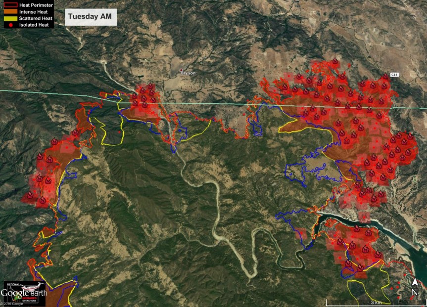
3:30 pm – the Chimney Fire has blown up and is threatening the Castle on the West, and the Southern Boundary of FHL on the East. It is spotting up to  a mile or more away. All of my energies are directed there right now, while I have my head on a swivel, but the really dark stuff is SE of me. For info, go to the Chimney Fire post, below this one

8:45 am – an interesting press release from the USFS this am, with more location specific information. I hope this is what we will get each morning.
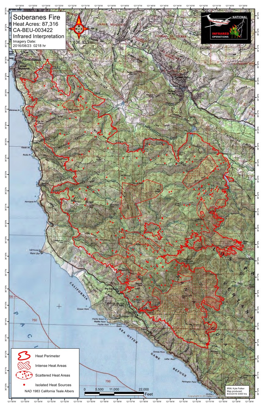
Soberanes Fire
Los Padres National Forest Service
August 20, 2016
DAILY UPDATE
Fire Information Phone (831)204-0446 soberanesfire2016@gmail.com
Media Line: (831)484-9647
http://inciweb.nwcg.gov/incident/4888/
http://www.fire.ca.gov/current_incidents/incidentdetails/Index/1348

Incident: The Soberanes Fire was started by an Illegal campfire on the morning of July 22, 2016, in the Garrapta State Park. The fire is burning in areas of previous large fires including the Basin Complex in 2008 and the Marble-Cone Fire in 1977.
Location: Los Padres National Forest, Ventana Wilderness, Monterey County, CA
Agency Jurisdiction: CAL FIRE San Benito-Monterey Unit/Los Padres National Forest
Additional Cooperating and Assisting Organizations: CA State Parks and Recreation, CHP, CAL-OES, CDCR, CA National Guard, Big Sur Land Trust, CAL-TRANS, CCC, CA Fish & Wildlife, Coast Property Owners Association (CPOA), Community Foundation for Monterey County, BLM, American Red Cross, the County of Monterey, PG&E, Carmel Highlands F.P.D., Monterey County Regional Fire Protection District, Mid Coast Volunteer Fire Brigade, Big Sur Volunteer Fire Brigade and the Cachagua Fire Protection District.

Current Size: 83,830 acres (46,636 CA-LPF, 37,194 CAL FIRE,) Containment: 60% Cause: Illegal campfire
Injuries: 1 fatality, 3 injuries Structures Destroyed: 57 homes, 11 outbuildings Structures Threatened: 410
Current Resources: Crews: 48 Engines: 65 Helicopters: 13 Dozers: 32 Water Tenders: 50
Total Personnel: 2500

The Soberanes Fire remains in unified command with CAL FIRE San Benito-Monterey Unit and the USDA Forest Service.

Current Situation: The Soberanes Fire has increased 2,434 acres, with most growth occurring between Double Cone and Uncle Sam Mountain. Firefighters continue their efforts building and improving existing control lines spanning from the Los Padres Reservoir to Chews Ridge. Due to inaccessibility along most of the fire’s east side, some crews have been temporarily spiked (camping near the fire front) out, scouting for options for direct line to restrict fire spread where possible.

East of Big Sur, the fire has burned toward Logwood Ridge where the fire continues to be the most active, though growth remains minimal in this area. Gusty afternoon north to northwest winds along with poor overnight humidity recovery, keeps the fire dynamic in the Sur Zone. Crews are working around the clock operations in this zone. Burning operations are only utilized during the day shift and when conditions are favorable. Aviation resources are assisting with keeping the fire in check.
There has been no active fire in the north for several days though interior heat still remains. Crews continue suppression repair work. Patriot Camp in Greenfield has been demobilized as of Friday, August 19.

Wilderness Tactics: To reduce the impacts associated with fire suppression activities in wilderness areas, crews continue using MIST (Minimum Impact Suppression Tactics) as much as possible. The steep and rugged terrain of the Ventana Wilderness is inherently treacherous to firefighters. Most direct fireline is being constructed near the perimeter in areas that have been pretreated and supported by aircraft.

Anyone with information regarding the cause of the Soberanes Fire is asked to call the CAL FIRE Tip Line at: (800) 468-4408.

US Forest Service Road and Trail Closures: A forest closure order has been implemented to close the trails and roads within the Los Padres National Forest, Monterey Ranger District pursuant to USC 551 and 36 CFR 261.50(a). The order prohibits going into or being upon National Forest System lands within the Soberanes Fire area. The Arroyo Seco Campground and Day Use Area is closed. For a complete list of closures please visit: http://www.fs.usda.gov/lpnf

California State Park Closures: All California State Parks from Garrapata State Park through Julia Pfeiffer Burns State Park are closed until further notice; this includes Point Sur State Historic Park (Lighthouse), Andrew Molera State Park, Pfeiffer Big Sur State Park Campground and Day Use.

Evacuation Orders: An evacuation ORDER remains in effect for Coast Ridge Rd. from mile marker 1.5 to Marble Peak at the end of the road.

Evacuation Warnings: Evacuation WARNINGS remain in effect for the east side of HWY 1 from Andrew Molera Park to Coast Ridge Rd at the Ventana Inn. This area includes the Ventana Inn and Coast Ridge Rd to mile marker 1.5. A WARNING remains for Tassajara Road from Carmel Valley Road to the Tassajara Hot Springs Zen Center. This area includes all roads that lead from the above described roads.

Donations: Local relief efforts have been provided by the Coast Property Owners Association (CPOA) and the Community Foundation for Monterey County have provided to the fire victims of the Sobranes
Fire. Donations can be made to the CPOA at Coast Property Owners Association, PO Box 59, Big Sur, CA 93920 and the Community Foundation for Monterey County 2354 Garden Road, Monterey, CA 93940 (831)375-9712.

The American Red Cross is very grateful for the offers of assistance, but at this time we are not able to accept in-kind donations such as food and clothing. If people have questions about in-kind donations related to the Soberanes Fire, they should contact MontereyCo.Recovers.org, which is a local web site that matches people who have supplies and other in-kind donations with people who have those same needs. To list an item that could be donated or to list a need, individuals are asked to submit that information on the organization’s web site:montereyco.recovers.org/. The organization’s phone number is 831-649-3050. People can help those affected by disasters by making a gift to American Red Cross Disaster Relief. These donations enable the Red Cross to prepare for, respond to, and help people recover from disasters big and small. To donate, people can visit redcross.org/donate/, call 800-RED CROSS (800-733-2767), or text REDCROSS to 90999 to make a $10 donation.

The American Red Cross Resource Center is open 10 am to 3 pm at 8th Ave. at Dolores St. SE, Carmel (831) 626-5256 thru Fri., August 19th. For any unmet disaster related needs please call our 24 hour hotline at 1.866.272.2237.
####

(In future postings of this media release,  I will be removing donations info to keep the post a bit shorter.)

**************************************************************************
This electronic message contains information generated by the USDA solely for the intended recipients. Any unauthorized interception of this message or the use or disclosure of the information it contains may violate the law and subject the violator to civil or criminal penalties. If you believe you have received this message in error, please notify the sender and delete the email immediately.

7:00 am – Today, more firing out operations behind Partington Ridge can be expected. It is anticipated that this may be the last such needed in this area,  as the fire makes its way south, away from populated areas. I am expecting a report later on today from a local who will be going to have a look at the operations to see how things are progressing.

As this fire enters its second month, it is burning away from the occupied areas and into the wilderness areas. While daily … And throughout the day … reporting has been helpful to all of us to find out what was going on with the fire with the wonderful first hand accounts of those who had eyes and cameras on it; as well as the maps and links that Lucas Ryan provided all of us for almost 3 weeks now; as the fire winds down, so does the need for the constant reporting. I will probably start a new format tomorrow, of a single post for several days, as I have been doing for the Chimney Fire. I will include the links to the maps, and perhaps the IR map, if available. If warranted, Lucas and I are ready to come back in with full reporting, but I don’t anticipate that being necessary.

My personal gratitude goes out to all the firefighters and support personnel who took this community into its collective heart, and protected us so well. We are still here for you, and will be until you go on to your next assignment or home. Kathleen Lee, of Dave Potter’s Office has gone so far above and beyond any duty she has felt to help communications between the Command Structure and the Local Communityk, it is hard to find the words which express that thankfulness. We are so thankful for her sweet caring. To all of you in this community who shared stories, photos, help, strength, and support; we are like no other. We are blessed to be here, and because of the hardships, we are stronger and closer to one another – not just Big Sur, but Cachagua as well. And finally, to Lucas, who came in on Day 8 of the fire to help me in the background and then only 2 days later, jumping in to create the maps post for me by obtaining (and making them look good) the maps that were essential to understanding the progress of the fire. Your assistance was invaluable to me. Thank you.

The fire is not over, nor is my coverage of it, but the need for the constant coverage has lessened, and we will all start to go back to whatever routine or lives we can rebuild from the venture we have endured. It has my honor and privilege to be a part of such a wonderful collaboration of efforts – the dream I had for this blog when I started – in the blessings of this unique, loving, and strong community.

And to top it off:

image


Soberanes Fire, Day 29, 8/19/16 – Local Reports

7:30 pm – haven’t gotten the evening report, yet, but I am not sure I can wait up for it. Today, I only saw the sun once. It was blood red. The rest of the day was gray and smokey – a depressing kind of day, a day when I realized this may be the new “normal” for California in the summer, unless we do something. If Mother Nature does not end our 5-year drought soon, this is what we have to look forward to. I feel for my grandchildren.

8:30 am – Morning Incident Report (there is a new format as IMT 3 takes over. Also note new fire information number as well as email address.)

imageimage

7:15 am – Today we start the 5th week of this fire … Yesterday’s firing out operations were a bit nerve-wracking for residents up on Partington Ridge. I can actually see Partington Ridge this am, and no plume, so it looks as if last night went well. They may be burning off any left over pockets, today, but will wait to hear from others closer to the “front” of this battle.

Chimney Fire, part 3, 8/18/16-8/20/16

8/20/16 –

That’s Hearst Castle, center left. Looks small, doesn’t it?

image

3:30 pm – All hell has broken loose on the Chimney Fire. Not only is Hearst Castle threatened, whole communities including Oak Shores and Byson Hesperia are threatened. One Unit is being sent to Highway One north of Hearst Castle. Reports that it has spotted across the Nacimiento River. Fort Hunter Liggett is in the process of prepping the northern end of Bryson and the southern portion of the base. It may outrun their efforts at this rate.

3:15 pm – from SLOStringer:

“All – activity has picked up on the North/West end of the Chimney Fire. Sheriffs Dept is in the process of issuing a reverse 911 to several areas in Oak Shore, South Shore, Christmas Cove, Hesperia Road and others to issue an evacuation warning. A “warning, but STRONGLY suggested… the wind is picking up”. Leave early – do not wait.”

As of last night, the fire was over 11,000 acres and 33% contained. Updated figures when I receive them.This morning it is 15,439 acres and 35% contained.

Here are John Chestnut’s maps for today. Looks like it is on the move.


image

8/19/16 –

Another with the IR info included from John Chesnut. Most of these red areas along the Rocky Butte Truck trail (if not all of them) are from burn out operations:

image


Here’s Cal Fire’s 7 a.m. incident update sheet on the Chimney Fire: Incident Update Sheet
Date: 8/19/2016 Time: 7:00 A.M.
Fire Information Line: 805-543-2444
Media Line: 805-242-3640
Structures Threatened: 232 Structures Destroyed: 45 Structures Damaged: 7
RESOURCES
Engines: 198 Water Tenders: 38 Helicopters: 13 Air Tankers: 7 Hand Crews: 71
Dozers: 38 Other: 3 Total Personnel: 2,559
Assisting Agencies: California Highway Patrol, San Luis Obispo County Sheriff, Red Cross, San Luis Obispo Office of Emergency Services, California Department of Corrections and Rehabilitation, California Conservation Corps, PG&E, San Luis Obispo Air Quality Board, San Luis Obispo Public Works, Paso Robles Fire Department, Monterey Co. Water Resource Board, California Department of Fish and Wildlife, US Army Camp Roberts, USFS, CAL-OES
Current Situation:
Extreme fire behavior was observed overnight. The Governor has declared a State of Emergency in San Luis Obispo  County. High temperatures, low humidities and afternoon winds are expected to continue today. The fire continues to burn in steep, rugged and inaccessible terrain. Residents will continue to experience drift smoke throughout the region. For updates on air quality and smoke advisories, visit http://www.slocleanair.org
Work by the damage assessment team is ongoing.
For more information visit the CAL FIRE website at http://www.fire.ca.gov
Evacuations: Mandatory: The Communities of Running Deer Ranch, Tri-County, Cal Shasta, Rancho de Lago, and South Shore Village Road
Closures:
At the intersection of Chimney Rock Road and Running Deer Road.
Additional Information:
With summer weather and extreme drought conditions, we are asking everyone to continue to use
caution, “one less spark – one less wildfire”. For more information on how to prepare for wildfires, go to
http://www.readyforwildfire.org.
For text alerts – text “follow @CAL_FIRE” to 40404

8:00 am – From John Chesnut:

image


7 am – still getting things sorted out, and the Soberanes Fire posts up, so back by about 8 or so.

image

*******************************************************************************

Here are some links I forgot to post this am (you will have to copy and paste until I get this sorted out)

IR Map

Click to access 20160818_Chimney_IR_TOPO.pdf

Progression map

Click to access Progression_arch_e_port_20160818_Chimney_CASLU008948.pdf

Ops

Click to access ops_IR_arch_e_port_20160818_0225_Chimney_CASLU008948.pdf

3:30 pm – from Highway 46, photo by Jen Smith:

image

from Cambria, also Jen Smith:

image

2:30 pm – plume from the fields south of San Carpoforo right now, photo by Jen Smith:

image

Plume behind Hearst Castle, also by Jen Smith:

image

image

9:30 am – perimeter map with proposed (x..x..x..x..x) dozer lines and completed (double hash marked) lines, which look to have been breached in a number of locations. The lined red areas on the perimeter are the hottest burning areas, with the fine dotted ones still burning, and then the Single dots are isolated hot spots.

image


From John Chesnut, 2 maps. He says, ” I am sending you two versions — one with just the perimeter data and one with the VIIRs added, I don’t know which is more accurate, but the odd points in VIIRS could be erroneous.”

imageimage

Here’s the latest on the Chimney Fire, as posted this morning at http://www.fire.ca.gov/current_incidents/incidentdetails/Index/1389
Chimney Fire Incident Information:
Last Updated: August 18, 2016 6:45 am
Date/Time Started: August 13,2016 4:05 pm
Administrative Unit: CAL FIRE San Luis Obispo Unit
County: San Luis Obispo County
Location: Running Deer Rd & Chimney Rock Rd south of Lake Nacimiento
Acres Burned – Containment: 8,300 acres – 30% contained
Structures Threatened: 232
Structures Destroyed: 45 destroyed, 7 damaged
Evacuations: Mandatory: The Communities of Running Deer Ranch, Tri-County, Cal Shasta, Rancho de Lago, and South Shore Village
Road Closures: At the intersection of Chimney Rock Road and Running Deer Road.
Cause: Under Investigation
Cooperating Agencies: USFS, California Highway Patrol, San Luis Obispo County Sheriff, Red Cross, CAL-OES, California Department of Corrections and Rehabilitation, California Conservation Corps, PG&E, San Luis Obispo Air Quality Board, San Luis Obispo Public Works, Paso Robles Fire Department, Monterey Co. Water Resource Board, California Department of Fish and Wildlife, US Army Camp Roberts.
Total Fire Personnel: 2,312
total Fire Engines: 165
Total Fire Crews: 68
Total Airtankers: 7
Total Helicopters: 13
Total Dozers: 28
Total Water Tenders: 34
Incident Management Team: CAL FIRE Incident Management Team 2
Long/Lat: -120.98316/35.70595
Conditions: Moderate fire behavior was observed today with short-range spotting and single-tree torching. To date, 32 residences and 13 outbuilding-type structures have been destroyed; with four residents and three outbuildings damaged. Work by the damage assessment team is ongoing.
CAL FIRE Incident Management Team 2 is working collaboratively with PG&E to assess damage and restore services in affected areas. A damage assessment has been assigned to the incident. Tonight, firefighters will continue constructing containment lines while strengthening and securing control lines.
Additional Information:With summer weather and extreme drought conditions, we are asking everyone to continue to use caution, “one less spark – one less wildfire”.
Phone Numbers (805) 543-2444 (Fire Information Line )

Soberanes Fire, Day 28, 8/18/16 – Local Reports

2:15 pm – I am hearing rumors of a community meeting at the Elementary School in Carmel Valley for tonight at 6 pm. No official confirmation, yet.

1:45 pm – Report from Magnus:

PIO’s Jacob Welsh & Richard Hadley called today and wanted me to let folks on Partington know that today, 08/18, will be an ‘active day’ of suppression efforts near Partington Ridge.

1. There may be continued burn-out operations east of the control line along the Coast Ridge road today.
2. There very likely will be much air support dropping retardant onto the Logwood ridge line/trail.
3. There is much support and equipment along the control line and they feel ‘very confident’ that they can keep the fire east of the ridge line.

The logwood ridge line effort is part of an attempt to actually stop the fire from spreading east and south. The probability of success is not great but they consider it worth the effort.

“If we can stop the fire here with retardant, ground crew and weather co-operating, we will save us from a much bigger ordeal lasting longer and costing more.”

Magnus

1:00 pm – As Jeffrey Carmichael says, who shot this photo below at noon today from Partington, “The March South Continues …”

image

7 am – Good morning, all. There is smokey drift in all the canyons, but at least I can see Cone Peak and Partington Ridge this am. As someone pointed out to me last night, they have now changed the containment date from end of this month to end of next. No surprise here. Here is this morning’s fact sheet. They are now issuing them in Word, PDF, and jpeg, so much easier to download and upload. As always, I will be here throughout the day to add to this as information becomes available, or to answer any questions that don’t entail dusting off my crystal ball. 🤓 (I think Lucas might have slept in, as it is a tad after 7 and I haven’t heard from him. So maps and links will be added later.)