Soberanes Fire, Day 27, 8/17/16 – Local Reports

7 pm update – the Soberanes fire did not increase in either acreage or containment today. Still sitting at 76,683 acres and 60%.

5:30 pm – I am back, finished my SLO trip, but a few AHs from the Car Week didn’t want me to. There were Porcses , Lamborghini’s, Ferrarris, and even an Audi racing each other up Highway One through Cambria and beyond. Two of them almost sideswiped me during an illegal pass. I called those suckers in.

From Jeffrey Carmichael, taken at 5:00 of the burn out operation from Torre, moving south to Cold Springs Dozer line. If you do not know where this is, check out the dozer map link Lucas provides at the end of each Maps, etc. post

image


7 am – Today, I am concerned about the Blue Cut Fire, now at over 30,000 acres, not our own, which still sits at over 76,000,  but even so, I had planned to go meet Rock Knocker in San Luis today and stock up on some fresh produce and milk and things, so at 9 or so, I go into the no man’s land of cell service, and I leave it up to you to bring each other up to date on what is happening with the fire closer to home. I’ll check back in when I get to SLO about 11.

Soberanes Fire Changes in Evacuation Orders and Warnings

And now, 15 minutes before the meeting scheduled for a mandatory evacuation order corridor, it is changed again. I have been complaining about the wording on the facts sheets for days as being not understandable, and asking for changes, as it didn’t make any sense. Finally, they get it right. I was my worst own editor, and now I am theirs. 🤓

imageimage

Soberanes Fire, Day 26, 8/16/16 – Local Reports

5:30 pm – I apologize for being missing in action for most of the day. An unbelievable fire storm called the Blue Cut Fire closed down I 15 in both directions as well as 138, and possibly some others. It grew 8 miles and 6500 acres in 6 hours. Major threat to life and property. My elderly aunt and uncle are down there and I have been following this fire, while still keeping an eye on Soberanes and Chimney (barely). I will post more on Soberanes as the information becomes available, but in the mean time, I urge you to share your first hand knowledge with each other in the comments section,

11:30 am – Community meeting tonight at 6 at the MAF. As a side note, per the evacuation orders and warnings notice I just got, this is in the mandatory evacuation order corridor.😋

11:00 am – clarification and changes in the evacuation orders and warnings just issued and posted separately. East side of Highway One from Andrew Molera to Ventana still under orders. This would include Captain Cooper School, cabins at River Inn, Blaze Engineering, Ripplewood, Glen Oaks, and the State Park, as well as individual homes on that side of the road.

10:30 am – very little information coming in about this fire at the moment, but on the South Coast eyes are turning toward the Chimney Fire as it marches west and north. The Soberanes firing operations are going very well, and reports are they have reached Lauffer Canyon with their efforts. Plan is to continue ahead of the fire burning southward.

6:45 am – The road opened as planned at midnight last night. The day is starting with no wind, cooler temps, and an overcast sky. All good for both fires. I have started a second Chimney Fire thread below the maps, etc. and will be adding to it throughout the day as I will this one.

Chimney Fire #2, 8/16/16-8/17/16

8/17/16 –

6:00 pm – It is now up 8000 acres and 25% containment. It jumped Chimney Rock RD. And firefighters have fallen back to a safe zone. Meanwhile, the Blue Cut is up to 65,000 acres, from 30,000 at 7 am this morning. Remapping has put that at considerably less, but still … Holy Moley

8:30 am – Here is John Chesnut’s IR map of the Chimney Fire, note it crossed Carrol Canyon:

image

7:30 am – I am not all here this am, and too many fires to catch up on  while I have my morning coffee … Blue Cut is up to 30,000 and it hasn’t even been 24 hours, yet.

Chimney Fire Incident Information from Cal Fire:
Last Updated: August 17, 2016 7:30 am
Administrative Unit: CAL FIRE San Luis Obispo Unit
County: San Luis Obispo County
Location: Running Deer Rd & Chimney Rock Rd south of Lake Nacimiento
Acres Burned – Containment: 7,300 acres – 25% contained
Structures Threatened: 232
Structures Destroyed: 40 destroyed, 6 damaged
Evacuations: Mandatory: The Communities of Running Deer Ranch, Tri-County, Cal Shasta, Rancho de Lago, and South Shore Village
Road Closures: At the intersection of Chimney Rock Road and Running Deer Road.
Cause: Under Investigation

3:00 pm – My attention is divided right now, by more than these two fires. I am keeping a close eye on the Blue Cut Fire in El Cajon that has closed the I15 freeway and the 138, and possibly others. I have family there – aunt and uncle in their 80’s and he has serious health issues. If you need more than I am posting, I suggest Twitter, and search for #ChimneyFire. I will come back and check in in a couple hours.

1:30 pm – Re the Chimney Fire, with an update from a resident of upper San Simeon Creek Road, on the east side of the ridge: “Went up this morning to pickup more animals and will hopefully go again this afternoon when the smoke clears to help a neighbor. All three residents right near me and including me have evacuated, but we are going back and forth to retrieve things. It was too smoky to see how close the fire has gotten, but the next door neighbor could hear the flames last night so he skedaddled. Rocky Butte and the communication tower is about 2.5 miles NW from our 3 properties.”

11:45 am – This is the Chimney Fire Camp at Mid-State Fairgrounds in Paso Robles, photo by Ray Martorano:

image

9:30 am – Here is another IR map that provides  a different perspective, but in the one done by John Chestnut, one can see the proximity to the ocean at top left. Here, one can see the proximity to Rocky Butte, which is behind Hearst Castle. The white spot is the Lime Kiln quarry. The fire will have to go through Carroll Canyon, up the slope to Rocky Lookout, and then it is down San Simeon Creek Canyon, per one familiar with the area. Mine is limited in this area.

image


6:50 IR map by John Chesnut
image

The blue line above is the fire perimeter line from yesterday, Monday.

6:30 am – still gathering information, but as of last night, the fire was 5300 acres and 10% contained. It is heading west, toward Hearst Castle. I started this 2nd thread as the first one was getting buried among all the other posts. As of 6:40 am, Cal Fire PIO indicates this fire is now 6400 acres and still only 10% contained. At my place, the winds are calm, the sky is overcast, and the temps are, so far, cooler.

Here is a perimeter

image

Soberanes Fire, Day 25, 8/15/16 – Local Report

Midnight –

image

7:45 pm dipping from Rancho Grande for the firing operation, by Marcus Foster:

This slideshow requires JavaScript.

7:15 pm – I went back and looked at some of the operational maps from the Basin Fire and found an interesting one – interesting to those of us on the South Coast. With all the parks closed, the National Forest closed ONLY north of Nacimiento Road, the result is that the closures are sending all the hunters (hunting season opened Saturday) and campers up into our area. We are living on edge. This is what the USFS did a few days short of a month-long burn on the Basin Fire, which we approach on the Soberanes Fire this week. Can you understand why the South Coast is a tad on edge? We have been asking for a closure, down here, under these special circumstances, to no avail. I just sent this to GOLETA and King City, asking again.

image

6:00 pm – as viewed from down here, this is a helluva burn out operation. (Sorry, no photo.)

4:30 pm – Reminder – The Highway One closure has been extended until midnight.

4:20 pm – from Jen Smith on Clear Ridge, showing the burn out operation behind Partington


image

4:00 pm – Timber Top from Partington by Jeffrey Carmichael

image

Also, sadly CHP reports one of our Condors was killed when a vehicle hit it.
4:26 PM 4 [5] 1039 CT
4:24 PM 3 [4] PER 14, MOVED TO RHS FOR CAL TRANS OR THE VENTANA SOCIETY
3:53 PM 2 [2] OTHER CONDORS FLYING OVERHEAD TRYING TO LAND AND MAY CAUSE ANOTHER TC
3:53 PM 1 [1] CONDOR WAS HIT BY VEH AND IT IS 1125

However, apparently it was a TURKEY BUZZARD not a condor. Cambria’s Air Force is one less.

3:25 pm – from Pfeiffer Ridge looking SE by Pearl Bryan (this appears to be the firing operation behind Partington)

image

2:00 pm – Air support at Juan Higuera as seen from Clear Ridge, photos by Ed van Weijan

This slideshow requires JavaScript.

2:00 pm – just got word the burn out operation has moved down to Partington. Okay, those of you  who have been through this incredibly difficult thing to watch, talk your neighbors through it!

11:30 am – I glanced out of my window earlier to note new smoke – and old smoke – up toward Big Sur and had no reaction. Smoke out my window, in my nostrils, and on my clothing has become the new norm after 25 days. Sad and a bit depressing.

From Barbara Ray in the comments section: (I was informed by a local that at least by 11, the northern border of the closure has been moved to Glen Oaks.)
“I just walked up to Fernwood where they would not let me pass beyond the driveway to the campground. The Caltrans worker whose truck was blocking Highway 1 there said there was a group of redwoods just North of the sewer treatment plant whose center had burned out. They were afraid the trees would fall and take out the power lines. There were two PG&E trucks in the Fernwood parking lot plus fire trucks. You could hear the chain saws. It was eerie to walk along Highway 1 with no traffic.”

7:15 am – Here is John Chestnut’s MODIS map of the Soberanes Fire:

image

6:45 am – overslept today, and woke to find Highway One closed this am around 4 am or so and may remain closed all day. Smoke seems to be sitting on top of the inversion layer, making an eerie, unfamiliar landscape. Coffee, then check on both fires.

Soberanes Fire, Day 24, 8/14/16 – Local Reports

8:30 pm – Parting shots of the fire – my last tonight – from the turn out at Pfeiffer Ridge, by Dylan Langdon

imageimage

HIGHWAY ONE REOPENED AT 8 PM

image

4:30 pm – And here we have the MODIS map from Adam Clark with both fires on it. There is a green line that dissects California – that is the SLO/Monterey County Line – I am north and 2 miles inland as the crow flies from there. Looks like a pincher move to me.

image

This must be so hard to watch for those still in the Valley. Let’s all hope this works!

3:00 pm – from Clear Ridge RD. just above River Inn, photo by Mike Gilson:

image

2:20 pm – the view of the State Park from Pfeiffer Ridge by Kyle Evans:

image

1:20 pm – Firing up Juan Higuera, photos from Clear Ridge by Jen Smith:

imageimageimage

image

12:30 pm

image

10:30 am

image

7:00 am – The fire gained about 800 acres last night, making it 72,566 with containment still at 60%. The IR report lists acres as 73,245, which would mean an approximate gain of 1500 acres.

REMEMBER; Highway One closes today at 2 pm for up to 24 hours. Cal Trans seems to think it will be open in the morning. We hope that is true, as it will mean all went as planned.

On the Chimney Fire, I am not doing a new page on that one, just adding to yesterday’s. Still smoky up here from both, but it is on the south side of the Lake, so much better for my position.

Soberanes Fire, Day 23, 8/13/16 -Local Reports

8:30 pm – today’s burn out operation om the west side of the fire as a slide show from Kyle Evans:

This slideshow requires JavaScript.

7:30 pm – Here is “find the firefighters” by Jeff Mallory

image

That is some steep country.

5:15 pm – from Steve Harper, edited for brevity and clarity:

To the left you can see mt Manuel and where the fire has stopped burning. You can see the Mt Manuel trail on the left and the Pine Ridge trail on the right. The very steep hand line is on the south side of the river and is running down the the back loop of the State Park campgrounds.

image

Anyway here is the photo. You can see the flank of Mt Manuel and the Mt Manuel trail and the road that goes up to the SP water tank, and the water tank itself. Further north are the ridges, some with visible flames. Steve Harper thinks the Gorge will be a problem, as he evidenced by asking about it at the last meeting.

image


00 pm – well this is a lot of fun … A fire just broke out WSW of me on the West side of Lake Naciemento. It is 100-200 acres and moving fast. This could get interesting – one to the north west of me and one to the south east. Hmmm…Moving to new post, will keep this one focused on Soberanes.

From Ken Wright at 4:18 pm – “Firing from Juan Higuera along the slope South the Gorge and beyond.” 1/2 hour later, Ken reports the back fire seems to be going perfectly. Here’s the view of it from Clear Ridge by Jen Smith:

image

3:45 pm – near Hopkins Ridge, by Kyle Evans

image

1:45 pm – Juan Higuera from Clear Ridge by Jeff Mallory:

image

12:30 pm – getting questions about the warned-about road closure, but I have heard nothing. One local in a burn out area was told (unknown level of authority) that if things didn’t go well with the burn out operations currently being conducted, a closure could be ordered. So far, all reports are that it is going well.

11:30 am – this is where the firing operation is going on – between Div breaks of N and O. It’s been going on for a while, per Soaring’s comment. My understanding (not a “for sure” thing by any means) is that the plan is to continue burn out operations, as weather permits down that dozer line through “N” to Div “ZZ” and further down, ahead of the main fire. This plan, of course, can change as the weather changes or the fire does.

image

9 am – today’s acreage is listed as 71,860 with containment at 60%. Want to know how the backburn on Coast Road is doing? Read Soaring’s eloquent and moving account in the comments section on this post. Made my day. Also reported that the backburn on the handline at Juan Higuera is going well, as well.

7 am – just a reminder, then I will be back later.

image

Soberanes Fire, Day 22, 8/12/16 – Local Reports

8:00 pm – fire is still 70,615 acres, but now 60% contained.

From my friend near Juan Higuera:

“This is from the hand line they built today on the N/Side of S/Fork of Juan Higuera. They started from a black knoll working their way down to a line to take across S/Fork tomorrow I suspect. Put in 6000 ft of hose to pump water to backup their operation. Have another 2500ft set up across from where they suspect the fire will go.

A good day for Fire Guys who were Billy’s goats today on a near vertical hillside. One I have not hike in 20 plus years!

My smile may return yet!”

Look closely. You can see a ff on the hand line below the fires. Way to go guys and gals!!

image

Perimeter of fire this afternoon, provided by John Chesnut:

imageimage

Noon, a slide show of the burn out operation yesterday by Scott Moffatt, who so generously let me grab whatever I wanted to share. (When he says: “left off Friday” I am sure he meant Thursday.

This slideshow requires JavaScript.

From Soaring:

“Huge amount of crews drove up in the last hour to restart the burn out on North Coast Ridge Rd, when conditions are right. Expect more smoke. This time it is a Sacramento strike team at our property. The Lassen strike team is following the burn operation south down the road. Across from us, to the east, the burn is still smoldering, has worked its way in the under story of the trees in the wilderness, every now and then we see a flare of a tree going up, but lots are still standing in the burn. Had a multitude of red fires out the window in the dark of the night, now it’s not so smoky. May all the conditions be favorable.” “Sorry, to clarify, those red fires I wrote about were small logs in the burn, putting up light and color, but there wasn’t much wind, the smoke went straight up. So far so good.”

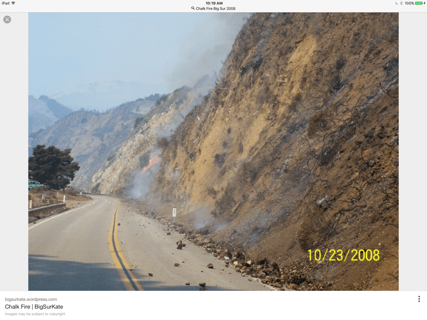
10:30 am – Since this fire first hit the national forest, the plan has been to hold it north of Nacimiento RD. Even today, on the situation report, that is the plan. In 2008, after the Basin Fire was finished, a new fire appeared on the South side of Nacimiento RD. In looking for info about that fire, I was referred back to my own blog … Hmmm…and was shown this photo:
image

9:00 am – Here is a slide show of some photos taken yesterday at Terrace Creek by Cordelia Cluett who lost the home she grew up in up Marble Peak in the 2008 Basin Fire. It provides a different perspective of the back burns yesterday. Thanks, Cordelia

This slideshow requires JavaScript.

From the Post Ranch looking East toward Ventana Inn of the back burn operation yesterday. Photo by Jeffrey Carmichael

image

7:00 am – Big Sur Valley is a bit on edge today, as communities usually are in front of a firing operation. The smoke is drifting down this direction more than it did yesterday, but still not as bad as it looked in town. Busy waiting for report ins from others, and checking on things, but hopefully, those in Big Sur Valley will start sharing their views, thoughts, and experiences after morning coffee.  Until then, sent last night by Michael Minasian of Big Sur Center, taken at 5:50 pm at 27,000′

image
