Soberanes Fire, Day 21, 8/11/16 – Local Reports

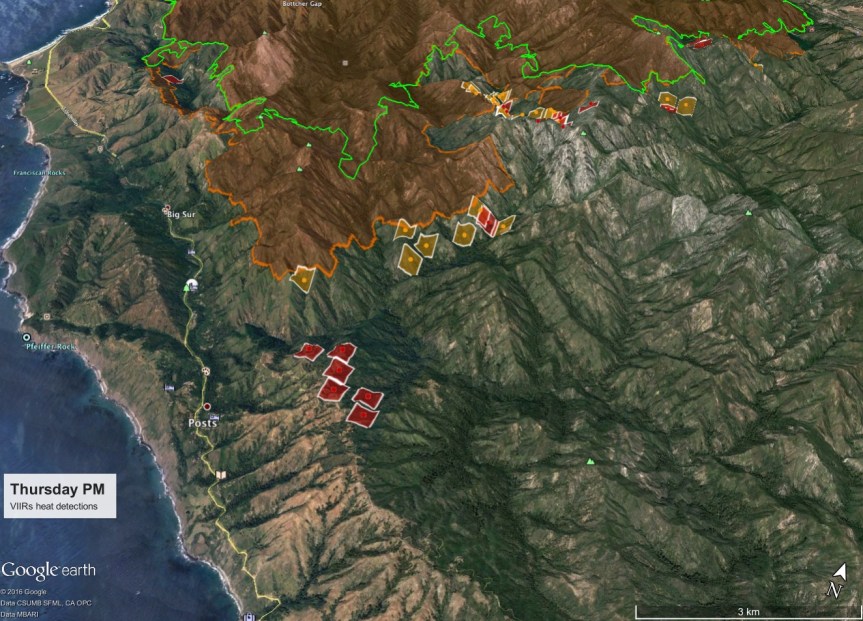
And from John Chesnut a similar one showing the back burn from behind Ventana to behind Deetjen’s. If you zoom in, you can see what looks like a dozer line on the ridge top, all the way down off the map. This may be the one left over from the Basin that is or will be used again.
image

From Keith Vandervere:

Firing operations begin on Coast Ridge. Thursday evening maps & notes https://xasauantoday.com/2016/08/05/soberanes-fire-week-three/

image

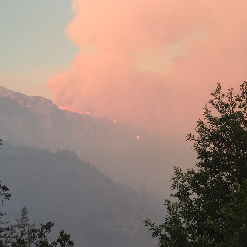
5:30 pm – the view north from my place. I am hoping that this is a backburn mentioned on FB as being back behind Deetjen’s. There appear to be two smoke columns. For orientation, the point sticking out WAY in the back (on the left) is Pt. Sur and  the Lighthouse, which I can see at night

image

From Kyle Evans looking south from Pfeiffer Ridge to Mount Manuel, on the left, with the fire camps below on Monday night – such devastation can also be so beautiful.

image

1:00 pm – From the beauty of the fire (see below) to the ugliness of some of our tourists:

image

Kathleen (Lee) and Byran (Flores) I got a call this morning. I went down to Old Coast Road next to Bixby Bridge and this is what I saw right behind storm drain. It is a hose used to pump an RV septic tank. Can you please notify CalTrans or whoever? I hope someone can get it out of there. Let me know if they can’t and I will do it myself. Also I would like the sheriff and CHP advised about this new approach to sanitation. Ken Ekelund

Here’s one of my favorite photos by Rachel Moody from Applie Pie Ridge, taken Monday Night. In my opinion, it is a classic.

image

10:30 am – Hopkins Ridge activity by Sharen Carey:

image

From BSHC:

NOTICE: BIG SUR HEALTH CENTER PSYCHOLOGICAL DEBRIEFING, Saturday, August 13, 11:00 am.
Dr. Ann Flood will lead a psychological debriefing in order to help prevent post-traumatic stress syndrome related to the Sobranes Fire. The debriefing will begin at 11:00 AM at Big Sur Health Center. Those wishing to have a private meeting with Dr. Flood will be able to meet with her after the debriefing. There is no charge for these services.
During the Basin Complex Fire we had similar counseling services which proved extremely beneficial for many residents. We hope you will take advantage of these complimentary services.
Spanish speaking services will also be available, if needed, provided by Eduardo Eisner.

Also on Friday, the 12th, the Soberanes Fire Fundraiser at the Golden State Theater. I will look for the flyer and post here:

image

And then on Sunday, there is another fundraiser here:

image

************************************************************************

From the Los Padres National Forest of the USFS:

Recreation Facilities that are Open on the Monterey Ranger District

GOLETA, Calif., August 11, 2016…Los Padres National Forest officials today clarified the campgrounds and day use facilities that are open for recreational use on the Monterey Ranger District.
Although much of the Monterey Ranger District is closed because of the Soberanes wildfire, the following sites are open for public use:

· Arroyo Seco Recreation Area
· Kirk Creek Campground
· Mill Creek Day Use Area
· Nacimiento Campground
· Ponderosa Campground
· Sand Dollar Day Use Area
· Plaskett Creek Campgrounds
· Willow Creek Day Use Area

The campgrounds at Arroyo Seco, Kirk Creek, Nacimiento, Ponderosa and Plaskett Creek require a reservation or are sometimes available on a first come, first serve basis. To ensure a camping space, please contact the concessionaire:

Rocky Mountain Recreation – http://rockymountainrec.com or (831) 674-5726 (Arroyo Seco)
Parks Management Company – http://recreation.gov or (805) 434-1996 or (877) 444-6777 (Kirk Creek, Plaskett Creek, Ponderosa, and Nacimiento)
Members of the public are reminded that they should call ahead to the Monterey District Office at (831) 385-5434 for the latest conditions and always consult the National Weather Service for current weather forecasts.

###

Here is this morning’s facts sheet:

imageimage

7:15 am – We have no IR map for the second day in a row, so the perimeter on our maps is out of date. Not much we can do about that, unfortunately. Up here, I can see a thick, heavy marine layer covering all the coast visible to me. It is almost chilly up here, so far today. This is a really good thing for our coastal areas of the fire. Hoping the marine influence will help the last stages of the battle to save Big Sur Valley today, which has thus far been successful. Hoping all can rest a little easier when this day is done.

Soberanes Fire, Day 20, 8/10/16 – Local Reports

7:45 pm – note from Kathleen Lee – the controlled burn from the Molera fire camp was done to control the Italian Thistle so that the trucks that are parking there, are not bringing it out with them to spread it through out the area. Kudos to the State Park Biologists!

7:30 pm – report from a happy local business owner:

“Smile on my face tonight. Marine layer was able to stop the fire in the middle of Juan Higuera basin, the N/F of Juan Higuera is considerable less a threat due to direct attack by Hot Shots from Dell Rosa or Dela Rosa, USFS crew real animals!

The S/F of JH has an area they tried to slow with water until the marine layer returned, they did a backfire to create a safe zone on Hopkin’s and they plan to go direct tomorrow on that area.

By Friday this should be a memory!”

***********************************************************************

7:00 pm – I promised my report from yesterday, so here it is, finally.

We fortified ourselves at the hotel Tuesday with a room service breakfast, packed, and headed out. I need to give a shout out to the Portola Hotel and Spa where we were treated so very well and given a Motel 6 rate for a 4-star room. It was greatly appreciated. We had a dinner that was unbelievable at Jack’s on Sunday night, after the fundraiser, as the crowds were so big and the lines were so long, we couldn’t get the samples of what, I’m sure, were wonderful bites.

So we had the usual town things to take care of, but made it to the River Inn by 11 or so on Tuesday for coffee and Internet, food for Rock Knocker, and local gossip. (Note: if they won’t let me start paying for things, I may have to stop coming!! But then I would miss everyone.) On the way, I stopped at the Little Sur and watched the fire burning on the west side of Pico Blanco, mostly saw smoke, not flames. Also noticed a number of dozers up on the ridge on the north side.

Rather than recount the day, let me summarize the things I took away – first, the tourist traffic was dismally slow and dangerous with lookey loos. The large turnout across from Pfeiffer Ridge was packed with cars, people crossing the road, and a lone officer trying to enforce some semblance of order (mostly ineffectual). Each available turnout in Big Sur was filled with tourists taking photos of the fires. Not a pretty sight. I was astounded at the patience the tourist industry workers were exhibiting with the inane questions and cluelessness. It is a great thing that I ended my tourist industry career about 25 years ago. I don’t have the patience.

We stopped in the parking lot at Ripplewood to watch the 4 helicopters we heard at River Inn come in from the ocean with full buckets, go back behind the short ridge right behind the resort and circle to the top of the Juan Higuera drainage and drop their water … One after the other, after the other, in well practiced precision. I wish we could have seen the actual drops. We later watched the drops on Mt. Manuel and those guys are accuracy in motion. Such pros. I stopped at the TapRoom to use the internet again and recount what I saw, but had nothing to eat or drink, as I was still full. Kurt and I talked the whole time, so was unable to post.

Most of those in the Valley were cautiously optimistic on Tuesday given the hellacious day and night they had had on Monday. I saw my community the way it is during an emergency – the best of the best. I am always so proud to be a member of this wonderful group of human beings, who pick on each other in the best of times, but put it ALL aside and work tirelessly and well together in the worst of times. I can never leave here. It has my heart and my soul – it is the love of my life: the land and the people. Thank you for welcoming me into the fold 31 years ago.

***********************************************************************

4:15 pm – fire in the new fire camp at Andrew Molera? How could this happen? This has got to be a first. Photo by Mike Gilson. One local has it as a “controlled burn” for the fire camp. No “official” confirmation, yet. “At Molera it was a controlled burn from all the poison oak brush they cleared for camp, just didnt bother telling anyone…”

image


Another photo by Mike Gilson, showing Ewoldsen’s (aka The Knoll) on the left taken at some time:

image

3:45 pm – I wish I knew the story behind this one. Just glad the pilot made it safely back to the airport. “Hey Kate….just had a tanker declare an emergency for smoke in the cockpit…..he just landed and shut down on the taxiway…..it is T01….engine crews are at the A/C.”

3:30 pm – from Cal-Fire:

image

Noon – I cannot believe I actually fell asleep again, after such a wonderful night’s sleep, but I did! I received these photos from Ray Martorano, a retired fire captain from FHL who lives near the Paso Airport. He is one of the many, many people who help to keep me up-to-date with information. After 38 years on the FHL Fire Dept. it is in his blood. You can see our fire clearly from there, and here are two of the 5 tankers that are working it from Paso:

imageimageimage

8:00 am – and so the healing begins (photo by Michael Troutman):

image

Mother Nature continues to amaze with her healing powers.

7:45 am – recycling fire signs:

image

7:00 am – ah … What a long sleep I had. It has been almost 3 weeks since I slept 7 hours in one stretch, and this should do wonders for my mental and physical health. I heard from one of those closest to the fire yesterday, and he, too, slept a solid 8 hours. (Exhaustion will eventually win) The marine layer is over those in Big Sur Valley, mitigating fire behavior, for which we are all greatful. Smell of smoke is heavy in the Highlands, so breeze must be pushing the fire back north from whence it came, which has resulted in cleaner air and safer conditions for those of us in the south.

Fire is 68,698 acres with 50% containment. I don’t expect those containment figures to change much over the next few weeks as the Soberanes makes its way deeper into the wilderness.

Soberanes Fire, Day 19, 8/9/16 – Local Reports

9 pm – Sorry, I have to bow out of my promised telling of the day. Must take myself to bed. Here are two photos of the flame and run put the canyon – of the fire on Mt. Manuel’s west side. (IPhone photos, sorry)

imageimage


5:00 pm – I am finally home, completely done in. I will be back to bring photos and observations from my trip to the Big Sur Valley – but know that there are visible flames in places on the west side of peaks from Apple Pie to Mt. Manuel. It is moving slowly downhill with no wind. There are some runs going up canyon with very large flames. If wind were to become a factor, the story would be quite different. Some businesses are closed (Ventana, Fernwood, for example) and others are open (River Inn and The Taproom/Deli, for example.) The new tourist attraction in Big Sur is the fire. The large turn outs in the Valley were filled with with tourists taking photos. The majority of the business seem to center on finding bathrooms. I really am not thinking clearly, as evidenced by taking my “old” camera, for which I did not have spare battery or charger in camera bag, and thus was relegated to using my iPhone. I did take some photos, though. I will bring as much information as I can, after 7 pm, or so. Also note the new announcement about closure again tonight from 10 pm to 6 am tomorrow morning, and finally, of import, is the fact that they are moving the fire camp from the State Park on the west side, to Andrew Molera on the east side. I asked about it, but was told some resources were moving, but unclear as to how much was actually moving, so I went into the State Park and made my own observations. When one sees the food vendors packing up and moving, one knows it must be pretty much the whole camp.

2:45 PM – Reporting from the TapHouse, after watching the helicopters fly over River Inn heading toward Juan Higuera, then watching them dump up…(to be continued)

12:45 pm – helicopters flying the valley, headed north of here – short runs…having a bite, then back on the road to find out what is happening,

11:25 AM – River Inn. Dozer’s replaced on the ridge up above the horseshoe are on a existing dozer line. Local’s asked about a ‘hot spot’ between Apple Pie and the highway. Nothing is visible from the highway, so I think it may have been an anomaly. The MODIS maps for this morning were late, so much was based on last night’s information, local observations, etc.

Highway is not much more crazy than usual, with the tourists, but there is a lot fire traffic, naturally. Andrew Molera Park is a refilling station, and the field to the north is a helicopter landing area. Businesses are open and business is booming.

The feeling in the Valley among the locals I spoke with are that the next 24 hours are critical, and much depends on the fog, temps, and wind conditions. We will all be watching closely.

7:20 am – 67,000+ acres, 50% contained.

6:25 am – I am waiting for breakfast and coffee, then will be getting  ready to leave latter this am for my ride south. A quick look at the maps, and given what I saw from residents re the fire last night, I was surprised to read that the road would open at 6, but per the CHP website, it did. That’s crazy IMHO, but I’ll be able to take photos, if it is not too smoky and post from road. Take a look at these maps provided by Adam Clark and Lucas Ryan in the post below.

[16] ^ROADWAY OPEN
6:08 AM 8 [14] ***PER N115 – ROADWAY IS OPEN ********
4:46 AM 7 [13] 1039 S7 PER A11338
4:46 AM 6 [12] REF LOG MY44 , PER CAL FIRE LAST UPDATE THEY SAY SR1 SHOULD BE RE-OPENED AT 0600 HRS
9:22 PM 5 [9] N115 / CLOSURE IN PLACE
3:49 PM 4 [7] CLOSURE BTWN PALO COLORADO AT MM 61.7 AND VENTANA AT MM 44.9
1:51 PM 3 [6] ANY PUBLIC CALLS/COMPLAINTS REGARDING THE CLOSURE CAN BE REFERRED TO CAL FIRE INFORMATION LINE 831-204-0446
12:36 PM 2 [2] CLOSURE WILL BE MANNED BY CHP OFFICERS, ONLY EMERGENCY VEHICLES WILL BE ALLOWED THROUGH
12:35 PM 1

Those of you in the valley, be safe, please, we need you.

Soberanes Fire, Day 18, 8/8/16 – Local Reports

11:30 pm – from Sharen Carey’s front porch looking toward Apple Pie at 11 pm.

image

10:30 pm from Ed

This slideshow requires JavaScript.

From Emily Montgomery, earlier this evening.

image

8:30 pm first one by Mike, second by Ed

imageimage

From clear ridge by Mike Gilson

image

Mt. Manuel right now by Ed Van Weijen

imageimageimage

Nice slide series of a retardant drop this afternoon on Mt. Manuel by Ed Van Weijen.

This slideshow requires JavaScript.

image

Okay, this a photo from Kurt at the Deli taken at 2 pm. You may have to Zoom in, but you can see that there are at least TWO spots where there is spot fire on the west side of Mt. Manuel – middle right.

image

image

2:15 pm – hi way one to close tonight between 10 pm and 6 am.
Detail Information
1:51 PM 3 [6] ANY PUBLIC CALLS/COMPLAINTS REGARDING THE CLOSURE CAN BE REFERRED TO CAL FIRE INFORMATION LINE 831-204-0446
12:36 PM 2 [2] CLOSURE WILL BE MANNED BY CHP OFFICERS, ONLY EMERGENCY VEHICLES WILL BE ALLOWED THROUGH
12:35 PM 1 [1] SR1 WILL BE CLOSED BETWEEN PALO COLORADO AND NORTH COAST RIDGE ROAD FROM 8/8/16 AT 2200 THROUGH 8/9/16 AT 0600

*******************************************************************

1:45 pm – just finished playing tourist, and see a huge plume out by Cachuagua. I see lots of people have sent me photos. I will post a few. No one seems sure if this is a back burn or part of the main fire – it is burning toward Elephant Mountain, I understand.

From Jim Barr taken at CV Airport at 1:20 pm –

image

These two are from Christopher Bolton and taken from El Caminito. He suggests that perhaps the front plume is near Los Pladres DAm near Danish Camp and the 2nd, back one might be Uncle Sam and Post Summit meeting. I’ve sent these to  Keith to see if he can help id.

Per one reader: See the reference that they are firing off in the Princes Camp area today: http://inciweb.nwcg.gov/incident/4888/


imageimage

1:00 pm – image

9:15 am –

image

8:30 am – view from Post Ranch by Kurt Mayer:

image

7:30 am – Sorry, I was up half the night, worried about conditions in Big Sur Valley, so when I finally got to sleep, it took a Coffee Delivery to wake me up. I am watching closely the maps this am, as several of the lines were breached yesterday afternoon at Post Summit, and lo0ks like it is either over the line at Mt. Manuel or up against it. This day of R&R will be watching closely. Lucas is busy adding a few maps that were just released. Total acres is now 60,459 acres. One structure in Rio del Robles in Carmel Valley burned last night, but residents not injured. Don’t think it was due to the Soberanes Fire, but it was destroyed. I have much to go through to catch up,  then I will load what I can at 8 am.

Soberanes Fire, Day 17, 8/7/16 – Local Reports

9:00 pm – I am trying to catch up with my email, FB, Twitter, etc. after  a day on the road and the fundraiser tonight. (Sorry I couldn’t stay around, it was way too crowded and way to loud for this gal.) I had hoped to meet some of you, but it just wasn’t to be. There is so much to say, and do, and be, but after 17 days, I am tired … As we all are. I don’t hold the title to that, we do. The battle is not over, in fact, in some ways, it has just begun for Big Sur, and I need to get up to fighting speed and strength again. I may not wake at 6 am tomorrow, as I am no longer at home with the early dawn of elevation looking down on me and nudging me toward wakefulness. I am in unfamiliar territory where my exhaustion may win. Rest, but be ever vigilant, as this monster does not want to let go.

Sikorsky @Rancho Grande by Heather Foster:

image

Evacuation of Big Sur clarification:

image.jpeg

2:30 pm – Scott Moffatt has some incredible photos of the progression of the fire starting at 4 am.

Scott Moffatt Photos

1:30 pm – drove through the entire length of Big Sur this morning. It was so smokey, I couldn’t see much of anything. ALL the businesses were closed, from Deetjen’s to River Inn, but the tourists were flocking through. There was little police presence, only at Sycamore’s Hard Closure. Tourists were tearing down the yellow tape all over JPBurns, but I saw no one of authority.

That makes perfect sense … Keep the people out who know the area and know how to be safe, who have lived through numerous wildfires, and let the clueless tourist wander about with abandon.How was this for the local’s safety, again? What am I missing here? In what uninverse is a wildfire safer for the clueless than for the experienced?

12:30 pm – just had lovely lunch at Sur. When I get settled in up here I will tell you my observations driving through Big Sur.

This is Stan Russell and appears to be the “party line” and not what I am hearing or observing. “The evacuation notice issued last night was issued because a 40 MPH wind kicked up and pushed the fire over the dozer line. The slop over fire was a 100 acres. This is the main fire that made the run.

Operations today; they are burning off the dozer lines – back firing. The operation is going well. (Really??)

They will have full air support as soon as they can fly safely. They also have portable fire retardant stations to load up the helicopters.

They weren’t able to back burn the area behind Mount Manuel yesterday.

There will be Public Information Officers posted today at Big Sur Station, Post Office area, Big Sur Bakery, Fernwood Resort, Nepenthe, Ripplewood, and I recommended posting one at the River Inn which he said he would do. They will have sandwich boards with maps and be able to answer your questions.”

At this point the Sheriff’s Department is NOT closing Highway 1, which makes no sense. As one business manager says, “The tourists are allowed in but owners and workers aren’t?”

7:00 am – from Ken Wright who says flames are visible in the north fork of Juan Higuera

image

7:00 am – From Jen Smith on Clear Ridge

image

7:00 am – From Ed Van Weijen on Clear Ridge

image

7:00 am – For all of those asking if Highway One is open — I don’t know, yet, but PLEASE, if you don’t have any business being down here, don’t come. All businesses have been evacuated and are telling employees not to come to work. We don’t need any more gawkers. AND just got word it is expected to close this am at Bixby Bridge.

6:45 – Dawn on Mt Manuel from Pfeiffer Ridge by Kyle Evans

image

6:30 am – by now, all of you have heard of the evacuation order for Big Sur Valley from the Lighthouse to just north of Deetjen’s, both sides. I will be following developments throughout the day, however, I will be heading out the door at 8:30 am into cell phone no-man’s land for a while. When I have reception again, I will check in. This is my day to go north to Monterey for a couple days of R&R. (LOL, as if) but will be online on and off.

Soberanes Fire, Day 16, 8/6/16 – Local Reports

6:30 pm –
The Monterey County Sheriff’s Office is lifting evacuation orders for the area of Garrapata Trout Farm Road and Weston Ridge Road (aka Garrapata Ridge Road). This excludes the driveway north of Trout Farm road.
Palo Colorado Road and the driveway north of Garrapata Trout Farm Road remain under evacuation orders.

image

4:28 pm – Per Kathleen Lee of Dave Potter’s Office (who by the way has been tireless in her assistance during this fire) states she was notified by the IC that they started back burns 10 mins. Ago. YAY

3:30 pm – Post Summit

image

3:21 pm – Just received this photo from Lacie via Ed of the top of Post Summit:

image

3:10 pm – from ED Van Weijen:

image

2:45 pm – this is what it looks like NOW from Clear Ridge, photo by Eduardo Eizner, says it is back of the Little Sur.

image


2:15 pm – Repopulation is taking place in the White Rock area. The evacuation Order has been made a warning for portions of Cachagua and Tassajara. Cachagua Rd. between Nason Rd and Trampa Canyon Rd and Nason Road are still under an Evacuation Order.

2:10 PM – LOST DOG, CHASE, IN THE HIGHLANDS WAS REUNITED WITH ITS OWNER TODAY, DUE TO ALAN, WHO READS THIS BLOG, AND SAW CHASE AND CONTACTED ME AND THEN OWNER.

2:00 pm – There will be a public community meeting at the MAF on Monday, August 8, 2016, at 6:00PM. This will be a briefing to provide an update on the Soberanes Fire progress and containment efforts. If you have questions, this is your opportunity to get answers.

Over the past couple of days, planes and helicopters have been applying retardant on areas around Post Summit and Mt. Manuel in part in preparation for back fires that are planned for this weekend. There will be an increase in smoke today as a result of the back fires used to slow further advancement of the fire. (I am supposed to be notified when they start back burning, and of course, I will notify all of you.)

11:00 am – “Cal fire briefing confirmed. Today two pm Cachagua general store. Intended audience are us still inside road closure and yes will be allowed to return to property. Please trevel with drivers license, and a residential bill like PG E bill that matches your drivers license.” From Jolene

9:30 am – FOUND PARAKEET:

“Have a very pretty parakeet hanging around the house this morning. Have put bird seed out for the bird to eat and fresh water. Not letting us get too close. Currently sitting in a redwood next to the driveway. 667-2182. No idea where he came from out talking to CHP this morning when it flew onto the truck rack!”

And BTW, the lost dog in the Highlands was spotted at 8 am in the highlands and trying to get the spotter and owner together.

9:00 am – Just a reminder that the Local Assistance Center is now underway at Carmel Mission Inn, 3665 Rio Road in Carmel. Will be open until 3. Hope folks will come take advantage of having all these services in one place.

This is for information and services for those displaced/affected by the fire. Many agencies (both state and local) are on hand to help with record replacement, property tax relief, community benefits, insurance issues, permits assistance, home inspections, hazardous waste removal among other issues.

7:30 am – Facts sheet important details. Containment still 40%, acres up to 55,600. There is a burn out operation scheduled for today, but Cal Fire did not indicate where it would be, although I suspect it will be the one behind or between Post Summit and Mt. Manuel to protect Big Sur Valley.

6:00 am – I think I was remiss last night in not posting the facts sheet, or at least the acreage and containment. Acres is 53,900 – now up to 55,682 per IR flight before midnight – but containment is UP to 40%. YAY!! We are watching Big Sur Valley closely, today. Expecting a burn out operation this weekend, hopefully, if conditions are right, today. Another day of waking to no visibility due to smokey conditions. As always, I will be posting information here as soon as it is received, or shortly thereafter.

Soberanes Fire, Day 15, 8/5/16 – Local Reports

If you are going to  the clinic tomorrow, Saturday, with all the various agencies, and you have suffered during this fire, you might want to take advantage of this offer posted in my comments tonight: “Free Stress Reduction Clinic- Ear Acupuncture – Community welcomed – Sat August 6 noon – 4 pm at Community Church of the Monterey Peninsula – ? call Laurie Kleinman M.D .831 320-9560

7:15 pm – the smoke is horrific down here. I cannot see anything at all. I hope this is a burn out. This is bad. No sunset for me tonight.

5:30 pm – photo by Sandra O’Keefe Bellamy from Laureles Grade

image

2:45 pm – planes flying overhead from Paso going north to fire – maybe? Haven’t heard any more or any returns in quite a while (5:30 pm)

2:10 pm – Mt. Manuel by Barbara Sexton from Rancho Rico, who also notes a helicopter just flew over with a bucket. Hmmm…

image

12:30 pm – from Frank Pinney:

“I just got back from the 10:00 Cooperators Meeting at Toro Park, where Martha or I or Cal Fire Bn Chief Mike Martin serve as Agency Representatives for the Brigade daily.

Firing out on the east side of Mt Manuel at tactical points will begin Saturday or Sunday at the latest. Ops is allowing time to get the hand lines needed to help contain and direct the new fire that will be introduced by the hand crews that will reduce the probability that there can be a run uphill to reach the primary fire break uncontrolled.

Firing out is always tricky because they are placing new fire ahead of the main front, so the conditions have to right on target.

Hand line at Gorge highest priority and tie in to the North Coast Ridge Road Firebreak continues to be improved. Frank Zabrowski has tied in with Branch VIII Sur Ops to share historic local knowledge. Still planning to have a community meeting Monday at 6PM at the MAF depending on fire behavior over the weekend (fire ops looking very positive at this time)”

Frank Pinney
Chief Emeritus
BSVFB

12:05 pm – Oh, great. They have expanded the LPNF closure to Nacimiento-Fergusson RD on the south end, thus pushing all the hikers and campers down into our end. Why not close the entire Monterey District??? Now we have to deal with all the illegal campfires with only 1 ranger?? This is idiotic, and if I see Bob Baird on Sunday, I will tell him so,

image

11:30 am – Well, the OES alert system works, and I am signed up, I guess. Two phone calls and 1 email notifying me that the air quality in the Big Sur area, all the way down to the county line is unhealthy, and we are advised to stay indoors with window and doors closed. Okay, I knew that. I also know I can’t close my windows and doors due to temperatures. So there I am. I will get a respite for a couple days soon, though.

10:00 am – Working on widening Hopkins Ridge hand line today, I am told, which is the one down from Mt. Manuel to the Big Sur River gorge Micah mentions below.

9:00 am – from Micah Curtis: “The fire is on Santa Lucia Ridge which runs up from the Little Sur river to Posts summit they were dropping retardant on it yesterday to keep it from blowing up and over Posts Summit and into the valley. They are hoping to to get good conditions to backburn off the dozer, retardant line from the old coast road over Posts summit and mount Manuel they have a hand line from Mount Manuel down into the Big Sur river gorge. The line is unlikely to hold without the backburn, ….”

8:30 am – here is Xasauan Today‘s map: (not looking good for Cachagua or Big Sur Valley, although Cachagua was prepped for a big firing operation last night. The one for Big Sur Valley may have been canceled due to winds.)

image

Today’s update from resident of Post’s Ranch “…the fire is near Apple Pie now. Unfortunately a backfire was never started due to high winds so only retardant and heroic clearance efforts stand between fire and many homes including Melissa’s house right now (about 1 mile). She is packing and moving things up here (Post’s) tomorrow…. We have about a 3 day wait until the fire could be here. I am packing photo albums and made an evacuation list to pack if we get a warning. The air is thick with smoke but it’s ok inside. Planes and helicopters flew over us all day. They sounded wonderful!”

6:00 am – I remember when this used to be an ungodly hour for waking and moving about, never mind writing a cogent sentence. I am confident it will be again, just not confident about when that will happen.

Total acres 53,726

From last night taken by Cache Swanson from Jack Swanson’s Ranch:

image

Soberanes Fire, Day 14, 8/4/16 – Local Reports

8:45 pm – sunset from my observation post and a good night from Bigsurkate and Missy McNab, the mystery dog.

image

8:30 pm – As the fire grows (51.200 acres) so does the containment. (30%). I can’t tell you how impressed I am with this management team. I have been watching them closely for two weeks now, and their planning is the most advanced I have ever witnessed, and I have watched a few. If you witness increased activity in your area, chances are they are preparing a week in advance for the worst case scenario. I watched preparations on Chew’s Ridge via Tom Little Bear Nason for a week, and then watched the hard closures of the roads in the area earlier today, and knew a backfire operation would happen tonight to protect Cachagua. If all goes well (can’t always predict Mother Nature) Cachagua will be breathing easier in just a few days. They have saved White Rock this way, Rancho San Clemente this way, and they will save Cachagua and Big Sur Valley this way. This is a debt that can never be repaid. But here is an organization that provides for the fallen firefighters and their families, and maybe you can help pay your respects and thanks by donating to them:

Wildland Fire Fighters Foundation

6:00 pm – a message from from a friend in Big Sur Valley:

“The fire that was 14 miles is now right next door! Granted it is high on the ridge with a fuel break retardant dropped and dropping still in between. Just thought you would like to know how much fun it is getting to be.”

4:30 pm – for those who can’t go to  the community meeting tonight, and who are familiar with periscope (I am not, so can’t help you there)
“Please join us for the community meeting, live on Periscope at CAL FIRE BEU, or @lospadresnf and @CAL FIRE BEU on Twitter.”

Okay, I did get this link specific to the meeting off of Twitter, hopefully, it will work (caveat, I had to transcribe by hand to paper and then here, lots of room for error with those weird letter/number strings):

Periscope

3:20 – This was taken from the Big Sur Deli at 2:11 by Kurt?

image

1:40 pm – I find myself napping whenever I can. I’ll be back, but in the meantime, a reader sent me this:

image

1:00 pm – Firefighter Brett Gainey captured this insane photo on the Soberanes Fire

image

11:00 am

image

10:30 am – from the Big Sur Health Center:

1) Big Sur Health Center is a non-profit supporting the community during this disaster. BSHC is offering complimentary services to all those who are victims of the Sobranes Fire, whether due to loss of residence, loss of job, or just volunteering to help neighbors fight the fire and protect property. We know from experience that during times of stress, people tend to get sick and/or injured. We don’t want finances to discourage anyone from seeking services.

2) Big Sur Health Center staff is supporting the local firefighting effort by providing on-site evaluation and treatment of the firefighters at the Base Camp at Pfeiffer State Park. We are proud to be able to support these brave men and women.

7:00 am – Another Dawn with no sun, as the smoke is too thick. Breathing has become both a challenge and a goal.

I got many, many shots of the huge plumes yesterday late, that, from what I was told last night, was a successful back firing operation. I couldn’t get them all posted. Will try to do better this am, if you have shots from this morning.

For the first time since the fire started, a predicted change in the weather for the good, allowing for recovery of RH (relative humidity) at night is in the forecast. (See the weather report on the maps post).

From Rancho San Clemente:

image

To see the rest of the photos, go to their FB page.

Soberanes Fire, Day 13, 8/3/16 – Official Reports

This evening’s report

imageimage

This morning’s report

imageimage

Soberanes Fire, Day 13, 8/3/16 – Local Reports

7:30 pm – this is happening right behind Cindra Brimsmead’s house in CV. It is a planned dozer movement.

image

6:15 pm – This does not look good – from my look-out bigsurkate

image

5:30 – from Laurels Grade photo by Sandra O’Keefe Bellamy:

image

5:25 pm – Photo take from Osborne Ridge by Lucas Ryan just now:

image

4:46 pm – the winds have really picked up down here in the last hour … Winds gusting to 13 mph. That has cleared out some of the smoke, but I hope it is not impacting the fire. I am seeing a much larger plume on the west side of the fire, and it is a little bit darker on the east side.

3:04 pm – current plume shot from Laureles Grade by i Sandra O’Keefe Bellamy

11:45 am – for those who are having trouble identifying landmarks, mountains, etc. Here is a great link a reader sent me that I will also add to the links on the right:

Uncle Sam’s Mountain maps

One of the things that is so great about this link is it is specific to Monterey. Before this fire, I had never heard of the mountain, Uncle Sam’s Mountain out there on the east side.

7:00 am – Print this out and take with you to Billy Quon’s “Sur” restaurant in the Barnyard:

image

6:30 am – Extremely smoky down here, can’t really tell what is going on. Lots of burn out operations yesterday in the Cachagua, White Rock, Racho San Clemente area and was posting photos all evening. I’m getting updates, which I will post shortly – I get them in FB PM, email, and easiest (for me) comments in our locals reports post each day. First, let me get this up so you have something to comment on!

A series of photos of the operations and back fire ing at Rancho San Clemente by Bruce Dormody are over on their FB page, with great explanations about the geography.