

Due to life safety concerns from deteriorating conditions on the Nac-Ferg Road and the approaching storm, there will be a hard closure starting 5 pm Wed. 2/15/17
Category: 2016-2017 Winter Storm & Road Reports
URGENT! RE BRIDGE
From MoCo:
Kate,
We are posting this right now, please share.
This is an important message to residents that have been isolated due to the closure of Pfieffer Canyon Bridge. If you need your vehicle for travel outside the affected area, you must move cars to the Pineridge Trails parking lot. State parks has opened the gate there. Time is of the essence. There will be a hard closure of the bridge at 5 PM today. Vehicles are being escorted over the bridge until the hard closure.
From the Big Sur Station:
The Big Sur Station (in coordination with California State Parks & the USFS) has opened the parking lot at the Pine Ridge Trailhead for local residents who are walking across the closed bridge.
We are providing passes during normal operation hours (9 a.m. – 4 p.m.).
The parking pass states:
Parking area only. Pine Ridge Trail is still closed. Leave this pass in your dash (if no pass is displayed you will be ticketed). Make sure to keep the gate closed upon entering and exiting. Do not leave valuables in your car. Thank you.
Questions can be referred to bigsurstation@gmail.com
Thank you!!! What a crazy year!
—
Tim Bills
Coordinator, Big Sur Station
Los Padres Forest Association
Highway Closure


Update: vehicles are allowed to leave the area, one at a time across the bridge until later this afternoon per Cal Trans.
CALTRANS
Highway 1 Update
Sunday, February 12
1:30PM
These photos are of Pfeiffer Cyn Bridge Cyn Bridge (PM 45.5) from yesterday.
***NEW INFORMATION***
State Route 1 continues to be closed between Ragged Pt. (SLO 72.87) and Pfeiffer Cyn Bridge(PM 45.5)
Motorists may travel north on State Route 1 from Cambria to Ragged Point (SLO PM 72.87) or south from Carmel to Pfeiffer Cyn. Bridge (PM 45.5)
The roadway is not passable between Ragged Pt (SLO 72.87)and Dolan Pt (PM 29.70)
*LOCALS/GUESTS MAY TRAVEL BETWEEN DOLAN and SOUTH of PFEIFFER CYN BRIDGE (PM 45.5) AND AVOID CROSSING BRIDGE.
GUESTS/LOCALS MAY PARK NORTH OF PFEIFFER BRIDGE (where available–may require a long walk) AND TRAVEL ON FOOT TO BE ESCORTED BY BUSINESSES TO AND FROM DESTINATIONS SOUTH OF THE BRIDGE.
*BUSINESSES REMAIN OPEN*
Another update will be provided later today, hoped within two hours with information on vehicles exiting.
FOR NOW, ONLY PEDESTRIANS ALLOWED TO SAFELY CROSS PFEIFFER CYN. BRIDGE.
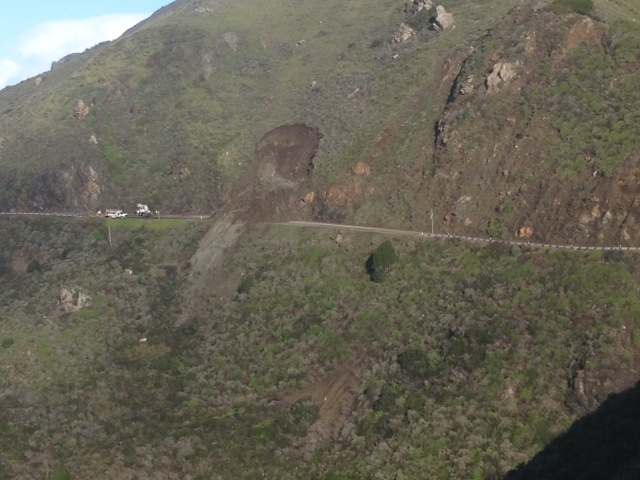
Photo of Slide at Salmon Creek
From Cal Trans:

Hard Closure at Bridge
And now you are stuck one side or the other, and it is closed between you and Nacimiento at both Cow Cliffs and Paul’s Slide
At 6:20 PM Cal Trans says:
Effective immeditely, there is a now a hard closure at Pfeiffer Canyon Bridge at PM 45.5. Nobody is allowed to cross the bridge except for emergency services. CHP is enforcing the closure until noon Sunday, February 12. Crews will be onsite at 9:00 AM to examine the bridge.
Another update will be provided around noontime tomorrow, Sunday, Feb. 12, or sooner if conditions change.
So letting tourists in who had reservations was a great idea, wasn’t it?
Closure on Highway moves north to Pfeiffer Cyn Bridge, MM 45.52
Here is the announcement from Cal Trans with Photos


These three photos are of Pfeiffer Cyn Bridge Cyn Bridge (PM 45.5) from today.
***NEW INFORMATION, IMPORTANT INFO FOR LOCALS **
State Route 1 is now closed between Ragged Pt. (SLO 72.87) and Pfeiffer Cyn Bridge(PM 45.5)
Due to slope movement and slippage, the Bridge column has moved–causing multiple fractures to One of the Two columns on the bridge.
Motorists may travel north on State Route 1 from Cambria to Ragged Point (SLO PM 72.87) or south from Carmel to Pfeiffer Cyn. Bridge (PM 45.5)
The roadway is not passable between Ragged Pt (SLO 72.87)and Dolan Pt (PM 29.70)
*LOCALS MAY TRAVEL BETWEEN DOLAN and SOUTH of PFEIFFER CYN BRIDGE (PM 45.5) AND AVOID CROSSING BRIDGE.
*BUSINESSES REMAIN OPEN*
Thank you for your patience and understanding. Our Maintenance, Geotech and Construction crews continue to work collaboratively and diligently, as much as safely possible in response to these rock/mudslides.
Another update will be provided around noontime
tomorrow, Sunday, Feb. 12, or sooner if conditions change.
Susana Z. Cruz [nature-flower-blue-motif[1]]
Caltrans District 5
Acting Manager
Public Information Office
Per CHP:
3:55 PM 6 [12] 27-D6 CT HAS LOOKED AT BRIDGE / ENGINEERS ADV IT’S COMPROMISED / EVERYONE HAS TO EVACUATE TO THE JNO IT / **THAT’S WHERE NEW CLOSURE IS AT [Shared]
3:54 PM 5 [11] 27-D6 MOVING CLOSURE TO BRIDGE DOING EMERGENCY EVACS OF SR1 DUE TO STRUCTURAL INTEGRITY HAS BEEN COMPROMISED [Shared]
3:25 PM 4 [10] [Notification] [CHP]-ONLY RESIDENTS WILL BE ALLOWED IN , NO LRG VEHS ALLOWED THROUGH (FOOD TRKS, ETC) [Shared]
3:24 PM 3 [8] [Notification] [CHP]-PER HEATH JOHNSTON W/ C/T, MOVING CLOSURE TO MM 45.52 (PFEIFFER CYN BRIDGE) DUE TO ISSUE W/ A BRIDGE COLUMN THEY LOCATED TODAY [Shared]
Paul’s Slide – possible one lane opening?
Brendon just walked through this and sent these photos. You will see it looks as if Cal Trans is hopeful it can reclaim one lane as they are putting in the necessary elements to establish a signal light – generator and propane. Also additional photos of the cribbing coming apart. NIce photos, Brendon Shave. (One photo refused to load for some reason – may have been too large.)


Road Closure, 2/11/17


First two photos are of today’s just north of Salmon Creek (PM 3), the next three are of/around Paul’s Slide (PM 21.6), last pic is of Cow Cliffs (PM 28.35(.Photos provided by Caltrans, two by Ken Harlan and one of Cow Cliffs by Brendon Shave, accordingly.
***NEW INFORMATION***
State Route 1 is now closed between Ragged Pt. (SLO 72.87) and Dolan’s Pt. (PM 29.70)–at 3pm
A new slide just north Salmon Creek (PM 3) ocurred today, requiring to keep the southern closure at Ragged Pt. The slide south of Deetjen’s was stabilized so the Northern closure will move to Dolan Pt (PM 29.70) at 3pm.
Motorists may travel north on State Route 1 from Cambria to Ragged Point (SLO PM 72.87) or south from Carmel to Dolan Pt (PM 29.70) as of 3pm TODAY.
The roadway is not passable between Ragged Pt (SLO 72.87)and Dolan Pt (PM 29.70)
*LOCALS MAY NOT TRAVEL NORTH BETWEEN Ragged Pt and Cow Cliffs (PM 28.35).
*BUSINESSES REMAIN OPEN*
Thank you for your patience and understanding. Our Maintenance, Geotech and Construction crews continue to work collaboratively and diligently, as much as safely possible in response to these rock/mudslides.
Another update will be provided on around mid-morning Monday, Feb. 13, or sooner if conditions change.
And then there is Cow Cliff
North of Paul’s Slide, up by Big Creek is another problem area. Between the two is an island of the Hermitage and Lucia and Morning Glory and a few others where they are completely trapped. In between the two are a number of so far smaller landslides that can’t be cleared until one or the other areas can be cleared. Photos by Brendon Shave, one of the people trapped between the slide at Cow Cliff and the slip out at Paul’s Slide. Oh, and Son … those look like a MC skid marks on the last photo. Yours?


Kiss the Road good-bye until Spring
These were today at Paul’s Slide. Photos by Brendon Shave. I’m not an expert, but I don’t see how anyone can even work on this mess until the rains stop. There are 11-12 photos, and while I could and maybe should put them in a slide show, I sent myself smaller versions:


