One is just south of the Lockwood exit on the 101:
Incident: 00184 Type: Report of Fire Location: Us101 N / Lockwood Loc Desc: NB Lat/Lon: 36.092778 -121.020000
Detail Information
3:19 PM
4
[10] TRANS TO MTRY COM
3:16 PM
3
[5] [Appended, 15:17:21] [1] SMALL VEG FIRE STARTING ON RHS APPROX 1 JSO LOCKWOOD SAN LUCAS
3:16 PM
2
[2] FIRE ENRT
3:16 PM
1
[1] FIRE STARTING ON EAST SIDE OF HWY, JSO LOCKWOOD EXIT
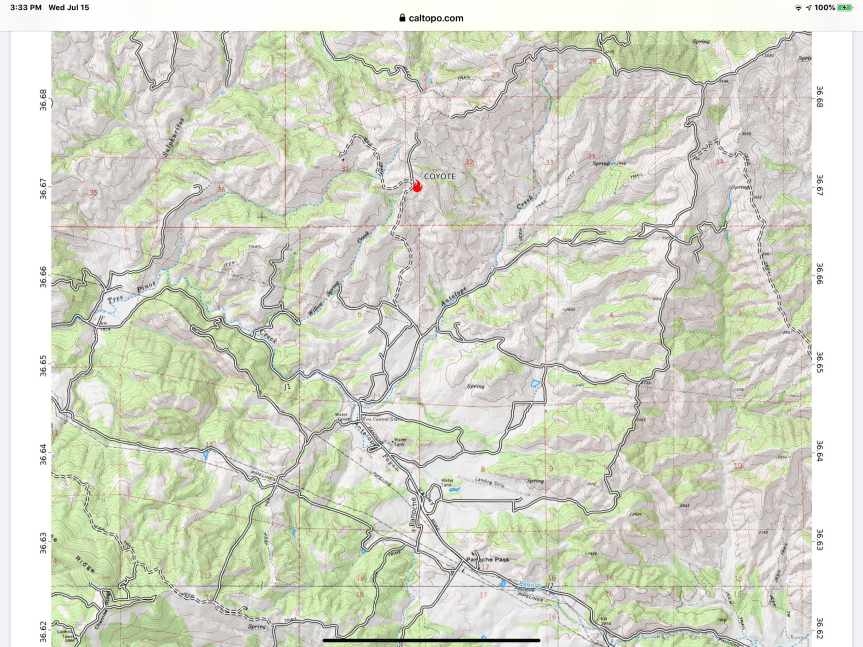
The second is Coyote (near Panoche, I think?), which is much more complex. VLAT 914 is over it per IC “no divert on all air craft due to imminent life threat. SO enroute to assist with evacuations.” Winds and critical ROS towards houses.
Here is a topo of the area. The fire ignition point was where indicated on map. Lots of ranches in the area to evacute.
Coyote Fire, 7/15/20
700 acrs, potential 3000-4000, dangerous rate of spread two dozers enroute, one from MMU, the other from LPF. I am going to start a separate post on this one, as it is quite serious with the winds.
VegetationFire E/O Prunedale, CA (Monterey Co) – BC4612 reports 15 acres, slope & wind driven, potential for 500 acres. AA460, T79 & T80 arriving now. 1000blk San Juan Grade Rd. This is the #BoomerFire. The fire mapping is a new link I have added to my fire links to the right.
Fire is looking much better. Aircraft is being released and diverted to other fires.
How is fire fighting different during a pandemic. I explore that today in my article published in Voices of Monterey Bay about firefighting, the Plaskett fires, and our pandemic. Here are the first few paragraphs. One can go here: https://voicesofmontereybay.org/2020/06/26/wildfire-in-the-time-of-coronavirus/ to read the rest of it.
Photo by Brendon Shave
FEATURED
By Kate Woods Novoa
I’ve been following wildland fires since I moved to the Big Sur backcountry in 1994 and survived my first close encounter in 1996. Big Sur has had a lot of fires since then, and I’ve closely monitored them all. But I had a new fire experience earlier this month that I hope never happens again: two fires in two weeks along the road leading to my house.
The first, on June 3, was called the Plaskett Fire and was caused by humans. The U.S. Forest Service says it is under investigation. The second, the Ridge Fire, started June 17. They were both put out quickly, but before describing how, I want to talk about the science of firefighting first.
I have studied the language of firefighting in my online interactions. Every year, I am immersed in the wildland fire culture in person and online. Fire is why I first learned how to blog and has been an all-consuming summer unpaid occupation for 12 years now, as more and more people use the backcountry, some of whom don’t have a clue about the dangers.
CAL FIRE NEWS RELEASE California Department of Forestry and Fire Protection San Mateo & Santa Cruz Unit CONTACT: Dan Bonfante RELEASE Fire Captain DATE: June 23, 2020 (831) 335-5353 CAL FIRE CZU To Conduct Training Burn FELTON – Crews with CAL FIRE CZU plan to conduct a one-day training burn starting at 9:00am Wednesday. The burn will take place on private property near the Ben Lomond Training Center in Santa Cruz County, west of Boulder Creek. This training burn for new and returning seasonal firefighters will consume 10 acres of grass. This burn will provide the opportunity for firefighters to practice cutting line, making a mobile attack, and firing. The burn is sanctioned by the Monterey Bay Air Resources District. Smoke may be visible throughout parts of Santa Cruz County while the burn is taking place. ###
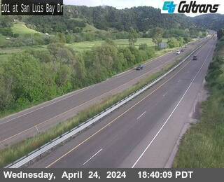
I don’t have a name for this fire yet, nor an acreage estimate, and will add the name to the title and the acreage to the post itself when I do. There is also a fire in Paso Robles, called the River Fire. I will probably have to do a a separate post for the River Fire.
Here is a photo of it taken from the 101:
Report of Fire Location: Exit 263 Us101 N At Paris Valley Rd/san Ardo Loc Desc: EXIT 263 Lat/Lon: 36.069183 -120.987720
Detail Information
2:30 PM
9
[24] [Appended, 14:31:10] [2] TRANS CAL FIRE
2:30 PM
8
[23] [Appended, 14:31:10] [1] ABOUT 2 MI FROM RP’S HOUSE – 65301 DEAD MANS GULCH RD
2:25 PM
7
[17] 1039 CAL FIRE MTRY
2:25 PM
6
[16] CALLER DISC’D ON TRANS TO CAL FIRE MTRY
2:24 PM
5
[14] TRANS CAL FIRE MTRY
2:22 PM
4
[2] TRANS SALINA
2:21 PM
3
[1] FIRE TO THE EAST
2:21 PM
2
[6] [Appended, 14:22:49] [3] SEES FLAMES AND SMOKE
As of 10 am 6/22, Hunter Fire still at 140 acres with 15% containment. (Just for frame of reference, when the Ridge fire was at 30%, it was no longer of any concern to me)
Photo by Rolin Coth, USFS
7:30 PM — spotting on left flank. Two additional tankers being ordered. Now 140 acres burned. Talk of moving resources into the Copperhead area out front of this.
7:00 PM — 140 acres, spotting, starting to take the next “bowl” and still need two tankers that were diverted to Stage, and to Vista, a 3d fire in San Juan Bautista. 0% containment on the Hunter incident.
Fire on Sam Jones Road. FHL unit is making his way into the incident, stating that its on private property and in the SRA. BEU is going to start aircraft as soon as they have coordinates. BEU & FHL resources responding to a working fire, with a structure involved, on Sam Jones Road approximately 1 mile passed the green bridge.
This should be in the area of Bald Mountain, which is the border of FHL and BEU, near the Bryson-Hesperia community.
Full response from both agencies, with a large column visible. Additional ground resources responding from SLU.
Noon update: RidgeFire currently 83 acres & 30% contained. Aerial retardant drops were key in limiting the spread yesterday. Crews are focused today on constructing line & snuffing out hotspots inside the perimeter. #OneLessSpark Photo courtesy Ventana Crew 1.
Photos by Brendon Shave this morning. Still working it.
note the men under the treeAm I glad they are still up here keeping an eye on things.,A whole lot of mop up to doMarcel, our brand-new Patrol 17. Welcome, Marcel!!!
4:56 UPDATE: 300 acres. Spotting among the houses on Spyglass Drive. SBC units on way to fire.
UPDATE: 4:15 PM Fire has jumped the 101 to the East.
Avila Fire started a little over an hour ago. The 101 is being shut down. Pismo PD contacted to start evacuations. Fire heading South. It is at least 25 acres now.


