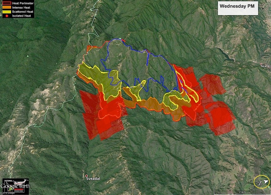
Loma Fire, 9/29/16

John Chesnut Map; note North is rotated.

image

This fire is now expected to be contained by October 3, 2016. Absent any unusual events, I will only be posting John’s maps, if available, on this fire.

Loma Fire Incident Information:
Last Updated: September 29, 2016 6:30 am
Date/Time Started: September 26,2016 2:42 pm
Administrative Unit: CAL FIRE Santa Clara Unit
County: Santa Clara County
Location: off Loma Prieta Rd and Loma Chiquita Rd 10 miles NW of Morgan Hill
Acres Burned – Containment: 3,849 acres – 22% contained
Structures Threatened: 325
Structures Destroyed: 1 single residence and 6 outbuildings destroyed, 1 single residence damaged
Evacuations: Santa Clara County: Mandatory evacuation orders for the Loma Prieta ridgeline area including all tributary roads along Summit Road from Soquel San Jose Road to Ormsby Fire Station. This includes Uvas Canyon County Park, Loma Chiquita, Casa Loma, and Loma Prieta Way. Portions of Croy Road are under an evacuation warning.
Santa Cruz County: All evacuation orders and warnings have been lifted. Evacuation alerts in Santa Clara County can be received by signing up for AlertSCC, visit: http://www.sccgov.org/sites/alertscc/Pages/home.aspx.

Evacuation Centers: Santa Cruz County Fairgrounds, 2601 East Lake Ave, Watsonville (large animals welcome)
Jewish Community Center of Silicon Valley, 14855 Oka Road, Los Gatos
Morgan Hill Presbyterian Church, 16970 De Witt Avenue, Morgan Hill

Road Closures: Loma Chiquita Road, Summit Road from Soquel San Jose Road to Pole Line Road, Mount Bache Road at Highland Road, Casa Loma Road at McKean/Uvas, Mount Madonna at Ormsby Road Mount Madonna Road at Pole Line Road, Croy Road at Uvas Road is open to residents only
Cause: Under investigation

Lost Dog, Palo Colorado

5 month old female registered pure bred Pitt named Plata missing or likely stolen from residence in Polo Colorado. Missing since Saturday the 24th. She is very sweet and could not have a more loving owner. Owner David Vargas’s phone number is on photo.

image

Loma Fire, 9/28/16

Here is the evening John Chesnut Map of the Loma Fire. We got a two-headed monster going, now. Note that North is rotated to be on the right of the map.

image

John Chesnut MAP

image

Here is today’s Topo IR map and the daily update. Today is a town run day for me, so won’t be available much of the day.

image

IR Topo Map in PDF
Last Modified on September 28,2016
LOMA FIRE

Loma Fire Incident Information:
Last Updated: September 28, 2016 6:30 am
Date/Time Started: September 26,2016 3:06 pm
Administrative Unit: CAL FIRE Santa Clara Unit
County: Santa Clara County
Location: off Loma Prieta Rd and Loma Chiquita Rd 10 miles NW of Morgan Hill
Acres Burned – Containment: 2,250 acres – 10% contained
Structures Threatened: 300
Structures Destroyed: 1 single residence and 6 outbuildings destroyed, 1 single residence damaged
Evacuations: Mandatory evacuation orders for the Loma Prieta ridgeline area including all tributary roads along Summit Road from Soquel San Jose Road to Ormsby Fire Station. This includes Uvas Canyon County Park, Loma Chiquita, Casa Loma, Loma Prieta Way, Highland Road and Mount Bache Road. Portions of Croy Road are under an evacuation warning.
Reverse 911 calls have also been sent to residents using Alert SCC. If you have not already signed up for AlertSCC visit http://www.sccgov.org/sites/alertscc/Pages/home.aspx.

Evacuation Centers: Santa Cruz County Fairgrounds, 2601 East Lake Ave, Watsonville (large animals welcome)
Jewish Community Center of Silicon Valley, 14855 Oka Road, Los Gatos
Morgan Hill Presbyterian Church, 16970 De Witt Avenue, Morgan Hill

Road Closures: Loma Chiquita Road, Summit Road from Soquel San Jose Road to Pole Line Road, Mount Bache Road at Highland Road, Casa Loma Road at McKean/Uvas, Mount Madonna at Ormsby Road Mount Madonna Road at Pole Line Road, Croy Road at Uvas Road is open to residents only
Cause: Under investigation
Cooperating Agencies: California Highway Patrol, Santa Clara County Sheriff’s Office, Santa Cruz County Sherriff’s Office, California Department of Corrections and Rehabilitation, San Jose Water Company, Santa Clara Valley Water District, Pacific Gas and Electric and Santa Clara County Office of Emergency Services.

Soberanes Fire, Day 69, 9/28/16

Current Size: 128,595 acres (91,401 acres Los Padres National Forest; 37,194 acres CAL FIRE)
Containment: 89% Personnel: 1,833

John Chesnut Map:

image

I haven’t been able to get the IR Topo map, yet, but here is the Briefing Map, to start …

And now, the IR Topo:

image

IR Topo Map in PDF


image

Briefing Map in PDF

Fire Behavior and Weather Predictions Discussions:

imageimage

Loma Fire, 9/27/16

6:30 pm report (posted at 7, I was busy with the fur kids_

September 27, 2016 6:30 pm
Date/Time Started: September 26,2016 3:06 pm
Administrative Unit: CAL FIRE Santa Clara Unit
County: Santa Clara County
Location: off Loma Prieta Rd and Loma Chiquita Rd 10 miles NW of Morgan Hill
Acres Burned – Containment: 2,250 acres – 10% contained
Structures Threatened: 300
Structures Destroyed: 1 single residence and 6 outbuildings destroyed, 1 single residence damaged
Evacuations: Mandatory evacuation orders for the Loma Prieta ridgeline area including all tributary roads along Summit Road from Soquel San Jose Road to Ormsby Fire Station. This includes Uvas Canyon County Park, Loma Chiquita, Casa Loma, Loma Prieta Way, Highland Road and Mount Bache Road. Portions of Croy Road are under an evacuation warning.
Reverse 911 calls have also been sent to residents using Alert SCC. If you have not already signed up for AlertSCC visit http://www.sccgov.org/sites/alertscc/Pages/home.aspx.

Evacuation Centers: Santa Cruz County Fairgrounds, 2601 East Lake Ave, Watsonville (large animals welcome)
Jewish Community Center of Silicon Valley, 14855 Oka Road, Los Gatos
Morgan Hill Presbyterian Church, 16970 De Witt Avenue, Morgan Hill

8:45 am – estimate is 1500 acres with 5% containment. (Estimate is way too high, Cal Fire reports 1085 acres)  Here is a good link for info:

Cal Fire incident

John Chesnut did up a “bonus” map for us of the Loma Fire, in addition to the Soberanes Fire. Note on this one that North has been rotated in order to provide a regional frame of reference:

image

While I won’t be following this fire as I have the Soberanes, I will put up this new post for others to share information in the comments section. The following photo is by Cal Fire PIO, and is a very sad testament to this fire’s destruction.

image

Soberanes Fire, Day 68, 9/27/16

John Chesnut Map:

image

So now we watch two fires, but first our long-standing one, Soberanes. Here are the maps, interestingly, the IR Topo Map does not include a total acreage, for the first time … And I read that a new team comes in on the 29th, a type 2 team from Arroyo. (Type 2 is less complex than the Type 1 we have had since almost the beginning.)

image

IR Topo Map in PDF

image

Briefing Map in PDF

Fire Behavior (only East Side) and Weather Predictions (Combined):

imageimage


Loma Fire in Santa Cruz Mtns on Santa Clara side


I don’t have it in me to cover another fire, but this one, in Loma Prieta, is very dangerous as there is a lot of WUI threatened. Here, you can see the camera and communications towers are about to be taken out. It is already 200 acres, and Evacs are being ordered. Here is the communication towers – probably the last photo the place will take:

image

One of my readers, Jill Wynn, sent me this one:

image

That is it for me, for now. I am serious, I cannot deal with one more fire. Normally, I would cover fires in the Santa Cruz Mountains, but I just can’t.

Soberanes, Day 67, 9/26 /16

8 pm – meanwhile, back at home (away from the Loma Fire in the Santa Cruz Mtns) This is what Soberanes was doing on Pine Ridge as shot by Michael Troutman from Chew’s Ridge:

image

And here is a happy (and CLEAN) crew from Nevada County sent in by Ana (Alva) Sargenti of East Carmel Valley Road:

imageimageimage

Daily Update:

Current Situation:
A large smoke column visible in many areas on Sunday was from interior burning in the Church Creek drainage. This burning was stimulated by high winds that reached gusts of 51 mph. The fire, while active in that area, did not breach containment lines. Firefighters will be focusing today on the Church Creek area to cut off fire growth.

Outside of the Church Creek area, fire activity on the perimeter was limited to creeping and backing. Fire behavior today is expected to have similar characteristics. Winds are expected to lessen today.

The fire is in transition. Firefighters continue aggressive suppression in areas where there is active burning, primarily on the fire’s east side. But objectives are changing to reflect the work on suppression repair, which addresses adverse environmental effects caused by firefighters and equipment during periods of active firefighting. Three suppression repair groups are now working on the east side. Suppression repair also continues to be a priority on the west side.

Firefighters have completed contingency lines in the southeastern area. In the southwestern area, crews are seeking and extinguishing hot spots and making sure the burned areas are cold.

The Monterey County Sheriff’s Office has lifted the evacuation order for the east side of Tassajara Road from Chews Ridge to Bruce Ranch; Bruce Ranch East along Anastasia Canyon to Carmel Valley Road and South Carmel Road from Anastasia Canyon to Tash Ranch.

Evacuation warnings were lifted from north of Carmel Valley Road from Hastings Preserve to Cahoon Ranch and north of Carmel Valley Road from Cahoon Ranch East to Tash Ranch. All other evacuation orders and warnings remain in effect. Information on evacuations is available at http://tinyurl.com/hcwvsro.

The lifting of the evacuation orders and warnings are the result of progress on the fire. Firefighters continue to complete and improve lines on the spot fires near Chews Ridge and Arroyo Seco.

For more information, visit: http://inciweb.nwcg.gov/incident/4888/ or follow us at http://www.facebook.com/LosPadresNationalForest or http://www.twitter.com/LosPadresNF.
Other contacts: SPCA, (831) 646-5534; American Red Cross, (866) 272-2237.

Today’s AQ Report:

image

John Chesnut’s Map:

image

Maps, yet again …

image

IR Topo in PDF

image

Briefing Map in PDF

Fire behavior and weather prediction discussions: (technical difficulties of some sort seem to be preventing the uploading of these, and of John Chesnut’s map. Will Try later.)


Soberanes Fire, Day 66, 9/25/16

7 pm – a look at the VETS infrared from this afternoon, comparing it to previous, reading what I can find, my confidence level is not as high as it was earlier today. Primarily that is due to the VETS infrared. There is still an active line in Div CC with no dozer line in front of it. Anastasia is still active. The skies have been smokey this afternoon, but by no means as smokey as previous days. I do NOT feel there is imminent threat to either Arroyo Seco or Tassajara tonight, I am just saying it is not over, yet. Here is the map I was looking at:

image

“#SoberanesFire Taped live at the September 24th, 2016 community meeting in Arroyo Seco, Cal 4 Incident Commander Rocky Opliger announces a major change in firefighting tactics. Instead of utilizing strategic firing operations to secure the threatened residences in Arroyo Seco, firefighters will take the opportunity to build direct fire line around the existing fire which is 2 miles north. In addition to being the correct tactic based on current and expected weather and fuels conditions, leaving the vegetation in the watersheds above Arroyo Seco unburnt will result in a significant decrease in erosion. Additionally, strategic firing operations would have resulted in a mandatory evacuation order for numerous residences.”

For those who don’t do FB, here is a link to Vimeo:

New tactics

From Pacific Valley School:

image

Daily Update: September 25, 2016

Current Size: 126,693 acres (89,499 acres Los Padres National Forest; 37,194 acres CAL FIRE)
Containment: 77% Personnel: 2,072 Cause: Illegal campfire Injuries: 1 fatality, 8 injuries

Structures Destroyed:
57 homes, 11 outbuildings
Structures Threatened: 410
Crews: 42
Engines: 97
Helicopters: 22
Dozers: 16
Masticators: 4
Water Tenders: 15

Current Situation:
After evaluating weather and fire conditions, the Soberanes Fire incident management team has made the decision to go direct. Barring unexpected events, there will be no burnouts in the Arroyo Seco area. Recent days of favorable weather, including increases in relative humidity, have created conditions that allow firefighters to engage closer to the fireline.

Direct attack on a fire means constructing a containment line directly on the fire perimeter. The advantages:
· Minimal area is burned; no additional area is intentionally burned
· It is often the safest tactic because firefighters can usually escape into the burned area
· The uncertainties of firing operations can be reduced or eliminated
The disadvantages:
· Firefighters can be hampered by heat, smoke and flames
· Control lines can be long and irregular
· Burning material can easily spread across mid-slope lines
· Can only be initiated when escapes routes and safety zones are available
· More mop-up and patrol is usually required

On Saturday, crews maintained and improved the line around the Chews Ridge spot fire and will continue to do mop-up today. Crews also will continue to mop up the spot fire near Arroyo Seco.
The most active fire area is near Church Ranch, west of Tassajara Road. On Saturday, aircraft worked to cool the area. Firefighters are prepared to protect the Tassajara Zen Center in the event fire reaches that area.

Incident management staff participated in a well-attended public meeting on Saturday at Arroyo Seco.

Evacuation orders and warnings remain in effect in the eastern areas of the fire. Information on evacuations is available at http://inciweb.nwcg.gov/incident/4888 (click on the Announcements tab).

For more information, visit: http://inciweb.nwcg.gov/incident/4888/ or follow us at http://www.facebook.com/LosPadresNationalForest or http://www.twitter.com/LosPadresNF.
Other contacts: SPCA, (831) 646-5534; American Red Cross, (866) 272-2237.

John Chesnut map:

image

6:30 am – Containment is looking good based on today’s IR Map, only lost 65 acres since the last map.

image

IR Topo Map in PDF

image

Briefing Map in PDF

Weather predictions and fire behavior discussions:

imageimageimageimage