Forest Service Temporarily Closes Southern California National Forests,
Adds Prohibitions in Others
VALLEJO, Calif., September 7, 2020 – Most of California remains under the threat of unprecedented and dangerous fire conditions with a combination of extreme heat, significant wind events, dry conditions, and firefighting resources that are stretched to the limit. Due to these conditions, the USDA Forest Service Pacific Southwest Region is announcing the following temporary closures and fire restrictions to provide for public safety and reduce the potential for human caused fire starts. They will go into effect at 5:00 pm Pacific Standard Time on Monday, September 7, 2020, and will be re-evaluated daily as conditions change.
1. Closure of the following National Forests: Stanislaus National Forest, Sierra National Forest, Sequoia National Forest, Inyo National Forest, Los Padres National Forest, Angeles National Forest, San Bernardino National Forest, and Cleveland National Forest.
2. Prohibition of the use of any ignition source on all National Forest System lands (campfires, gas stoves, etc.) throughout California.
3. Closure of all developed campgrounds and day-use sites on National Forests in California.
“The wildfire situation throughout California is dangerous and must be taken seriously. Existing fires are displaying extreme fire behavior, new fire starts are likely, weather conditions are worsening, and we simply do not have enough resources to fully fight and contain every fire,” said Randy Moore, Regional Forester for the USDA Forest Service Pacific Southwest Region. “We are bringing every resource to bear nationally and internationally to fight these fires, but until conditions improve, and we are confident that National Forest visitors can recreate safely, the priority is always to protect the public and our firefighters. With these extreme conditions, these temporary actions will help us do both.”
An example of extreme fire behavior is the Creek Fire on the Sierra National Forest which began on Friday Sep. 4th and grew rapidly on Saturday, Sep. 5th. The fire made a 15-mile run in a single day and burned 36,000 acres, prompting evacuations and life saving measures. The California National Guard evacuated at least 200 people from Wagner Mammoth Pool Campground and assessed them for medical needs.
The Forest Service thanks our partners and the public for their cooperation and understanding of this monumental fire threat. It is critical that all Californians and national forest visitors follow these important closures and restrictions for their own safety and the safety of our firefighters.
The Forest Service manages 18 National Forests in the Pacific Southwest Region, which encompasses over 20 million acres across California, and assists forest landowners in California, Hawaii and the U.S. Affiliated Pacific Islands. National forests supply 50 percent of the water in California and form the watershed of most major aqueducts and more than 2,400 reservoirs throughout the state. For more information, visit www.fs.usda.gov/R5.
And from the other side at Nepenthe by Sander Koning
John Chesnut Evening map:
From MoCo OES:
Effective immediately for the Dolan Fire an evacuation warning is in place for the ZONE 24. Access is permitted only for residents due to fire equipment and emergency personnel in the area. The evacuation warning area for ZONE 24 is as follows: Areas west of Reliz Canyon Road to the intersection of Arroyo Seco Road. South of Arroyo Seco Road to the intersection of Santa Lucia Trail. East of Santa Lucia Trail to the intersection of Bear Mtn. Trail (21S02). North of Bear Mtn Trail (21S02) to the intersection of Reliz Canyon Road.
Here are a couple of photos just taken at 4:25 pm
Firefighters of the #DolanFire plan to begin firing operations this morning on a section of fireline that runs from the near Hermitage to US Highway 1. That means you can expect to see more smoke being produced in that area today. “Burnouts“ as they are called, strengthen the fireline by removing fuel between the line and the advancing wildfire. This creates how much wider a buffer than just a bulldozer line or hand line. Burnouts our carefully planned and executed. This is being done to prevent the Dolan Fire from spreading further south in that area and to protect the structures in that area.
In this video, Operation section chief Reggie Bray talks about fire growth overnight and some of the other activities around the different parts of the fire.
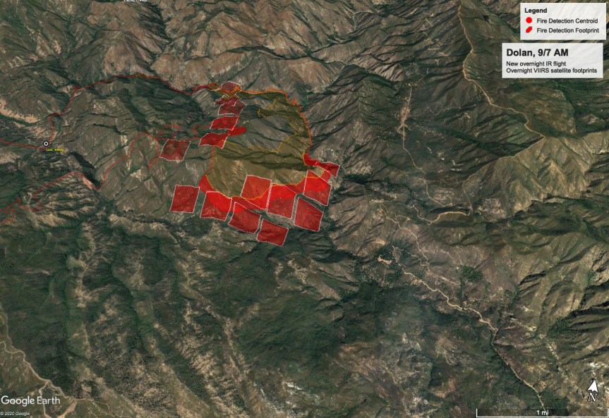
Size: 36,237 acres Containment: 40% Personnel: 883 Start Date: August 18, 2020 Cause: Under Investigation
YESTERDAY’S ACTIVITIES: As expectedfire activity increased on the eastern and southern edges with Cone Peak seeing the most aggressive spread. Record heat and dry conditions continued to play a major role in fire spread. Occasional uphill runs were observed at higher elevations throughout the evening. Structure and asset protection remain priority one for firefighters.
Overnight firefighters monitored HWY 1 for any potential hotspots and rollouts with CalTrans support on cleanup of any fallen debris. Overnight lows were in the high 80’s to lower 90’s with poor relative humidity recovery.
TODAY’S ACTIVITIES: Record breaking temperatures will continue throughout the day and into the evening increasing fire activity. Firefighters along with support from a dozer team continue line construction in the Arroyo Seco drainage and Avila Ranch area reinforcing structure protection. Crews continue improvement of containment lines along McWay Ridge and within the Lucia and Hermitage areas. Several teams are completing the primary containment line north of the Nacimiento-Ferguson Road and along the road to Cone Peak. This indirect line will serve as the primary containment line intended to keep the fire from spreading south toward nearby structures. If conditions allow a planned burnout operation will be used in the next few days to tie containment lines into the fire’s edge. Dozers, hand crews and masticators are also working on additional contingency lines farther south. Helicopters will be available to support ground crews but will be limited due to weather conditions. Structure protection all along HWY 1, in the Partington area north, and in the Lucia and Hermitage areas to the south continues.
Currently in the fire there are: 6 Type 1 Hotshot crews, 10 Type 2 hand crews, 49 engines, 6 dozers, 13 helicopters, 19 water tenders, 4 masticators and a variety of other equipment to support firefighting efforts.
EVACUATIONS: The Monterey County Sherriff’s office has an Evacuation Order in effect for Zone B (Lucia) and Zone J (Prewitt Ridge). Warning are in effect for Zone C (Partington) and Zones K-S (Coast Ridge Road). Yesterday, Zone A was downgraded to a warning. View the interactive map for Monterey County evacuations.
ROAD CLOSURE: HWY 1 is closed from north of Vista Point south to Pacific Valley. Visit https://roads.dot.ca.gov/
WEATHER: Record breaking temperatures continue into the next few days with little relief in sight. Temperatures are in the 90’s along the coast and may reach record breaking degrees again inland. Lower relative humidity across the area are expected throughout the day. Winds are forecast to remain mild.
SAFETY: Firefighters are still actively using HWY 1 as a major access point to the fire. Caution is stressed as emergency vehicles are entering and exiting the highway at all times of the day. Falling rocks and debris continues to be a hazard. Most notably in the area of MP 35 on HWY 1.
And luck would have it, we have a view from the other side, thanks to Scott Healy, Chew’s Ridge Lookout, also from this am;
Let me start off by apologizing for being so late to post. My puppy did a rare thing and let me sleep until 8, so just catching up on where we are today. This is what it looks like this morning:
9/6 8:30 amZoom in on Cone Peak, 9/6/20, 8:30 am
That’s what it looks like from my window this am. Here is the public information map by USFS
This photo was taken by Michael Peckman, a friend of Brandie Kirby Grondin, who is driving this Cal Trans truck. Want to know why Highway One has been closed? Maybe this might help you understand…. (I have permission from both to post this.)
The fire is moving to the south and east within the Ventana Wilderness, growing by several hundred acres yesterday. Moderate fire activity continued in the Cone Peak area. Fire has progressed into the San Antonio Creek drainage and is flanking eastward along the Santa Lucia Range. Fire behavior is expected to increase with the loss of the marine layer, bringing higher temperatures and drier conditions across the fire area.
Hotshot crews continue to build line in the Ventana Wilderness and scout potential containment lines to the south of Lost Valley Trail. Fire fighters are improving containment lines along McWay Ridge and within the Lucia and Hermitage areas. Crews are completing the primary containment line north of the Nacimiento-Ferguson Road and along the road to Cone Peak. This indirect line will serve as the primary containment line, intended to keep the fire from spreading south toward nearby structures. If conditions allow, a planned burnout operation will be used in the next few days to tie containment line into the fire’s edge. Dozers, hand crews and masticators are also working on additional contingency lines farther south. Crews continue to patrol Highway 1 for rolling debris and increased fire behavior. Helicopters will be available to support ground crews throughout the day.
Structure protection all along Highway 1, in the Partington area north, and in the Lucia and Hermitage areas to the south continues. Currently in the fire there are: 6 Type 1 Hotshot crews, 6 Type 2 hand crews, 55 engines, 7 dozers, 12 helicopters, 17 water tenders, 4 masticators and a variety of other equipment to support firefighting efforts.
EVACUATION / CLOSURE ALERTS:
Evacuations / Closures: Click here for an interactive map of Monterey County evacuations. For information about state highway closures go to https://roads.dot.ca.gov/.
Evacuation Order for the area South of Nacimiento-Fergusson Road, west of South Coast Ridge to Prewitt Ridge including Alms Ridge.
Evacuation Warning for Partington Zone C (only residents allowed into the area).
A new Evacuation Warning was issued by the Sheriff’s Office yesterday afternoon for the for the South Coast Ridge Road Zone K.
Highway 1 is closed from north of Vista Point south to Pacific Valley.
WEATHER: A high pressure system is bringing very high temperatures and drier conditions over the fire. Temperatures in the 90’s along the coast and well into the 100’s inland and much lower relative humidities across the area are expected through Monday. Winds are forecast to remain mild.
PUBLIC MEETING: Our next virtual community meeting will be on Saturday August 5th, at 2:00 pm. The meeting will be live-streamed on the Los Padres National Forest Facebook page and can be viewed live or retroactively. If you have specific questions please send them to 2020.Dolan@firenet.gov.
SAFETY: Fire personnel and equipment are staging and working in the Big Sur area. Highway 1 is still closed within the fire area to ensure public safety as well as to allow for safer fire fighting operations. As Labor Day Weekend begins, anticipate increased traffic in areas accessible by the public.
Effective immediately an evacuation WARNING is in place for South Coast Ridge Road Zone K. Access is permitted only for residents due to fire equipment and emergency personnel in the area. The evacuation warning area for Zone K is as follows:
Area bounded by Hwy 1 at about Mile Marker 15, East to intersection of Prewitt Creek Ridge Road and South Coast Ridge Road, South along South Coast Ridge Road to intersection of Los Burros Road and South Coast Ridge Road, west along Los Burros Road to Hwy 1 near Mile Marker 11, to include Plasket Ridge Road, San Martin Top, and Alder Creek Road.
The Evacuation ORDER for Zone J remains in effect.
As a reminder an “Evacuation WARNING” (i.e. sometimes used interchangeably with the term “Advisory”) means those in a specific area/zone should be prepared to evacuate at any time. You do not need to leave your home at this time but please be alert and prepared to leave if an evacuation order is called.
An “Evacuation ORDER” means those in a specific area/zone should leave immediately.
If you feel that your life is in danger, do not wait for an emergency notification.
Additionally: When an Evacuation Order is in place for a zone(s), this means the public, including residents, are not allowed to enter the zone(s). The closures will have Law Enforcement roadblocks on northern and southern closure of Highway 1 turning cars around that are not authorized to be in the closure. This also includes no “In and out” privileges for subjects who decided to stay at their properties despite the Evacuation Order. If you leave the closed area, you will not be allowed to re-enter.
This evacuation warning is also consistent with the new forest closure order:
The marine layer and relative cooler temperatures that have kept fire activity moderate will be lowering and dissipating over the weekend. Although limited fire spread occurred the last several days, the increased heat and drier conditions throughout the fire area forecast for the weekend is expected to increase fire behavior.
The fire continues to move to the south and east within the Ventana Wilderness, increasing by several hundred acres overnight. Hotshot crews are now working in this area, building hand line along the fire’s edge. Crews are also scouting the Lost Valley area to determine the best location to tie into the southern line. Containment lines on the northern and southern perimeters are holding well and fire fighters continue to improve those lines along McWay Ridge and within the Lucia and Hermitage areas. Crews continue to work on the primary containment line north of the Nacimiento-Ferguson Road and along the road to Cone Peak. This indirect line will serve as the primary containment line, intended to keep the fire from spreading south toward nearby structures. If conditions allow, a planned burnout operation will be used to tie this line into the fire’s edge. Dozers, hand crews and masticators are also working on additional contingency lines farther south. Better visibility will allow for additional helicopter support where needed. Crews continue to patrol Highway 1 for rolling debris and increased fire behavior.
Firefighters continue with structure protection all along Highway 1, in the Partington area north, and in the Lucia and Hermitage areas to the south. Currently in the fire there are: 6 Type 1 Hotshot crews, 3 Type 2 hand crews, 62 engines, 6 dozers, 12 helicopters, 18 water tenders, 4 masticators, and a variety of other equipment to support firefighting efforts.
EVACUATION / CLOSURE ALERTS:
Evacuations / Closures: Click here for an interactive map of Monterey County evacuations. For information about state highway closures go to https://roads.dot.ca.gov/.
Evacuation Order for the area South of Nacimiento-Fergusson Road, west of South Coast Ridge to Prewitt Ridge including Alms Ridge.
Evacuation Warning for Partington Zone C (only residents allowed into the area).
Highway 1 is closed from north of Vista Point south to Pacific Valley.
Forest Order Number 05-07-51-20-20 is in effect today, superseding Forest Order Number 05-07-51-20-19.
WEATHER: The marine layer is lowering today to 1,000 feet as a high pressure system moves into the area. The east side and higher elevation areas continue to be warmer and drier. An excessive heat warning has been issued for Saturday through Monday and temperatures are expected to be in the 90’s along the coast and low hundreds inland. Winds are forecast to remain mild. Fire activity is expected to increase with this change in weather conditions.
PUBLIC MEETING: Our next virtual community meeting will be on Saturday at 2:00 pm. The meeting will be live-streamed on the Los Padres National Forest Facebook page and can be viewed live or retroactively. If you have specific questions please send them to 2020.Dolan@firenet.gov.
SAFETY: Fire personnel and equipment are staged and working from the Big Sur area. Highway 1 is still closed within the fire area to ensure public safety as well as to allow for safer fire fighting operations. As Labor Day Weekend commences, anticipate increased traffic in proximity to the fire area.
We are delighted to share the wonderful news that condor chick “Iniko” #1031 is alive and well! Our field crew was given the green light by fire authorities with the US Forest Service to go into the Dolan Fire burn scar area, yesterday, and view the Redwood nest tree of “Kingpin” #167 and “Redwood Queen” #190. Watch Video!
The fire burned just ten feet below the nest cavity, yet “Iniko” survived the fire as observed by Ventana Wildlife Society biologists, Joe Burnett and Darren Gross.
“We were not optimistic as we hiked through the fire’s devastation. To find Iniko alive and well is simply a miracle,” said Burnett.
While we are overjoyed to find “Iniko,” there is now a fifth condor chick #1033 directly impacted by the Dolan Fire.
We are happy to report that yesterday, #1033 was saved from her nest, where she was in a cliff cavity directly in the path of the advancing Dolan fire line.
Chick #1033, age 4 months, has been relying on only her father, “Puff Daddy” #219, as her mother “Wild 1” 231 disappeared last May.
Ventana Wildlife Society biologist Stephanie Herrera safely delivered chick #1033 to her new temporary home at the Los Angeles Zoo where she will spend the next year until ready to be released back into the wild and reunited with its flock.
We are still missing 11 condors, including two chicks and nine adults/sub-adults. The Dolan Fire has burned over 31,000 acres and is currently 40% contained. As the Dolan Fire rages on, help us rebuild the Condor’s Big Sur Sanctuary. Our goal is to raise $500,000 to continue our work restoring this magnificent species.
We will continue to post updates on our homepage as we determine the fate of these missing condors to keep you all informed. Thank you all for your concern, support, and well-wishes.
For more information and updates on the condors during the Dolan Fire, sign up for our eNewsletter.
This will be the last Evening Update for the Dolan Fire unless fire activity changes and additional communication is needed to ensure local communities have the latest fire information.
The Pacific Northwest Incident Management Team 2 assumed command of the Dolan Fire this morning following a successful transition with California Incident Management Team 2. Thank you to Incident Commander Mike Minton and his entire team for their expert management and work to date.
The fire increased by a few hundred acres today along the eastern and southern edges within the Ventana Wilderness. Hand crews are now working in this area and completed line on the northeast side today. Crews are also scouting the Lost Valley area to determine the best location to tie into the southern line. Containment lines on the northern and southern perimeters are holding well along McWay Ridge and within the Lucia and Hermitage areas. Crews continue to work on the primary containment line north of the Naciemento-Ferguson Road and along the road to Cone Peak. This indirect line will serve as the primary containment line, intended to keep the fire from spreading south toward nearby structures. Although limited fire spread has occurred over the last few days, an excessive heat warning is forecast for this weekend and is expected to increase fire behavior. Dozers, hand crews and masticators are also working on additional contingency lines farther south. Overnight crews will continue to patrol Highway 1 for rolling debris and increased fire behavior.
Firefighters continue with structure protection all along Highway 1, in the Partington area north, and in the Lucia and Hermitage areas to the south. Currently on the fire there are: 6 Type 1 Hotshot crews, 3 Type 2 hand crews, 62 engines, 6 dozers, 12 helicopters, 18 water tenders, 4 masticators, and a variety of other equipment to support firefighting efforts.
EVACUATION / CLOSURE ALERTS:
Evacuations / Closures: Click here for an interactive map of Monterey County evacuations. For information about state highway closures go to https://roads.dot.ca.gov/.
Evacuation Order for the area South of Nacimiento-Fergusson Road, west of South Coast Ridge to Prewitt Ridge including Alms Ridge.
Evacuation Warning for Partington Zone C (only residents allowed into the area).
Highway 1 is closed from north of Vista Point south to Pacific Valley.
Forest Order Number 05-07-51-20-20 went into effect today, superseding Forest Order Number 05-07-51-20-19.
WEATHER: Today the marine layer was in place up to 1,500 feet. Fog along the coast burned off earlier in the day resulting in warmer temperatures. The east side and higher elevation areas continue to be warmer and drier. Similar conditions are expected for Friday, with the marine layer lowering to 1,000 feet. An excessive heat warning has been issued for this area from Saturday through Monday and temperatures are expected to be in the 90’s along the coast and low hundreds inland. Winds are forecast to remain mild. Fire activity is expected to increase with this change in weather conditions.
The Pacific Northwest 2 Incident Management Team assumed command of the Dolan Fire this morning following a successful transition with California Incident Management Team 2. Thank you to Incident Commander Mike Minton and his entire team for their expert management and work to date.
The marine inversion layer kept fire activity minimal overnight, active fire in the east and south ends especially around Cone Peak. Although limited fire spread has occurred over the last few days, the excessive heat watch forecast for this weekend is expected to increase fire behavior. Firefighters continue to bolster containment lines in the northern and southern perimeters, mopping up and increasing the line depth along McWay Ridge and within the Lucia and Hermitage areas. Crews continue to work on the primary containment line north of the Naciemento-Ferguson Road and along the road to Cone Peak. This indirect line will serve as the primary containment line to keep the fire from spreading to the south toward nearby structures. Dozers, hand crews and masticators are also working on additional contingency lines farther south. Overnight crews continued improving lines and patrolling Highway 1 for roll outs and increased fire behavior. Crews began building direct line in the eastern edge of the fire within the Ventana Wilderness yesterday.
Firefighters continue with structure protection all along Highway 1, in the Partington area north, and in the Lucia and Hermitage areas to the south. Currently on the fire there are: 5 Type 1 Hotshot crews, 8 Type 2 hand crews, 60 engines, 10 dozers, 10 helicopters, 8 water tenders, 2 masticators, and a variety of other equipment to support firefighting efforts.
EVACUATION / CLOSURE ALERTS:
Evacuations / Closures: Click here for an interactive map of Monterey County evacuations. For information about state highway closures go to https://roads.dot.ca.gov/.
Evacuation Order for the area South of Nacimiento-Fergusson Road, west of South Coast Ridge to Prewitt Ridge including Alms Ridge.
Evacuation Warning for Partington Zone C (only residents allowed into the area).
Highway 1 is closed from north of Vista Point south to Pacific Valley.
Forest Order Number 05-07-51-20-19 remains in effect.
WEATHER: On Thursday the marine layer should remain in place up to 1,500 feet through the early afternoon, with warmer and drier conditions to the east at the higher elevations of the fire. Wednesday, the marine layer was in place, winds remained calm and temperatures moderate over the fire area. Conditions are expected to remain the same through Friday. An excessive heat watch has been issued for this area from Saturday through Monday and temperatures are expected to be in the 90’s along the coast and low hundreds inland. Winds are forecast to remain mild. Fire activity is expected to increase with this change in weather conditions.
SAFETY: This will be a long duration event. Residents in the affected area are encouraged to continue to prepare for the possibility of fire in their area in advance. Go to https://www.ready.gov/wildfires to learn how to prepare.
Dolan Fire
Pacific Northwest Interagency Incident Management Team 2
I am very slow getting going this am, but let’s start with John Chesnut’s maps, and I’ll catch up with the rest after coffee, when the updates start coming in.