

Last Photos of the daylight hours:

And from the other side at Nepenthe by Sander Koning

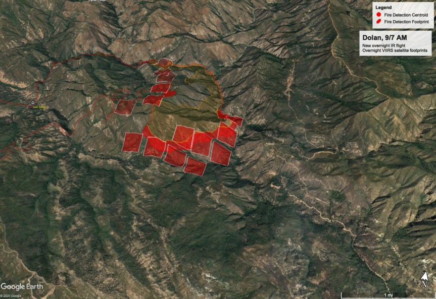
John Chesnut Evening map:

From MoCo OES:
Effective immediately for the Dolan Fire an evacuation warning is in place for the ZONE 24. Access is permitted only for residents due to fire equipment and emergency personnel in the area. The evacuation warning area for ZONE 24 is as follows: Areas west of Reliz Canyon Road to the intersection of Arroyo Seco Road. South of Arroyo Seco Road to the intersection of Santa Lucia Trail. East of Santa Lucia Trail to the intersection of Bear Mtn. Trail (21S02). North of Bear Mtn Trail (21S02) to the intersection of Reliz Canyon Road.
Here are a couple of photos just taken at 4:25 pm


Firefighters of the #DolanFire plan to begin firing operations this morning on a section of fireline that runs from the near Hermitage to US Highway 1. That means you can expect to see more smoke being produced in that area today. “Burnouts“ as they are called, strengthen the fireline by removing fuel between the line and the advancing wildfire. This creates how much wider a buffer than just a bulldozer line or hand line. Burnouts our carefully planned and executed. This is being done to prevent the Dolan Fire from spreading further south in that area and to protect the structures in that area.
In this video, Operation section chief Reggie Bray talks about fire growth overnight and some of the other activities around the different parts of the fire.
For more information visit: https://inciweb.nwcg.gov/incident/7018/
************************************************************************
Monterey County Sheriff’s Office
Monterey County Office of Emergency Services
Information: 831-272-0222 Email: 2020.Dolan@firenet.gov
Media Information: 831-272-0221 Inciweb: https://inciweb.nwcg.gov/incident/7018
Facebook: https://www.facebook.com/lospadresnationalforest
Size: 36,237 acres Containment: 40% Personnel: 883 Start Date: August 18, 2020 Cause: Under Investigation
YESTERDAY’S ACTIVITIES: As expected fire activity increased on the eastern and southern edges with Cone Peak seeing the most aggressive spread. Record heat and dry conditions continued to play a major role in fire spread. Occasional uphill runs were observed at higher elevations throughout the evening. Structure and asset protection remain priority one for firefighters.
Overnight firefighters monitored HWY 1 for any potential hotspots and rollouts with CalTrans support on cleanup of any fallen debris. Overnight lows were in the high 80’s to lower 90’s with poor relative humidity recovery.
TODAY’S ACTIVITIES: Record breaking temperatures will continue throughout the day and into the evening increasing fire activity. Firefighters along with support from a dozer team continue line construction in the Arroyo Seco drainage and Avila Ranch area reinforcing structure protection. Crews continue improvement of containment lines along McWay Ridge and within the Lucia and Hermitage areas. Several teams are completing the primary containment line north of the Nacimiento-Ferguson Road and along the road to Cone Peak. This indirect line will serve as the primary containment line intended to keep the fire from spreading south toward nearby structures. If conditions allow a planned burnout operation will be used in the next few days to tie containment lines into the fire’s edge. Dozers, hand crews and masticators are also working on additional contingency lines farther south. Helicopters will be available to support ground crews but will be limited due to weather conditions. Structure protection all along HWY 1, in the Partington area north, and in the Lucia and Hermitage areas to the south continues.
Currently in the fire there are: 6 Type 1 Hotshot crews, 10 Type 2 hand crews, 49 engines, 6 dozers, 13 helicopters, 19 water tenders, 4 masticators and a variety of other equipment to support firefighting efforts.
EVACUATIONS: The Monterey County Sherriff’s office has an Evacuation Order in effect for Zone B (Lucia) and Zone J (Prewitt Ridge). Warning are in effect for Zone C (Partington) and Zones K-S (Coast Ridge Road). Yesterday, Zone A was downgraded to a warning. View the interactive map for Monterey County evacuations.
ROAD CLOSURE: HWY 1 is closed from north of Vista Point south to Pacific Valley. Visit https://roads.dot.ca.gov/
FOREST CLOSURE: Forest Order Number 05-07-51-20-19 remains in effect on the Forest in the vicinity of the fire.
WEATHER: Record breaking temperatures continue into the next few days with little relief in sight. Temperatures are in the 90’s along the coast and may reach record breaking degrees again inland. Lower relative humidity across the area are expected throughout the day. Winds are forecast to remain mild.
SAFETY: Firefighters are still actively using HWY 1 as a major access point to the fire. Caution is stressed as emergency vehicles are entering and exiting the highway at all times of the day. Falling rocks and debris continues to be a hazard. Most notably in the area of MP 35 on HWY 1.
###
Dolan Fire
Los Padres National Forest
Public Information Phone: 831-272-0222
Media Information Phone: 831-272-0221
Incident E-mail: 2020.Dolan@firenet.gov
Incident Website: inciweb.nwcg.gov/incident/7018

************************************************************************
Here are John Chesnut’s heat maps, and potential contingency line:

Proposed new contingency line on the east side of the fire.

And here is a photo I took late last night; on the south side of Cone Peak to be visible from my place.

Hope the day is not so hot and that the fire slows down. Stay safe. Is John ready to evacuate if needed? I hope he is all right.
Thank you!