48 hour notice on Mud Creek & Paul’s Slide

48-HOUR TRAFFIC ADVISORY**

POTENTIAL TEMPORARY CLOSURE OF HIGHWAY 1 AT MUD CREEK/PAUL’S SLIDE

MONTEREY COUNTY — Caltrans has received notification from National Weather Service (NOAA) data that there is a significant storm arriving in approximately 48-hours for the areas of Mud Creek (PM 8.9) and Paul’s Slide (PM 21.6) on State Route 1 in the Big Sur area.

This advisory is for travelers to be ready in the event the roadway needs to be closed due to a predicted significant storm and allow time for them to prepare for the closure including stocking up on necessary supplies and making plans.

NOTE: At the 24-hour mark, an updated traffic advisory will be sent, either confirming the full closure or providing additional information. These advisories apply only to the Mud Creek and Paul’s Slide areas with each closure being treated separately.


Storm Watch #2, 1/11/19

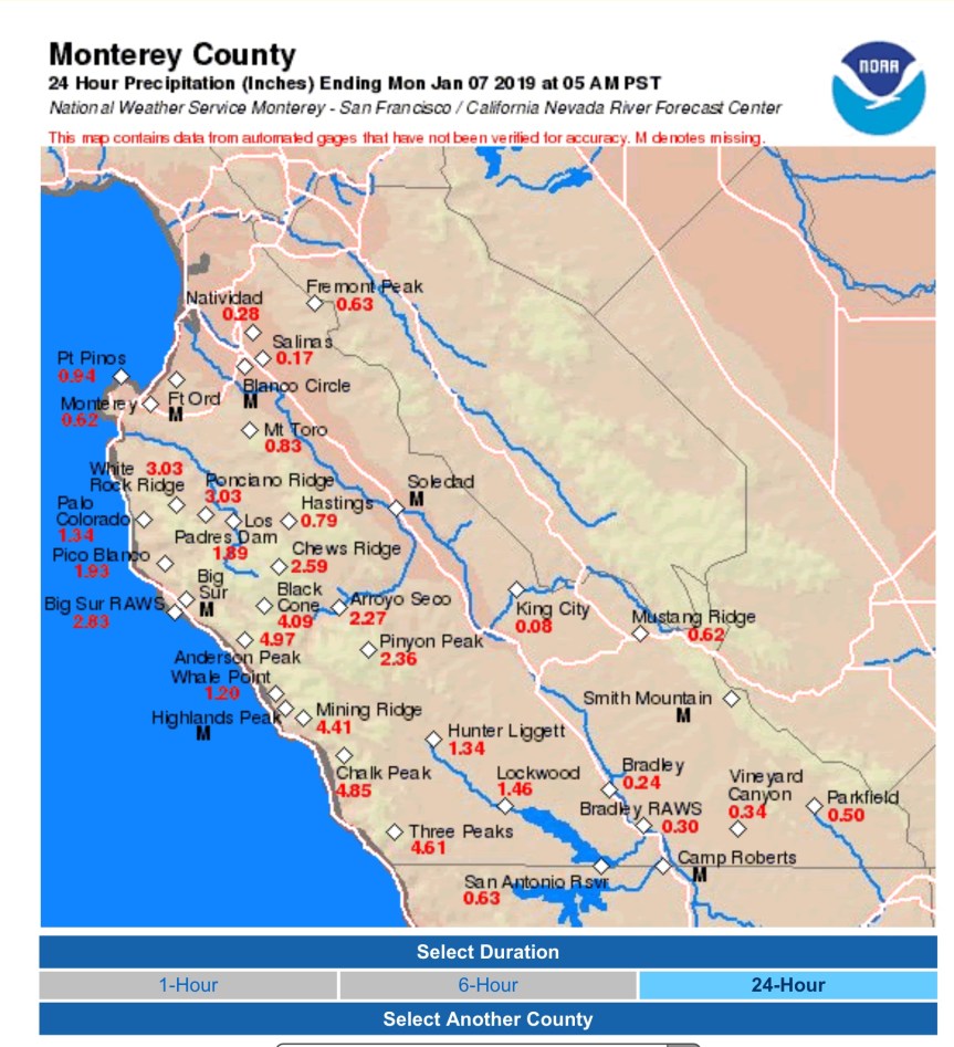
10:30 pm – and it just won’t quit. Day one of ten…Mining Ridge, Chalk Peak, and Three Peaks are the ones you want to keep an eye on relative to Paul’s Slide and Mud Creek.

b1b53d48-cbb9-478b-8279-5b930b1c4b9f

Drops started here 12:21 pm, and it was pouring by 12:39 pm. John Lindsey of SLO just sent out his new predictions, and it is looking pretty grim. Rather than the storms ending by next Friday, they are now extended into the MLK weekend. So, rain pretty much for the next 10 days, with a couple short breaks, like tomorrow afternoon through Sunday morning.

Another cold front brings strong to gale-force (25 to 38 mph) southerly winds and moderate to heavy rain this evening into Saturday morning. Total rainfall amounts with this system are expected to range between 0.75 and 1.75 inches. Snow levels remain generally above 6,000 feet as this system is not expected to bring a cold air mass.

A break in the rain is forecast on Saturday afternoon  into Sunday morning. A 538 dm upper-level trough of low-pressure along the California coastline will direct a series of surface lows and frontal systems into the Central Coast  starting Sunday evening into Thursday. These vigorous surface lows, fronts and troughs will produce a prolonged period of moderate gale-force to fresh gale-force (34 to 46 mph with gust 55 mph) southerly winds along our coastline and heavy rain throughout the Central Coast,  especially along the southerly facing slopes.

Both the ECMWF & GFS model runs have increased cumulative rainfall totals. If these models verify, between 4 and 8 inches of rain is forecast this evening through next Thursday with Big Sur receiving as much as 1 foot of rain over this period. The heaviest rain is expected  on Wednesday. Please see https://twitter.com/pge_john for rainfall graphics.

Unsettled and wet weather is now forecast for much of the Martin Luther King holiday weekend with generally above average daily temperatures. (Here is the graphic he mentions.)

8c7a5cb5-0882-4464-927a-09b52347c071

Storm Watch, 1/11/19

12:21 – the drops began, and now, at 12:39, it is pouring here in Slide Country.

10:00 am – From Daniel Swain of Weather West:

c4d22e4b-29cb-4ac0-9355-dc9f29f5241c

Mud Creek Photos

Before I get to the Mud Creek photos, I ran across these photos of Paul’s Slide taken by Rock Knocker on 11/25/18 and I thought the comparison to the ones Brendon took earlier this week were enlightening.

This slideshow requires JavaScript.

It has been a couple weeks since I showed you what is going on at Mud Creek, so I thought I would bring you up-to-date with photos before we are hit with a week of rain. These were taken by Rock Knocker on Wednesday.

This slideshow requires JavaScript.


Storm Report 1/10/19

Oh, boy…Big Sur to receive up to a FOOT of rain in the next week? So says John Lindsey, SLO Meterologist.

The ECMWF & GFS models increased cumulative rainfall totals.  If these verify, between 3 and 8 inches is forecast Friday through next Thursday with Big Sur receiving as much as 1 foot of rain. The heaviest rain is expected Monday into Wednesday.

15a8fdf0-4ee5-4b71-973a-75bf8ea489a9

And from Dave Hovde of KSBY:

92d6a34d-0d4d-4ea4-90d1-6a3afdd1ee76


Paul’s Slide, 1/9/19

These photos were taken by Brendon Shave last night around dusk of Paul’s Slide on the west side of the highway. He drives the school bus through here 4 times a day M-Th. He believes this happened the day he took these or the day before. On the other side of the k-rail, there is 3 feet of mud or so…or there was last night at dusk. With more rain on the way, I sent these photos to Cal Trans and suggested an engineer take a look at this. I had originally scheduled this for first thing this am, but Cal Trans asked to be able to respond, so I postponed the post until I received their response.

A Cal Trans Geoengineer responded and sent me the first two photos, with the dates noted on them.  The last 6 photos are by Brendon taken at dusk last night.

“I received the photographs taken by a concerned citizen of the scarp adjacent to the road at Paul’s Slide yesterday. Our Maintenance Engineering and Geotechnical personnel have been observing that location for years and documenting it through photographs during the ongoing construction project. See the attached photograph from January 6th showing very similar geometry to the photographs sent yesterday, and a photograph from October 1st showing the same scarp feature before the fill reached the roadway elevation. The scarp and down-dropped material at that location are features of the landslide that constantly move and become more visible when the contractor is not actively working to place fill over them. We do not anticipate an imminent failure there and plan to fill in the dropping area when the site dries out and the contractor can access it. Please keep in mind that Paul’s Slide Complex is an active landslide and continued movement above and below the road are expected. The Department continues to monitor and maintain the area with our Maintenance Personnel and the contractor, including active patrols during the storms this week.”

6d4a166c-8602-4364-9b56-7a8125dbbb3a71236ba9-f8f3-4acb-b34c-0aae2b0d700c

0d898d70-b506-4f15-ba05-e1b60cd4cb344a69dd8f-bb90-4fc4-a567-93c20b27a905598668dd-51b7-473e-8381-880ce3860e8f3d10612f-a2e1-443c-8edd-5cd3fe02c742

5860f807-0990-4cdd-bc94-055cbb0e17c8461c554f-90b2-420c-942b-7302edc39000

Storm Report, 1/8/19

2:30 pm – from a comment below that I think is important to repeat up here:

Sorry, No Tourist Tuesday today. I wrote it last night, with links to the research, but this morning, it was gone. I either …

Hi Folks, so the pattern change i spoke of last month is taking shape, however the storm track pathway is more typical ( may i say “normal” for once!) from a more northerly angle rather than pineapple express storms or atmospheric river storms which have been our pattern the last few years. One major teleconnection enforcing this northerly flow is the Madden Julian Oscillation is rather locked up in the West equatorial Pacific and is not propagating as quick or even at all into the central and eastern Pacific regions but could start shifting in couple weeks. The precipitation composites affiliated with this phase is generally dry for us so its looking more and more likely our wet pattern could stick around for a while. Looking down the road the wet pattern continues thru at least next Tuesday with moderate to weak storms hitting every couple days. Moreover, looking even further out things get real intetesting around Jan 25-28th period when we could see our first real big storm of the likes we havent seen in a while and could be one to seriously prepare for! These smaller storms are priming the land for landslides and river flooding and by the end of the month saturated lands could begin to impact our hills stability and our river bank capacities. Some are calling this Winter “The little Nino that could” and might be fitting term by mid February.

Sorry, No Tourist Tuesday today. I wrote it last night, with links to the research, but this morning, it was gone. I either didn’t save a draft or put it in the queue and now the information it was based on was closed out. So, today will be all about the upcoming storm.

e0620f04-b532-4502-90c6-2699c87e3063

Storm Report & Highway Conditions, 1/7/19

This is part of what NOAA says we can expect:

Long story short, we`ll continue to be under a wet pattern for at
least the next 7-10 days. As the rain accumulates and soils
saturate this week and into the weekend, will have to monitor for
an increasing risk of mudslides and debris flows. Also will need
to monitor for rising small streams and creeks.

8:45 am – Cal Trans is cleaning up between Ragged Point and Salmon Creek and will be cleaning up to Fuller’s and hopes to have the highway open by 10 am. Here are a couple photos from yesterday morning:

5:30 am – It was reported to me by an employee of Pacific Valley School that there was a “hard closure” near Salmon Creek around 11 pm, that several people tried to get through from Gorda and were not able to. I notified Cal Trans this am.

We got an astoundingi almost 5” of rain here in the last 24 hours.

1d616b3d-bb89-4526-84b5-f91baa81dbfb


Highway One is Closed

Subject: Re: Upcoming storm

All,

CHP has requested closing Hwy 1 as of 6 PM tonight due to rocks in the roadway. Big Sur is closing the North end at Fuller’s and Cambria is closing the South end at Ragged Point.

This will be a soft closure like we’ve done in the past and the gates at either slide are not going to be locked at this point. I’ll call Shane and get the CMS’s activated.

Please feel free to respond or call me if you have any questions at all.

Thanks.