7:30 pm – for Jen Croft of the USFS for Air Quality: “As requested, we wanted to share the heads up that these favorable NNE winds will provide a great opportunity for the firing operations to resume along the SE corner tomorrow. Associated smoke should move off towards Tassajara and Big Sur. It might get a little smokey in the evening as the cooler temps settle smoke in the drainages, but these efforts are one step closer to the successful containment.”
Photo by the USFS:
Reminder – there is a community meeting at the Fire House in Arroyo Seco tomorrow, Sat the 24th at 6 pm.
On a personal note, I am leaving later this am for lunch in Big Sur Valley, which means I will be in and out of cell phone range (and thus Internet) until late afternoon. Looks like a gorgeous day for a drive here on the west side of the fire.
7:30 am – John Chesnut’s map:
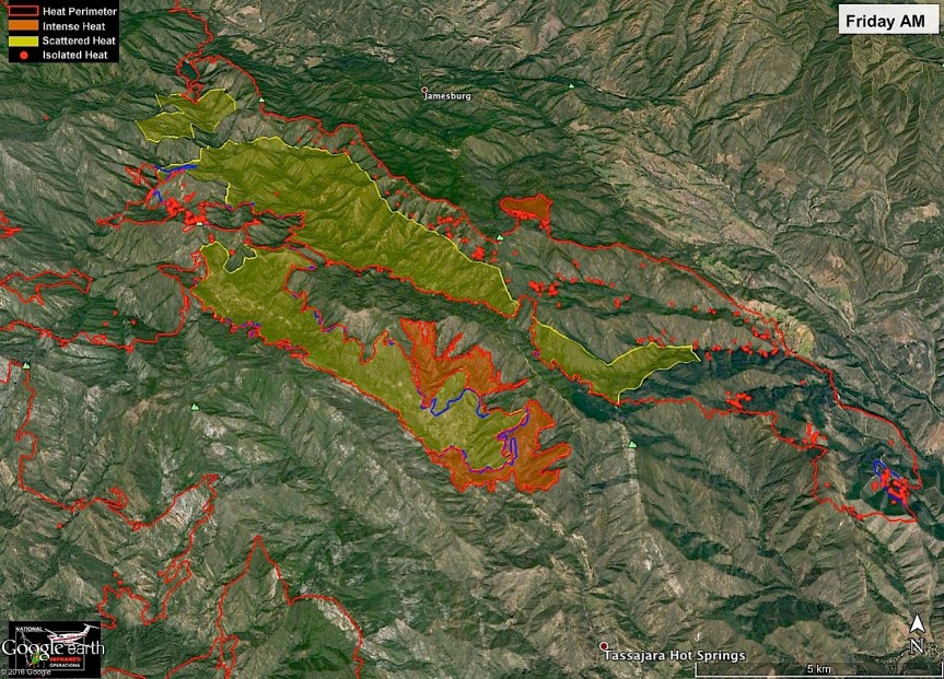
7 am – we lost a little over 1,000 acres since the last IR map. Here is today’s;
7:15 pm – “These are the Zuni Firefighters from New Mexico..they are going around to each resident on East Carmel Valley Road several miles up from the Arroyo Seco Rd. intersection, to make sure there is enough defensible perimeters around structures to be protected in case the fire comes in..amazing how considerate they all are..Clybert is standing by the car…bless them for all their personal safety concerns and hard work..we all have evacuation warnings here..
Alva Ana Sargenti…East Carmel Valley Road…”
John Chesnut’s pm map:
Looks to have been more quiet than expected. Always welcome.
Great short video describing what happened last night and what is expected today here:
And for those of you who want to see the proper, ano very detailed group of weather forecasts for both sides of the fire go here: (too many for me to upload)
The fire is moving closer to Tassajara. There is large potential for a wind event beginning this afternoon into tomorrow morning, with gusts up to 30 to 40 mph from the NW. This is significant not only because of the high winds but also because of the direction, which topographically lines up with the Church Creek watershed to Tassajara. Many pairs of eyes are watching for this weather event.
Today (9/22), the ZMC Fire Brigade is preparing for the possibility of the Tassajara firing operation starting at around 12 PM. Depending on conditions however, it may start today, tomorrow, or the next day.
Also, remember the Monks have the Alpine Hotshot Crew with them to help this time.
10:00 am – Here is John Chesnut’s map for this am, as well as the usual update by the USFS:
Daily Update: September 22, 2016 (this is the “Press Release”) – personally, the information found on inciweb is a bit more thorough, including weather predictions.
High winds with gusts as high as 35-40 mph are expected to continue through today. A dry cold front will create challenges in all areas of the Soberanes Fire, particularly along drainages that align with wind direction. Steep terrain and drought-stricken fuels increase the likelihood of difficult control efforts.
High winds overnight were counteracted by higher than expected relative humidity, limiting fire spread. Continued high winds are likely to increase intensity along the fire edges. The winds also will test the containment lines and could cause increased activity in seemingly dormant areas of the incident.
Firefighting efforts on Wednesday were focused on two spot fires burning outside primary containment lines. The spot fires were the result of wind-blown embers from within the containment lines. Neither spot fire expanded on Wednesday. Aggressive mop-up operations will continue today.
Line-building burnout operations, which were highly successful in recent days are largely on hold until weather conditions are more favorable. In the face of difficult conditions, efforts today will be to successfully hold established fire lines. In all cases and at all times, safety of firefighters and the public are paramount.
Evacuation orders and warnings remain in effect in the eastern areas of the fire. Information on evacuations is available at http://inciweb.nwcg.gov/incident/4888 (click on the Announcements tab).
Air monitoring is being conducted throughout the incident. Communities affected by drift smoke include Tassajara,Carmel Valley, Cachagua, and Arroyo Seco..
A community meeting is scheduled for 6 p.m. on Saturday, Sept. 24, at the fire station in Arroyo Seco, 46700 Arroyo Seco Road.
9 pm – flare up reported on Mt. Manuel, and no power in Big Sur Valley. Damn … I am so tired of this. I can’t get any IR info right now for the Big Sur Valley, but this afternoon shows a couple flare ups on the interior sections of the west side of the fire.(see 004 and 005 below.)
The VIIRS overpass (time stamp 2:15 PM) has been posted. Active heat in Pine Valley, and one spot down in the extreme SE corner. No heat detection in the Anastasia/Bear Trap slop-over
The Hastings weather station shows steady 13 NW wind, with gusts to 19 at 2 PM. Wind is building steadily. Map by John Chesnut.
This is the morning VETS map, finally posted on line, this shows the Chew’s Ridge detail.
From Cachagua about 1 pm by unknown photographer from Instagram:
1:43 pm – right now from Laureles Grade looking toward Carmel Valley Village by Sandy O’Keefe Bellany:
Today’s status report (current situation only):
” A Red Flag Warning takes effect this afternoon and is expected to remain in effect through Thursday. Potential gusting winds of 25-35 mph have prompted the warning. Large fire runs and increased activity on ridge tops and west-northwest aligned drainages are possible. There is a concern that hot spots could intensify and threaten established east-side containment lines. Wind-driven embers from hot spots could ignite spot fires as far away as 0.75 miles [Ed note – In today’s fire behavior discussion it puts spotting at 1 mile OR MORE for Thursday – so a good example of one set of information for firefighters, and another for the public]. Firefighters will be staged and prepared to deal with that contingency.
A Red Flag Warning indicates the onset of critical weather and fuel moisture conditions that could lead to rapid or dramatic increases in wildfire activity. Factors may include low relative humidity, strong winds, and dry fuels.
Firefighters on Tuesday and early today successfully limited progress of hot spots burning outside the primary containment line north of Chews Ridge and near Arroyo Seco.
Both of those spots continue to burn but neither is advancing. Both are within secondary containment lines. [Ed. note – up until this report, PIOs have insisted, to me, anyway that they were within containment lines – no discussion of primary and secondary, despite questioning. This change is a welcome step toward better communication.] Evacuation orders and warnings remain in effect as a result of the Chews Ridge spot fire. Information on all Soberanes Fire evacuation orders and warnings is available at http://inciweb.nwcg.gov/incident/4888.
The burnout operations of the past week, which have been highly successful in establishing and strengthening the containment lines, will be limited because of the changing weather conditions.
A community meeting is scheduled for 6 p.m. on Saturday, Sept. 24, at the fire station in Arroyo Seco. A well-attended community meeting was held in Arroyo Seco on Tuesday.”
From inciwebs report today, a few statements of interest (in no particular order):
1) “Current uncontained fire perimeter is 75 miles with a total planned 191.1 miles to reach containment objectives.”
2)”Coordination with the Pacific Southwest Regional Office and Los Padres National Forest is underway for additional use of mechanized equipment within a small portion the Ventana Wilderness. This operation will enhance firefighter safety, and minimize risk to life and property within the area.”
3) “12 Hours: The Red Flag Warning issued for the area has the potential to aid in large fire runs and increase fire activity on the ridge tops and WNW aligned drainages. Hot spots near the line will have an increased probability of threatening containment lines.”
“Very few hot spots detected in the overnight VIIRS pass (shown with fire icon). That is very good news for the day.
The pix you uploaded yesterday showed a smoker from Carmel Valley Road being worked by helicopters with retardant — this is the area highlighted with arrow in bottom right corner of image. The smoker is outside the primary containment line, but as your pix showed has retardant lines all around it.
Note there is a tiny hot spot right at the buildings at Church Creek/Caves — this might be a patrol or backfire around the buildings.
Got my fingers crossed that with another good day the FF will be ready for a windstorm.”
And here are the weather predictions and fire behavior discussions for both the east and west sides of the fire. Due to winds, low humidity, and possible slope alignment spotting up to a mile or more is possible. Head on a swivel this wind event still predicted to begin at 3 this afternoon and go until 9 pm Thursday.
Afternoon from John Chesnut. If you are reading this, John, your maps are absolutely invaluable to me and others. Thank you.
**From US NationalWeather Service San Francisco Bay Area/Monterey California**
RED FLAG WARNING FOR the Soberanes Fire area from 3:00 pm Wednesday, September 21 through 9:00 pm Thursday for strong NW winds.
9:50 am – new statement from the USFS: “Unfavorable weather conditions and strong NSW winds, carried embers across the control line near Chews Ridge and into heavy fuels. This wind event produced a spot fire on the east side of the dozer/containment line resulting in a new evacuation order. In addition, two evacuation warnings were issued.”
On the Evacs, they had this to say: “A new evacuation order was issued for the east side of Tassajara Road from Chews Ridge to Bruce Ranch. Bruce Ranch east along Anastasia Canyon to Carmel Valley Road. Carmel Valley Road south from Anastasia Canyon to Tash Ranch.
New Evacuation Warnings were issued from:
North of Carmel Valley Road from Hastings Preserve, from Cahoon Ranch east to Tash Ranch.
The Evacuation Order for Tassajara Road south of Chews Ridge remains in effect.
The Evacuation warning for the east side of the fire near Arroyo Seco, southwest of East Carmel Valley Road starting at the intersection of East Carmel Valley Road and Piney Creek Road, extending east to the Arroyo Seco Road remains in effect. As well as the warning for the Arroyo Seco Road from East Carmel Valley Road extending west past the Arroyo Seco Campground.”
8:30 am – There is a fire hotline I would encourage you to call to express your concerns, frustrations, and to ask questions. I will be in and out today with the life of country living (frig went out, hose nossels broke, you know the routine). That number is: 831-204-0446. Share your observations in the comment sections and I will check in to my email for any photos sent – I will create a new post for those immediately.
Here is John Chesnut’s Map for this morning:
Before the maps, last night-early this am, MCSO issued an evacuation order: “The Monterey County Sheriff’s Office is ordering an evacuation for the east side of Tassajara rd from Chews Ridge to Bruce Ranch, east along Anastasia Cyn to CVR and south to Tash Ranch. Any questions call 831/204-0446.” There is also an evacuation warning for an area of Carmel Valley Road. “Evacuation warning has been issued for north of Carmel Valley Rd. from Hastings Reserve to the Cahoon Ranch.” From someone who got a reverse 911 last night/early am.
Here is the evacuation map. Yellow is evacuation order and light blue is evacuation warning:
11 pm – in the last hour I received two reports from Chew’s Ridge, Jessie wrote me re lots going on out there, After that, Tom Little Bear Nason posted this to his FB page: “The Fire jumped the Dozer lines over at Cahoon Ranch and is headed up Anastasia Canyon right up towards Tassajara RD and our Ranch and its raging out of control right now🔥⚠️🔥
It’s Burning fast and hit with winds up 40 mph!!!” Prayers for all.
From a comment on my FB page: “I just called the Cal fire hotline/ and they said “it did jump tassajara in one place up there and there’s a “small” (?) spotfire that they are monitoring -and sending in more resources. they ARE going to do a mandatory EVAC- but it will be up the road farther. chews Ridge to Bruce ranch-and a couple other ranches that I am not familiar with-(tosh ranch?) he didn’t seem to think that lion Springs would be evacuated and certainly not down at Jamesburg or me… at least not tonight anyway. 😁
and- that they will be doing a reverse 911 for the affected areas within the hour.”
Here are three maps Luke did up for me when I sent out a desperate cry for help (I used to be able to do these, a few fires ago, but lost that knowledge somewhere) which he most promptly offered. We don’t have the landmarks on it due to lack of time, but those in the area will recognize anything of concern to them.
7:30 pm – just spoke to a PIO at operations about some concerns I have. Strike Team from Santa Cruz and Santa Clara was toned out around 5:30 pm and there are some MODIS spots outside containment lines – but remember, MODIS is notorious for picking up heat in the columns, so we will have to wait on this for confirmation. He had not heard from operations, so was unaware of any problems out in the field. Seems communication with their own PIOs cannot be updated on conditions as fast as we would like. He will be recommending another community meeting for the Cachagua/Carmel Valley folks, but in the mean time, he encourages all of you to call the information line anytime with any concerns you have.
12:45 pm – Huge plume visible from the Eastern side of the fire. Must be more firing off operations.
Here is the VETS IR flight from this morning: (BTW, VETS is an acronym for a private company that does day-time Helicopter IR flights – usually two a day.)
From John Chesnut:
10:30 am – from the USFS:
Incident: The Soberanes Fire is burning in the Los Padres National Forest, Ventana Wilderness, in Monterey County, CA. The fire was started by an illegal campfire on July 22, 2016, in Garrapata State Park.
Agency Jurisdiction: CAL FIRE San Benito-Monterey Unit/Los Padres National Forest.
Incident Command: California Incident Management Team 4, Rocky Opliger, Incident Commander.
Current Size: 117,656 acres (80,462 acres CA-LPF; 37,194 acres CAL FIRE)
Firefighters have made strong progress on the Soberanes Fire, as evidenced by the increase in the containment level to 67%. That is an increase of 15 percent since September 13. The increase is largely due to weather conditions that contributed to favorable burnout* operations. Activity is predominantly in the south-southeast areas of the Soberanes Fire. The burnouts are key to the firefighters’ success over the past days in widening and strengthening the indirect* containment line.
The fire continues to burn in remote, rugged terrain, including in the Ventana Wilderness. Firefighter and public safety remain the priority in every situation.
Heavy smoke in the area on Sunday was the result of an atmospheric inversion that held smoke from the burnouts in the valleys. Area residents will continue to see smoke columns and atmospheric smoke today.
Winds in the region changed today, with flows now from the south and southwest. The change may mean more erratic winds affecting the fire and pushing smoke toward the east side of the fire. Continual monitoring of weather and evaluation of forecasts will be used to determine when conditions allow for burnouts.
*Burnout is intentionally burning vegetation from the indirect fire line.
**Indirect line: a fire line constructed away from the hot edge of the fire.
###
Forest Service Shield
Jennifer Gray
Visitor Information Assistant
Forest Service
Los Padres National Forest
p: 805-961-5795
f: 805-961-5729
jsgray@fs.fed.us
6750 Navigator Way, Ste 150
Goleta, CA 93117 http://www.fs.usda.gov/lpnf
Twitterhttp://wwwstatic.fs.usda.gov/images/facebook.png
Caring for the land and serving people
Here is John Chesnut’s map:
4:30 am – Day 60. *Sigh* Today we tied the previous record for the longest running fire in the Los Padres National Forest held by the 2007 Zaca Fire in Santa Barbara County…a dubious distinction, at best. Almost 4,400 additional acres were scorched yesterday, bringing the total to 117,656. Here are the maps:
3:00 pm – Rana Creek Staging Area this am by Howard Jones
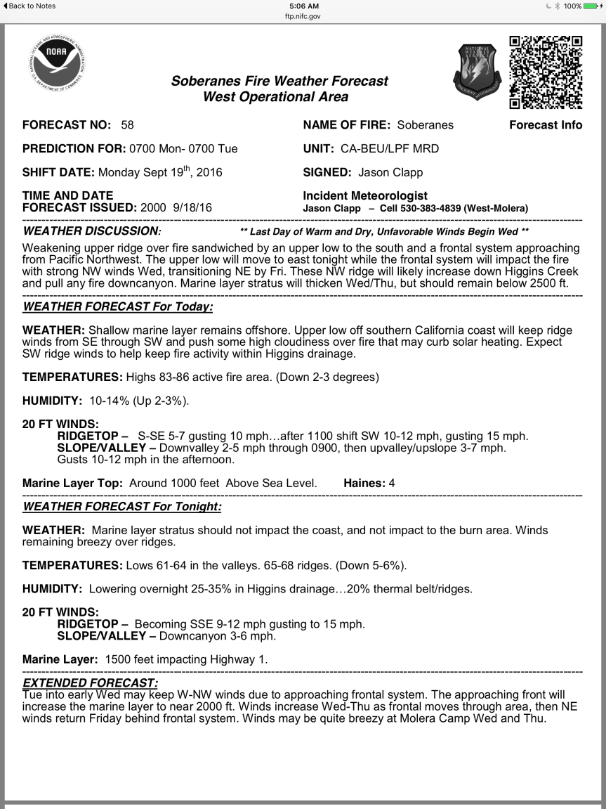
11:30 am – I’ve never paid quite such close attention to the winds forecasts as I have been the last two months. Here is John Lindsey of SLOs predictions: “Moderate to fresh (13 to 24 mph) northwesterly winds will develop along the coastline this afternoon, decreasing tonight. Gentle to moderate (8 to 18 mph) west to southwesterly winds are forecast on Monday into Tuesday. Fresh to strong (19 to 31 mph) northwesterly winds are forecast on Wednesday, increasing to strong to gale-force (25 to 38 mph) levels Thursday into Friday, decreasing over the weekend.”
So, for me, that explains the extensive back burn while winds were favorable, because very soon, they could have really threatened Cachagua, Jamesburg, and Carmel Valley.
10:05 am – from the USFS:
**Update Soberanes Fire**
Current Size: 113,259
Containment: 61%
Personnel: 1,921
Burn out operations were successful on Saturday on the eastern edge of the Soberanes Fire. Burning occurred in the area of Chews Ridge north towards Los Padres Dam. They strategically put fire on the indirect line to prepare the area for any future fire activity. Smoke will be heavy in all areas near Carmel Valley, because of the wind directions.
Evacuation orders have been lifted for Coast Ridge Road from 1.5 miles to the Ventana Inn to the end of Coast Ridge Road at Marble Park, and roads that leave from Coast Ridge Road. Also for Big Sur South Coast Center area and Big Sur Partington Ridge area. All other evacuations orders and warnings remain in effect.
As the fire continues, operations names the number one priority as the safety of our firefighters and public.
Photos are from yesterday taken by, Hugo Patino – Public Information Officer
10:00 am – from John Chesnut: “The Sunday AM (3:50 AM) VIIRS overflight has been posted. Shows some further expansion west and south.
The fire front along the burnout is 12 miles long. Will be interesting to watch how quickly it climbs the shaded north slopes in Miller Canyon.”
8:00 am – here is John Chesnut’s google map of the burn out area:
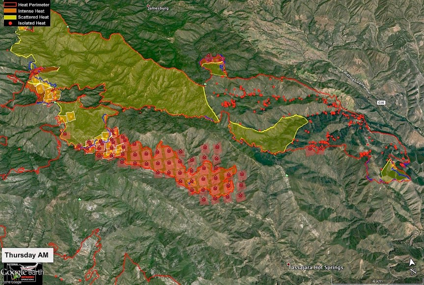
6:45 am – Here is today’s IR flight map. It was taken at 8 pm last night, and shows an increase of almost 5,000 … Most, if not all, of it on the east side from the ambitious burnout operation undertaken this week. I will add the rest of the maps after I’ve taken care of the doggies.
Now, I’d like to zoom in on Div SS, as a new “fire line” has been drawn between Rodeo Flats and DP-110. What does a “fire line” mean? Take a look at the topography. I might be missing something, but there doesn’t appear to be any dozer line or hand line, or any way of putting in either one. How can one stop or start a fire line here? I think I will be making a phone call later this am to see if I can get an explanation.
There will be a community meeting on Monday, September 19th at the Big Sur Station (MAF) at 6:00PM. The meeting will present updated information on the Soberanes Fire from the new California Incident Management Team 4, the USFS and the Big Sur Volunteer Fire Brigade and will answer any questions you may have.
I think this is the longest post with the most maps, information, and photos that I have published thus far, but that’s it for tonight. Time to put this (and me) to bed. Good night, Gracie.
From 8:30 pm a new satellite pass MODIS map. This one provided by John Chesnut, again:
From Ana (Alva) Sargenti taken at 7:45 from her driveway on East Carmel Valley Road. This has got to be spooky. I think some of you on Partington Ridge, Apple Pie Ridge, etc. can relate to this, right?
From Iris McWilliams who says this is above the dam.
7:15 pm – and here is what I see from my perch south of Nacimiento. That peak in the bottom left is Cone Peak. Below the column is the drift smoke.
(c)Kate Novoa
7 pm – I am seeing a huge plume down here, which I usually don’t see from this far away and in that direction. I’m sure my CV friends are nervous. Here is a photo just taken by Sandy O’Keefe Bellany. Don’t think my shot came out, but will see if I can fix it.
6:00 pm – from Tularcitos, taken by Emily Miller, just now.
5:45 pm – photos taken by Matthew Millea from the Galante Vineyard. What’s interesting about this photo is one can see a very small spot fire on the east side of Hennicksons Ridge in this first photo – slightly right of center on the ridge line. Keep an eye on that one.
3:30 pm – Burning Operation of the east side of the Soberanes Fire, photo by (Mike? Richard? or? – didn’t identify himself in the email) who says this: “Just shot this one of the backfire on hennicksens, looking over little bear trap Miller mountain in the background.”
At around 2 pm, by Kevin Gillman who says: “Looking south east from my deck in Trampa canyon. Henickson’s ridge burning toward the dam. Chews ridge off to the left, los Padres dam off to the right. Taken about 2 pm today.”
Now these tell a story, don’t they? Make sure and read all the comments on this one, as people are sharing their first hand experiences of this operation. Yesterday, after 2 days of this operation there was 2 and 1/2 miles of line burned. This morning, there was 4 miles burned. Thank you Richard and Kevin for sharing will all of us who can’t actually see this bad boy.
One of the things I paid close attention to on my way up the mountain was the direction the wind was gently blowing, which was NW, the exact direction they would want to make this line as strong as possible. I am just amazed at what they can predict and therefore do these days. That is a positive side of technology.
(FWIW, my Nat Geo topo trail map spells that ridge “Hennicksons” (I am informed by a decendent that historically it is actually Henningsen, after his great grandparents who homesteader this ridge.)
Noon
Soberanes Fire
Los Padres National Forest
Daily Update: September 17, 2016
CONTACT: Fire Information Line: (831) 204-0446 – Email:soberanesfire2016@gmail.com
Incident: The Soberanes Fire is burning in the Los Padres National Forest, Ventana Wilderness, in Monterey County, CA. The fire was started by an illegal campfire on July 22, 2016, in Garrapata State Park.
Agency Jurisdiction: CAL FIRE San Benito-Monterey Unit/Los Padres National Forest.
Incident Command: California Incident Management Team 4, Rocky Opliger, Incident Commander.
Current Size: 108,441 acres (71,247 acres CA-LPF; 37,194 acres CAL FIRE)
Favorable weather continues to support the planned burnout operations on the east side of the Soberanes Fire. Crews on Friday burned out areas on the east side of Chews Ridge to extend the indirect fire line* toward the Los Padres Dam. Burnout operations** have completed approximately 4 miles of line.
Today, operations will continue north from Bear Trap towards Los Padres Dam. Structure protection is in place within the immediate area.
The incident strategy is personnel and public safety, while protecting values at risk in the remote, rugged terrain of the Soberanes Fire area. Additional resources are in place to support the current operations.
As temperatures continues to rise and the relative humidity decreases, fire activity will increase. With increased fire activity the public can expect to see additional smoke in the fire area.
The fire is 59% contained. As the burnout operations progress and the indirect line is strengthened, the containment percentage will continue to rise.
Laurel Springs Road continues to have heavy use of fire equipment traffic. The public is advised to avoid the road.
All evacuation orders and warnings remain in effect.
*Indirect fire line is a fire line constructed away from the hot edge of the fire.
**Burnout is intentionally burning vegetation from the indirect fire line.
7:30 am – from John Chesnut:
“No overnight IR flight (there is a read me explicitly stating this). [reproduced below]
There is a IR helicopter flight from 3:40 Friday in the VETS folder.
VIIRS satellite shown substantial expansion of the Chews Ridge Burn”
7 am – another smoke-free day on the west side of this monster. Could not locate an IR flight map from last night, but found this:
“Soberanes, CA Wildfire Overview – 17 September 2016
c. XXXX UTC
Weather Conditions –
No data was available for analysis.
Details –
No data was received for this wildfire. No products were produced or provided.
Acreage –
Estimated Acreage: 108,031 (As of 16 September 2016)
Acreage Change (if any): +N/A”
This is what the “read me text” for the IR flight says, so it would appear that no flight was done last night, or if one was, the data for it was unavailable for interpretation.
I do, however have some of the other maps I usually provide. I will be gone this morning, and probably unavailable until afternoon sometime.