Soberanes Fire, Day 55, 9/14/16

A lot of questions re the slides from Arroyo Seco to the Indians are answered by one who knows:

“The READS stated that if the slides could be cleared without having any of the material go into the river drainage then would allow them to be cleared. But for those of us that have seen the slides we know there is no way they could be cleared without a lot of material ending up in the river. So with that said I doubt the slides will be opened. I did have a dozer clean the road bed from the Seco campground to the trailhead at Horse Bridge so you can get Type-6 equipment to there easily now.”

Photo by Ken Wright looking north from DP 107:

image

Looks textbook to me, but I am not now, nor have I ever been, a firefighter.

Soberanes Fire daily update for September 14

Incident: Soberanes Fire Wildfire
Released: 15 min. ago
Related Information
Soberanes Fires daily update for September 14 (pdf 58 kb)
Los Padres National Forest
Daily Update: September 14, 2016
CONTACT:
Fire Information Line: (831) 204-0446
Email: sobranesfire2016@gmail.com
Incident: The Soberanes Fire is burning in the Los Padres National Forest, Ventana Wilderness, in Monterey County, CA. The fire was started by an illegal campfire on July 22, 2016 in Garrapata State Park.
Agency Jurisdiction: CAL FIRE San Benito-Monterey Unit/Los Padres National Forest.
Incident Command: California Incident Management Team 4, Rocky Opliger, Incident Commander.
Current Size: 107,375 acres (69,903 acres CA-LPF; 37,194 acres CAL FIRE)
Containment: 52% Personnel: 1,355 Cause: Illegal campfire Injuries: 1 fatality, 6 injuries
Structures Destroyed:
57 homes, 11 outbuildings
Structures Threatened:
410
Crews: 14
Engines: 64
Helicopters: 16
Dozers: 6
Masticators: 2
Water Tenders: 7
A public meeting will be held in Arroyo Seco on September 15, 2016, beginning at 6 PM.
Current Situation:
Weather conditions are now favorable for fire crews to begin executing a strategic plan to methodically initiate burn out activities that will strengthen the existing indirect fire line on the east-side of the fire. Indirect line is a fire line constructed away from the hot edge of the fire. Burning could begin as early as this morning.
Burn out involves intentionally burning vegetation from the indirect fire line. The operations will begin on Chews Ridge and progress northwesterly toward the existing containment line. Over the days ahead, crews will continue burning out the existing indirect line, forming a new containment line. The majority of the burnout operations will be ignited by individual fire crews using hand-held ignition devices.
The plan calls for creating a fire line that will prevent the fire from escaping the Ventana Wilderness Area. There is no intention to ignite all the unburned vegetation inside the Wilderness, just the perimeter.
The plan also includes protecting structures located inside the main indirect fire line. The public can expect to see increasing amounts of smoke as the burn out operations progress over the coming days and nights.
The fire containment has been lowered to 52% due to the current growth of the fire in remote inaccessible areas. The amount of uncontrolled fire perimeter changes constantly with the varying influences such as weather, fuels and topography. As burning of the indirect fire line continues the containment percentage will increase. The fire remains within existing containment lines.
All evacuation orders and warnings remain in effect.
For more information, visit: http://inciweb.nwcg.gov/incident/4888/ or follow us on social media at http://www.facebook.com/LosPadresNationalForest or http://www.twitter.com/LosPadresNF.

Containment has lost a little ground, down to 52% now.

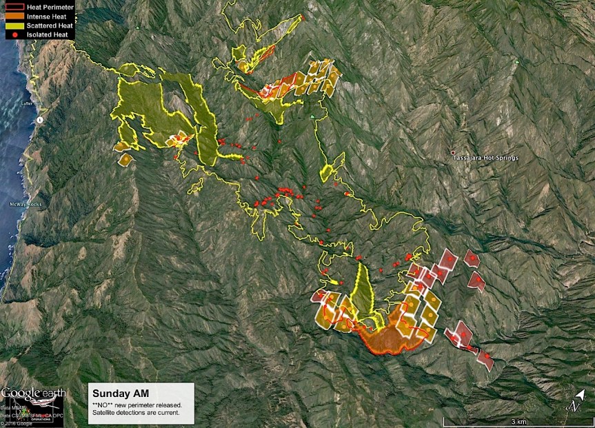
8:30 am – John Chesnut’s map for today:

image

4 am – Again, there is no IR map for today, but I would suspect, rather than an ill pilot, or plane maintenance, as were true the last two times, this time it was due to cloud cover. From what I could see up here, between the clouds and the high fog, a flight would not have obtained much, if any, information. Instead, I bring you the Briefing map of the NEW “Control Objectives.” The one on the southern end of the fire is no longer the dozer line cut to the east from Rodeo Flats, but is Nacimiento-Fergusson RD. This is a 96×96 map (whatever that means) and these maps always crash my PDF to jpeg conversion software, so it is a screen shot. However, I have included the link, as always, so one can click through to the map itself. Also note the ridge of high pressure is coming back so temperatures will be rising and humidity will be dropping through the weekend.

image

Briefing Map in PDF

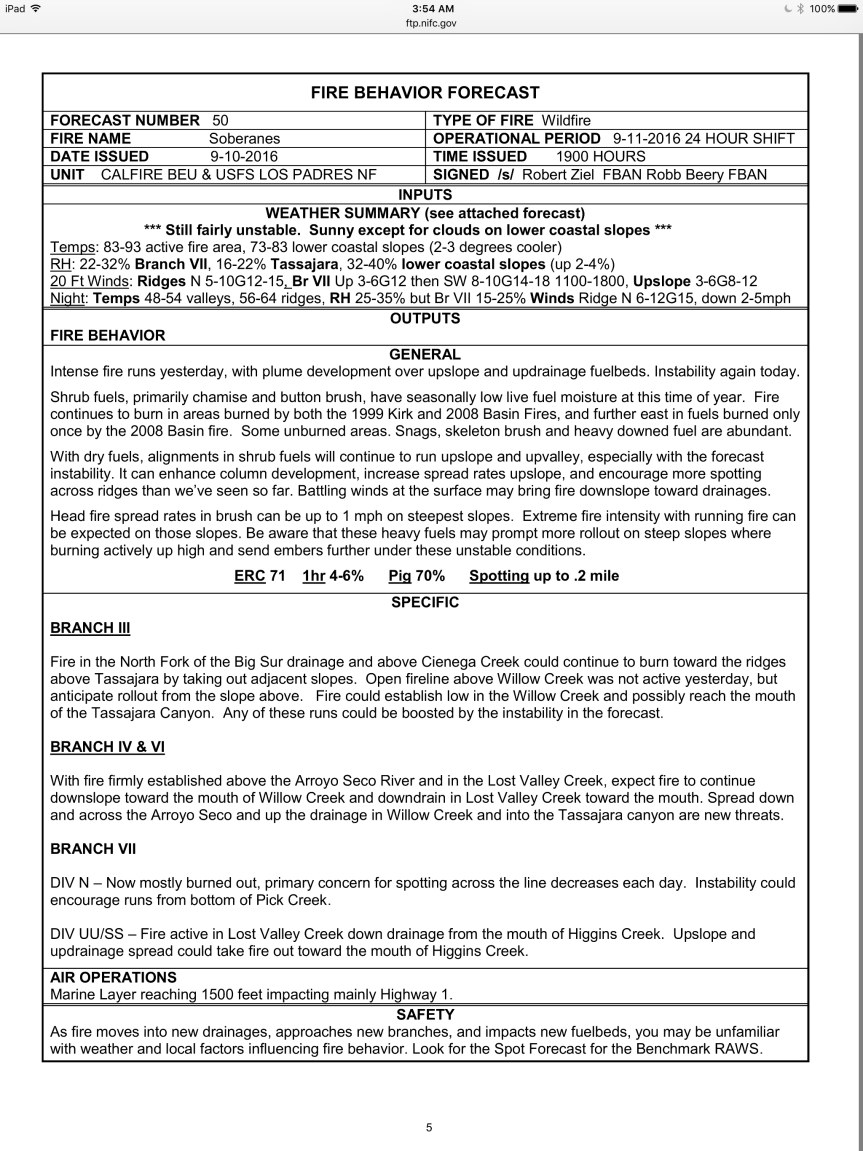
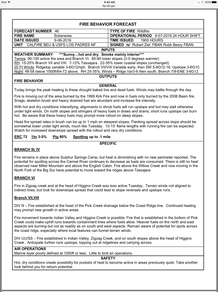
Here are the weather predictions and fire behavior discussions. Note, there are two of each – separate ones for each of the Eastern Operational area and the Western Operational area.

imageimage

imageimage

Here is an interesting chart:

image

Chart in PDF

Soberanes Fire, Day 54, 9/13/16

1:15 pm -0 Nicholas Buford, who provided us with the great first hand account of the firing operation at Anderson Peak last night has also sent some incredible photos. About them, he has this to say:

“Here are 2 photos of yesterday’s efforts that were probably obscured from view for most people below the ridge line.

The close-up is a shot at DP-106 looking South East (Marble Peak in the bottom right corner)

The second is from the Lower West Side of the ridge, looking East. The smoke being about a half-mile south of Marble Peak. This was the flare-up that they called in Air Support to help tame.

All the best,
Nick and Cordelia”

imageimage

Noon- from the USFS:

Soberanes Fire

Los Padres National Forest
Daily Update: September 13, 2016

CONTACT:
Fire Information Line: (831) 204-0446
Email: sobranesfire2016@gmail.com

Incident: The Soberanes Fire is burning in the Los Padres National Forest, Ventana Wilderness, in Monterey County, CA. The fire was started by an illegal campfire on July 22, 2016 in Garrapata State Park.
Agency Jurisdiction: CAL FIRE San Benito-Monterey Unit/Los Padres National Forest.
Incident Command: California Incident Management Team 4, Rocky Opliger, Incident Commander.

Current Size: 107,050 acres (69,856 acres CA-LPF; 37,194 acres CAL FIRE)
Containment: 60% Personnel: 1,384 Cause: Illegal campfire Injuries: 1 fatality, 7 injuries

Structures Destroyed:
57 homes, 11 outbuildings
Structures Threatened:
410
Crews: 20
Engines: 67
Helicopters: 17
Dozers: 8
Masticators: 2
Water Tenders: 7
Current Situation:

Today, the Soberanes Fire transitioned from the Alaska Incident Management Team to California Interagency Incident Management Team 4 at 6:00 A.M.

Last night firefighters successfully held the fire within indirect lines (firelines constructed away from the hot edge of the fire) and strategically ignited fires along portions of the indirect fireline. The fire also remains within existing containment lines. Main actions for today will be to continue strategic burning operations in the morning along the Coast Ridge Road, protecting structures in the Arroyo Seco area, and patrolling the fire area by air. Firefighters have also begun restoring bulldozer lines constructed early in the firefight in the northwestern area of the fire to prevent erosion and reduce other impacts.

On the coastal southwest side of the fire, crews continued to build bulldozer lines along the Coast Ridge Road for use as future control lines. Today, firefighters will continue securing this indirect control line as they progress to the south with firing operations; keeping the fire north of Rodeo Flats. Retardant has also been placed along Indians Road, about one mile and a half east of Anderson Peak.

On the east side, firefighters continue to focus on the Arroyo Seco area by pretreating indirect lines with fire retardant and continue to protect structures. The strategy is to keep the fire in the Ventana Wilderness, west of Carmel River and south of Willow Creek. Historic fire lines, constructed to suppress previous fires, are being reopened to minimize the effects to wilderness.

Yesterday evening, approximately 100 people attended a public meeting at the Arroyo Seco Fire Station and Community Center. Another community meeting will be hosted in Arroyo Seco on Thursday, September15, at 6 PM.
All Evacuation orders and warnings remain in effect.

For more information, visit: http://inciweb.nwcg.gov/incident/4888/ or follow us on social media at http://www.facebook.com/LosPadresNationalForest or http://www.twitter.com/LosPadresNF.

************************************************

10:30 am – Weather prediction from John Lindsey in SLO Co., whom I follow regularly:

“This system also will produce possible rain showers and isolated thunderstorms in the Sierra Nevada. Also of note: Moisture and instability will be limited, therefore a major
thunderstorm outbreak is not expected. However, given the elevated fire danger in the region, the risk of new wildfire ignitions because of lightning is a concern.

High pressure is forecast to build over California in the wake of the departing upper-level low pressure system Wednesday into Saturday for fresh to strong (19 to 31 mph) northwesterly winds along the coastline, mostly clear September skies, except for a few areas of overnight marine low clouds along the beaches and coastal valleys, and higher temperatures primarily away from the coast. At this time, rain is not expected through the end of September.

*************************************

John Chesnut notes: “From the IR read me file —
Weather Conditions –
The vicinity of the fire was heavily cloud covered.

Details –
Heavy clouds were present over the 80% of the fire. Small portions of the perimeter could be analyzed, especially the southeastern end of the fire. The majority of the perimeter is indicated as estimated.
A significant area of growth was noted along the southeastern portion of the perimeter.
Numerous isolated fires were detected within the perimeter.

Acreage –
Estimated Acreage: 107,050
Acreage Change (if any): + 1,323″ And here is his map: (BSK notes: very similar slop over on the coast ridge in both John’s map and Keith’s map posted last night and reproduced on my blog last night.)

image

6:00 am – I did find an IR Flight map, but it is really difficult to read, but does seem to show the new active fire line out by DP-107 to 108:

image

IR Flight Map in PDF

5:30 am – no IR Flight again today, but I did get a comment last night just after I went to bed that helps explain what happened on the western fire line last night. I just got to approving it this am, as I had gone to bed and a first comment from a reader has to be approved before it can post publicly.

“Hey all,

I’ve been up here with Cordelia Cluett at Marble Peak for the last couple days assisting the firefighters with their water operations. They had a successful burn yesterday at DP-106 and Marble Peak, and laid a retardant check line just a few hundred yards south of Marble Peak to contain the fire for the night crew. Around midnight last night, a dry wind came in and pushed the fire south through the check-line and made for quite an active night of trying to tame the flames. They even had to bring in some of the day shift around 4am to assist them in the operation. Around 10:30am we heard crews on the radio calling in air support to help douse some hotspots and start double-bomber lines of retardant perpendicular to the ridge to try and halt / steer the fire off the ridge. They pulled in crews from Northern divisions along to road to assist in today’s operations, setting engines all along the fire to pump hose-lines and stay with and ahead of the fire as much as possible. We heard air operations overhead all day today. From what we could discern from the radio traffic, the fire burned quite a few miles south along the ridge today, at least all the way to around DP-107. The day crew stayed with the fire until the night team was able to arrive and take over just about 40 minutes ago.

The weather here is quite cold and fogged in. Crews driving in and out are having a slow time working their way along the ridge due to visibility. It’s supposed to get into near-freezing temperatures up here tonight, and be fairly cool and dry for the next few days.

With as much activity going on along the ridge, there has been zero slop-over onto the western side of the ridge (believe me, we keep triple checking). The teams seem pretty confident in their efforts to tame the burn, as the main concern has been keeping the heat down. Where there’s fuel, there’ll be fire, but keeping it at a lower temperature will keep it from spreading too fast. That’s what most of today’s air ops were aiming to provide.

Will try to update with more pictures and information when we can.

All the best,

Nick and Cordelia”

It is quite cool (45 degrees) and foggy up here this early am, so should help with the containment lines up along the coast ridge this am. I’ll add what maps I can shortly.

Here is a briefing map that continues to resist conversion to jpeg, so this is a screen shot, but it shows where DP-107 is that Nick mentions. I do not believe the active fire line is up-to-date.

image

Briefing Map in PDF


Arroyo Seco Community Meeting 9/12/16

image

California Interagency Incident Management Team 4 has a website here:

CIMT-4 website

“In the Continental United States and Alaska there are 16 National Interagency Incident Management Teams categorized as Type 1 and 37 teams categorized as Type 2. Both types of teams are strategically located throughout states, which are more prone to wildland fires. The teams consist of members from a wide variety of federal, state, county, and local agencies. Region 5’s Type 1 and 2 teams generally manage large wildland fire incidents and address the most complicated safety, fiscal, planning, operational and logistical issues.”


Soberanes Fire, Day 52, 9/11/16

imageimage

10:30 am – Per Greg Fain at Tassajara Zen Center, there was no IR map last night as the pilot was sick. John Chesnut writes: “Attached is a map with a revised perimeter based on the OPS Branch VI topo map — hand drawn on GE. [Google Earth?] The OPS map has fire to the crest above Willow Creek, but not down the south bank slope. Fire to edge of the lower Lost Valley Creek, but not across up the north-facing south bank. Fire comes down an un-named drainage on the east to very near the Arroyo Seco.”

image

8 am – John Chesnut says: “No new perimeter for Sunday is on the Fire server. I check back after 10 or so. The VIIRS satelllite is current however (2 AM overpass).
The Radio chatter called in new air attack yesterday due to the spotting towards Arroyo Seco, so this is the best I can do on the spread toward that drainage.”

image

7 am – still no IR Topo Map, but here is the briefing map in screen shot, with a link to the original. I did find the acreage for today on the progression map – it is 105,642 for an increase of 1795 acres.

image

Briefing Map in PDF

image

Progression Map in PDF

And an evacuation status map for today:

image

Evacuation Status Map in PDF

5 am – many of you will be reflecting on 15 years ago on this date, and I honor that. I will be focusing on what is happening here … Now …

Given the run to the south east yesterday in the Willow Creek (East) drainage and the mandatory evacuation of Tassjara from Chew’s Ridge South, and the evac warning for Tassajara Road from Chew’s Ridge North and Carmel Valley Road east to Arroyo Seco, I was anxious to get up early and see the fire’s progression on the morning IR Topo Map, but no such luck. As of 5 am, it is still not posted, or not to be found. All the other information is available, but without this map, most of the rest is of no assistance because there is no frame of reference. I can add today’s fire behavior and weather predictions discussions though, and then I will come back in a couple hours and check on the IR Topo map again.

imageimage

Evacuation Order for Tassajara RD from Chew’s Ridge to Zen Center

U. S. Forest Service – Los Padres National Forest

SOBERANES FIRE: EVACUATION ORDER
9:00 PM
September 10, 2016

An evacuation ORDER for Tassajara Road from Chews Ridge south to the end of the road at Tassajara Hot Springs has been issued by the Monterey County Sheriff Department effective 9 p.m. on Saturday, September 10, 2016.

The previous evacuation WARNING continues for the Tassajara Road from Chews Ridge north to Carmel Valley Road and roads that leave from that section of Tassajara Road.

All residents covered by this evacuation Order need to leave the area. Be sure to take any medications, pets, important documents, and family valuables. Close all windows and doors before leaving.

Evacuation Warning Expanded on East Side of Soberanes Fire

SOBERANES FIRE: EVACUATION WARNING EXPANDED

RELEASE DATE: September 10, 2016 TIME: 18 00
SOBERANES FIRE: EVACUATION WARNING EXPANDED

An evacuation WARNING along the east side of the Soberanes Fire has been expanded to include an area along Arroyo Seco effective 6 p.m. on Saturday, September 10, 2016.

The new evacuation Warning applies to all residents southwest of East Carmel Valley Road starting at the intersection of East Carmel Valley Road and Piney Creek Road extending East to Arroyo Seco Road. It also applies to all residents along Arroyo Seco Road starting from East Carmel Valley Road extending west past the Arroyo Seco Campground.

An evacuation Warning is a precautionary notice that an evacuation Order may become necessary if the threat increases. The new Warning is due to the potential for the fire to spread toward these areas.

All residents under a Warning should prepare to leave the area. Be sure to take any medications, pets, important documents, and family valuables if asked to leave. Close all windows and doors before leaving.

(NOTE From BSK: I saw some impressive plume photos taken from the Zen Center earlier today that show new wildfire activity that appear to be somewhere in the Willow Creek drainage, per Steve Harper – the one on the east side of LPNF, not the Willow Creek down on the South Coast.)

Soberanes Fire, Day 50, 9/9/16

5:30 pm – Sorry, I was not around today. I had to go to Templeton, Paso Robles, and Cambria. I do intend to be home all weekend, however, so will be keeping an eye on things. From late this afternoon (about 1/2 hour ago) the incident report has this to say:

“Despite cooler temperatures and marine moisture in the morning at low elevations, open fireline became active by late morning with upslope runs carrying to ridgelines above. Aircraft was used to check fire spread in several areas.
Most activity was terrain driven through the burn period.
The most active burning was on the southern end of the fire. Fire continues to spread actively both down drainage toward Lost Creek and upslope on the slopes and ridges above it, both east and west. There was some active burning in areas at the bottom of Pick Creek beneath the area burned out yesterday.
There was also aggressive burning in unburned interior areas such as Cienega Creek and the North Fork of the Big Sur River. Managers continued to increase resource capacity on the east side of the fire in response to fire spread. Structure protection planning in that area was finalized. Managers also continued to scout opportunities for evaluation points and geographic locations that have successfully held previous fires.
The uncontained fire edge in Willow Creek did not show signs of significant growth today. Managers continued collecting data on previously used indirect lines on the southeast side of the fire. Previous fire control action points were scouted to be utilized as contingency lines.
Structure protection actions continued on Partington Ridge and south from Julia Pfeiffer Burns State Park to Dolan Road.”

7:30 am – John Chesnut’s Map:

image

5 am – here are the day’s maps:

image

IR Topo Map in PDF

image

South Ops Map in PDF

And the Fire Behavior and Weather Predictions:

imageimage


Soberanes Fire, Day 49, 9/8/16

7 pm – This is the afternoon MODIS from 1:20 pm today, by John Chesnut. This shows a couple of troublesome spots, one of which could impact Tassajara, if the winds align. Let’s hope they don’t.

image

image

8:30 am – One of the things I like about John Chesnut’s maps, is it is easy to see the topography of the land the fire is approaching and tell where the ridges and drainages are, which makes it a bit easier to see where the fire MIGHT go from here.

image

7:00 am – there is a very moving article about the fire by author Patrice Veecchione in yesterday’s Herald. You can read it here:

What the fires have left behind

6 am – today’s maps: (having trouble with uploading the maps again-but at least I can post the links here). Today’s Topo reveals the current acreage to be 102,499 or an increase of just over 1000 acres since yesterday. One map reveals that the distance between the now-contained Chimney Fire and the still raging Soberanes Fire has dropped another mile to 33 miles.

image

IR Topo in PDF

image

South Ops Map in PDF

imageimage

Soberanes Fire, Day 48, 9/7/2016

5 pm – here is a photo of the firing operation behind Anderson Peak by Cordelia Cluett:

image

Great photo, Cordelia. Thank  you for sending it.

Noon – from a resident of Partington Ridge: “I spoke with one of the firefighters this morning and they are headed back to Partington today because they are going to try and back fire a small area behind Partington that didn’t burn before…”

10:30 am – still  having trouble uploading maps, but did at least get the link for South Ops up, and finally showing enough of the south that I am in there. Here is the daily report:

The fire is still 2 1/2 miles south and west of Tassajara. Fire retardant is being used from the air to help manage the fire. Smoke plumes are visible from Tassajara, but the air quality in the Valley is good.
Total acres: 101,490
Acreage increase: 511
Containment: 60%
Total Personnel: 1,196
Temperatures are expected to be hotter today, with highs in the Interior of the fire expected in the 100-degree range. High pressure is moving inland, bringing moderated southwest winds over the fire area. The southerly winds could produce visible smokes for residents on the north end of the fire.
Fire is burning actively to the east along Zigzag Creek (picture below) and above the Willow Creek drainage. Fire is mainly moving through the heavier brush and dead fuels from the Basin Fire of 2008. Easterly fire growth on the ridge between Zigzag and Willow creeks is expected. This is creating short-lived columns of smoke visible from Tassajara and Highway 1.
There is some fire activity around Black Cone Mountain and the Willow Creek headwaters. Some fire activity south of the North Fork of the Big Sur River continues to spread as slope and fuels line up. Managers continue to monitor fire spread, hold and improve control lines and assess proximity and thread to indirect control lines.

6:30 am – this morning’s maps are being difficult and do not want to upload. Will be uploaded when cooperation is achieved.

image

IR Map in PDF


South Ops Map in PDF

If possible, I will load the weather and fire behavior discussions from the IAP:

image

image