
These were taken around noon (an hour ago) by Inga Dorosz. She says it is very active and you can see the dust all the way up top. Follow it up, and it is visible in her first photo – the long shot.


These were taken around noon (an hour ago) by Inga Dorosz. She says it is very active and you can see the dust all the way up top. Follow it up, and it is visible in her first photo – the long shot.
A blast from the past. Just found this. For those who don’t know, this is Rock Knocker when his hair and mustache were black.

Okay, for comparison, here is the one from 5/19 previously posted:

And here is the one from this morning. Both by Tafay Wilson. Note the dust and the new point. Unbelievable.

I took these on Friday.
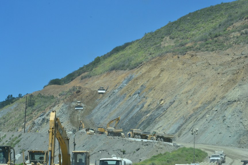


This is probably the spot of most concern, to me, as you can see the new nail wall is already cracking and giving way just next to that second cone up on the left. It is already extremely narrow, and those heavy trucks for the batch plant at the bridge can’t be helping.


And here, from Cow Cliffs, north of Big Creek:

Rock Slides have destroyed the fencing/catch netting. There were so many other places where the road is sinking, buckling, and all manner of protesting.
Heard and seen from Josh & Tafay Wilson’s front yard on Gorda Mountain – Photo by Tafay. The road is obliterated. And more is coming down. Went all the way down to the ocean.


Image CCRP 201501783 dated 09/11/2015 was obtained from the California Coastal Records Project website (http://www.californiacoastline.org/cgi-bin/image.cgi?image=201501783&mode=sequential&flags=0&year=current).

Image IMG 0899 dated 03/17/17 was obtained from Yeh and Associates for Caltrans (Gresh Eckrich <GEckrich@yeh-eng.com>).

And this is what it looks like now, as of May 17, 2017.
Mud Creek remains closed until further notice. Paul’s Slide hours an openings remain the same – see above in “sticky” post.
CALTRANS ANNOUNCES NEXT CONVOY TO PFEIFFER CANYON BRIDGE
MONTEREY COUNTY – Caltrans will continue the process of delivering construction equipment and materials to the site of the demolished Pfeiffer Canyon Bridge on State Route 1 via Nacimiento-Fergusson Road from US Highway 101 on Thursday, May 25.
These convoys will be escorted by the California Highway Patrol and will include intermittent closures of Nacimiento-Fergusson Road from 8 am until 7 pm. Motorists wishing to travel east/west in the morning must do so before the first convoy begins. Motorists will encounter delays during the movement of these four convoys westbound from 8 am to 10 am and 2 pm to 4 pm and eastbound from 11 am to 1 pm and from 5 pm to 7 pm. All vehicles should not exceed 30 feet in length and a weight of 15 tons.
These convoys will include the remaining 50% of the rock and sand necessary to create concrete abutments for the new bridge. Future convoys will transport two mobile batch plants, two concrete boom pump trucks, vacuum trucks and rebar cages. This equipment will be used to construct concrete abutments and overall construction of the new Pfeiffer Canyon Bridge (PM 45.52).

Mud Creek from South End

Aerial of Paul’s Slide
Unless there is yet another serious emergency, I am taking the day off. Barbara, thank you for these. They are gorgeous, and much better than a live bouquet! I can enjoy them for YEARS!


UPDATE, 5/19/17 at 7 am – Fresno county fire reporting 8200 acres, 40% contained
**************************************************
7:30 pm – Evacuations being issued for Parkfield Grade down to the county line. (that would be Monterey Co. line)
6:45 pm – 4,000 acres and 10% contained. BEU (Monterey/San Benito Unit) are sending resources now.
4:40 pm – 3,000 acres.
4:15 pm – 2,000 acres and long range spotting.
From Cal Fire: (Currently at 3:52 pm, it is 1500 acres with 0 containment)
Elm Fire Incident Information:
Last Updated: May 18, 2017 2:15 pm
Date/Time Started: May 18, 2017 1:11 pm
Administrative Unit: CAL FIRE/Fresno County Fire
County: Fresno County
Location: off of Hwy 198 & Alcalde Rd, south of Coalinga
Acres Burned – Containment: 1,000 acres
Road Closures: • Hwy 198 closed from Coalinga west to the Monterey County Line
Long/Lat: -120.37116/36.12089
Conditions: Firefighters are experiencing steep and rugged terrain and long range spotting.


