
This one was found this week by Sander Koning at the Grange. Note all the redwood duff?? Hard to miss the unburnt log, either…sigh…


This one was found this week by Sander Koning at the Grange. Note all the redwood duff?? Hard to miss the unburnt log, either…sigh…
There is an interesting article in Nature.com sent to me by Anni Agren on global mudslides. Of course, the cover photo is our own local phenomena. I love this global map, showing Mud Creek, California, as if it were a town.

The article is not accurate, at least as far as Mud Creek is concerned, “And after two years of slow movement, the Mud Creek landslide in Big Sur, California, rapidly wiped out half a kilometre of the state’s popular Highway 1 in May this year.” Mud Creek has been moving a helluva lot longer than 2 years. At least 37, according to Rock Knocker, who has the photos to prove it. Nevertheless, the article is worth reading Here.
Meeting today between all the responsible parties (and PIOs) re developing the time line for opening as well as projected costs. Will be released to the media (and others) at Susana’s update on Tuesday. Anxiously awaiting release.
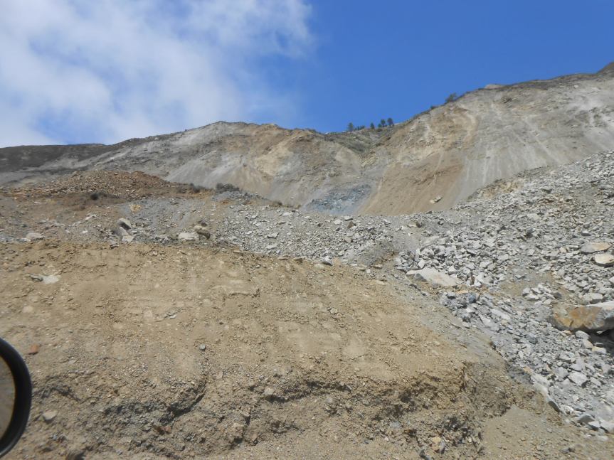
1) Photo of Mud Creek (PM 8.9) from last week attached; 2-3) Photos below of Pfeiffer Canyon Bridge Launching (PM 45.42) from last week.


HIGHWAY 1 UPDATE – Monday, August 28:
Highway 1 in Monterey County continues to provide 35 total miles of Hwy. 1 to the public from south of Gorda (PM 10) to just south of Pfeiffer Canyon (PM 45.5), accessible only via Nacimiento-Fergusson Road. State Route 1 remains closed from north of Salmon (just south of the Ranger Station (PM 3) to just south of Gorda (PM 10) due to the Mud Creek event. State Route 1 south of Salmon Creek is accessible via State Route 1 in San Luis Obispo County, past Ragged Point to Salmon Creek.
REMINDER: Travelers CANNOT travel the entire length of Highway 1, but local businesses are open on both sides of the closure points at Pfeiffer Canyon and Salmon Creek.
Mud Creek (PM 8.9)
Mud Creek had a major slide on Saturday, May 20, 2017, losing 5 million cubic yards of material. Caltrans continues with its plan to realign the existing terrain. A tentative cost and timeline are targeted to be announced next week. The roadway remains impassable.
There is no public access through the Mud Creek area as this is an active construction zone.
Paul’s Slide (PM 21.6)
Paul’s Slide continues to provide access to the public 24/7, with one-way reversing traffic control with flaggers.
Pfeiffer Canyon Bridge [PCB] (PM 45.52)
· The bridge launching over the canyon took place last week. Removal of the tower grillage and construction the cribbage at the abutments is next, in preparation
Just WOW is all I can say. Such an amazing engineering feat. Photo by Cal Trans. I like the American flag touch. 😉

A time-lapse video showing the movement pattern during the launch sequence can be viewed at https://youtu.be/29HByN_aXGo ; video courtesy of Kyle Evans for Caltrans.
Yesterday morning, Cal Trans held a media event at the launch of the bridge. At this event, it was revealed that the bridge might be delayed a bit into October. Here is what the CT representative told the SJ Mercury News:
“Right now, this operation is kind of an unknown for us,” said David Galarza, Caltrans’ structure representative for the project. “We have a schedule and we have predicted time frames, but because it’s kind of a new operation, it’s a bit of an unknown. We’re probably going to be (working) into October.”
Galarza gave no specific reason for his anticipation of a slight delay in opening.
Monterey County RMA is currently managing two projects on this road; (1) The Palo Colorado Emergency Repairs at Rocky Creek (Milepost 3.0 to 3.5) and Palo Colorado Storm Repairs from “the Hoist” to “Botcher’s Gap” (Milepost 4.0 to 7.5). Here is a brief summary on both:
The Palo Colorado Emergency Repairs at Rocky Creek (Milepost 3.0 to 3.5)
The repairs consist of replacing the existing damaged culverts underneath Palo Colorado Road at the Rocky Creek and Brandon Creek crossings. The culverts were damaged as a result of the 2017 winter storms and Soberanes Fire. The County has temporarily surfaced the road with aggregate base material on this section of damaged road and a placed temporary bridge near the Rocky Creek culvert crossing. The County is developing plans for the permanent fix as well obtaining the necessary permits for the resulting construction work. We intend to work on initiate the construction work on the permanent repairs as soon as all the regulatory permits are obtained and as long as weather permits.
Palo Colorado Storm Repairs from “The Hoist” to “Botcher’s Gap” (Milepost 4.0 to 7.5)
The repairs consist of reconstruction this 3.5 mile section of Palo Colorado Road. Dozens of culverts were damaged and several slipouts developed from the 2017 winter storms and Soberanes Fire. Given the extent and magnitude of the damages, the cost to repair this section of Palo Colorado Road is estimated to be over $10 million dollars. The County is currently in the process of negotiating and securing a contract with an engineering firm to develop engineering plans and obtain the necessary permits and clearance for this project. This is a longer-term repair project that may take 1-3 years to complete, provided the required project funding is secured.
Palo Colorado Road Repair Update (Updated 8/17/17)
Repairs at Rocky Creek (Milepost 3.0 to 3.5)
County is preparing plans to replace the existing damaged culverts underneath Palo Colorado Road and the Rocky Creek and Brandon Creek Crossings. The road has been temporarily resurfaced with aggregate base material and a temporary bridge has been placed near the Rocky Creek culvert crossing. Plans for permanent repairs are complete and County has applied for the necessary regulatory permits required to complete this work. However, permits will not be issued in time to begin construction before this rain season (October 2017-April 2018). Meanwhile, County is proceeding with bidding so that we have a contractor ready and so we can prepare as much as possible ahead of beginning construction in Spring 2018.
If we get heavy rains this year resulting in high water flows within Rocky Creek, County may need to pull the bridge temporarily to avoid damaging the bridge. County will monitor conditions throughout the winter and provide advanced notice of any action to pull the bridge.
Below is a brief outline of milestone dates for this project:
August 23, 2017; Walk through with contractors
August 29, 2017; Big Sur Land Use Advisory Committee Meeting to obtain Coastal Development Permit
September 8, 2017; Construction Bids Due
Fall 2017; Site preparation work prior to culvert replacement
Spring 2018; Construction expected to begin
Installation of Security Gate
County has scheduled installation of a security gate limiting access above the “Hoist” on August 24, 2017. This gate will be installed in the location where temporary barricades have been placed. Vehicle access beyond the gate will be limited to residents and emergency personnel. The gate may remain in place permanently to allow for temporary closures as needed, and will only be opened when road conditions above the Hoist are safe for vehicles.
Major Storm Repairs from “Hoist to Botcher’s Gap” (Milepost 4.0 to 7.5)
County plans to reconstruct this 3.5-mile section of Palo Colorado Road. Numerous culverts were severely damaged, as well as several slip-outs developed from the 2017 winter storms and the Soberanes Fire. County is working to get a Design Consultant under contract by November 2017 for the environmental and preliminary engineering. Repairs required for this project is expected to take 1-3 years to complete (2020), including design.
Communication
The County has designated a single point of contact for this project to receive questions and coordinate with agencies to provide a collective response:
Monterey County Resource Management Agency, Public Works Division
Contact: Christine Poe, Management Analyst II
1441 Schilling Place, South 2nd Floor
Salinas, CA 93901
(831) 755-5025
poec@co.monterey.ca.us
All calls and emails will be responded to as soon as possible. We will monitor conditions throughout the rain season and provide advanced notice of any actions via Chief Cheryl Goetz as well as the County’s website and social media.

Photos by J.R. Carmichael yesterday, 8/21/17 around 1:30 pm –


And here are some from Kyle Evans taken this morning, Tuesday:


Photos of Pfeiffer Canyon Bridge (PM 45.52) showing the final girder assembly and the launch nose and bridge deck prep work. Photo of Mud Creek in 1995—Courtesy of Rock Knocker.
HIGHWAY 1 UPDATE – Monday, August 21:
Highway 1 in Monterey County continues to provide 35 total miles of Hwy. 1 to the public from south of Gorda (PM 10) to just south of Pfeiffer Canyon (PM 45.5), accessible only via Nacimiento-Fergusson Road. State Route 1 remains closed from north of Salmon (just south of the Ranger Station (PM 3) to just south of Gorda (PM 10) due to the Mud Creek event. State Route 1 south of Salmon Creek is accessible via State Route 1 in San Luis Obispo County, past Ragged Point to Salmon Creek.
REMINDER: Travelers CANNOT travel the entire length of Highway 1, but local businesses are open on both sides of the closure points at Pfeiffer Canyon and Salmon Creek.
Mud Creek (PM 8.9)
Mud Creek had a major slide on Saturday, May 20, 2017, losing 5 million cubic yards of material. Caltrans continues with its plan to realign the existing terrain. A tentative cost and timeline is targeted to be announced at the end of August. The roadway remains impassable.
There is no public access through the Mud Creek area as this is an active construction zone.
Paul’s Slide (PM 21.6)
Paul’s Slide continues to provide access to the public 24/7, with one-way reversing traffic control with flaggers.
Pfeiffer Canyon Bridge [PCB] (PM 45.52)
· The girder assembly has taken place in preparation for the bridge launching over the canyon, expected to take place this week.
· Public access is still on schedule for mid-to-late September.
Caltrans reminds motorists to move over and slow down when driving through highway work zones.
For more information on this project and for traffic updates on other Caltrans projects in Monterey County, residents can call the District 5 toll free number at 1-831-423-0396 or can visit our website at: http://www.dot.ca.gov/dist05/paffairs/release.htm#mon
Susana Z. Cruz
Caltrans District 5
Public Information Officer


These were taken yesterday, 8/14/17, by Rock Knocker, who was escorted to the work area by Wayne Walker, the project manager. First, let me put to rest all the recent rumors people have been asking me about. No, Mud Creek is NOT going to open at the same time as the bridge, and NO, it is not going to open to locals only anytime soon. As has been said numerous times before, the timeline for the completion of this project is expected to be released by month’s end. Evaluation and prep work are still being done as of now.
First off, here is a recent aerial view to provide some perspective as to what one is seeing in the closer, on-the-ground photos:

Here are 15 of the ones Rock Knocker took yesterday, then I have added two historical ones.

That is the rock sea wall being built. It will come north to that “mound” just behind the pompas grass.

On can see the containers up on the left which are going to be used as a retaining wall.

Hauling in and moving rock


This first one is from 1995:

And this one is from 1994. I am told I already published this one, but worth repeating.


