BEST NEWS TODAY CONFIRMED:
“The [mechanized equipment] request was approved 90 minutes after the fire went into the LPNF. USFS worked hard in the early days to get all of that ready in case it came into the forest. What Bill Monning announced was that the Federal Management Assistance Grant (FMAG) was approved by FEMA – which provides reimbursement for state and local costs and recovery money.” Kathleen Lee, assistant to Supervisor Dave Potter,
From tonight’s Community Meeeting, partial notes:
Q: how confident are you in lines protecting CV? A:Last 5 years fire has been extreme which is why trucks are coming. direct on fire in DivC and creating 2nd line on RSC road & 3rd line on Chamisal ridge
Q What part of cv is most vulnerable? A: Robinson Cyn, Garzas, RSC. Hitchcock & other remote steep outlyers
Q: Update on Palo & Garrapata? A: Hard area. Structures lost. Damage team not able to get in yet. Intensity off charts 2 prior days, cooler today & some progress.
Q: Palo fire movement direction? A: generally backing west, south into little sur drainage, burning downslope . Moving twd bixby creek, backing down twd palo creek in road corridor. SOD logs light, burns fown…
Wants more general questions
Q: containment size & date A: % is relative. Projected date is Aug 31 now cause he knows more than he did
Q: Communicating w/absentee landowners, gas service? A: register w/reverse 911 and turn off your own gas. Help your neighbors. Feeling ‘very comfortable @ CH.
Q: What is up north of skinners, mt carmel, poinciano ridge & pine valley? A: structure protection first. Working on that long term w/ midelling
Q: No plan to close shelter if there is a need but nobody currently usong it. can be opened again immediately if reqd
*******************************
Sobranes Fire Conference Call Presentation
July 28, 2016 3 PM
Presenter: Chief Michael Urquides, MCRFD
Moderator: Forrest Arthur (The Preserve)
On the Preserve there are currently 40 fire engines, 20 bulldozers (at the end of the conference he said 30) and over 300 correctional fire inmates. There are 8 helicopters, 4 fixed wing air tankers.
As far as those that have been evacuated expect to be evacuated a minimum of 5 days. They look at it with 5 day blocks. They will have a better estimate after the weekend.
Williams/Trapper Area:
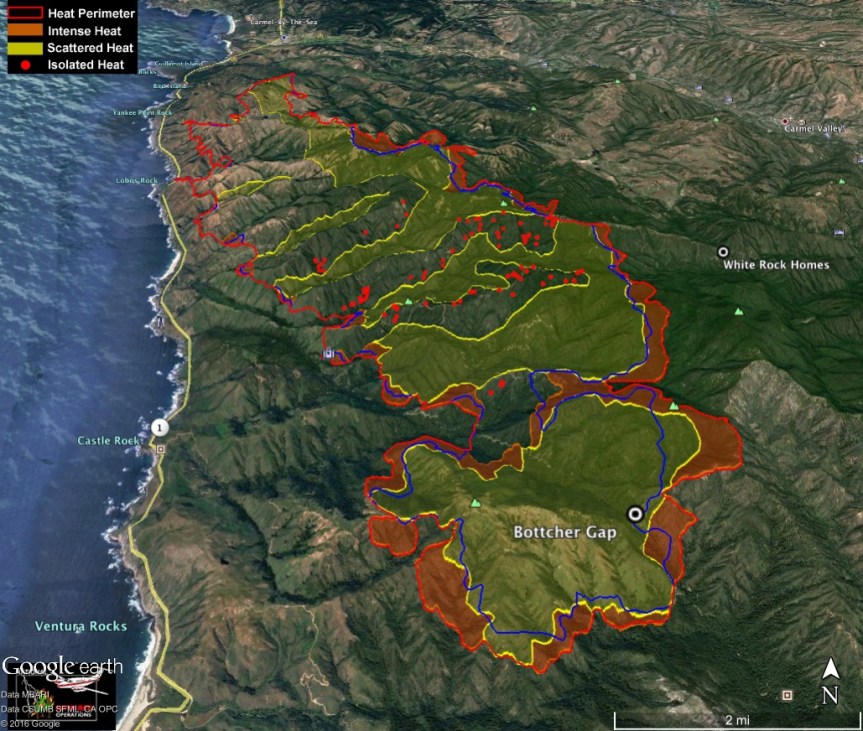
There are 4 areas currently involved. The Williams Canyon/Trapper area is most active currently. The others are Garzas, Spill Area and White Rock. In the Williams/Trapper area (what we saw last night) it is what they call a backing fire, a planned fire slowly backing down to containment by design. They are close to putting crews in to fight it on the ground. The fuel is not very volatile and the humidity is higher than expected. It is not too destructive. The upper fuel is not being involved at this time (top of trees). The conditions are great for the ground litter to burn. The fire has not yet jumped the containment lines at Williams Canyon but the concern is it is not big enough to contain it. They are not worried if it goes to Rancho San Carlos. Great break there. The helicopters are currently making drops in this area and will do so until sundown as they did yesterday.
Rear of Garzas:
This area is not volatile, just ground litter burning. Properties are defensible.
Spill Area:
(approximately 1 1/2 miles due west of the intersection of San Clemente Trail and Robinson Canyon Rd.) The fire is active, 4-5 acres here but not scary. It did jump the primary dozer line in this remote area. Strike teams and dozers have been dispatched to this area to begin the installation of secondary containment lines. This outbreak does not endanger any homes at this time.
White Rock:
One concern is containment for the fire. Rancho San Carlos Rd. is one large break. One concern is the fires burning on the E side of White Rock Mtn. and getting into canyons in the Valley (Hitchcock and Robles Del Rio areas). For this reason they are staging 150 fire trucks in this area. Other containment lines are CV Rd. and Highway 1. They are doing long term planning here, more rather than not enough.
Other General Information:
The weather is cooperating for troops on the ground. This is the number one fire in the nation now and there aren’t other big fires happening now. They have requested and are getting everything they have asked for. There have been no delays on the requests. This fire has already gone over $40 million to fight it, 4-5 million a day. The biggest cost is aircraft but the daily cost goes down when they are grounded because they are contract employees. 4,000 fire fighters are assigned to fight this.
There are trucks in every driveway of the preserve. This is precautionary. They are checking for embers. They have 20,000 feet of hose laid out. All hydrants on the preserve are used for top offs. Another concern is when the smoke clears the sun is out and makes things volatile. Fighting this is a delicate game. They can’t underestimate the fire and take it one day at a time. There is a lot of save haven in the preserve which is why they have so many fighter in there. They are able to make big containment areas rather than little island containment areas. The Preserve is like a little fire city with equipment. They prepare for the worst but hope for the best.
Regarding the maps which are developed by Intel they are done at 4 PM for fighting the next day. They are already 12+ old the next day. They also use a Type 3 Helicopter so they can have a better picture but the smoke makes that difficult too. The Incident Commander goes up in this to get a better picture for fighting the fire.
Fuel burning slowly is defensible. It will be smoky.
A note on the bull dozer operator that was killed. This was almost the same spot the previous dozer was killed.
There was an email address to send questions but it was given so quickly I didn’t get it. Forrest Arthur asked Chief Urquides questions residents had sent in. I will try and get that to you.
There is a community meeting at CMS tonight at 6 PM. I will attend and relay any new info.
Incredible community up here on the mountain!
Aletha
_____________________________________________________________________________________________MCRFD Add’l notes from same meeting by Lucas Ryan. Note costs at end, and prior dozer death at same location in 2007.
Chief Urquides
40 trucks and 20 Bulldozers at The Preserve.
5-day evacuation blocks at this moment. Not long term. Wait through the weekend. 5-day windows of opportunity.
Global picture – 4 quadrants
Williams canyon – Trappers – Garzas area: backing fire. planned fire couldn’t go direct because of ridgeline. By design. Eventually, FF will go in to put fire out. Fuel not volatile, humidity higher. Fire not backing down into rancho san carlos contingency road area. Fire not destructive to upper fuel bed, all duff driven, win win to keep fire out of trees – ground crews – conditions are great to just burn ground litter and not upper canopies.
Garzas – Fire close to the rear of the Garzas. Smokey conditions. Not volatile, A lot of FF’s doing great work. They are confident properties are defensible.
Spill area 1.5 mile west corner of San Clemente trail and Robinson – 4-5 acres contingency lines. Jumped Whiterock dozer line. Trucks on RSC road, concern is embers from backing fire fall onto west side RSC south facing grass.
CV village – Fire Dept. Big Box Line, CV road, Hwy 1, Cachagua. If the fire continues to loop around Whiterock, San Clemente, the canyons could align to CV village – Hitchcock Canyon. Don’t have any definitive fire breaks but are trying to put them in as we speak. They want to do long term planning – overplanning. FF’s in village proper, Hitchcock, Robles. New order for 150 truck for this area. Not much fire in western united states, #1 incident, so they are getting what they are asking for. Error side of caution because of severity of fuels. Weather is cooperative for troops, but not for airplanes. Sun will ripen the fuel to become volatile. Trying to get as much work done as smoke allows – without aggressive use of aircraft. Delicate game. CAN’T UNDERESTIMATE THE POTENTIAL OF THIS FIRE One day at a time. Calling for a lot more resources to be over prepared.
Entire Preserve effected? Pre-planning box – can’t undercut backside of preserve planning fire or division breaks, we include the whole Preserve. A lot of safe haven, we can stop from aggressively getting to Chamisal, but don’t want to make islands. Planning so it will not impact more than it has. Prepare for Worst, hope for best, calling a lot of resources to protect infrastructure of Preserve. Picture little fire city. Overplan, request resources in case the fire takes off. 5 day segments for evacuation, Maps – intel in at 4pm, 12 hours behind for fire data when they come out. Commander has type 3 helicopter to fly fire, but with smoke they can’t do that. Maps are a concern for FF’s and Public.
Proximity to RSC and the trappers. It is close. Slow, Smokey, no aggressive wall of fire. FF’s are confident. Defendable for any structures there.
Fire Fatality, 2007 Matt Will, the recent accident, Robert Reagan, was 1/4 mile from where that occurred. Last Dozer fatality was 2007 in the same spot. Just shows it is steep. Dozers are an amazing tool, but when you can’t go direct it causes challenges. 60 Dozers assigned and 30 on the preserve to safeguard homes.
Appreciative that the homes were protected in the Garzas, but 4 homes on West side RSC, 35, 39, 42, 44. They look great. Trucks in driveways to prevent embers falling in grass. Cache of hose – 20,000’ of hose pre-staged along RSC, water system working great, hydrants in service. Life first and then protect the environment. Nothing precludes us from protecting those homes.
Has fire jumped containment lines Williams canyon? It has not jumped, but we question the fire line strength. If it does jump then it’ll be at the bottom. They prepped BSLT cabins, the fire burned around, it is secure. If we can protect those cabins then we can protect homes. We will see fire from Williams canyon to RSC road by backing or FF will put fire on the ground to secure that line.
Any known cost of the fire? $40 million, 4-5 million a day fire. Cost is down because of aircraft – they can’t fly. When they can’t fly they don’t get paid.
Photo from Saddle Mountain looking toward Preserve, photo by Aletha

This evening from Clear Ridge, photo by Jen Smith

3:00 pm – From Michael Troutman

9:15 – A GOFUNDME account has been established for the wife and two daughters of the dozer operator who lost his life, Go fund me for Robert Reagan
A friend of Michael Troutman’s (ex USFS hotshot) found this amazing video. It is shot from inside the cockpit of a tanker. The green dots on the dash are the retardant level
Retardant drop (It has been taken down)
5:30 am – asked to let you know about this organization:
“July, 2016. Monterey, CA. The Community Emergency Response Volunteers (CERV) of the Monterey Peninsula, a 501c3 non-profit, has launched MontereyCo.RECOVERS.org in response to the Soberanes Fire recovery efforts. The website is overseen and staffed by Recovers Squad volunteers from CERT programs in Monterey, Seaside, Marina, and Pacific Grove. The website, https://montereyco.recovers.org, is a tool to build community resilience by matching people’s needs with resources in the community at a grass roots level. Local organizations and community members with specific needs as a result of the Soberanes Fire are invited to register and post on the site.”
5:00 am – had company stop by LAST NIGHT, with some lovely Holy Granola and honey from the Hermitage (thanks to all the monks for this) and a couple bottles of wine, and we shared stories and wine for a couple hours, it was a nice break last evening.
Today, after an exhausting 6 days, I will be taking some time off and will be off line from 10 – 2, while Mike Morales will be keeping an eye on the blog for me, and moderating comments, etc. I am taking Rock Knocker out to lunch in the Big Sur Valley for his birthday (it was yesterday) which will allow me a closer look at things up on the North End, and an opportunity to get a feel for what people’s concerns are, and where any help may be needed. During travel time and during lunch, I will not be monitoring, but before I leave, both home and lunch, I will check in.
In the mean time, I will be uploading my daily dozer maps when I get them, and other information that may be of help. One note I would like to make is in the comments people leave seeking information from others, these comments are often left in all sorts of different places, which will be hard to find, for example, one person waning to know about a specific place on Day 6, left a comment on Day 3, which is not likely to ever be seen by anyone now, 3-4 days later. Might I suggest those kinds of comments are best posted on the “locals” post for the day one is asking the question? More likely to be seen. Some great summaries and observations came out of last night’s summaries, but they are spread out among Day 6 posts.
One of the things I learned in covering fires for this blog is that I can get “up and running” and “up to speed” in an hour, whereas most sources of information might take days. That first week is critical in knowing what is going on. As “official” sources become more available, and more information becomes available through all sorts of sources, my blog becomes less critical and thus I can begin to slow down. I couldn’t possibly humanly keep up the pace I have been devoting to this until the end of August, the new containment date, so beginning today, you will start to see a slow down in the amount of information offered.