Soberanes Fire, Day 10, 7/31/16 – Maps & IR Log

To ZOOM in on a desktop computer – hold CONTROL and + (on mac COMMAND and +)

Operations MapOps Full

Legend

Legend

Public Information Map

PIO

Infrared Topo

IR Topo

Infrared with Satelite Image

IR Image

Infrared LogIR Log

Weather Forcast

Weather

Fire Behavior ForcastBehavoir

Dozer Index

file-page1

Dozer Maps

file-page2file-page5file-page6file-page9file-page10file-page11file-page12file-page13file-page14file-page15file-page16file-page17file-page18file-page20file-page21file-page24

Notes:

-Read more about the satellite heat detection here: xasauan today

-Adam Clark has provided an updated link for people to use if they don’t have Google Earth.  You can find it here:  Mapping Support (Black lines are completed Dozer lines and Blue lines are proposed Dozer lines, but they may not be current. Go to the Dozer maps for the most current info.)

-The weather information for the “blue WX rectangles” can be located at: MesoWest (link provided by Larry)

Scroll down to SC07 Central Coast. There are 6 IRAWS which stands for Incident Remote Automated Weather Stations. Each are labeled with a number and location. This page is a summary (refresh the page to get the latest observations) but there are hyperlinks to each station for more detailed information. UTC/GMT time zone is 7 hours ahead.

-Live Air Traffic can be found here: Flight Radar 24

Soberanes Fire, Day 10, 7/31/16 – Local Reports

An hour later and that plume from the south eastern edge is almost gone, and we’ve got this one from the south western edge. A burn out operation at the Golden Stairs south of Pico Blanco, maybe??

image

5:15 pm – current photo from my place:

image

4:30 – here is a visual of the area of the mandatory evac for Tassajara and parts of Cachagua (warning to the rest of Cachagua) Thanks to Lucas Ryan:

image

3:30 pm – A backfiring operation in the area of the Upper Preserve was successful to create that coveted “black line” of safety.

5 ATs out of Paso are on a flight path directly over my house. Yesterday there were 8 and several of them made their last run at dusk. Go pilots!! But put your safety first, please.

3:30 pm – from the 1215 hours MODIS flight sent by Jim Kasson:

imageimage

3:00 pm – Evacuation Center reopened at CMS; Those on Evacuation Warnings in Cachagua and Tassajara, pay attention for the issuance of a Mandatory, if the need arises.

1:30 pm – EVACUATION CENTER AT CMS RE-OPENS

11:00 am – South Side of Pico Blanco facing Post Summit last night. Photo by Matt Peterson or Derric Oliver

image

10:00 am –  Also from Cachuagua as a result of a back burn being undertaken:

From Cachagua Fire:
Cachagua Fire Chief Curry, along with Battalion Chief del Valle, are working with the Soberanes Fire Incident Management Team and the Monterey County Sheriff’s Office to hereby notify all residents of the Cachagua Fire Protection District that an evacuation warning is being issued.
Residents should know that the fire is approaching the boundary of the district and firing operations will begin today or tomorrow.
Smoke and flames will likely be visible within the Cachagua Fire Protection District as part of this operation. Smoke can be detrimental to the health of the young, old, and those with breathing or heart issues.
You may have received additional information via reverse 911 or from local media sources. We want to emphasize that this is an evacuation warning.
This is NOT a mandatory evacuation order.
For more information, you can contact Chief Curry

10:00 am – From San Clemente Rancho about 2 hours ago:

“To the south, the fire made amazing progress to the east yesterday burning through both the Big Pines and LIttle Pines areas of the Ventana…several miles at least! It is now backing down Blue Rock Ridge towards us (and the Cachugua).

To the West the Fire is making its way towards us via Ponciano Ridge and the South fork of the Black Rock Creek. It is now back out of the forest on our neighbors (the Lange’s & BLM) property.

Cal Fire has laid miles of hose line on the primary firebreak that Hank & I made but we still don’t have the air support everyone would like…the winds are predicted to shift, turning the smoke, not the fire) but that might come too late to help. Going to be a long next few days.”

Also hearing Evac warnings are to be given out to Cachuagua today.

****************

10:00 am – From Richard Cordova, Cal Fire PIO this morning.

Mount Manuel backfire planned for Monday, August 1, 2016
Cal Fire is planning a backfire on the eastern slope of Mount Manuel for Monday, August 1, if conditions are good. They are completing the dozer lines and advance work on this today. The plan is to back burn this section and join it with the larger fire. The timing is dependent on the weather. It may start in the morning but it could also be delayed until any time they determine the ideal conditions. Plan accordingly

****************

7:00 am – West Side of Pico Blanco, photo by Jen Smith

image

Photos by the Amazing Kodiak Greenwood of Pico Blanco and plume in background. Pico Blanco in this first photo is in the lower right. The burned ridge to the right and behind Pico Blanco is Skinner Ridge. The smoke-free mountain behind Skinner Ridge is Mt. Carmel. The big plume is rising from the Danish Creek watershed and Blue Rock Ridge (overlooking Cachagua) Per our resident expert, Keith Vandervere.

imageimage

Per Keith, the one above is looking from Pico Blanco down Dani Ridge (with retardant stripe) toward the confluence of the forks of the Little Sur and the ocean. The smaller plume of smoke is coming from the burn out operation at the top of Serra Grade on the Old Coast Rd.

image

The second is of Moon’s property. Looks to me like most of the structures are still in the green and probably survived. Moon’s road is visible at the bottom. The summit of Serra Grade is on the right. From this photo I’m not sure if this burning is really part of the deliberate burn out or not.

6:00 am – Dawn has finally arrived and I can visually see what is happening. No plumes, smoke is clear – fog socking in most of the coast, but doesn’t look to be very high. I have had an hour to check in, catch up on mail, and the like, and now ready for coffee. It really is a nice day to sit and watch the sunrise from this amazing perch and enjoy a brief respite of calm before the frenetic day of fire reporting begins. Remember to take a moment for yourself, take a nap, if you can. They can do wonders to rejuvenate you. Current IR Topo map puts fire at 38.007 acres. Lucas is busy putting together our maps for us.

Images: Soberanes Helibase, Carmel Valley

Post and photos by Mike Morales, my assistant admin. He forgets to give himself credit, so I will. 😉

Most of the assembled fleet of helicopters at the helibase in Carmel Valley stayed on the ground yesterday. There were 13 helicopters on the ground when I viewed the setting near noon. There’s a buzz of activity surrounding these airships with mechanics, ground crew support personnel and fuel trucks. Most of the birds are on contract so each contracting company has their own support team. It adds up to quite a lot of action at the grass field, Carmel Valley Vintage Airport.

Helibase, Soberanes Fire July 29, 2016
Soberanes Fire Helibase, Carmel Valley

Cal Fire Copter 406 flew in and as it landed around eight men who looked more like a security detail than firefighters hopped out and formed a perimeter around the aircraft, facing outward. I thought a dignitary was about to disembark, none did. It’s likely this crew was preparing for a VIP tour at some point later in the day. It would not be surprising the see the governor or a high placed fed come in for a look through.

Carmel Valley Helibase
Soberanes Fire Helibase, July 2016

Soberanes Fire, Day 9, 7/30/16 – Maps & IR Log

Posted by a new writer for my blog, Lucas Ryan, who is handling all maps, and anything map related. Maps were taking up so much of my time. Thanks for coming on board – lifts a huge weight off my shoulders.

To ZOOM in on a desktop computer – hold CONTROL and + (on mac COMMAND and +)

Operations Map (zoom in to see Dozer lines – they did not release individual Dozer maps today)

Ops Map

Public Information Map

Public Information Map


Infrared Topo (less topo detail than previous maps)

IR topo 7-30-16

Infrared with Satelite Image

IR with Image

Infrared Log

Log

7:30 am – from John Chesnut:

North End SaturdaySouth End Saturday

Google Earth with Dozer line overlay, fire activity, and fire perimeter.  Red lines are completed Dozer lines.  Green lines are proposed Dozer lines. See comment section for a link to the Google Earth KMZ Dozer file. Read more about the satellite heat detection here: xasauan today

Dozer thick (1) 7-30-16


A zoomed in view. Red lines are completed Dozer lines.  Green lines are proposed Dozer lines.

Dozer thick (2)

Note (see most recent Maps & IR Log post for an updated link):

Adam Clark has provided a link for people to use if they don’t have Google Earth.  You can find it here: Mapping Support (Black lines are completed Dozer lines and Blue lines are proposed Dozer lines)

Progression GIF animation courtesy of Dirk Reynolds

giphy


Soberanes Fire, Day 9, 7/30/16 – Local Reports

11:45 pm – and it is almost tomorrow, and I am headed off to bed for hopefully a solid 6 hours. G’nite, all.

This is a picture taken this/Saturday evening at 8:30 PM of the fire. The picture is taken facing west from the Hennickson’s Ridge firebreak. The long, low, dark mountain in the foreground on the left half of the image is Elephant Mountain.

You may post it on your blog.

Image copyright Eric Hulteen 2016

Eric

image

From Aletha Parker in CV:

image.png

9:30 pm – Dani Ridge from Ed VanWeijen on Clear Ridge:

This slideshow requires JavaScript.

Mt. Manuel retardant drops just occurring. BTW, I have 8 tankers out of Paso that have been flying over my house all afternoon. Love to hear that sound.

Okay, the first overview shot is by Mike Gilson, Apple Pie Ridge is in the lower right, the two close ups are by Ed VanWeijen, all taken from Clear Ridge:

imageimageimage

Photos from Mescal Ridge taken earlier:

This slideshow requires JavaScript.

6:00 pm – 2 photos of Pico, first by Eduardo Eizner from Clear Ridge moments ago, the second by Bigsurkate from my ridge:

imageimage

Photos from Ventana this afternoon:

image

5:30 pm – First, a shout out to Chris Chris Lorenc for bringing the issue of media access to everyone’s attention. I just got off the phone with Cal Fire Capt. Cordova and explained the situation. He was not aware of the private road status of Rocky Creek, Long Ridge and Green Ridge. Trespasses on private property are actionable,

I told him there were MANY, MANY private roads in Big Sur, Cachugua, Tassajara and the like. He promised to work with the MCSO to identify these roads and post them with NO MEDIA access signs.

We made a difference today, and it started with Chris Lorenc and became a ground swell of all of us banding together to make sure to right a wrong. We did good! Thank you all.

5:oo pm – South Side of Pico Blanco, Photo taken by Mike Gilson from Clear Ridge.

image

1:30 pm – Photo of taken from Mescal Ridge by Partington Chump about 1-2 hours ago, or 11:30-12;30.

image

If you want to see a almost 360, go to his FB page.

COMMUNITY MEETING TONIGHT AT CHS AT 6 PM

image

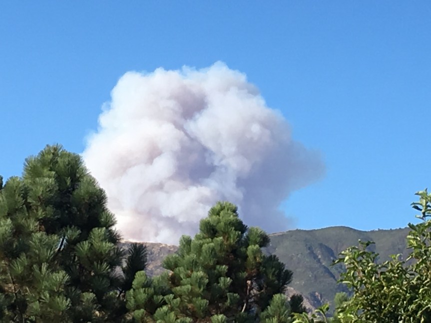
11:25 am – huge plume developing from Pico Blanco area.

10:54 am – flames top Pico Blanco. Here is a photo from Jen Smith from top of Clear Ridge:

image

10:00 am – interesting news article on Yahoo news that states:

“The blaze is estimated to have a final size of 170,000 acres (265 square miles), according to California Interagency Incident Management Team 1, which is comprised of federal, state and local authorities. The cost of fighting the fire is now at about $6 million a day, it said on its Twitter feed.”

The link to this article is Here

8:00 am – this is the letter I just sent to all the powers that be for which I have email addresses, including the USFS Forest Supervisor. I hope it helps:

“Do you you have any idea how much pain you are causing by escorting photo journalists onto people’s property to photograph the devastation without the consent of the owners? There are so many homeowners who are absolutely outraged to see their homes destruction – FOR THE FIRST TIME – spread far and wide through huffington post, KSBW, and perhaps others, I don’t know about.This really is about as insensitive and irresponsible as it can get. The home owners are not allowed access, but the media is? I don’t know if this can be rectified, but it can be stopped. So stop it, NOW.”

bigsurkate

6:00 am – Good morning everyone! Managed another 6 hours of solid sleep, so should be a good day. Lots going on today with the addition of a second full-service fire camp at Rancho Canado for an additional 2500 fire fighters. A smaller camp to serve up to 500 is being established at Pfeiffer SP. The fire camps are for firefighters and support staff ONLY. They’ve asked the public not to come onto the camp. Also, no donations needed for the camp, so please do not bring. Setting up car camping and meals at the Calvary Church on Highway 68 for evacuees starting at noon today. Also, Tillie Gort’s is offering free dinners each night to evacuees.

Lucas Ryan is busy setting up the IR Maps, etc. page for me this morning which will include the IR topo map. Thanks, Lucas, for a lifting a huge weight off my shoulders.

Lastly, for this early morning post, XT has posted some great overflight photos he took yesterday, here: Xasauan Today if you can’t get the link to work, just goggle Xasauan today and you will find it. Oh, and a working link to his site is on the right side bar under LPNF Links. Scroll …

Soberanes Fire, Day 8, 7/29/16 – Dozer Maps

imageimageimageimage

image

imageimageimage

The number of maps has drastically increased, so I’ll be loading them in groups of 3 until done. They are a PIA to make sure they are loaded in order.

imageimageimage

Three at a time works really well, unless I get sidetracked. Here are the next three 10-12

imageimageimage

And the next 13-15

imageimageimage

And lastly, 16-19

imageimageimageimage

Soberanes Fire, Day 8, 7/29/16 – Official Reports and Maps

8:00 am – Facts sheets below. We are now into the second page:

imageimage

6:30 am – getting this post up, but nothing “official” yet. I am uploading the Dozer maps, as usual, to their own page. (Brain still fuzzy- probably too much sleep, almost 7 hours!)

Operations Map for 7/29/16: Boy, in studying this map, it seems one critical need today is to connect up the finished dozer line in Div M to the finished dozer line in Div J through Div K. It is a no brainier, or the fire can hook around from Div M.

image