For more information, please visit watchduty.org. This fire is located East of Tassajara Road, on Carmel Valley Road, near the Hastings Reserve. The cause is under investigation. The acreage is currently around 180 acres. Nighttime helicopter operations have been ordered. PG&E is working on getting the power back on as of 6:08 pm.
Evacuation warnings have been issued for Zones MRY-D074-A & MRY-D076-A on the Genasys Evacuation Map. These zones are also visible on the Watch Duty map.
A Temporary Evacuation Point is at the Carmel Valley Library, 65 W. Carmel Valley Rd Carmel Valley, CA 93924 – per the update at this link
The National Weather Service has issued a Flash Flood Watch for the 2020 Dolan, River and Carmel Fire Burn Areas as well as the 2021 Willow Fire Burn Areas in Effect from Sunday afternoon through late Sunday night. The Flash Flood Watch includes a portion of northern California including the following areas, Santa Lucia Mountains and Los Padres National Forest with Lingering showers on Monday. You should monitor later forecasts and be prepared to take action should Flash Flood Warnings are issued. More Info: https://inws.ncep.noaa.gov/a/a.php?i=62818668
“In Northern California, it has been a good old rainy week. Many spots have seen a couple inches or more; nearly everywhere has seen at least enough for some modest puddles. In some areas, the amount of rain that has already fallen is probably enough to greatly attenuate or end fire season. “
“…one of the strongest October storms in some years (perhaps a decade or more in some NorCal locations) will likely occur on Sunday. This moisture delivery system will be in the form of a strong atmospheric river.”
“Stormy conditions are expected to begin early Sunday and ramp up through the day in NorCal. “
“Very intense rainfall rates of 1/2 to 1 inch per hour will be possible for a couple of hours“
Daniel Swain is the man weather wise. He just posted this on twitter: Seeing a “category 5” #AtmosphericRiver in central California in Oct would be extremely impressive, yet that’s looking increasingly possible on Sunday. With record-dry soils, impacts will be different than mid- winter event. Risks highest near wildfire burn areas. #CAwx #CAfire
__________
Open letter to Dear Frank Linnenbrink from Lucas Ryan. If you don’t know Frank, he is one of the kindest people you’ve ever met. Thank you Lisa, and everyone who is caring for Frank.
Frank, you are always there for us. Thank you for taking us to Church. We will always think, what would Frankie do? With so much love, thank you! We appreciate you, words cannot describe, actually, completely shattered right now.
Please, ride on! (so fast) We’ll be catching up withyou soon (no chance)
(Frank worked as a lineman for PG&E for many years. We rode motorcycles together. He actually married my wife and I, and many others. Frank is an all-life minister, and popular amongst the Big Sur community. Please send thoughts and prayers, as he is in the late stages of battling a serious illness. Frankie passed away around 11:45 pm, October 20th -Lucas Ryan)
Thank you signs are the least that we can do to show our support for all the Firefighters, Law Enforcement, Support Personnel, and Volunteers who helped with the Carmel and River fires. Here are a few signs that are posted up around Carmel Valley Village. And, thank you for all that you do!
Carmel Fire (Day 9) and RiverFire (Day 11) post. Unless things change, today’s post will be the final daily update for these fires. River Fire is at 48% containment and Carmel is at 45% so it seems we have turned the corner on these two fires. Please refer to the Office of Emergency Services response page here for updates. A big THANK YOU to all the Firefighters and Volunteers!
CalFire Incident page Carmel & River CalFire Facebook Updates here. Sheriff Facebook Updates here. Monterey County Office of Emergency Services Facebook here
River Fire: 48,424 acres burned, 48% contained, 1,183 personnel assigned, 13 residences destroyed, 17 other structures destroyed, damage assessment is ~90% complete.
Dolan Fire: 20,397 acres burned, 15% containment.
Morning Briefing 7AM:
“This is Soberanes land. Many of us spent a lifetime here.” “We need every one of you, every one of you, to finish this incident, go to the next, and get home to your families safe and sound, with stories and not scars.” “Collectively, you bring order to the chaos that was occurring here just a week ago … Thank you for all you’re doing.” -Cal Fire Chief Thom Porter
“We are in a marathon” “… the battle is not over until you’re home with your families”. – Unified Incident Commander George
7:15 AM: Carmel and River Fires Google Earth Image with VIIRS and MODIS Satellite and CDF Infrared Outline (from 08/25/20). The Latest satellite heat detection spots are from Monday at 11:25 PM. Note: the red circles inside the fire outlines are not new satellite detections. They are isolated heat sources as detected by an infrared camera mounted to an airplane.
Residents can access comfort kits, Personal Protective Equipment and bottled water at a Commodity Point of Distribution (C-POD). C-PODS have been set up at:
Carmel Valley Village near Meg’s Chevron and
Tassajara Rd and Carmel Valley starting August 25, 2020 from 5:00pm-8:30pm and will open again on Tuesday, August 26, 2020 from at 8:00am – 8:00pm.
Evacuation Map can be found here (Red is Order, Yellow is Warning, Green is Lifted) The map below is from 8:30 AM:
Carmel Fire (Day 8) and RiverFire (Day 10) post. Click the title to open in a separate window, and refresh this page throughout the day. Please be patient with CalFire and Monterey County Sheriff as they release information about the status of the fires and the evacuation orders. Thank you.
CalFire Incident page Carmel & River CalFire Facebook Updates here. Sheriff Facebook Updates here. Monterey County Office of Emergency Services Facebook here
The evacuation ORDER and WARNING covering Zone 19A on Esquiline Rd as it travels south, it becomes Southbank Rd which becomes Hitchcock Rd is being LIFTED.The evacuation ORDER and evacuation WARNING covering C-Zone 5 all areas south/west including Tassajara Road from Miller Canyon to East Carmel Valley Road to include Chew’s Ridge, Kincannon Road, Lambert Flat, Parrot Ranch Road and tributaries. Tassajara Road west to Miller Canyon, including Miller Canyon is being LIFTED at 5:00 PM on Tuesday, August 25th, 2020
River Fire
The evacuation ORDER and WARNING covering R-Zone 7 West of River Road from Limekiln Road to Gonzales River Road AND R-Zone 13 A all areas and roads west of River Road to Palo Escrito Peak and extending south from Gonzales River Road to Puma Road is being LIFTED at 5:00 PM on Tuesday, August 25th, 2020. The EVACUATION ORDER for R-Zone 13 to include all areas and roads east of Carmel Valley Roadto Palo Escrito Peak from south of Tassajara Road to Finch Creeknot to include Carmel Valley Road REMAINS IN PLACE.
Residents can access comfort kits, Personal Protective Equipment, and bottled water at a Commodity Point of Distribution (C-POD). C-PODS have been set up at 1) Carmel Valley Village and 2) Tassajara Rd and Carmel Valley starting August 25, 2020 from 5:00pm-8:30pm and will open again on Tuesday, August 26, 2020 from at 8:00am – 8:00pm.
Some homes may still be without water and water systems may have lost pressure or was disconnected from electrical power for a period of time, it is advisable to make sure it is not contaminated with coliform bacteria. To see if your well and piping system maintained positive pressure during the fire, turn on a faucet in the household to see if water comes out. You should not hear any air being released from the faucet. The flow of water should be steady and uninterrupted. If you do hear air escaping from the faucet with water intermittently spurting out when it is turned on, that is an indication that the well and household plumbing had a loss of pressure and should be checked to make sure it is bacteriologically safe. More at https://www.co.monterey.ca.us/government/departments-a-h/health/environmental-health/general/recovering-after-a-wildfire
The Evacuation Order for Zone 1a and 2a have been lifted as of 3:00 PM on Tuesday, August 25th, 2020. These areas include Pine Canyon Rd. west of Mesa and Berry Dr. west of Enos Dr.
Evacuation Notificationshere (note: select the DASHBOARD tab from a desktop computer for a detailed map with hot spots plus evacuation zones)
Evacuation Map can be found here (Red is Order, Yellow is Warning, Green is Lifted) The map below is from 5:30 PM:
River Fire 48,424 acres 33% contained, Carmel Fire 6,695 acres 30% contained, Dolan Fire 20,091 acres 10% contained.
1:15 PM: Carmel and River Fires Google Earth Image with VIIRS and MODIS Satellite and CDF Infrared Outline (white line from 08/20/20). The Latest satellite heat detection spots are from Monday at 1:54 PM: Carmel_River_Fire2_082520
7:00 AM: Carmel and River Fires Google Earth Image with VIIRS and MODIS Satellite and CDF Infrared Outline (white line from 08/20/20). The Latest satellite heat detection spots are from Monday at 2:48 PM: Carmel_River_Fire_082520
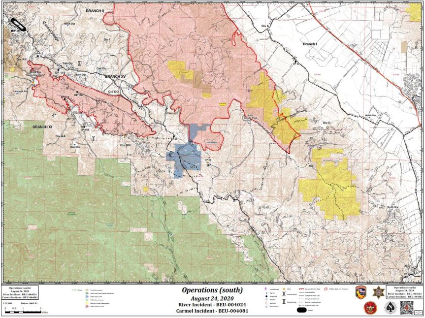
Carmel Fire (Day 7) and RiverFire (Day 9) post. Click the title to open in a separate window, and refresh this page throughout the day. Please be patient with CalFire and Monterey County Sheriff as they release information about the status of the fires and the evacuation orders. Thank you. CAL FIRE NEWS RELEASE California Department of Forestry and Fire Protection Media Line: 831-647-6257 Release Date: August 24, 2020 Public Information: 925-532-5455 Time: 1:00 P.M. RIVER AND CARMEL FIRES REPOPULATION WHAT: Evacuation Orders and Evacuation Warnings Lifted on the River and Carmel Fires DATE/TIME: August 24, 2020 at 1:00 P.M. WHERE: Areas of repopulation in the following zones EVACUATION ORDERS LIFTED: • Zone 1: Pine Canyon Rd, Parker Rd, Laurel Ln, and Trimble Hill Ln. EXCEPTION: Pine Canyon Rd west of Mesa REMAIN UNDER EVACUATION ORDER • Zone 2: South of River Rd from Tara Dr to Pine Canyon Rd to include all roads off Las Palmas Pkwy, Ranchito Dr, Indian Springs Rd, Redding Dr, and Belmont Circle. EXCEPTION: Berry Dr west of Enos Dr REMAIN UNDER EVACUATION ORDER. • Zone 4: Southwest of Parker Rd, northwest of Corral De Cielo Rd, and Rana Creek. Southeast of the intersection of Chualar River Rd and River Rd, northwest of Limekiln. • Zone 5: Harper Canyon area, all areas within north of San Benancio Rd, west of Troy Ln, southeast of Harper Canyon Rd, to include Harper Canyon Road, Weather Rock Way, and Rimrock Canyon Rd. • Zone 6: West of River Rd from Parker Rd, South to Limekiln Rd to include Limekiln Rd. • Zone 8: All areas south of Highway 68, east of San Benancio Rd to include San Benancio Rd south to Harper Canyon Rd
• Zone 10: All areas south within the intersection of Hwy 68 and River Road to Tara Drive and Hwy 68 south to San Benancio Road, including the Los Palmas 1 and 117 Drive Communities. This order does not include the Toro Regional Main Park area. EVACUATION WARNINGS LIFTED: • Zone 3: Indian Canyon, Mt. Toto Access Rd and San Benancio Rd from Troy Ln to Corral de Tierra, including Corral del Cielo Rd, Lucie Ln, and Covie Ln. • Zone 9,11: Areas North of Highway 68 from Portola Drive and Veronica Drive/Estoque Place east, to include all roads off Portola Drive to Creekside Court. THERE WILL BE ROAD CLOSURES AT: • Pine Canyon Rd at Mesa Rd • Berry Dr at Enos Dr To view the River and Carmel Fires Evacuation Map please visit: https://www.co.monterey.ca.us/government/departments-a-h/administrative-office/office-of- emergency-services/situational-awareness/public-alert-warning SAFETY MESSAGE: The public is reminded to stay vigilant on current fire conditions. Please continue to adhere to road closures and evacuation orders or warnings. If you see electrical wires on the ground, stay clear and contact PG&E immediately. For those who may be utilizing backup generators, please review the generator use safety information at https://www.pge.com/en_US/safety/electrical-safety/electric-generator-safety/electric-generator- safety.page?WT.pgeac=PSPS_FAQ-GeneratorSafety. Trees and poles with deep charring, particularly if still smoldering, should be considered hazardous. Please drive slowly and yield to emergency personnel in the area. Please visit http://www.co.monterey.ca.us/government/departments-a-h/health for public health or https://www.co.monterey.ca.us/government/departments-a-h/health/behavioral-health for behavioral health concerns. For additional information on the River and Carmel Fires, Monterey County residents should contact River and Carmel Fires Information Line at (831) 647-6257or 211. To sign up for emergency alert notifications visit: http://www.alertmontereycounty.org For more information on wildfire, visit CAL FIRE online at http://www.readyforwildfire.org ###
The Evacuation Orders and Warnings covering the areas of Carmel Valley, Corral de Tierra, and San Benancio are being lifted effective at 9:00am on Monday, August 24, 2020. This covers the entirety of evacuation order Zones 17, and 18 and the northern portion of Zone 19. The Evacuation Warnings in Zone 20 and 21 are also being lifted. The southern portion of Zone 19 from the intersection of Esquiline Rd. at Carmel Valley Rd remains under an Evacuation Order. As Esquiline Rd travels south, it becomes Southbank Rd. which becomes Hitchcock Rd and will form the northern boundary of the current evacuation order. (click image to open map, please see additional Warnings/Orders below)
**Cancelled** Red Flag Warnings is still in effect through 5:00 p.m. Monday for dry lightning with gusty and erratic winds. Potential gusts as high as 65 mph can be expected with thunderstorms(North State Red Flag Warning still in effect). Still, a threat of pop-up thunderstorms, and somewhat of a lighting threat. Big terrain-driven “swirly” winds on the River Fire. Westerly influenced winds on the Carmel Fire. Temperatures are the same as yesterday, humidity is up.
CalFire Incident page Carmel & River CalFire Facebook Updates here. Sheriff Facebook Updates here. Monterey County Office of Emergency Services Facebook here
7AM CalFire Incident Briefing (video starts at 4:40, see detailed Day Operations Plan at 12:00, please note thedate is incorrect on the title):
River: 48,424 acres, 23% contained, 1,274 personnel assigned, 8 residences damaged, 8 residences destroyed, 1 minor structure damaged, and 13 minor structures destroyed, damage inspection is 50% complete, delivered 305,000 gallons of water and over 281,000 gallons of fire retardant.
Carmel: 6,695 acres 15% contained, 909 personnel assigned, 5 residences damaged, 35 residences destroyed, 16 minor structures damaged, 2 minor structures destroyed, damage inspection 54% complete, delivered over 197,000 gallons of water and over 9,000 gallons of fire retardant.
Dolan: as of 8PM, 19,287 acres, 10% contained, 579 personnel.
“Facts to know: In 2019 we only had 13,000 acres burned in all of California. As of 2020, we’ve had over 500,000 acres burned, so these are unprecedented times.” -Unified Incident Commander
“…these fires are in very sensitive archaeology rich area, in particular, the Carmel Fire … we’ve already have a few sites that have gotten hit … if you see this (special zone flagging) if at all possible, keep the equipment out of there.” -CalFire Archaeologist
9:45 AM: Carmel and River Fires Google Earth Image with VIIRS and MODIS Satellite and CDF Infrared Outline (white line from 08/20/20). The Latest satellite heat detection spots are from 3:24 AM PM. (please see Important Caveat note at the bottom of this post)
Evacuation Map can be found here (Red is Order, Yellow is Warning)
Resources for Evacuees
Monterey County is expanding its evacuation shelters to south Monterey County. Due to additional evacuations from the River Fire, an evacuation shelter is being opened at the Salinas Valley Fairgrounds, 625 Division Street in King City.
The shelter will open Sunday morning, August 23rd at 8 am and will provide sleeping and meal accommodations. Evacuees who wish to shelter using their RVs can bring them to the fairground and check in at the shelter. This shelter will be able to accommodate evacuees with pets.
The shelter will be able to accommodate approximately 40 residents and will follow COVID-19 protocols. Evacuees should have face coverings when entering the shelter and be prepared to social distance. Shelter sleeping arrangements are being set up with COVID-19 health protocols. Temperature checks will be taken for everyone’s safety.
Here is a list of all county evacuation shelters:
Here is a list of all county evacuation shelters:
Salinas Valley Fairgrounds, 625 Division Street, King City
Carmel Middle School, 4380 Carmel Valley Rd, Carmel
Sherwood Hall, 940 North Main Street, Salinas
Monterey Conference Center, 1 Portola Plaza, Monterey
The County also has an evacuation center at the King City Library, 402 Broadway, which provides information and support, snacks, water and charging for devices for evacuee. It is open 8 am to 8 pm.
For donations visit https://montereyco.recovers.org/ or go to the Seaside High School (2200 Noche Buena St, Seaside, CA 93955) between noon and 5pm Today August 23rd. You can also pick up supplies such as food, water, clothing, pet food, and diapers at the Seaside High School Location
From SPCA: The SPCA is currently under an evacuation warning. We are safe, and we are here for you and your pets. We have been prepared for this for years. We are currently moving supplies and animals to the Monterey County Fairgrounds and Hitchcock Road Animal Services. We are doing this now so that we can continue our promise to always be here for you. (831) 373-2631
Important caveats: Please note that the squares on the heat detection maps represent the expected margin of error, not the size of the area burned. In other words, the detection could have come from anywhere within the square. Also be aware that false detections do sometimes occur. An outlying or “over the line” heat detection is not, by itself, a confirmation that there is fire in the area indicated. In addition, the satellites do not detect heat everywhere that fire exists. Creeping, backing or smoldering fire is often not detected. Finally, the detections are only snapshots of moments in time. Flare ups that occur before or after a satellite pass may be entirely missed.
Also be aware that yellow squares disappear from the map after 6 days. These are not maps of the area burned since the fire began, just maps of where heat has been detected during the past week.
Carmel (Day 6) and River (Day 8) are combined into one post. Click the title to open a separate window, refresh this page throughout the day. Stay safe and smart. Please maintain situational awareness at all times. Scroll down for “unofficial” satellite imagery updated 7:05 AM. A Red Flag Warning was issued for Sunday 5AM to Monday 5PM. CalFire Incident page Carmel & River CalFire Facebook Updates here. Sheriff Facebook Updates here. Monterey County Office of Emergency Services Facebook here
4:25 PM: Carmel and River Fires Google Earth Image with VIIRS and MODIS Satellite and CDF Infrared Outline (white line from 08/20/20). The Latest satellite heat detection spots are from 3:42 AM PM. (please see Important Caveat note at the bottom of this post)
Carmel Fire at 6,695 acres, 10% contained, 47 structures destroyed. The fire continued to burn up to existing containment lines and consumed interior islands of vegetation throughout the night. The fire behavior was moderate with fair humidity recovery. The fire is currently burning in close proximity to structures. The statewide drawdown of resources has impeded the critical need to support fire suppression of the fire. Most agencies are at drawdown and unable to fill resource requests. The lack of resource availability is affecting strategy and tactics.
Damage inspection is approximately 40% complete
River Fire Morning Update
River Fire at 48,424 acres, 15% contained, 19 structures destroyed. Last night the southern portion of the fire continued to actively burn to the south with winds from the northwest. The east side continued to back down to the dozer lines and agricultural fields and interior islands continued to burn remaining fuel.
The fire is expected to continue to burn on the southern end of the fire. The wind shift will be the concern on the southern edge, allowing the fire to out grow the current lines on the southeast portion of the fire. If the fire moves too far south when the winds move to the southeast flow, it could merge into the Carmel Fire.
Damage inspection is approximately 45% complete.
EVACUATION ORDER FOR HIGHWAY 68 AREAS, CARMEL VALLEY VILLAGE, ARROYO SECO AREAS, ETC.:
Evacuation Notificationshere (note: select the DASHBOARD tab from a desktop computer for a detailed map with hot spots plus evacuation zones)
Evacuation Map can be found here (Red is Order, Yellow is Warning)
Resources for Evacuees
Monterey County is expanding its evacuation shelters to south Monterey County. Due to additional evacuations from the River Fire, an evacuation shelter is being opened at the Salinas Valley Fairgrounds, 625 Division Street in King City.
The shelter will open Sunday morning, August 23rd at 8 am and will provide sleeping and meal accommodations. Evacuees who wish to shelter using their RVs can bring them to the fairground and check in at the shelter. This shelter will be able to accommodate evacuees with pets.
The shelter will be able to accommodate approximately 40 residents and will follow COVID-19 protocols. Evacuees should have face coverings when entering the shelter and be prepared to social distance. Shelter sleeping arrangements are being set up with COVID-19 health protocols. Temperature checks will be taken for everyone’s safety.
Here is a list of all county evacuation shelters:
Here is a list of all county evacuation shelters:
Salinas Valley Fairgrounds, 625 Division Street, King City
Carmel Middle School, 4380 Carmel Valley Rd, Carmel
Sherwood Hall, 940 North Main Street, Salinas
Monterey Conference Center, 1 Portola Plaza, Monterey
The County also has an evacuation center at the King City Library, 402 Broadway, which provides information and support, snacks, water and charging for devices for evacuee. It is open 8 am to 8 pm.
For donations visit https://montereyco.recovers.org/ or go to the Seaside High School (2200 Noche Buena St, Seaside, CA 93955) between noon and 5pm Today August 23rd. You can also pick up supplies such as food, water, clothing, pet food, and diapers at the Seaside High School Location
From SPCA: The SPCA is currently under an evacuation warning. We are safe, and we are here for you and your pets. We have been prepared for this for years. We are currently moving supplies and animals to the Monterey County Fairgrounds and Hitchcock Road Animal Services. We are doing this now so that we can continue our promise to always be here for you.
7:05 AM: Carmel and River Fires Google Earth Image with VIIRS and MODIS Satellite and CDF Infrared Outline (white line from 08/20/20). The Latest satellite heat detection spots are from 2:54 AM PT (please see Important Caveat note at the bottom of this post)
The greatest threat for elevated thunderstorms will be from Sunday night into Monday morning. Lightning and gusty winds have the potential to produce new fire starts. Now is the time to prepare if a fire starts near you. Visit http://readyforwildfire.org for more info. #CaWx
Important caveats: Please note that the squares on the heat detection maps represent the expected margin of error, not the size of the area burned. In other words, the detection could have come from anywhere within the square. Also be aware that false detections do sometimes occur. An outlying or “over the line” heat detection is not, by itself, a confirmation that there is fire in the area indicated. In addition, the satellites do not detect heat everywhere that fire exists. Creeping, backing or smoldering fire is often not detected. Finally, the detections are only snapshots of moments in time. Flare ups that occur before or after a satellite pass may be entirely missed.
Also be aware that yellow squares disappear from the map after 6 days. These are not maps of the area burned since the fire began, just maps of where heat has been detected during the past week.
Carmel (Day 5) and River (Day 7) are combined into one post. Click the title to open a separate window, refresh this page throughout the day. Stay safe and smart. Please maintain situational awareness at all times.
Scroll down for “unofficial” satellite imagery updated 7:30PM. A Red Flag Warning was issued for Sunday 5AM to Monday 5PM.
EVACUATION ORDER FOR HIGHWAY 68 AREAS, CARMEL VALLEY VILLAGE, ARROYO SECO AREAS, ETC.:
Evacuation Shelters:
The Monterey Conference Center, 1 Portola Plaza, Monterey
Carmel Middle School, 4380 Carmel Valley Road, Carmel
Sherwood Hall, 940 North Main Street, Salinas
Evacuation Center
King City Library, 402 Broadway, King City. Open 8 am to 8 pm.
From SPCA: The SPCA is currently under an evacuation warning. We are safe, and we are here for you and your pets. We have been prepared for this for years. We are currently moving supplies and animals to the Monterey County Fairgrounds and Hitchcock Road Animal Services. We are doing this now so that we can continue our promise to always be here for you.
Due to fire activity on the southern end of the River Fire, the Monterey County Sheriff’s Office has issued an Evacuation Warning for Zone 24 which include all areas South of the intersection of East Carmel Valley Road and Arroyo Seco Road to the intersection of Arroyo Seco Road and Elm Avenue, to the intersection of Elm Avenue and Central Avenue. All areas West of the intersections of Elm Avenue and Central Avenue south to the intersection of Central Avenue and Highway 101 to the intersection of Highway 101 and Jolon Road to the intersection of Jolon Road and San Lucas Road. All areas North from the intersection of Jolon Road and San Lucas Road to Junipero Serra Peak. All areas East of Junipero Serra Peak to East Carmel Valley Road. To include the communities from the Green Bridge west to the end of Arroyo Seco Rd. To inlcude Arroyo Seco Rd, the Gorge, Millers Lodge, Freds Camp, Sycamore Flats, and Pine Canyon Rd outside of King City. The Evacuation Warning for Zone 24 includes the Arroyo Seco Resort and Recreation Site/Campgrounds; The map has been updated to reflect this inclusion. The Pine Canyon Road referenced in the areas east of Junipero Serra Peak is outside of King City.
The Monterey County Sheriff’s Office has issued an Evacuation Order R Zone 14 which includes all areas east of Carmel Valley Road extending south from finch Creek to Arroyo Seco Rd. All areas west of River Road and Fort Romie Road and Arroyo Seco Road extending South to Elm Avenue and Arroyo Seco Rd.
The Monterey County Sheriff’s Office has issued an Evacuation Warning for Zone 21 which includes areas west on Carmel Valley Road from Pinetree Lane to Rancho San Carlos. This warning includes all communities south of Carmel Valley Road to include Carmel Valley Road, Rancho San Carlos and all tributary roads.
The Monterey County Sheriff’s Office has issued an Evacuation Warning for Zone 20 which includes all areas and roads south of Highway 68 from Laureles Grade Road extending west to York Road/Camino Saucito and extending south to Carmel Valley Road. All areas and roads north of Carmel Valley Road from Laureles Grade Road extending west to Schetter Road.
The Monterey County Sheriff’s Office has issued an Evacuation Order for Zone 19 including areas west of Carmel Valley Road from Klondike Canyon Road to Pine Tree Lane extending south to Dormody Road and east to Hitchcock Canyon Road and San Clemente Drive. The Evacuation Order includes all communities of Carmel Valley Road between Klondike Canyon and Pine Tree Lane, including Carmel Valley Village and Robles Del Rio. Leave the area.
Zone 17: All areas south of Highway 68 from San Benancio Road to Laureles Grade. To include all roads east of Laureles Grade at La Rancheria Rd to the south, and all areas west of San Benancio Road. EVACUATION ORDER
Zone 18: From Klondike Canyon Road to Laureles Grade, North on Laureles Grade from Carmel Valley Road to La Rancheria. Includes all communities North East of Carmel Valley Road, and all communities East of Laureles Grade to include Carmel Valley Road, Laureles Grade, La Rancheria and all tributary roads. EVACUATION ORDER
Evacuation Notifications can be found here (note: select the DASHBOARD tab from a desktop computer for a detailed map with hot spots plus evacuation zones)
Evacuation Map can be found here (Red is Order, Yellow is Warning)
Carmel Fire Incident Update 7 PM:
River Fire Incident Update 7 PM:
The greatest threat for elevated thunderstorms will be from Sunday night into Monday morning. Lightning and gusty winds have the potential to produce new fire starts. Now is the time to prepare if a fire starts near you. Visit http://readyforwildfire.org for more info. #CaWx
7:30 PM: Carmel and River Fires Google Earth Image with VIIRS and MODIS Satellite and CDF Infrared Outline (white line from 08/20/20). The Latest satellite heat detection spots are from 2:30 PM PT (please see Important Caveat note at the bottom of this post, false detections do sometimes occur, satellites do not detect heat everywhere that fire exists, the detections are only snapshots of moments in time). Also, as a reminder, these images are not official information.
7:00 AM: Carmel and River Fires Google Earth Image with VIIRS and MODIS Satellite and CDF Infrared Outline (orange line from 08/20/20). The Latest satellite heat detection spots are from 4:00 AM PT (please see Important Caveat note at the bottom of this post)
Important caveats: Please note that the squares on the heat detection maps represent the expected margin of error, not the size of the area burned. In other words, the detection could have come from anywhere within the square. Also be aware that false detections do sometimes occur. An outlying or “over the line” heat detection is not, by itself, a confirmation that there is fire in the area indicated. In addition, the satellites do not detect heat everywhere that fire exists. Creeping, backing or smoldering fire is often not detected. Finally, the detections are only snapshots of moments in time. Flare ups that occur before or after a satellite pass may be entirely missed.
Also be aware that yellow squares disappear from the map after 6 days. These are not maps of the area burned since the fire began, just maps of where heat has been detected during the past week.


")


")


