

Carmel Fire (Day 7) and River Fire (Day 9) post. Click the title to open in a separate window, and refresh this page throughout the day. Please be patient with CalFire and Monterey County Sheriff as they release information about the status of the fires and the evacuation orders. Thank you.
CAL FIRE NEWS RELEASE
California Department of Forestry and Fire Protection
Media Line: 831-647-6257 Release Date: August 24, 2020 Public Information: 925-532-5455 Time: 1:00 P.M.
RIVER AND CARMEL FIRES REPOPULATION
WHAT: Evacuation Orders and Evacuation Warnings Lifted on the River and Carmel Fires DATE/TIME: August 24, 2020 at 1:00 P.M.
WHERE: Areas of repopulation in the following zones
EVACUATION ORDERS LIFTED:
• Zone 1: Pine Canyon Rd, Parker Rd, Laurel Ln, and Trimble Hill Ln. EXCEPTION:
Pine Canyon Rd west of Mesa REMAIN UNDER EVACUATION ORDER
• Zone 2: South of River Rd from Tara Dr to Pine Canyon Rd to include all roads off Las Palmas Pkwy, Ranchito Dr, Indian Springs Rd, Redding Dr, and Belmont Circle. EXCEPTION:
Berry Dr west of Enos Dr REMAIN UNDER EVACUATION ORDER.
• Zone 4: Southwest of Parker Rd, northwest of Corral De Cielo Rd, and Rana Creek. Southeast of the intersection of Chualar River Rd and River Rd, northwest of Limekiln.
• Zone 5: Harper Canyon area, all areas within north of San Benancio Rd, west of Troy Ln, southeast of Harper Canyon Rd, to include Harper Canyon Road, Weather Rock Way, and Rimrock Canyon Rd.
• Zone 6: West of River Rd from Parker Rd, South to Limekiln Rd to include Limekiln Rd.
• Zone 8: All areas south of Highway 68, east of San Benancio Rd to include San Benancio Rd south to Harper Canyon Rd
• Zone 10: All areas south within the intersection of Hwy 68 and River Road to Tara Drive and Hwy 68 south to San Benancio Road, including the Los Palmas 1 and 117 Drive Communities. This order does not include the Toro Regional Main Park area.
EVACUATION WARNINGS LIFTED:
• Zone 3: Indian Canyon, Mt. Toto Access Rd and San Benancio Rd from Troy Ln to
Corral de Tierra, including Corral del Cielo Rd, Lucie Ln, and Covie Ln.
• Zone 9,11: Areas North of Highway 68 from Portola Drive and Veronica Drive/Estoque Place east, to include all roads off Portola Drive to Creekside Court.
THERE WILL BE ROAD CLOSURES AT:
• Pine Canyon Rd at Mesa Rd • Berry Dr at Enos Dr
To view the River and Carmel Fires Evacuation Map please visit:
https://www.co.monterey.ca.us/government/departments-a-h/administrative-office/office-of- emergency-services/situational-awareness/public-alert-warning
SAFETY MESSAGE: The public is reminded to stay vigilant on current fire conditions. Please continue to adhere to road closures and evacuation orders or warnings. If you see electrical wires on the ground, stay clear and contact PG&E immediately. For those who may be utilizing backup generators, please review the generator use safety information at https://www.pge.com/en_US/safety/electrical-safety/electric-generator-safety/electric-generator- safety.page?WT.pgeac=PSPS_FAQ-GeneratorSafety. Trees and poles with deep charring, particularly if still smoldering, should be considered hazardous. Please drive slowly and yield to emergency personnel in the area.
Please visit http://www.co.monterey.ca.us/government/departments-a-h/health for public health or https://www.co.monterey.ca.us/government/departments-a-h/health/behavioral-health for behavioral health concerns.
For additional information on the River and Carmel Fires, Monterey County residents should contact River and Carmel Fires Information Line at (831) 647-6257or 211. To sign up for emergency alert notifications visit: http://www.alertmontereycounty.org
For more information on wildfire, visit CAL FIRE online at http://www.readyforwildfire.org ###
Evacuation Orders and Warnings Lifted for Zones 17, 18, 20, 21 and Portions of 19
The Evacuation Orders and Warnings covering the areas of Carmel Valley, Corral de Tierra, and San Benancio are being lifted effective at 9:00am on Monday, August 24, 2020. This covers the entirety of evacuation order Zones 17, and 18 and the northern portion of Zone 19. The Evacuation Warnings in Zone 20 and 21 are also being lifted. The southern portion of Zone 19 from the intersection of Esquiline Rd. at Carmel Valley Rd remains under an Evacuation Order. As Esquiline Rd travels south, it becomes Southbank Rd. which becomes Hitchcock Rd and will form the northern boundary of the current evacuation order. (click image to open map, please see additional Warnings/Orders below)


**Cancelled** Red Flag Warnings is still in effect through 5:00 p.m. Monday for dry lightning with gusty and erratic winds. Potential gusts as high as 65 mph can be expected with thunderstorms (North State Red Flag Warning still in effect). Still, a threat of pop-up thunderstorms, and somewhat of a lighting threat. Big terrain-driven “swirly” winds on the River Fire. Westerly influenced winds on the Carmel Fire. Temperatures are the same as yesterday, humidity is up.
CalFire Incident page Carmel & River CalFire Facebook Updates here. Sheriff Facebook Updates here. Monterey County Office of Emergency Services Facebook here
7AM CalFire Incident Briefing (video starts at 4:40, see detailed Day Operations Plan at 12:00, please note the date is incorrect on the title):
River: 48,424 acres, 23% contained, 1,274 personnel assigned, 8 residences damaged, 8 residences destroyed, 1 minor structure damaged, and 13 minor structures destroyed, damage inspection is 50% complete, delivered 305,000 gallons of water and over 281,000 gallons of fire retardant.
Carmel: 6,695 acres 15% contained, 909 personnel assigned, 5 residences damaged, 35 residences destroyed, 16 minor structures damaged, 2 minor structures destroyed, damage inspection 54% complete, delivered over 197,000 gallons of water and over 9,000 gallons of fire retardant.
Dolan: as of 8PM, 19,287 acres, 10% contained, 579 personnel.
“Facts to know: In 2019 we only had 13,000 acres burned in all of California. As of 2020, we’ve had over 500,000 acres burned, so these are unprecedented times.” -Unified Incident Commander
“…these fires are in very sensitive archaeology rich area, in particular, the Carmel Fire … we’ve already have a few sites that have gotten hit … if you see this (special zone flagging) if at all possible, keep the equipment out of there.” -CalFire Archaeologist
9:45 AM: Carmel and River Fires Google Earth Image with VIIRS and MODIS Satellite and CDF Infrared Outline (white line from 08/20/20). The Latest satellite heat detection spots are from 3:24 AM PM. (please see Important Caveat note at the bottom of this post)
Click this link to view larger image: Carmel_River_Fire2_082420


Fire Break looking down Osborne Ridge towards Buck Mountain at 6:15 PM, Sunday evening (8/23/20):

Fire Break looking up Osborne Ridge at 6:15 PM, Sunday evening (8/24/20):

Bulldozers working “on top of the ridge above the ballpark”, at 10PM, Sunday evening (8/23/20):

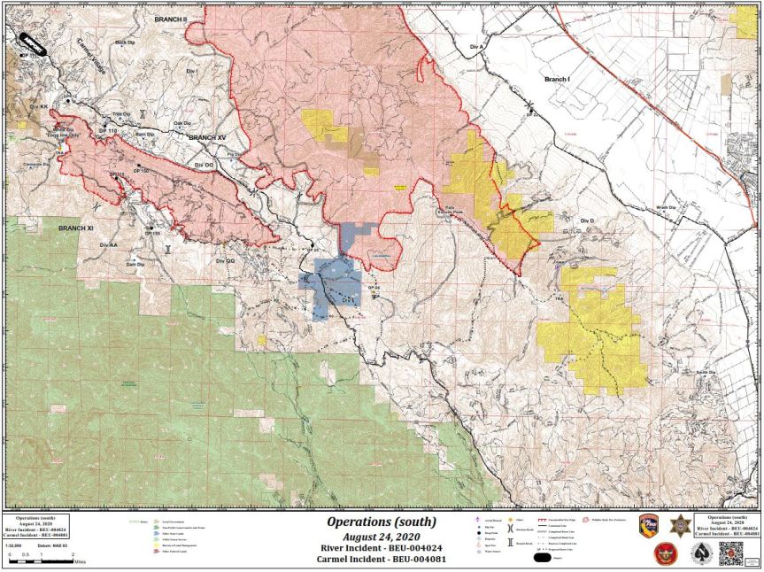
Today’s INCIDENT ACTION PLAN DETAILED MAPS
Operations Map North (click to open – large PDF file):

Operations Map South (click to open – large PDF file):
Evacuation Notifications here (note: select the DASHBOARD tab from a desktop computer for a detailed map with hot spots plus evacuation zones)
Evacuation Orders and Warnings Lifted for Zones 17, 18, 20, 21 and Portions of 19
Evacuation Warning – Zone 24 ( Arroyo Seco Rd, Campgrounds and Pine Canyon Rd, outside of KingCity)
Evacuation Order – R Zone 14 (River Road to Arroyo Seco)
Evacuation Warning – Zone 21 (West on Carmel Valley Road from Pinetree Lane to Rancho San Carlos)
Evacuation Order – Zones 19 (West of Carmel Valley Road between Klondike Canyon and Pinetree Lane)
Evacuation Order – Zone 17 and 18 (East of Carmel Valley Road to Laureless Grade and Highway 68)
Evacuation Map can be found here (Red is Order, Yellow is Warning)
Resources for Evacuees
Here is a list of all county evacuation shelters:
- Salinas Valley Fairgrounds, 625 Division Street, King City
- Carmel Middle School, 4380 Carmel Valley Rd, Carmel
- Sherwood Hall, 940 North Main Street, Salinas
- Monterey Conference Center, 1 Portola Plaza, Monterey
The County also has an evacuation center at the King City Library, 402 Broadway, which provides information and support, snacks, water and charging for devices for evacuee. It is open 8 am to 8 pm.
From SPCA: The SPCA is currently under an evacuation warning. We are safe, and we are here for you and your pets. We have been prepared for this for years. We are currently moving supplies and animals to the Monterey County Fairgrounds and Hitchcock Road Animal Services. We are doing this now so that we can continue our promise to always be here for you. (831) 373-2631
PIO Maps:


Related Links
- National Fire Situational Awareness (NFSA) Tool
- National Weather Service
- California Highway Patrol
- Monterey Country Sheriff’s Office
- Big Sur Land Trust
- Cal Trans Road Information
- California State Parks
- California Governors Office of Emergency Services
- Ventana Wilderness Alliance
- California Smoke Information Blog
- Monterey County Alerts
- Ready Set Go – Ready for Wildfire
- FAA Temporary Flight Restrictions
Incident Cooperators
- USDA Forest Service
- Big Sur Volunteer Fire Brigade
- California Department of Parks & Recreation
- California Department Of Transportation
- California Highway Patrol
- California State Office of Emergency Services
- Monterey County Sherriff
- National Weather Service
- USDA Forest Service, Los Padres National Forest
- Ventana Wilderness Alliance
For other information sources see:
- Office of Emergency Services response page here
- Quick reference of key resources to stay up-to-date here
- National interagency Fire Center Map can be found here
- Current Wind can be found here
- Alert Wildfire Camera here
- Scanner Fire & Sheriff
- Air Traffic here
- Road Closures here
- CalFire’s Ready, Set, Go! Checklist here (see page 9)
- Twitter links: #RiverFire and #CarmelFire
Important caveats: Please note that the squares on the heat detection maps represent the expected margin of error, not the size of the area burned. In other words, the detection could have come from anywhere within the square. Also be aware that false detections do sometimes occur. An outlying or “over the line” heat detection is not, by itself, a confirmation that there is fire in the area indicated. In addition, the satellites do not detect heat everywhere that fire exists. Creeping, backing or smoldering fire is often not detected. Finally, the detections are only snapshots of moments in time. Flare ups that occur before or after a satellite pass may be entirely missed.
Also be aware that yellow squares disappear from the map after 6 days. These are not maps of the area burned since the fire began, just maps of where heat has been detected during the past week.
Thank you!
That is some serious ‘bulldozer’ work. Nice job you guys- outstanding.