
Connie lives within walking distance of McWay Falls, within the closure area, and captured what might be the best photo of the Dolan Fire, but certainly the best photo taken today. Thanks Connie for letting me share it.


Connie lives within walking distance of McWay Falls, within the closure area, and captured what might be the best photo of the Dolan Fire, but certainly the best photo taken today. Thanks Connie for letting me share it.
Hermitage at 2 pm this afternoon;

New photos taken at 1:30 pm — show more fire cumulus clouds.


These are 45 minutes later. It has been making a run to the east for over two hours this afternoon.


12:30 pm — Not a cloud in the sky except for these shots over the Dolan Fire. The photos below were taken around 12:30 pm from my house at 3200’ on top of Plaskett Ridge. I sent them to the Dolan PIO who confirmed there was a slop over on the North Coast Road and it is now 200-300 acres and established. It is 1 mile east of Hot Springs Canyon. No structures are threatened. I will add more throughout the day if warranted. I have put these through HDR to bring out the contrasts which makes them easier to see.


9:30 pm — Here is the last update oF the evening. I’ll be back at it tomorrow morning.
August 24, 2020 8:00 PMPublic Information Phone: (831) 272-0222 Los Padres National Forest: www.fs.usda.gov/lpnf Facebook: facebook.com/lospadresnationalforestIncident E-mail: 2020.Dolan@firenet.govTwitter: twitter.com/LosPadresNFIncident Website: inciweb.nwcg.gov/incident/7018Big Sur FD: https://bigsurfire.org/
Incident Information:Start / Report Date: Aug. 18, 2020 Cause: Unknown
Fuels Involved: Chaparral, Brush, Timber understoryResources:Hand Crews: 11Engines: 46Dozers: 7 Size: 20,091
Location: Hwy 1(MM32.20) N of Limekiln State Park, 10 miles S of Big Sur
Helicopters: 4Fixed wing: 1Water Tenders: 7
Containment: 15%Injuries: 0Total Personnel: 662
Current Situation:Fire activity continued to be steady, with low intensity backing fire through the redwoods of Julia Pfeiffer Burns State Park. The fire was also active within the existing perimeter, reburning in areas the fire had previously passed through. The fire spotted over on the Eastern perimeter near the North Coast Ridge Road at the transition of the North Coast Ridge trail, with fire behavior and growth driven largely by fuels in an area with no recent fire history. Firefighters are monitoring fire growth in this area.
Crews continued to focus on the Northern and Southern edges of the fire by constructing and enhancing contingency lines. These handlines will provide additional protection and management options for firefighters in the event that fire progresses towards the structures. More dozer line was constructed to provide point protection for communities.
Fire behavior this evening is expected to be similar to previous nights, with activity picking up along the coast ridges during a five-hour window starting around midnight. Night operations will be focused on monitoring fire conditions, gathering critical intel that will assist the fire operations in the morning. Crews will also be monitoring bridges that may serve as pathways for fire to cross into unburned areas. The hazards of rolling rocks and spot fires in the field, as well as driving and traffic conditions on the road continue to be safety concerns for crews.
fAcreage reported here is an estimate and will be updated when IR images are available.
Carmel Fire Info: https://www.fire.ca.gov/incidents/2020/8/18/carmel-fire/ River Fire Info: https://www.fire.ca.gov/incidents/2020/8/16/river-fire/
Updates and Meetings: Fire Information is producing two daily written updates. To request an update, email 2020.dolan@firenet.gov and provide your email address. A daily video update will be posted to the Los Padres National Forest Facebook page and Inciweb (See links in header).
Weather: Tomorrow’s weather is expected to be typical for late summer days with a marine layer and inversion lifting to clear skies.
Evacuations / Closures: Click here for an interactive map of Monterey County evacuations.
Smoke: The Monterey Bay Air Resources District has issued a Wildfire Air Quality Advisory. When the concentration of smoke has reached UNHEALTHY levels of the AQI, residents should limit their activity by staying indoors with the doors and windows closed to avoid breathing smoke. Updates on the current air quality forecast and Air Monitoring data can be found at http://air.mbard.org/.
A!ert Monterey County: To receive emergency notifications regarding evacuations and critical events in Monterey County please sign up for A!ert Monterey County at the following website: https://member.everbridge.net/453003085611217/login.
Cooperating and Assisting Organizations: National Weather Service, California Highway Patrol, Monterey County Sheriff’s Department, Big Sur Volunteers, Cal Trans, California State Parks, OES, Ventana Wilderness Alliance
Safety Message: This will be a long duration event. Residents in the affected area are encouraged to continue to prepare for the possibility of fire in their area in advance. Go to https://www.ready.gov/wildfires to learn how to prepare.
Dolan Fire
California Interagency Incident Management Team 2
Public Information Phone: 831-272-0222
Incident E-mail: 2020.Dolan@firenet.gov
Incident Website: inciweb.nwcg.gov/incident/7018
As of last night: Dolan Fire – Acres: 19,287; Containment: 10%
8 am — I will be updating this page throughout the day, so click the title to open in a separate window, and refresh this page as you need. Please be patient with USFS, BSF, and Monterey County Sheriff as they release information about the status of the fire and the evacuation orders. (And with me as I gather it and post it). Thank you.
**Cancelled** Red Flag Warnings is still in effect through 5:00 p.m. Monday for dry lightning with gusty and erratic winds. Potential gusts as high as 65 mph can be expected with thunderstorms(North State Red Flag Warning still in effect).
DOLAN PUBLIC FIRE INFORMATION SOURCES:
Public Information Phone: (831) 272-0222
Incident E-mail: 2020.Dolan@firenet.gov
Incident Website: inciweb.nwcg.gov/incident/7018
This is the link for the county created interactive evacuations map for all three fires. You can enter an address and find out the status. Nice job MoCo! Thank you. https://www.co.monterey.ca.us/government/departments-a-h/administrative-office/office-of-emergency-services/response/2020-fires
For Carmel/River Fire, see Here
6:30 pm — John Chesnut send me a map of the “slop-over” on Coast Ridge Rd. That makes it clear. He thought it was an error until I told him what I had been watching it all day, and then what the PIO found out when I sent him a photo. This slop over is on Coast Ridge Road (aka North Coast Ridge Road and being erroneously referred to as “Mid-Coast Road” by the IMT members. I have notified the PIO, and they are changing how they refer to it. Here is the modis map done by that wonderful man I have never met. I have posted a lot of photos of what I watched today here: https://bigsurkate.blog/2020/08/24/dolan-fire-photos-fire-making-weather/

Additionally, there has been a lot of chatter re the Soberanes Footprint, so that wonderful man made me a map showing that Dolan is basically “skirting” Soberanes.

Beautiful blue skies and no smoke except by Lucia and Hermitage, the southern and south eastern section of the Dolan Fire.

John Chesnut’s Map:

August 24, 2020 8:00 AM
Public Information Phone: (831) 272-0222 Los Padres National Forest: www.fs.usda.gov/lpnfMedia Information Phone: (831) 272-0221 Facebook: facebook.com/lospadresnationalforestIncident E-mail: 2020.Dolan@firenet.govTwitter: twitter.com/LosPadresNFIncident Website: inciweb.nwcg.gov/incident/7018Big Sur FD: https://bigsurfire.org/
Incident Information:Start / Report Date: Aug. 18, 2020 Cause: UnknownFuels Involved: Chaparral, Brush, Timber understoryResources:Hand Crews: 9Engines: 42Dozers: 6
Size: 20,091Location: Hwy 1(MM32.20) N of Limekiln State Park, 10 miles S of Big Sur
Helicopters: 4Fixed wing: 1Water Tenders: 6
Containment: 10%Injuries: 0Total Personnel: 579
Current Situation:The Red Flag Warning has been cancelled for today.
The fire actively burned throughout the night. Fire activity moderated in the early morning hours as humidity increased. An Infrared flight was flown last night which contributed to the stated increase in acres, with an estimated growth of 500 acres.
Overnight crews were able to complete indirect handline around the communities of Lucia, Morning Glory, and Partington. These handlines will provide additional protection and management options for firefighters in the event that fire progresses towards the structures.
Today, crews will continue to focus on point protection on the North, West, and South ends of the fire. Crews will also be constructing indirect lines to support future containment operations. The hazard of rolling rocks and spot fires continue to be safety concerns for crews in all divisions, especially along Hwy 1.
Aerial resources will look to take advantage of clear skies when possible to assist ground resources with retardant and bucket drops. As air quality and visibility improve, aviation assets will support crews on the ground.
Yesterday, the Monterey County Sheriff’s Department entered into unified command with California Incident Management Team 2 and Big Sur Fire. The incident management team completed the move into a new incident command post at Pfeiffer Big Sur State Park.
Dolan Fire
California Interagency Incident Management Team 2
Public Information Phone: 831-272-0222
Incident E-mail: 2020.Dolan@firenet.gov
Incident Website: inciweb.nwcg.gov/incident/7018
Dolan Fire Update
August 24, 2020 8:00 AM
Public Information Phone: (831) 272-0222
Media Information Phone: (831) 272-0221 Incident E-mail: 2020.Dolan@firenet.gov
Incident Website: inciweb.nwcg.gov/incident/7018
Los Padres National Forest: http://www.fs.usda.gov/lpnf Facebook: facebook.com/lospadresnationalforest Twitter: twitter.com/LosPadresNF
Big Sur FD: https://bigsurfire.org/
Incident Information:
Start / Report Date: Aug. 18, 2020 Cause: Unknown
Fuels Involved: Chaparral, Brush, Timber understory
Resources:
Hand Crews: 9 Engines: 42 Dozers: 6
Current Situation:
Size: 20,091
Location: Hwy 1(MM32.20) N of Limekiln State Park, 10 miles S of Big Sur
Helicopters: 4 Fixed wing: 1 Water Tenders: 6
Containment: 10% Injuries: 0
Total Personnel: 579
The Red Flag Warning has been cancelled for today.
The fire actively burned throughout the night. Fire activity moderated in the early morning hours as humidity increased. An Infrared flight was flown last night which contributed to the stated increase in acres, with an estimated growth of 500 acres.
Overnight crews were able to complete indirect handline around the communities of Lucia, Morning Glory, and Partington. These handlines will provide additional protection and management options for firefighters in the event that fire progresses towards the structures.
Today, crews will continue to focus on point protection on the North, West, and South ends of the fire. Crews will also be constructing indirect lines to support future containment operations. The hazard of rolling rocks and spot fires continue to be safety concerns for crews in all divisions, especially along Hwy 1.
Aerial resources will look to take advantage of clear skies when possible to assist ground resources with retardant and bucket drops. As air quality and visibility improve, aviation assets will support crews on the ground.
Yesterday, the Monterey County Sheriff’s Department entered into unified command with California Incident Management Team 2 and Big Sur Fire. The incident management team completed the move into a new incident command post at Pfeiffer Big Sur State Park.
The fire is threatening the communities of Hermitage, Partington Ridge, and Lucia. Multiple businesses, communications sites, parks and recreational sites are also threatened. Among natural resources threatened are the Ventana Wilderness and coastal watershed and habitat for threatened and endangered species,
including the California condor.
Fire activity in the western United States has caused a high demand for fire personnel and equipment. The nation is in Preparedness Level 5 (PL5), the highest level. In PL5 over 80% of the nation’s incident management teams and wildland firefighting personnel are committed to incidents. Resource orders are being prioritized to fires across California and the west. Acreage reported here is an estimate and will be updated when IR images are available.
Carmel Fire Info: https://www.fire.ca.gov/incidents/2020/8/18/carmel-fire/ River Fire Info: https://www.fire.ca.gov/incidents/2020/8/16/river-fire/
Updates and Meetings: Fire Information is producing two daily written updates. To request an update, email 2020.dolan@firenet.gov and provide your email address. A daily video update will be posted to the Los Padres National Forest Facebook page and Inciweb (See links in header).
Weather: The Red Flag Warning has been cancelled for today. The weather is expected to be partly to mostly cloudy, with winds of 5-12 miles per hour with gusts of 20 miles per hour on the ridgetops.
Evacuations / Closures: Click here for an interactive map of Monterey County evacuations.
Smoke: The Monterey Bay Air Resources District has issued a Wildfire Air Quality Advisory. When the concentration of smoke has reached UNHEALTHY levels of the AQI, residents should limit their activity by staying indoors with the doors and windows closed to avoid breathing smoke. Updates on the current air quality forecast and Air Monitoring data can be found at http://air.mbard.org/.
A!ert Monterey County: To receive emergency notifications regarding evacuations and critical events in Monterey County please sign up for A!ert Monterey County at the following website: https://member.everbridge.net/453003085611217/login.
Cooperating and Assisting Organizations: National Weather Service, California Highway Patrol, Monterey County Sheriff’s Department, Big Sur Volunteers, Cal Trans, California State Parks, OES, Ventana Wilderness Alliance
Safety Message: This will be a long duration event. Residents in the affected area are encouraged to continue to prepare for the possibility of fire in their area in advance. Go to https://www.ready.gov/wildfires to learn how to prepare.
Carmel Fire (Day 7) and River Fire (Day 9) post. Click the title to open in a separate window, and refresh this page throughout the day. Please be patient with CalFire and Monterey County Sheriff as they release information about the status of the fires and the evacuation orders. Thank you.
CAL FIRE NEWS RELEASE
California Department of Forestry and Fire Protection
Media Line: 831-647-6257 Release Date: August 24, 2020 Public Information: 925-532-5455 Time: 1:00 P.M.
RIVER AND CARMEL FIRES REPOPULATION
WHAT: Evacuation Orders and Evacuation Warnings Lifted on the River and Carmel Fires DATE/TIME: August 24, 2020 at 1:00 P.M.
WHERE: Areas of repopulation in the following zones
EVACUATION ORDERS LIFTED:
• Zone 1: Pine Canyon Rd, Parker Rd, Laurel Ln, and Trimble Hill Ln. EXCEPTION:
Pine Canyon Rd west of Mesa REMAIN UNDER EVACUATION ORDER
• Zone 2: South of River Rd from Tara Dr to Pine Canyon Rd to include all roads off Las Palmas Pkwy, Ranchito Dr, Indian Springs Rd, Redding Dr, and Belmont Circle. EXCEPTION:
Berry Dr west of Enos Dr REMAIN UNDER EVACUATION ORDER.
• Zone 4: Southwest of Parker Rd, northwest of Corral De Cielo Rd, and Rana Creek. Southeast of the intersection of Chualar River Rd and River Rd, northwest of Limekiln.
• Zone 5: Harper Canyon area, all areas within north of San Benancio Rd, west of Troy Ln, southeast of Harper Canyon Rd, to include Harper Canyon Road, Weather Rock Way, and Rimrock Canyon Rd.
• Zone 6: West of River Rd from Parker Rd, South to Limekiln Rd to include Limekiln Rd.
• Zone 8: All areas south of Highway 68, east of San Benancio Rd to include San Benancio Rd south to Harper Canyon Rd
• Zone 10: All areas south within the intersection of Hwy 68 and River Road to Tara Drive and Hwy 68 south to San Benancio Road, including the Los Palmas 1 and 117 Drive Communities. This order does not include the Toro Regional Main Park area.
EVACUATION WARNINGS LIFTED:
• Zone 3: Indian Canyon, Mt. Toto Access Rd and San Benancio Rd from Troy Ln to
Corral de Tierra, including Corral del Cielo Rd, Lucie Ln, and Covie Ln.
• Zone 9,11: Areas North of Highway 68 from Portola Drive and Veronica Drive/Estoque Place east, to include all roads off Portola Drive to Creekside Court.
THERE WILL BE ROAD CLOSURES AT:
• Pine Canyon Rd at Mesa Rd • Berry Dr at Enos Dr
To view the River and Carmel Fires Evacuation Map please visit:
https://www.co.monterey.ca.us/government/departments-a-h/administrative-office/office-of- emergency-services/situational-awareness/public-alert-warning
SAFETY MESSAGE: The public is reminded to stay vigilant on current fire conditions. Please continue to adhere to road closures and evacuation orders or warnings. If you see electrical wires on the ground, stay clear and contact PG&E immediately. For those who may be utilizing backup generators, please review the generator use safety information at https://www.pge.com/en_US/safety/electrical-safety/electric-generator-safety/electric-generator- safety.page?WT.pgeac=PSPS_FAQ-GeneratorSafety. Trees and poles with deep charring, particularly if still smoldering, should be considered hazardous. Please drive slowly and yield to emergency personnel in the area.
Please visit http://www.co.monterey.ca.us/government/departments-a-h/health for public health or https://www.co.monterey.ca.us/government/departments-a-h/health/behavioral-health for behavioral health concerns.
For additional information on the River and Carmel Fires, Monterey County residents should contact River and Carmel Fires Information Line at (831) 647-6257or 211. To sign up for emergency alert notifications visit: http://www.alertmontereycounty.org
For more information on wildfire, visit CAL FIRE online at http://www.readyforwildfire.org ###
Evacuation Orders and Warnings Lifted for Zones 17, 18, 20, 21 and Portions of 19
The Evacuation Orders and Warnings covering the areas of Carmel Valley, Corral de Tierra, and San Benancio are being lifted effective at 9:00am on Monday, August 24, 2020. This covers the entirety of evacuation order Zones 17, and 18 and the northern portion of Zone 19. The Evacuation Warnings in Zone 20 and 21 are also being lifted. The southern portion of Zone 19 from the intersection of Esquiline Rd. at Carmel Valley Rd remains under an Evacuation Order. As Esquiline Rd travels south, it becomes Southbank Rd. which becomes Hitchcock Rd and will form the northern boundary of the current evacuation order. (click image to open map, please see additional Warnings/Orders below)


**Cancelled** Red Flag Warnings is still in effect through 5:00 p.m. Monday for dry lightning with gusty and erratic winds. Potential gusts as high as 65 mph can be expected with thunderstorms (North State Red Flag Warning still in effect). Still, a threat of pop-up thunderstorms, and somewhat of a lighting threat. Big terrain-driven “swirly” winds on the River Fire. Westerly influenced winds on the Carmel Fire. Temperatures are the same as yesterday, humidity is up.
CalFire Incident page Carmel & River CalFire Facebook Updates here. Sheriff Facebook Updates here. Monterey County Office of Emergency Services Facebook here
7AM CalFire Incident Briefing (video starts at 4:40, see detailed Day Operations Plan at 12:00, please note the date is incorrect on the title):
River: 48,424 acres, 23% contained, 1,274 personnel assigned, 8 residences damaged, 8 residences destroyed, 1 minor structure damaged, and 13 minor structures destroyed, damage inspection is 50% complete, delivered 305,000 gallons of water and over 281,000 gallons of fire retardant.
Carmel: 6,695 acres 15% contained, 909 personnel assigned, 5 residences damaged, 35 residences destroyed, 16 minor structures damaged, 2 minor structures destroyed, damage inspection 54% complete, delivered over 197,000 gallons of water and over 9,000 gallons of fire retardant.
Dolan: as of 8PM, 19,287 acres, 10% contained, 579 personnel.
“Facts to know: In 2019 we only had 13,000 acres burned in all of California. As of 2020, we’ve had over 500,000 acres burned, so these are unprecedented times.” -Unified Incident Commander
“…these fires are in very sensitive archaeology rich area, in particular, the Carmel Fire … we’ve already have a few sites that have gotten hit … if you see this (special zone flagging) if at all possible, keep the equipment out of there.” -CalFire Archaeologist
9:45 AM: Carmel and River Fires Google Earth Image with VIIRS and MODIS Satellite and CDF Infrared Outline (white line from 08/20/20). The Latest satellite heat detection spots are from 3:24 AM PM. (please see Important Caveat note at the bottom of this post)
Click this link to view larger image: Carmel_River_Fire2_082420


Fire Break looking down Osborne Ridge towards Buck Mountain at 6:15 PM, Sunday evening (8/23/20):

Fire Break looking up Osborne Ridge at 6:15 PM, Sunday evening (8/24/20):

Bulldozers working “on top of the ridge above the ballpark”, at 10PM, Sunday evening (8/23/20):

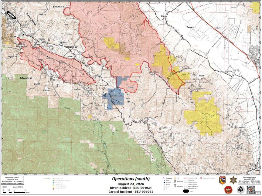
Today’s INCIDENT ACTION PLAN DETAILED MAPS
Operations Map North (click to open – large PDF file):

Operations Map South (click to open – large PDF file):
Evacuation Notifications here (note: select the DASHBOARD tab from a desktop computer for a detailed map with hot spots plus evacuation zones)
Evacuation Orders and Warnings Lifted for Zones 17, 18, 20, 21 and Portions of 19
Evacuation Warning – Zone 24 ( Arroyo Seco Rd, Campgrounds and Pine Canyon Rd, outside of KingCity)
Evacuation Order – R Zone 14 (River Road to Arroyo Seco)
Evacuation Warning – Zone 21 (West on Carmel Valley Road from Pinetree Lane to Rancho San Carlos)
Evacuation Order – Zones 19 (West of Carmel Valley Road between Klondike Canyon and Pinetree Lane)
Evacuation Order – Zone 17 and 18 (East of Carmel Valley Road to Laureless Grade and Highway 68)
Evacuation Map can be found here (Red is Order, Yellow is Warning)
Resources for Evacuees
Here is a list of all county evacuation shelters:
The County also has an evacuation center at the King City Library, 402 Broadway, which provides information and support, snacks, water and charging for devices for evacuee. It is open 8 am to 8 pm.
From SPCA: The SPCA is currently under an evacuation warning. We are safe, and we are here for you and your pets. We have been prepared for this for years. We are currently moving supplies and animals to the Monterey County Fairgrounds and Hitchcock Road Animal Services. We are doing this now so that we can continue our promise to always be here for you. (831) 373-2631
PIO Maps:


For other information sources see:
Important caveats: Please note that the squares on the heat detection maps represent the expected margin of error, not the size of the area burned. In other words, the detection could have come from anywhere within the square. Also be aware that false detections do sometimes occur. An outlying or “over the line” heat detection is not, by itself, a confirmation that there is fire in the area indicated. In addition, the satellites do not detect heat everywhere that fire exists. Creeping, backing or smoldering fire is often not detected. Finally, the detections are only snapshots of moments in time. Flare ups that occur before or after a satellite pass may be entirely missed.
Also be aware that yellow squares disappear from the map after 6 days. These are not maps of the area burned since the fire began, just maps of where heat has been detected during the past week.