Catching some zzzs at Plaskett Creek campgrounSand Dollar BeachAnother dozer for the causeFirst sign of fire, middle ridge in this photoCHP John and USFS PIO Anna, holding down the fort at LuciaHermitage Driveway stagingLooks like a spike camp getting set up, NW of PV Station – helicopter fuel truck on left. US Food truck at Pv Station across the road and down a bit.Look PMC! We brought our own porta potties!!!
And that is how the afternoon of Saturday, August 22 looked on the south coast. When we left to go to Cambria, we passed many, many cars heading UP the coast, but coming back, we were one of the few going north. Very few cars stopped on the side of the road after getting into the closed area at Ragged Point. There was no one lined up at any of the road blocks we drove around. Limekiln, Kirk Creek, Plaskett Creek all closed. The north coast, I am hearing is a different story and that Sycamore Canyon and Pfeiffer Beach were a nightmare for residents. Our dirt roads are still a mess, but fortunately, not being made more so.
6:30 pm — I am posting this at 6:30 pm, my first available opportunity today, but not sure when released. Note the fire has increased to 14,000 acres, but 10% containment.
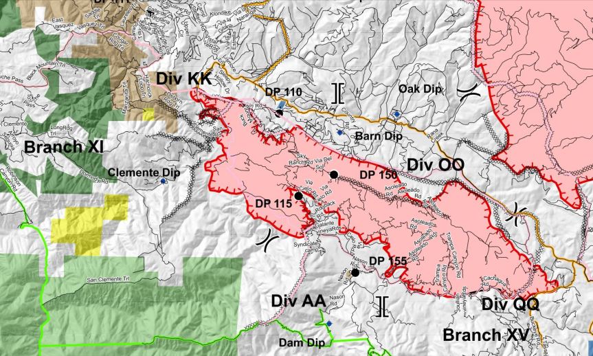
Overnight point protection continued to be the focus of operations. Point protection refers to the preparation and defense of structures or other values in the fire’s path of spread. The three priorities for point protection are Hermitage, Partington Ridge and Anderson Peak communications infrastructure. As the threat diminishes and fire passes, these priorities will shift. As more resources arrive the operation will expand to include additional perimeter control operations.
Hot Shot crews are working on perimeter control on the north end of the fire off North Coast Ridge Road, where the fire had burned over the road, these firefighters are building fire line directly on the fire’s edge to prevent the possibility of further spread. Containment along the west side of the fire (10% so far) is expected to increase over the next few days as firefighters assure that the line is secure.
The fire remained active in the areas Hermitage and Lucia, along Highway 1, overnight. The fire spread slowly as fire backed down slope.
Today, operations will continue to focus on point protection and scouting for locations to build direct and indirect fire line. Fire spread will be mainly to the south, laterally along the coast ridge. Smoke from other fires in the area is shading the Dolan Fire. Though the smoke makes it difficult to locate the exact perimeter of the fire, it has the benefit of decreasing the direct sunlight and dampening fire behavior. In areas above the layer of smoke, or when the smoke lifts, fire behavior will become more active. As Tropical Depression Genevieve moves into the area, unstable air will likely lift the smoke layer and result in more active fire behavior.
The fire is threatening the communities of Hermitage, Partington Ridge, and Lucia. Multiple businesses, communications sites, parks and recreational sites are also threatened. Among natural resources threatened are the Ventana Wilderness and coastal watershed and habitat for threatened and endangered species, including the California condor.
Fire activity in the western United States has caused a high demand for fire personnel and equipment. The nation is in Preparedness Level 5 (PL5), the highest level. In PL5 over 80% of the nation’s incident management teams and wildland firefighting personnel are committed to incidents. Resource orders are being prioritized to fires across California and the west. Aircraft that can map a fire using infrared imagery used to determine acreage have not yet flown the fire. Acreage reported here is an estimate and will be updated when IR images are available.
Updates and Meetings: Fire Information is producing two daily written updates. To request an update, email 2020.dolan@firenet.gov and provide your email address. A daily video update will be posted to the Los Padres National Forest Facebook page and Inciweb (See links in header). Additionally, a live online community meeting will be held on the Los Padres National Forest Facebook page today at 2:00 p.m.
Weather: Moisture from Tropical Depression Genevieve will bring mostly cloudy skies and cooler temperatures to the area today. A Fire Weather Watch has been issued from Sunday at 11:00 a.m. through Tuesday at 11:00 a.m. due to a potential for Thunderstorms.
Evacuations / Closures: Click here for an interactive map of Monterey County evacuations.
The closure of Highway 1 has changed. The highway is now closed near mile marker 38/Troy (Torre) Canyon on the north and Hermitage on the south.
Smoke: The Monterey Bay Air Resources District has issued a Wildfire Air Quality Advisory. When the concentration of smoke has reached UNHEALTHY levels of the AQI, residents should limit their activity by staying indoors with the doors and windows closed to avoid breathing smoke. Updates on the current air quality forecast and Air Monitoring data can be found at http://air.mbard.org/.
Alert Monterey County: To receive emergency notifications regarding evacuations and critical events in Monterey County please sign up for A!ert Monterey County at the following website.
Safety Message: Area residents are encouraged to prepare for the approach of fire in advance. Go to https://www.ready.gov/wildfires to learn how to prepare.
Incident Information
Basic Information
Current as of
8/22/2020, 10:34:29 AM
Incident Type
Wildfire
Cause
Unknown
Date of Origin
Tuesday August 18th, 2020 approx. 08:15 PM
Location
Highway 1(MM 32.20) North of Limekiln State Park, 10 miles South of Big Sur
Incident Commander
Mike Minton, CA IMT Team 2 in unified command with Big Sur Fire
Incident Description
Wildfire
Coordinates
36.123 latitude, -121.602 longitude
Current Situation
Total Personnel
400
Size
14,000 Acres
Percent of Perimeter Contained
10%
Estimated Containment Date
Wednesday September 02nd, 2020 approx. 12:00 AM
Fuels Involved
Chaparral (6 feet)Brush (2 feet)Timber (Grass and Understory)
Significant Events
ActiveFlankingGroup Torching
Outlook
Planned Actions
Crews in all divisions will continue to verify location, scout for opportunities to construct direct/indirect control lines, and evaluate need for point protection and structure defense.
Projected Incident Activity
Fire will continue to burn in the Ventana Wilderness. Fire is taking advantage of slope driven runs and dry fuel, moving up and down canyons, spotting and making erratic runs, fire movement in all directions, ie. west, south, north, and east. Area tends to burn actively in the evening hours driven by mid slope thermal weather activity. Concern that the smoke inversion will lift and the fire activity will increase.
Current Weather
Weather Concerns
Moisture from Tropical Depression Genevieve will bring mostly cloudy skies and cooler temperatures to the area today. A Fire Weather Watch has been issued from Sunday at 11:00 a.m. through Tuesday at 11:00 a.m. due to a potential for Thunderstorms.
5 PM — I know things have been scattered here today, because I was trying to take the day off, to get away from the heat and smoke, and the stress. So I went to town. Most of you understand. I posted a couple things I thought were important, but because I was on my tiny iPhone, I couldn’t explain what I was doing. I will be back within the hour to bring things up to date and organize as best I can, but I have to put the groceries away, feed the dogs, water the plants, and other wise take care of life. Going down the mountain to do a supply run allowed me first hand views of what is going on here on the south end of the fire. Be patient.
BAD NEWS
GOOD NEWS —
`12:45 — Good inews the National Guard is being mobilized to come to help CA as of 10 AM. The NIFC — National Interagency Fire Center is mobilizing.
On a personal note, I am taking a day to cool off and breathe some hopefully cleaner air today, so I will be on and off as signal and circumstances provide.
I will remind people that the way John does his maps is that each day is outlined. Day 1 is a small octogon shape in white barely visible anymore, Day 2 is in green, Day 3 is in red, day 4 is yellow and today has just begun.
From the deck of the Redwood School last night by David Halterman
Carmel (Day 5) and River (Day 7) are combined into one post. Click the title to open a separate window, refresh this page throughout the day. Stay safe and smart. Please maintain situational awareness at all times.
Scroll down for “unofficial” satellite imagery updated 7:30PM. A Red Flag Warning was issued for Sunday 5AM to Monday 5PM.
EVACUATION ORDER FOR HIGHWAY 68 AREAS, CARMEL VALLEY VILLAGE, ARROYO SECO AREAS, ETC.:
Evacuation Shelters:
The Monterey Conference Center, 1 Portola Plaza, Monterey
Carmel Middle School, 4380 Carmel Valley Road, Carmel
Sherwood Hall, 940 North Main Street, Salinas
Evacuation Center
King City Library, 402 Broadway, King City. Open 8 am to 8 pm.
From SPCA: The SPCA is currently under an evacuation warning. We are safe, and we are here for you and your pets. We have been prepared for this for years. We are currently moving supplies and animals to the Monterey County Fairgrounds and Hitchcock Road Animal Services. We are doing this now so that we can continue our promise to always be here for you.
Due to fire activity on the southern end of the River Fire, the Monterey County Sheriff’s Office has issued an Evacuation Warning for Zone 24 which include all areas South of the intersection of East Carmel Valley Road and Arroyo Seco Road to the intersection of Arroyo Seco Road and Elm Avenue, to the intersection of Elm Avenue and Central Avenue. All areas West of the intersections of Elm Avenue and Central Avenue south to the intersection of Central Avenue and Highway 101 to the intersection of Highway 101 and Jolon Road to the intersection of Jolon Road and San Lucas Road. All areas North from the intersection of Jolon Road and San Lucas Road to Junipero Serra Peak. All areas East of Junipero Serra Peak to East Carmel Valley Road. To include the communities from the Green Bridge west to the end of Arroyo Seco Rd. To inlcude Arroyo Seco Rd, the Gorge, Millers Lodge, Freds Camp, Sycamore Flats, and Pine Canyon Rd outside of King City. The Evacuation Warning for Zone 24 includes the Arroyo Seco Resort and Recreation Site/Campgrounds; The map has been updated to reflect this inclusion. The Pine Canyon Road referenced in the areas east of Junipero Serra Peak is outside of King City.
The Monterey County Sheriff’s Office has issued an Evacuation Order R Zone 14 which includes all areas east of Carmel Valley Road extending south from finch Creek to Arroyo Seco Rd. All areas west of River Road and Fort Romie Road and Arroyo Seco Road extending South to Elm Avenue and Arroyo Seco Rd.
The Monterey County Sheriff’s Office has issued an Evacuation Warning for Zone 21 which includes areas west on Carmel Valley Road from Pinetree Lane to Rancho San Carlos. This warning includes all communities south of Carmel Valley Road to include Carmel Valley Road, Rancho San Carlos and all tributary roads.
The Monterey County Sheriff’s Office has issued an Evacuation Warning for Zone 20 which includes all areas and roads south of Highway 68 from Laureles Grade Road extending west to York Road/Camino Saucito and extending south to Carmel Valley Road. All areas and roads north of Carmel Valley Road from Laureles Grade Road extending west to Schetter Road.
The Monterey County Sheriff’s Office has issued an Evacuation Order for Zone 19 including areas west of Carmel Valley Road from Klondike Canyon Road to Pine Tree Lane extending south to Dormody Road and east to Hitchcock Canyon Road and San Clemente Drive. The Evacuation Order includes all communities of Carmel Valley Road between Klondike Canyon and Pine Tree Lane, including Carmel Valley Village and Robles Del Rio. Leave the area.
Zone 17: All areas south of Highway 68 from San Benancio Road to Laureles Grade. To include all roads east of Laureles Grade at La Rancheria Rd to the south, and all areas west of San Benancio Road. EVACUATION ORDER
Zone 18: From Klondike Canyon Road to Laureles Grade, North on Laureles Grade from Carmel Valley Road to La Rancheria. Includes all communities North East of Carmel Valley Road, and all communities East of Laureles Grade to include Carmel Valley Road, Laureles Grade, La Rancheria and all tributary roads. EVACUATION ORDER
Evacuation Notifications can be found here (note: select the DASHBOARD tab from a desktop computer for a detailed map with hot spots plus evacuation zones)
Evacuation Map can be found here (Red is Order, Yellow is Warning)
Carmel Fire Incident Update 7 PM:
River Fire Incident Update 7 PM:
The greatest threat for elevated thunderstorms will be from Sunday night into Monday morning. Lightning and gusty winds have the potential to produce new fire starts. Now is the time to prepare if a fire starts near you. Visit http://readyforwildfire.org for more info. #CaWx
7:30 PM: Carmel and River Fires Google Earth Image with VIIRS and MODIS Satellite and CDF Infrared Outline (white line from 08/20/20). The Latest satellite heat detection spots are from 2:30 PM PT (please see Important Caveat note at the bottom of this post, false detections do sometimes occur, satellites do not detect heat everywhere that fire exists, the detections are only snapshots of moments in time). Also, as a reminder, these images are not official information.
7:00 AM: Carmel and River Fires Google Earth Image with VIIRS and MODIS Satellite and CDF Infrared Outline (orange line from 08/20/20). The Latest satellite heat detection spots are from 4:00 AM PT (please see Important Caveat note at the bottom of this post)
Important caveats: Please note that the squares on the heat detection maps represent the expected margin of error, not the size of the area burned. In other words, the detection could have come from anywhere within the square. Also be aware that false detections do sometimes occur. An outlying or “over the line” heat detection is not, by itself, a confirmation that there is fire in the area indicated. In addition, the satellites do not detect heat everywhere that fire exists. Creeping, backing or smoldering fire is often not detected. Finally, the detections are only snapshots of moments in time. Flare ups that occur before or after a satellite pass may be entirely missed.
Also be aware that yellow squares disappear from the map after 6 days. These are not maps of the area burned since the fire began, just maps of where heat has been detected during the past week.


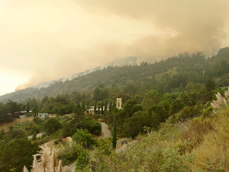


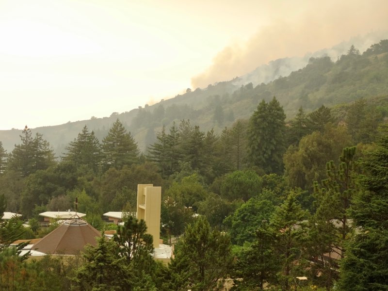


 Image options: [


")


