

Carmel (Day 5) and River (Day 7) are combined into one post. Click the title to open a separate window, refresh this page throughout the day. Stay safe and smart. Please maintain situational awareness at all times.
Scroll down for “unofficial” satellite imagery updated 7:30PM. A Red Flag Warning was issued for Sunday 5AM to Monday 5PM.
CalFire Incident page Carmel & River CalFire Facebook Updates here. Sheriff Facebook Updates here.
EVACUATION ORDER FOR HIGHWAY 68 AREAS, CARMEL VALLEY VILLAGE, ARROYO SECO AREAS, ETC.:
Evacuation Shelters:
- The Monterey Conference Center, 1 Portola Plaza, Monterey
- Carmel Middle School, 4380 Carmel Valley Road, Carmel
- Sherwood Hall, 940 North Main Street, Salinas
- Evacuation Center
- King City Library, 402 Broadway, King City. Open 8 am to 8 pm.
From SPCA: The SPCA is currently under an evacuation warning. We are safe, and we are here for you and your pets. We have been prepared for this for years. We are currently moving supplies and animals to the Monterey County Fairgrounds and Hitchcock Road Animal Services. We are doing this now so that we can continue our promise to always be here for you.
Evacuation Warning – Zone 24 ( Arroyo Seco Rd, Campgrounds and Pine Canyon Rd, outside of King City) 8:52 PM
Due to fire activity on the southern end of the River Fire, the Monterey County Sheriff’s Office has issued an Evacuation Warning for Zone 24 which include all areas South of the intersection of East Carmel Valley Road and Arroyo Seco Road to the intersection of Arroyo Seco Road and Elm Avenue, to the intersection of Elm Avenue and Central Avenue. All areas West of the intersections of Elm Avenue and Central Avenue south to the intersection of Central Avenue and Highway 101 to the intersection of Highway 101 and Jolon Road to the intersection of Jolon Road and San Lucas Road. All areas North from the intersection of Jolon Road and San Lucas Road to Junipero Serra Peak. All areas East of Junipero Serra Peak to East Carmel Valley Road. To include the communities from the Green Bridge west to the end of Arroyo Seco Rd. To inlcude Arroyo Seco Rd, the Gorge, Millers Lodge, Freds Camp, Sycamore Flats, and Pine Canyon Rd outside of King City. The Evacuation Warning for Zone 24 includes the Arroyo Seco Resort and Recreation Site/Campgrounds; The map has been updated to reflect this inclusion. The Pine Canyon Road referenced in the areas east of Junipero Serra Peak is outside of King City.
Evacuation Order – R Zone 14 (River Road to Arroyo Seco) 5:00 PM
The Monterey County Sheriff’s Office has issued an Evacuation Order R Zone 14 which includes all areas east of Carmel Valley Road extending south from finch Creek to Arroyo Seco Rd. All areas west of River Road and Fort Romie Road and Arroyo Seco Road extending South to Elm Avenue and Arroyo Seco Rd.
Evacuation Warning – Zone 21 (West on Carmel Valley Road from Pinetree Lane to Rancho San Carlos) 10:03 AM
The Monterey County Sheriff’s Office has issued an Evacuation Warning for Zone 21 which includes areas west on Carmel Valley Road from Pinetree Lane to Rancho San Carlos. This warning includes all communities south of Carmel Valley Road to include Carmel Valley Road, Rancho San Carlos and all tributary roads.
Evacuation Warning – Zone 20 9:55 AM:
The Monterey County Sheriff’s Office has issued an Evacuation Warning for Zone 20 which includes all areas and roads south of Highway 68 from Laureles Grade Road extending west to York Road/Camino Saucito and extending south to Carmel Valley Road. All areas and roads north of Carmel Valley Road from Laureles Grade Road extending west to Schetter Road.
Evacuation Order – Zones 19 (West of Carmel Valley Road between Klondike Canyon and Pinetree Lane) 9:01 AM
The Monterey County Sheriff’s Office has issued an Evacuation Order for Zone 19 including areas west of Carmel Valley Road from Klondike Canyon Road to Pine Tree Lane extending south to Dormody Road and east to Hitchcock Canyon Road and San Clemente Drive. The Evacuation Order includes all communities of Carmel Valley Road between Klondike Canyon and Pine Tree Lane, including Carmel Valley Village and Robles Del Rio. Leave the area.
Evacuation Order – Zone 17 and 18 (East of Carmel Valley Road to Laureless Grade and Highway 68) 9:00 AM
Zone 17: All areas south of Highway 68 from San Benancio Road to Laureles Grade. To include all roads east of Laureles Grade at La Rancheria Rd to the south, and all areas west of San Benancio Road. EVACUATION ORDER
Zone 18: From Klondike Canyon Road to Laureles Grade, North on Laureles Grade from Carmel Valley Road to La Rancheria. Includes all communities North East of Carmel Valley Road, and all communities East of Laureles Grade to include Carmel Valley Road, Laureles Grade, La Rancheria and all tributary roads. EVACUATION ORDER
Evacuation Notifications can be found here (note: select the DASHBOARD tab from a desktop computer for a detailed map with hot spots plus evacuation zones)
Evacuation Map can be found here (Red is Order, Yellow is Warning)

Carmel Fire Incident Update 7 PM:


River Fire Incident Update 7 PM:


The greatest threat for elevated thunderstorms will be from Sunday night into Monday morning. Lightning and gusty winds have the potential to produce new fire starts. Now is the time to prepare if a fire starts near you. Visit http://readyforwildfire.org for more info. #CaWx

Weather Watch in effect:

Contingency Map (large PDF file with current CalFire contingency lines): Contingency_36x48_Land_20200821_0447
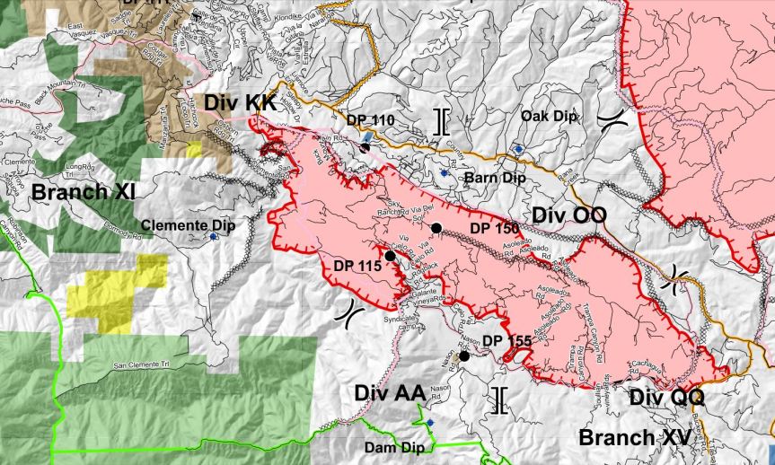
PIO Map: PIO 112×17 8-22


")


7:30 PM: Carmel and River Fires Google Earth Image with VIIRS and MODIS Satellite and CDF Infrared Outline (white line from 08/20/20). The Latest satellite heat detection spots are from 2:30 PM PT (please see Important Caveat note at the bottom of this post, false detections do sometimes occur, satellites do not detect heat everywhere that fire exists, the detections are only snapshots of moments in time). Also, as a reminder, these images are not official information.
Click this link to view larger image: Carmel_River_Fire4_082220

Click this link to view larger image: Carmel_River_Fire_Escrito4_082220

7:00 AM: Carmel and River Fires Google Earth Image with VIIRS and MODIS Satellite and CDF Infrared Outline (orange line from 08/20/20). The Latest satellite heat detection spots are from 4:00 AM PT (please see Important Caveat note at the bottom of this post)
Click this link to view larger image: Carmel_River_Fire3_082220

Palo Escrito View: Carmel_River_Fire_Escrito3_082220

Maps by John Chesnut: Carmel Morning 8_22


Friday Evening update:
Related Links
- National Fire Situational Awareness (NFSA) Tool
- National Weather Service
- California Highway Patrol
- Monterey Country Sheriff’s Office
- Big Sur Land Trust
- Cal Trans Road Information
- California State Parks
- California Governors Office of Emergency Services
- Ventana Wilderness Alliance
- California Smoke Information Blog
- Monterey County Alerts
- Ready Set Go – Ready for Wildfire
- FAA Temporary Flight Restrictions
Incident Cooperators
- USDA Forest Service
- Big Sur Volunteer Fire Brigade
- California Department of Parks & Recreation
- California Department Of Transportation
- California Highway Patrol
- California State Office of Emergency Services
- Monterey County Sherriff
- National Weather Service
- USDA Forest Service, Los Padres National Forest
- Ventana Wilderness Alliance
For other information sources see:
- Office of Emergency Services response page here
- Quick reference of key resources to stay up-to-date here
- National interagency Fire Center Map can be found here
- Current Wind can be found here
- Alert Wildfire Camera here
- Scanner Fire & Sheriff
- Air Traffic here
- Road Closures here
- CalFire’s Ready, Set, Go! Checklist here (see page 9)
- Twitter links: #RiverFire and #CarmelFire
Important caveats: Please note that the squares on the heat detection maps represent the expected margin of error, not the size of the area burned. In other words, the detection could have come from anywhere within the square. Also be aware that false detections do sometimes occur. An outlying or “over the line” heat detection is not, by itself, a confirmation that there is fire in the area indicated. In addition, the satellites do not detect heat everywhere that fire exists. Creeping, backing or smoldering fire is often not detected. Finally, the detections are only snapshots of moments in time. Flare ups that occur before or after a satellite pass may be entirely missed.
Also be aware that yellow squares disappear from the map after 6 days. These are not maps of the area burned since the fire began, just maps of where heat has been detected during the past week.
I’m sure you hear this a lot but it’ll never be enough: Thank You!. I rely on your information. None of my alerts (Monterey Alert) have worked yet and local groups in Carmel Valley do not have reliable information, mostly gossip. I see the attention, time and effort you put into this. The inclusion of official information is priceless. You are a local hero and loved my many.
Yes thank you for putting this information all together in one place!!! Jacki