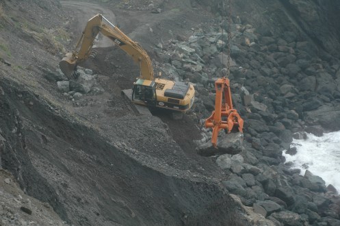
Highway One Repair at Big Sur River

Debbie Reed so kindly sent me the following photos so all my interested readers can see the repair work going on to shore up the bank of the river to prevent undermining Highway One. Thanks, Debbie! You are the best!

And there you have it, and after all the hoopla, Cal-Trans and PG&E were able to work it out, move the polls (that should be “poles” — thanks, Simon), and not make everyone go without electricity for 8 hours a day for two weeks! Where there is a will … or a lot of screaming customers!

Storm Watch, 2/2/10

I knew we were in for 6 more weeks of winter, and even wrote that on my Modern Homesteader page, but now that is confirmed:
www.huffingtonpost.com
Most local groundhogs did not see their shadows on Groundhog Day 2010, even though the most famous one of all did. Punxsutawney Phil’s Groundhog Day 2010 prediction was six more weeks of winter, as he did see his shadow.

Sprinkles last night around 5:15 pm, but didn’t amount to much. Just enough to need to cover the gennie. And despite the forecast below, it doesn’t look like rain up here today. Scattered high clouds and sunshine is what I see.

NOAA forecast discussion: “AS OF 9 AM PST TUESDAY…WITH DAYTIME HEATING COMMENCING…SCATTERED SHOWERS ARE DEVELOPING ALONG AN AREA FROM SW OF MONTEREY BAY NORTHEAST THROUGH PITTSBURG…. OTHERWISE…EXPECT THESE SHOWERS TO REMAIN FOR MUCH OF TODAY AND TONIGHT WITH THE UPPER LEVEL TROUGH MOVING OVERHEAD TODAY AND TONIGHT. PRECIP IS STILL FORECAST TO DIMINISH ON WEDNESDAY AS THE UPPER LEVEL TROUGH MOVES EAST.

AS OF NOW…THE REST OF THE FORECAST LOOKS GOOD. THE NEXT MAJOR WEATHER MAKER MOVES IN THURSDAY AND CONTINUES THROUGH EARLY SATURDAY. A GOOD SOAKING RAIN LOOKS POSSIBLE.

Storm Watch, 1/30/10

Received almost 1/2 inch last night, bringing the season’s total to 41.35 inches.

NOAA discussion: “AS OF 3:45 AM PST SATURDAY…UNSETTLED WEATHER IS IN STORE FOR THE UPCOMING WORK WEEK….WITH THE BEST CHANCE OF SIGNIFICANT RAIN LATE IN THE WEEK AND INTO THE FOLLOWING WEEKEND….A SERIES OF SPLITTING SYSTEMS WILL BRING A CHANCE OF RAIN TO THE DISTRICT MONDAY AND TUESDAY….BY THURSDAY AFTN AND INTO THE FOLLOWING WEEKEND A MUCH BETTER ORGANIZED AND STRONGER SYSTEM WILL BEGIN TO AFFECT THE DISTRICT. RAIN IS LIKELY DURING THIS PERIOD….THIS IS STILL FIVE TO SEVEN DAYS AWAY SO THE DETAILS COULD CHANGE BY MID WEEK. REGARDLESS…IF HEAVY RAIN DOES DEVELOP THERE COULD BE CONSIDERABLE HYDRO ISSUES BY THE END OF NEXT WEEK. STAY TUNED.”

Storm Watch, 1/29/10

Despite all reports that there was only a “slight” chance of rain tonight, all the way down here, it began around 7 pm, and continues, steady, with some heavy times.

I never reported Monday’s rain, which was 1.5 inches, bringing the season total to 40.85 inches. Woohoo! We are on our way, and with the strengthening of El Niño in December, could be a very wet winter.

Power Outage, Road repairs, & Storm Watch

2:30 pm – here is the official Cal-Trans power outage update on the River/Road repair:

Date: Friday, January 29, 2010
District: 5 – Santa Barbara, SLO, Monterey, Santa Cruz and San Benito Counties
Contact: Susana Z. Cruz (Bilingual) or Colin Jones
Phone: (805) 549-3138 or (805) 549-3189
FOR IMMEDIATE RELEASE
***UPDATE 2***
EMERGENCY BIG SUR RIVER PROJECT ON HIGHWAY 1 BEGINS NEXT WEEK

MONTEREY COUNTY – An emergency project to prevent the Big Sur River from cutting into the embankment by the Big Sur Lodge/Big Sur Park Campgrounds begins next Monday, Feb. 1, Caltrans officials announced today.

Alternating lane closures with one-way reverse traffic control will be in effect from 7 am to 5 pm Mondays through Fridays for two weeks with closures primarily on the northbound side. Up to 10-minute delays are anticipated

There are power lines in the work zone so PG&E will be shutting down the power for one day only on Monday, Feb. 1, from 8 am to 3 pm due to a power line relocation and setting two power poles across the road. Caltrans roadwork will begin on Tuesday, Feb. 2 and continue for two weeks through mid-February.

The project is necessary as the Big Sur River is rapidly eroding the hillside. Big rocks, approximately 5’ x 5’ x 5’ will be placed via crane in the river to keep it from further cutting into the roadway embankment.
*****************************************************************
And here are the South Coast road repair updates:

Date: Friday, January 29, 2010
District: 5 – Santa Barbara, SLO, Monterey, Santa Cruz and San Benito Counties
Contact: Susana Z. Cruz (Bilingual) or Colin Jones
Phone: (805) 549-3138 or (805) 549-3189
FOR IMMEDIATE RELEASE

HIGHWAY 1 NORTH OF RAGGED POINT NOW OPEN OVERNIGHT

MONTEREY COUNTY – Caltrans officials announced today there will be no more overnight closures due to roadway erosion on Hwy. 1, nine miles north of Ragged Point or three miles south of Gorda, which are both about seven miles into the Monterey County Line from San Luis Obispo.

This segment of Hwy. 1 will continue with continue roadwork during daytime hours (7:30 am to 5 pm) with reverse one-way traffic control.

A section of fill has been washed out by ocean surf due to recent heavy rains.

• The temporary signal south of Lucia for the bridge/rockshed project remains in
operation.

SAN LUIS OBISPO COUNTY–Construction has resumed to install several horizontal drains on Highway 1 one mile north of Ragged Point during the daytime only, with one-way traffic control with flaggers will continue from 7:00 am until 4:00 pm Monday through Thursday and until 2 pm on Fridays.
***************************************************************

When I drove by the river damage today, 4-5 PG&E trucks were working in the area. Apparently, they are trying to figure out if they can move the power line to maintain service while allowing the necessary crane. A conference call between Cal-Trans, the contractor, and PG&E is being held as I type. As soon as I get official word on the results of said conference, I will post here.

On a different note, NOAA forecast discussion wrote this morning: “.DISCUSSION…AS OF 9:38 AM PST FRIDAY…MULTIPLE CHANCES FOR RAIN THE NEXT SEVEN DAYS.”

They went on to write: “THIS WILL RESULT IN RAIN BECOMING LIKELY FROM NORTH TO SOUTH THIS EVENING INTO THE OVERNIGHT HOURS. (the weekend is expected to be dry)

ENJOY THE DRY WEATHER WHILE IT LASTS…A RAINY WEEK IS EXPECTED TO KICK OFF MONDAY WITH A CHANCE OF SHOWERS. ACCORDING TO THE CPC EL NINO STRENGTHENED DURING DECEMBER, WITH ABOVE AVERAGE SEA SURFACE TEMPERATURES ENCOMPASSING THE CENTRAL AND EASTERN EQUATORIAL
PACIFIC OCEAN.

So, bigsurkate will be on storm watch, again, for the next week. It is not predicted to be as wet nor windy as last week was.


Shale Point Seawall building

All photos by Rock Knocker.


From the south, looking north

The old seawall built under Don Harlan in the early 80’s

From the north, looking south.

Comin’ at ya’

Placing rocks by crane

These are the 8-ton puppies


How’s that for perspective?

Okay, that’s it for tonight and probably for Shale Point until it is close to completion. Tomorrow night I’ll try to post other road repair/building projects.

River & Road Repair

UPDATE FOR FRIDAY, JANUARY 29TH: The closures for bringing in the rock tomorrow are only INTERMITTENT. There will be flagging, and some closures, but NOT closed from 9:-3:30 as currently rumored. Here is the relevant language from Cal-Trans update issued earlier today: “There will be a closure this Friday, Jan. 29 from 9 am to 3:30 pm to deliver the rocks to the site and set up for next Monday’s work. This will be an intermittent closure with one-way reverse traffic control with flagging.”

Remember that photo I posted here of the erosion by the Big Sur River? Yes, this one:

and this one:

Well, the repairs are starting, and unfortunately, it means shutting down power to Big Sur and all businesses and residences from the Big Sur State Park to the County line. (Of course, there *IS* no power to the County Line. Lucia has their own power, as does everyone somewhere just south of Esalen.)

The announcement says that it will involve primarily the northbound lane, and this section is on the southbound side, so might be another location, but I’ll let you know tomorrow when I go through that area.

Here is the announcement:

Date: Thursday, January 28, 2010
District: 5 – Santa Barbara, SLO, Monterey, Santa Cruz and San Benito Counties
Contact: Susana Z. Cruz (Bilingual) or Colin Jones
Phone: (805) 549-3138 or (805) 549-3189
FOR IMMEDIATE RELEASE

EMERGENCY BIG SUR RIVER PROJECT ON HIGHWAY 1 BEGINS NEXT WEEK

MONTEREY COUNTY – An emergency project to prevent the Big Sur River from cutting into the embankment by the Big Sur Lodge/Big Sur Park Campgrounds begins next Monday Feb. 1, Caltrans officials announced today.

Alternating lane closures with one-way reverse traffic control will be in effect from 7 am to 5 pm Mondays through Fridays for two weeks with closures primarily on the northbound side. Up to 10-minute delays are anticipated. There will be a closure this Friday, Jan. 29 from 9 am to 3:30 pm to deliver the rocks to the site and set up for next Monday’s work.

There are power lines in the way so PG&E will be shutting down the power during work hours for the two-week project since there are strict specifications on the placement of a crane in relation to overhead power lines. PG&E will be notifying residents/businesses from the Big Sur Lodge/Big Sur Park Campgrounds south to the County Line informing them of the electricity shut off while work is taking place.

The project is necessary as the Big Sur River is rapidly eroding the hillside. Big rocks, approximately 5’ x 5’ x 5’ will be placed via crane in the river to keep it from further cutting into the roadway embankment.

Granite Construction of Watsonville is the contractor for this $925,000 emergency project.

Shale Point: Seawall Building 120

I cannot provide rain totals for this last storm, as I am not home. I headed to town to ride out this storm, as I had serious deadlines today (Tuesday) and tomorrow (Wednesday) and could not afford to get stranded, if the roads closed again. But in all likelihood, based on similar locations, it looks like I will have received over 2 inches in the past 24-hours.

And here is more of the story on the rebuilding of a sea wall…

First, rocks are hauled in by truck (the 8 tons were to be delivered Monday or Tuesday, and craned down — photos up on Thursday) …

But then, of course, they have to be hauled down to where the seawall will be rebuilt … what better than a loader?

… and where Chuck in the excavator is waiting …

“I want those rocks!”

And so, he gets them …

And our local engineer, who has been in charge of most (if not all) these projects down here, and who calls me and so many others after 5 pm to let us know the status of the road and whether it is open or not …

That’s Charlie Hench in the center with the big grin on his face. These guys love this stuff! On the right is Danny Millsap, Supervisor, Willow Springs Station. The third man is also an engineer, but unidentified.

And this?? Some road humor …

Slip slidin’ away …

We now move from “Storm Watch” (although Tuesday should be a challenge, weather-wise) to “Road Watch.” This photo is of Highway One near Willow Creek. It was taken today, Monday, 1/25/10 by Dave Allen. Thanks Dave!

This location is notorious. If past experience is any indicator, Cal-Trans will keep dumping asphalt in here until it won’t work any more, then will grade the whole thing, adding fill and some base, and hold it. It can easily get down to basically 1/2 a lane and that’s where it looks like it is heading, but despite how “bad” this looks — it has a ways to go before it is a “serious” problem — which is always relative.

Honestly? This is nothing new for the South Coast in an El Niño year. Been there, done that — oh so many times. Willow Springs Maintenance Yard is always one of the most challenged areas to work, and these guys and Angie always pull off miracles in keeping this road open for us!! Thanks, guys and gal!!

The Saga of Shale Point: Sea Wall building 101

I currently have about 13-15 photos of the repairs going on at Shale Point, all taken on Saturday, so I’m breaking these up into two segments. The first I will post tonight, Monday, and the second set will go up on Tuesday night. Thursday, I have more coming. All photos by Ralph J. Novoa, Willow Springs Cal-Trans, retired. Boy, am I glad I sold him my old D70. His photos are really getting good!!

The contractors?

Windsor, from Cambria

and Specialty Cranes


Okay, this is to set the stage. See the drain? One can see the slip-out just south (to the right) of it, and it is quite substantial. One can see the remains of the sea wall on both the north and south sides of it, and on the ledge/access road on the south side, you can see the excavator with clamshell Chuck is operating, just above the sea wall. On top, on the highway, the equipment and men are set up.


looking south


looking north with crane in the background.

Okay, now the stage is set for tomorrow’s set of photos, which REALLY shows Chuck Windsor in action, and the building of the Sea Wall, 101.