Reports from the Coast, 3/25/11

Local's Dinner at River Inn for $9.95

Can you save me one? I’ll be right there – when I can!

5:30 pm – CHP website says this:
2:10PM IF IT IS RAINING CALTRANS WILL NOT BE WORKING ON RDWY
2:10PM GOOD CHANCE IT WILL BE CLOSED TOMORROW
2:10PM PER WAYNE/CALTRANS-RDWY WILL BE CLOSED TONIGHT

BUT when I spoke to Colin Jones several times this afternoon, he stressed that crews WOULD be working tomorrow, even if it rained. He also said he would be checking in in the morning with his office and hoped to put out a press release with good news.

Also, reports of a bottle-neck at the slide with people hoping to get through from both directions. This is what we called in the Army a SNAFU. 5 points if you know what the acronym stands for. ;=)

4:00 pm – there has been a rumor about a one-hour opening on the southern slide this afternoon. Stan Russell and Kirk Gafill are indicating that Cal-Trans Steve Price confirms that Cal-Trans “hopes” to be able to do this between 5 and 6 this evening. I called Colin Jones at 3:30 this afternoon to confirm or deny this rumor, and he indicated that IF it is possible, it will be on a very, very limited basis, for emergency supplies ONLY, and not to let trapped guests or locals through at that time. So, there you have it. Even Cal-Trans is not consistent on this one. You could get down here only to be turned away.

2:30 pm Cal-Trans update re Limekiln: “CURRENTLY, THERE IS STILL NO ESTIMATED TIME OF REOPENING Hwy. 1 to at least one lane of traffic. Several tons of mud and rock have fallen on the roadway and while crews and contractors are making good clean-up progress today, conditions are changing. Caltrans will issue another update around 5 pm this afternoon.” Don’t hold your breath that this puppy will be open, but who knows? Crews will be working all day tomorrow, even in the rain (which is supposed to be a much lighter storm, and our last for a while) so let’s hope.

From Cal-Trans:

Ouch - Windor's Damaged loader at Limekiln, photo courtesy of Cal-Trans

**11:00 AM PER C/T: “Several tons of mud and rock has fallen on the roadway but crews and contractors are making good clean-up progress today. Caltrans will have a better estimate this afternoon as to when at least one lane at the Limekiln slide can be opened.”

**10:15 AM PER CHP WEBSITE, CAL-TRANS HAS NO ETA FOR OPENING THE SLIDE NEAR LIMEKILN AT THIS TIME**

9:00 am – nothing reported directly to me late last night or this morning, so will be checking my online and in person sources.

CHP is still reporting Limekiln closed thusly:
12:08AM SEVERAL LARGE BOULDERS IN RDWY
12:05AM WILL BE CLOSED MOST OF DAY JSO LIMEKILN

I am waiting for my morning call from Colin Jones on this one.

Did get a report last night after 8 pm on N-F Rd that there is a slide about 1/2 way down from the summit, but able to be navigated. Also, there was lots of water on the road both on the base and through the USFS lands.

Right now, I am looking at a combination of blue skies and fluffy clouds.

Here are some photos of the Big Sur River sent to me by Debbie Reed. Thanks Debbie! Glad you didn’t get flooded!

Big Sur River, 3/25/11 by Debbie Reed

Big Sur River, 3/25/11, by Debbie Reed

Big Sur River, 3/25/11, by Debbie Reed

Juan Higuera Creek, 3/25/11, by Debbie Reed

River is Up!

9:00 pm – The river is receding, and all is safe. Reports this evening is that the road through Ft. Hunter-Ligett and all bridges are in good shape and open. Today, bigsurkate saw its prior record for number of visitors, set on September 30, 2008 when the Chalk Fire broke out, broken.

I am exhausted and am turning in. I might not be back online until 9 am tomorrow. *IF* we are lucky, Avis, who gets up early and has 24 hour power at Lucia, will post something about conditions in the am for me until I can get online and catch up. In the mean time, be safe and take care of one another!! Oh, damn. The rain has picked up again. It doesn’t matter, I am falling asleep at the key board and can no longer spell or type properly. Nite all.

8:30 pm “I don’t know of you can post out quick but a large tree branch is down on the south bound land mile marker 46 on a blind corner. Fire in route but everyone is busy. Could cause a accident. Keep your eyes out everyone.”

I just received these from Rain at the State Park. These first three were taken at Andrew Molera. XT posted in the post immediately below that the river peaked at 10.36 feet as was receeding.

Rob Weller has some evening photos showing the river up to the office door at Riverside and also in the lower campground. Hope there is little or no damage anywhere.

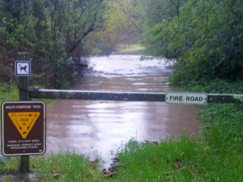
fire road and crossing at Andrew Molera 3/24/11 br Rain Greenslate

fishing regs sign at AMSP main crossing, 3/24/11 by Rain Greenslate

Flash Flood Warning

AT 5:27 pm THIS EVENING THE NWS ISSUED A FLASH FLOOD WARNING FOR THE BIG SUR RIVER. THE RIVER IS AT 9.25 FT AND FLOOD STAGE IS CONSIDERED 10 FT. WITH MORE SHOWERS EXPECTED, IT IS LIKELY THE RIVER WILL REACH FLOOD STAGE BEFIRE IT BEGINS TO RECEDE.

PLEASE NOTIFY ALL AFFECTED PERSONNEL AND TAKE NECESSARY PRECAUTIONS.

Sidney Reade

Monterey County OES

796-1902
———————————————–
Reports from locals indicate that the river is flowing quite fast and carrying some rather astonishingly large trees. One friend near the river has evacuated, others are keeping an eye out on the levels. Fortunately, many k-rails from the winter of 2008 are still in place. BE SAFE!!

LIMEKILN SLIDE PHOTOS

Hello everyone.  Avis here at Lucia. Been a crazy day today trying to get all the people trapped between the road closures to a safe place for the night.  And giving them a safe, dry place to hang out until we were sure they could not get through today. When I left work we had almost a full house and had made phone calls and arrangements for people to stay at different locations on the north coast. So thank you to everyone who worked with me today and helped to get these people to a safe location.

Officer Ben, thanks for stopping in to see us today. It was nice to see you and I hope you made it home safe and sound. Please leave a comment and let us know you’re okay.

I handed my camera to one of the bridge workers and asked if he had time to snap a few pics so everyone could see what the slide looks like. Below are those shots.

This first shot shows the roof of the loader working on the south side of the slide. This was the loader that got damaged. The windows were broken by rocks and the loader is out of commission for the moment but repairable. The operator is fine…thank goodness. He had a bloody nose and a cut on his forehead.

You can see how dangerous this is for the workers. Working on an active slide with large rocks falling. You can see the roof of the loader on the south side of slide.


Limekiln slide looking south
Working hard trying to open a lane

Thanks again to everyone who kept us informed on the situation. To all of the road warriors who worked so hard today in the wind, rain & falling rock. You are so brave and we appreciate you all. To all the other businesses I worked with on the phone today. And to the entire staff at Lucia. Everyone worked hard at making the stranded motorist feel safe, we fed them good food and offered warm safe rooms for them to stay at tonight.

Slide Near Limekiln

5:00 pm – got an update from the Big Sur Health Center for all of us:

Big Sur Health Center update:

As always, the Big Sur community has 24-hour access to a physician on-call through the Big Sur Health Center.

During the road closure, our regular office hours of Monday-Friday, 10:00 – 1:00 and 2:00 to 5:00 will remain in effect; however, we have extended our services to accommodate urgent medical needs during hours when we are closed.

For clarification, we have changed our answering service message and that should be in place later tonight.

In the meantime, if you have a true medical emergency, please call 911.

If you have an urgent matter that can’t wait until the next business day, please call the health center and listen to the entire message. You will be put in contact with the MD on-call. That person will assess your need and either offer advice or call local health center personnel to make arrangements for you to be seen at the Big Sur Health Center.

The weather and road conditions have created an enormous staffing challenge for us and we are attempting to meet your needs as efficiently as possible. Please try to be patient, use emergency services judiciously, and most of all, be safe.

3:20 pm – Big Sur Valley is reporting no power. There are 2 P.G. and E workers between the slides, so hopefully, power can be reinstated, but just in case it can’t – find your candles, flashlights, batteries, and lanterns. Buy ice, if you can. Oh, and keep those freezers closed. It will help keep the food from unthawing any sooner than necessary.

My thoughts, and those of my readers outside the Valley are with you all. Be safe tonight, please.

2:40 pm – Per CHP website:

2:39PM ATTN SLO COMM: REQ BEAT UNITS BE MADE AWARE OF THIS CLOSURE, AND ANTICIPATED OPENING OF 1 LN AROUND DUSK FOR CALTRANS, EMERGENCY VEHS, AND CONSTRUCTION ONLY

2:00 pm – official word is that work has ceased for the day at the operation at Limekiln due to safety concerns. One Windor loader was damaged, although the operator was not injured. The slide will be reassessed first thing tomorrow morning. Hunker down, it is not worth someone’s life, and don’t forget the operator we lost in the big slide of 1983. We do not want a repeat.

Noon – Official word from Colin Jones, CT is that this slide will NOT be open all day. Hoping to have it cleared by dark, but LOTS of material is falling on the road plus precarious large rocks that need to be brought down. Confirmed that the slide is SOUTH of Limekiln and that the Los Padres sign is buried in rubble.

Chimney Slide at Limekiln, 3/24/11 photo courtesy of Cal-Trans

11:30, from Avis about an hour ago: “Road closure near Limekiln State Park. I just got done speaking with officer Ben Grasmuck with the CHP, in fact he is standing here now. Best case scenerio for road opening (at least one lane) is 4 hours and possably 8 hours. Ben said he would instruct the CHP office to call us at Lucia when they get the road open.”

10 am – Sorry, it took longer than usual to get gennie going due to rain. Confirmed that the road is closed south of Limekiln at a place called “The Chimney. One report is that it will be open around 1 pm, another report is that it will take most of the day to open. The official word from Cal-Trans is 1 pm. Re-open is completely dependent on weather, of course, and heaviest rains expected between 11 and 2. This slide is north of N-F Rd. by a couple miles (slide at 20.5, and N-F at 18.9), so Big Sur is effectively an island for the moment.

BIG SUR MILE MARKERS ARE ALWAYS LINKED TO THE RIGHT, CURRENTLY UNDER THE LA NINA 2010-2011 SECTION. DURING FIRES, IT IS STILL THERE, JUST SHIFTED TO THE FIRE SEASON. REDTAIL HAS A VERY GOOD, DETAILED LISTING AND THAT IS THE ONE I USE.

I am getting gas delivered today, if my road is passable, so should be good until Monday. I’ll try to get going earlier tomorrow morning. It has just been nine days of pretty much non-stop reporting now, and like some of you, I am getting tired.

HAZARDOUS WEATHER OUTLOOK

Up here, heavy hail, sleet, rain, slush, whatever it is, it is nasty. I’ll insert a photo of my window here:

Back door, 3/23/11

but first, here is an announcement from the Office of Emergency Services!

From the Monterey County Office of Emergency Services

HAZARDOUS WEATHER OUTLOOK FOR MONTEREY COUNTY

MARCH 23, 2011

1. Over the past few days Monterey County has experienced periods of heavy rain, high winds and high surf. As a result the upcoming weather system, expected to arrive in Monterey County early Thursday, March 24, 2011 will result in the issuance of several weather statements. A High Wind Advisory will be in effect from 1100 hours until 2200 hours and will be in effect for the entire coast, moving inland to the ridgelines as the day progresses. Sustained winds will reach 25-35 MPH with gusts 45 MPH, and may be even stronger over the hills. Due to the already saturated ground conditions, hazards such as downed trees and power lines may be expected. An Urban Small Stream Flooding Advisory will be in effect from daybreak, approximately 0700 hours with 2” – 2 ½” of intense rainfall expected with this weather system. Flooding in low lying areas, small streams and creeks is possible.

2. The major rivers within Monterey County are being monitored by the Monterey County Water Resources Agency and public safety agencies and are currently below flood monitoring stage at this time with the exception of the Salinas River in Soledad at the Highway 101 Bridge area, where it is expected to crest at 20’ at midnight tonight. If you are in the area you are advised to follow the advice of public safety officials, and if at all possible, stay out of the area all together.

3. The weather system will have periods of heavy downpours and there is a chance of thunderstorms throughout the day. Due to the ground saturation and strong winds in the Santa Lucia Mountains mud/debris slides are also possible.

4. Stay aware of your local conditions, drive with extreme caution and follow the instructions of your local public safety officials. Be prepared should power outages occur. Watch for weather updates.

DAVID L. KRAUSS
INTERIM EMERGENCY SERVICES MANAGER

I have a photo of the funnel out over the ocean today that Kirsty Sullivan sent me to share (THANK YOU KITSTY!), but I haven’t been able to download the whole thing. I’ve asked for smaller copies.

Report on meeting with Cal-Trans about closure

Today, members of the community, and various agencies met over the Rocky Creek Closure, and this is what was discussed:

CHP will be on site 24/7 starting today so no foot traffic until further notice. There will be another meeting on the 29th at 1:00 p.m. and a decision on foot traffic will be made then.

Road issues – Steve B (not Steve Price) is now the project manager and reports directly to Steve Price. He said that rain will not stop work. He also said that the slide is on an ancient slide site and they are going to try to stabilize what’s left and build from there. They are going to start drilling a nail wall on the 24th and they have two drill rigs working. Butch Kronlund asked why they couldn’t cut into the east side of the hill and Steve said that it wouldn’t be prudent because of this being an ancient slide site. Cal Trans wants to have pedestrian traffic as soon as they think that it’s safe. Two crews will be working daylight hours when they are drilling the vertical soil nails and double shifts will be working when they drill horizontal soil nails. AMR cannot walk patients across or gurney them across until it is safe. All nails need to be installed before they will allow any foot traffic. They have 250 soil nails that need to be drilled. Cal Trans wants to get this project done in a safe and timely manner and they are very committed to this.

Cal Trans is also talking long term solutions. Steve said that a lot of studies and research need to be done. Some of the alternatives that were mentioned was a large scale wall (probably not) a viaduct which would be substantial in length or a permanent bridge.

So, there you have it. As up-to-date as I can make it.

Slide at or south of Gorda?

3:00 pm – just got a report from a local who went through the slide. It is, as I suspected, at Mud Creek. It is active, Cal-Trans is working it, and they do have one lane open at this time.

This is what is posted on the CHP website. Gorda says not there, so I suspect it is the infamous Mud Creek a mile or so south. That is the area I posted the photos of from last night, and the area I have been covering for the entire winter – actually, back to last year some time.

2:04PM 1039 TEMPLETON CHP OFFICE
2:04PM 1039 CALTRANS DIST 5
2:02PM 1039 SAN LUIS
2:00PM LINE 1 WAS GIVEN TO MTY COM FROM MIDCOAST FIRE BRIGADE
2:00PM SLIDE 1125 SB LANE

Weather/Road Reports, 3/23/11

1:00 pm – This update just received from Cal-Trans. (Ed. note: the contractor awarded the temporary repair is the same one working on the permanent repair down at Dani Creek near Lucia, a similar slip out.)
(1) Due to severe roadway damage to the southbound lane, a 2-mile section of Hwy. 1 at Rocky Creek (Post Mile
60.5) continues to be closed in both directions. The closure is north of Big Sur from the Bixby Creek Bridge to Palo Colorado Road, south of Carmel. This barricaded closure is for all travel including emergency vehicles, pedestrians and cyclists.

• Crews assessing the roadway have tentatively determined that, at the earliest, it will be nearly one month for a temporary repair to occur. Inclement weather and geologic instability continue to be a factor in roadwork progress.
• Condon Johnson & Associates of Oakland is the contractor for this $2.5 million emergency project and is currently mobilizing for the temporary repair. Drill rigs are on site and getting assembled while material for drilling vertical and horizontal soil nails in order to stabilize the remaining roadway section are arriving. This site is an active construction and the slope is still unstable so the roadway is unsafe for public access.
• All businesses along the coast on Hwy. 1 remain open directly and are directly accessible from the south. For access from the north, alternate routes include Highways 101, 68 and 46.
• More rain is expected in the Monterey Bay Area through the weekend.
• CHP is on site to secure the slide area and ensure safety for the public.
• Continuous updates will be provided as more information becomes available and/or conditions change.

I don’t repeat rumors (and there are a few of those flying as our isolation extends) , but I did hear from a reliable source that one or more locals created some problems at the closure yesterday. Let’s be part of the solution, not part of the problem.

11:30 am – there is a report of a slide at the bottom of Nacimiento-Fergusson Rd. However, it is possible to get past it at this time.

11:00 am – short but intense hail storm. Have received numerous reports that the road between Cambria and Big Sur is hanging tough, thanks to a wonderful Cal-Trans crew. Several people report making it through with no major difficulties.

9:30 am – I slept in after the storm kept me up much of the night. I woke to banshee winds around 2 am, and couldn’t get back to sleep until my my bed stopped rocking and rolling. It was howling! My son sent me some shots of the road south last night, so I’ll post those now. There are three of them. Pretty knarly out there!

**FLASH FLOOD WATCH***

Lots of emails to check and news to post but here are the photos taken this morning on the south end of our road.

Mud Creek or Alder Creek area, 3/23/11, by Brendon Shave

North Bound lane, 3/23/11, by Brendon Shave

Center of Highway, looking South, 3/23/11, by Brendon Shave

Okay, that’s it for this morning’s photos. I am getting a few questions and it is much easier to answer them here, so all will know, rather than individually. Friend came over Nacimiento-Fergusson Rd this morning through base, all quiet and cleared, so that route is good. As to number to call for Cal-Trans re getting a foot path open, I would suggest the PIO Colin Jones. 805-549-3189. While I used to have (and may still) Steve Price’s number, a) I can’t find it, and b) I’m not authorized to give it out. Lastly, have heard nothing re road to the south, which is good news.

NOAA discussion: “AS OF 9:02 AM PDT WEDNESDAY…A FRONT HAS PASSED OVER THE FORECAST AREA THIS MORNING AND RESULTED IN PERIODS OF HIGH WIND AND MODERATE TO HEAVY RAIN. MANY RIVERS AND STREAMS DID RESPOND TO THIS RAIN BUT REMAIN WELL BELOW FLOOD STAGE. … THE LARGEST THREAT FROM THESE STORMS
WILL BE SCATTERED MODERATE TO HEAVY SHOWERS THROUGHOUT THE DAY TODAY. THESE SCATTERED MODERATE TO HEAVY SHOWERS WILL RESULT IN ADDITIONAL PONDING ON THE ROADS AND PERIODS OF RISES IN THE RIVERS AND STREAMS.

MODEL SOLUTIONS ARE INDICATING THAT A LOW PRESSURE SYSTEM
CURRENTLY LOCATED IN THE GULF OF ALASKA WILL RAPIDLY SLIDE
SOUTHEAST INTO NORTHERN CALIFORNIA THURSDAY EVENING. A SIGNIFICANT JET MAX…110 TO 120 KT…WILL ACCOMPANY THE SURFACE FRONT AND PRODUCE ANOTHER ROUND OF SHOWERS AND THUNDERSTORMS FOR THE NORTHERN AND CENTRAL CALIFORNIA COAST. SOME OF THE SHOWERS WILL BE HEAVY AT TIMES. AFTER THE PAST FEW DAYS THE SOIL IS QUITE SATURATED AND RIVERS AND STREAMS WILL SEE A RAPID RESPONSE TO ANY ADDITIONAL PRECIPITATION.”

Let’s stay safe today!

Evening updates, 3/22/11

9 pm – it has been a long, interesting day. I am signing off for the evening, and will be back as soon as I have my coffee, get the gennie started, and get my day started in the am. Not going to be early, I don’t think. I’m getting a little tired. I’ve lost track, but I think it has been a week tomorrow. It started raining about an hour ago, but so far, relatively gentle, but now the wind is picking up. Great. Good night.

First, Pacific Valley School schedule for Weds. 3/23:

I’m forwarding the weather advisory that was emailed to us by Ron Eastwood at the Monterey County Office of Education. As a result of his email Raeanna at Pacific Valley School has decided to start school at
10:00 a.m. and be dismissed at 3:00 p.m. This is a safety measure to insure students and staff can arrive safely. If you feel as though the weather conditions are not safe we will certainly understand if you do not send your child to school. Some students have been sent home with home study packets so they should be continuing ahead on them. Since we’ll be starting at 10:00 we will not be serving breakfast but will serve lunch at 12:15 – 12:30 p.m.

Bus Times are: Morning Glory pick up at 9:15 a.m
Lucia pick up at 9:20ish a.m.
Cal Trans pick up at 9:50ish a.m.

Please adjust the afternoon drop off time with the bus leaving PV at 3:00 p.m. and heading south first then going to Lucia/Morning Glory.
Thank you for bearing with us during these winter storms.

Lisa Gering
**********************************************************************
Second, a flash flood watch has been issued. THE NATIONAL WEATHER SERVICE HAS ISSUED A FLASH FLOOD WATCH .. LOS PADRES NATIONAL FOREST AND SOUTHERN MONTEREY BAY AND BIG SUR COAST.

THIS IS IN EFFECT FROM MIDNIGHT TONIGHT THROUGH WEDNESDAY AFTERNOON.
*********************************************************************
And here is the “good” news (kate being facetious)
SATL IMAGERY IS INDC THAT THE SYSTEM OFF THE CENTRAL CA COAST (NEAR 37/129) IS MOVING ENE AT THIS TIME…AND IS INTENSIFYING.

MODELS BEGIN THE RAIN THIS EVENING…WITH THE RAIN BECOMING MODERATE…OR EVEN HEAVY AT TIMES OVERNIGHT INTO WEDNESDAY MORNING. EVEN THROUGH THE TPW`S ARE LESS THAN ONE INCH…THERE IS STRONG ISENTROPIC LIFT…WHICH IS PERPENDICULAR TO THE COASTAL MOUNTAINS. THEREFORE…RAINFALL RATES COULD BECOME EXCESSIVE. THEREFORE…A FLASH FLOOD WATCH HAS BEEN ISSUED FOR THE COAST AND COASTAL MOUNTAINS FOR LATE TONIGHT AND WEDNESDAY (ALSO INCLUDING THE NORTHERN SALINAS VALLEY). WINDS WILL BECOME GUSTY TONIGHT…BUT SHOULD REMAIN BELOW ADVISORY LEVELS. NEVERTHELESS…DOWNED TREES AND POWER LINES… ESPECIALLY IN THE MOUNTAINS WITH THE SATURATED SOILS ARE VERY POSSIBLE. THE NAM12 IS INDC A DECENT AMOUNT OF INSTABILITY WED AFTN AND EVENING…SO HAVE ADDED THUNDER TO THE FORECAST ACROSS THE DISTRICT.

RIGHT ON THIS SYSTEMS HEELS WILL BE THE NEXT UPSTREAM SYSTEM WILL BRING WARM ADVECTION RAINS STARTING WEDNESDAY NIGHT. THIS SYSTEM COULD EVEN BE STRONGER THAN THE SYSTEM TONIGHT/WEDNESDAY. RAINFALL COULD BE EXCESSIVE AT TIMES…SO IT WOULD NOT BE A SURPRISE IF ANOTHER FLASH FLOOD WATCH IS ISSUED. WINDS WILL BE GUSTY WITH DOWNED TREES AND POWER LINES ONCE AGAIN.