7 pm – a look at the VETS infrared from this afternoon, comparing it to previous, reading what I can find, my confidence level is not as high as it was earlier today. Primarily that is due to the VETS infrared. There is still an active line in Div CC with no dozer line in front of it. Anastasia is still active. The skies have been smokey this afternoon, but by no means as smokey as previous days. I do NOT feel there is imminent threat to either Arroyo Seco or Tassajara tonight, I am just saying it is not over, yet. Here is the map I was looking at:

“#SoberanesFire Taped live at the September 24th, 2016 community meeting in Arroyo Seco, Cal 4 Incident Commander Rocky Opliger announces a major change in firefighting tactics. Instead of utilizing strategic firing operations to secure the threatened residences in Arroyo Seco, firefighters will take the opportunity to build direct fire line around the existing fire which is 2 miles north. In addition to being the correct tactic based on current and expected weather and fuels conditions, leaving the vegetation in the watersheds above Arroyo Seco unburnt will result in a significant decrease in erosion. Additionally, strategic firing operations would have resulted in a mandatory evacuation order for numerous residences.”
For those who don’t do FB, here is a link to Vimeo:
New tactics
From Pacific Valley School:

Daily Update: September 25, 2016
Current Size: 126,693 acres (89,499 acres Los Padres National Forest; 37,194 acres CAL FIRE)
Containment: 77% Personnel: 2,072 Cause: Illegal campfire Injuries: 1 fatality, 8 injuries
Structures Destroyed:
57 homes, 11 outbuildings
Structures Threatened: 410
Crews: 42
Engines: 97
Helicopters: 22
Dozers: 16
Masticators: 4
Water Tenders: 15
Current Situation:
After evaluating weather and fire conditions, the Soberanes Fire incident management team has made the decision to go direct. Barring unexpected events, there will be no burnouts in the Arroyo Seco area. Recent days of favorable weather, including increases in relative humidity, have created conditions that allow firefighters to engage closer to the fireline.
Direct attack on a fire means constructing a containment line directly on the fire perimeter. The advantages:
· Minimal area is burned; no additional area is intentionally burned
· It is often the safest tactic because firefighters can usually escape into the burned area
· The uncertainties of firing operations can be reduced or eliminated
The disadvantages:
· Firefighters can be hampered by heat, smoke and flames
· Control lines can be long and irregular
· Burning material can easily spread across mid-slope lines
· Can only be initiated when escapes routes and safety zones are available
· More mop-up and patrol is usually required
On Saturday, crews maintained and improved the line around the Chews Ridge spot fire and will continue to do mop-up today. Crews also will continue to mop up the spot fire near Arroyo Seco.
The most active fire area is near Church Ranch, west of Tassajara Road. On Saturday, aircraft worked to cool the area. Firefighters are prepared to protect the Tassajara Zen Center in the event fire reaches that area.
Incident management staff participated in a well-attended public meeting on Saturday at Arroyo Seco.
Evacuation orders and warnings remain in effect in the eastern areas of the fire. Information on evacuations is available at http://inciweb.nwcg.gov/incident/4888 (click on the Announcements tab).
For more information, visit: http://inciweb.nwcg.gov/incident/4888/ or follow us at http://www.facebook.com/LosPadresNationalForest or http://www.twitter.com/LosPadresNF.
Other contacts: SPCA, (831) 646-5534; American Red Cross, (866) 272-2237.
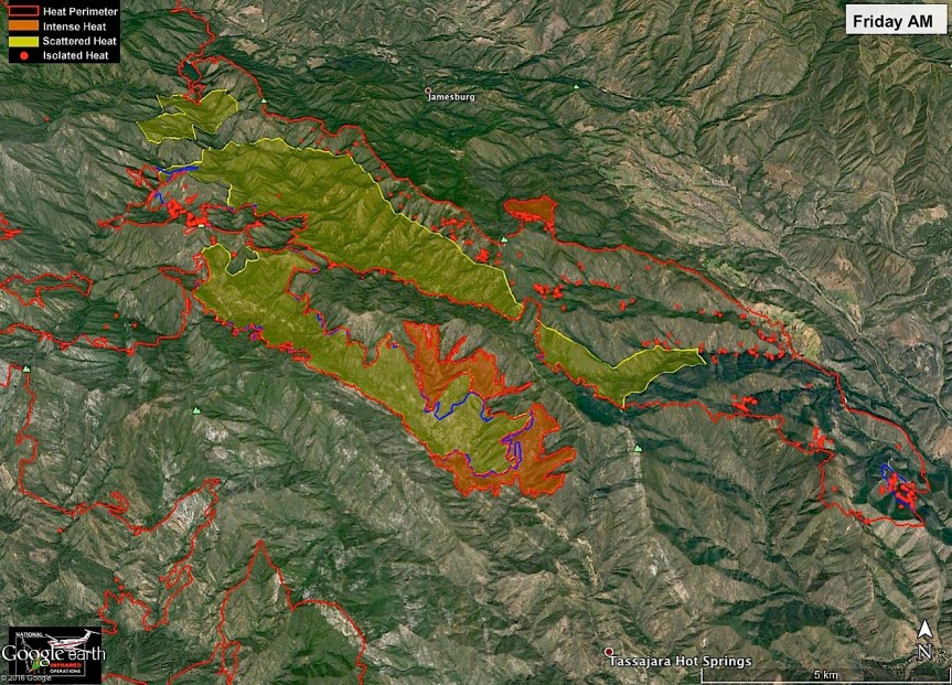
John Chesnut map:

6:30 am – Containment is looking good based on today’s IR Map, only lost 65 acres since the last map.

IR Topo Map in PDF

Briefing Map in PDF
Weather predictions and fire behavior discussions:


Like this:
Like Loading...