

Check out this amazing drone video of #Hwy1 washout at Rat Creek about 15 miles south of #BigSur. Our crews are on site securing it, assessing damage & starting clean-up/ repairs. Reminder: the road is OPEN from #Carmel thru town of Big Sur. @bigsurkate @BigSurCC @CHP_Coastal pic.twitter.com/rB193DzXhL
— Caltrans District 5 (@CaltransD5) January 29, 2021
Tag: road conditions
Annnddd…another one – Film shoot for Weds at Bixby
At least this one is making a donation to the Mid-Coast Fire Brigade for our troubles, but still…
Good morning!
I am reaching out to all of you to advise of an upcoming TV commercial filming project on Hwy 1 / Bixby Bridge.
We have been working closely with the California Film Commission, the Monterey County Film Commission, CalTrans,The California Highway Patrol, the County of Monterey, The Monterey County Sheriffs Department, and the Monterey Bay National Marine Sanctuary on obtaining all the needed permits for a one day shoot on October 3rd at the Bixby Bridge.
I have attached a notification form below that details the specifics of the project, but basically it will be a single afternoon of filming on October 3rd.
We will have 4 CHP officers on scene to assist with safety and limited duration traffic control.
There will be filming of a motorcycle driving across the bridge from a camera car, and from static camera positions both on Hwy 1 and on Old Coast Road. There will also be a couple shots with a small drone (FAA licensed and not flying over the water). The craft is quite small and quiet.
There will be a small section of the south side of Old Coast Road just to the east of Hwy 1 posted for no parking during the shoot.
We are very sensitive to, and aware of the very busy nature of the location and will insure that delays are kept to a minimum and that residents and visitors will be able to get into the area with delays not exceeding 3-5 minutes at a time. And since school buses come through that area in the afternoon we will always release traffic when we see a school bus approaching.
Our main base camp and parking area will be on private property off site – south of the bridge – so as to minimize impact on the immediate area.
In consideration of the project, and as a gesture to the community, we are going to be making a donation to the Mid-Coast Fire Brigade.
Thank you for your understanding – we hope to make our short time at the Bixby Bridge a smooth experience for all!
all the best,
Film Shoot Notice for Monday

Photo Sunday, 9/23/18
I happened to get behind this just south of Cambria. When he didn’t turn in at the Windsor yard, I knew he was heading up to Mud Creek. The truck driver knows me, so when we had to stop for construction, he came back and told me this was a 12 TON boulder he was carrying. Hope it helps!


Sink Hole starting at Rocky Creek, 5/9/18
This is from the CHP website, I have no additional information at this time:
ent: 00152 Type: Traffic Hazard Location: SR1 N / ROCKY CREEK Loc Desc: NB JNO Lat/Lon: 36.378889 -121.902500
| Detail Information | |||||||
| 10:55 AM | 4 | [10] 1039 DOT | |||||
| 10:48 AM | 3 | [5] 1/4 MILE JNO ROCKY CREEK BRDG | |||||
| 10:47 AM | 2 | [2] 1/4 MILE BRIDGE NR 55 MPH SIGN | |||||
| 10:46 AM | 1 | [1] SINK HOLE STARTING NR ROCKY CREEK BRIDGE | |||||
| Unit Information | |||||||
Photo Sunday – Grey Slip, 2002, 5/6/18
Copyright (C) 2002-2018 Kenneth & Gabrielle Adelman, California Coastal Records Project, www.Californiacoastline.org Used with permission.
Thanks to Barbara for finding this for me.

Mud Creek Contract and other oddities, 5/5/18
Yesterday, I finally had the time to go through the Mud Creek contract first awarded to Madonna Construction on 1/19/17. I’ve pulled out a few bits of information, took some screen shots, sent off emails to Cal Trans for comments, and otherwise started research and analysis. There is still much to discover and understand, but given that no one at Cal Trans has thus far responded, I decided to publish what I have today.
The original contract provided for removing slide material, installing rock nets, and restoring facilities to enable reopening the highway. This contract was awarded 1/19/17 and signed 3/17/17. It was for 30 days at a cost of $2,500,000. It is a public works contract specifically excluded from 2 CCR § 547.59. (California Code of Regulations.) It is exempt from public bidding as explained in the State Contracts Manual (SCM) §5.80 (A)(3) which states: “As noted in section 5.05, competitive bidding is required unless there is a legally authorized basis for bid exemption. Key exemption categories are identified below. A. Statutory Exemptions: 3. Emergency contracts. The work or service is for the immediate preservation of the public health, welfare, safety, or protection of State property (PCC §§ 1102, 10340).”
On 4/6/17, the original contract was modified to increase the contract from $2,500,000 to $9,500,000 an increase of 3 and 1/2 times the original amount and added 80 days for completion, for a total of 110 days. After the BIG slide on 5/19/17, The Contract was again modified two months later on 7/18/17 to $12,000,000 and another 60 days was added to the contract for a total of 170 days. Two more modifications, one on 9/20/17 for an additional amount of $32,000,000 and an addition of 150 WORKING days (30 weeks) for a total of 320 days, and another on 9/18/17 of total amount of $56,000,000 (previously awarded, PLUS the requested additional $32,000,000) would then take the contract to the end of April 2018.

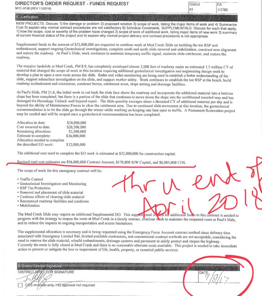
By my calculations, the time and the $56,000,000 award ran out on 4/18/18 although the first page reproduced above says “end of April” so the contract has been renewed or is in the process of being renewed. I asked for the extension on this contract, but have yet to receive it. I will discuss it when received and will follow-up on that next week.
Besides the contract itself, I also inquired about the excavation going on at Grey Slip, a few miles south of Mud Creek, to obtain fill material. Grey Slip is another area of prior road issues. I asked Cal Trans to comment on this yesterday, but so far have not received any response. One local was told that they had originally started excavation on the west side, but after some movement, moved to the east. I have not been able to confirm this, as Cal Trans did not respond to my questions. I looked through some of my photographs to see if I could find an older one to show any prior issues at this point, but haven’t been able to locate one. Rock Knocker put all his old photos in a storage unit in Paso/Templeton, so no help there. If anyone else has a photo of Grey Slip in prior years, I would love to see it.
This is what is happening at Grey Slip currently:


Highway Closure Update, 4/24/18
Photos (1-2) of Mud Creek (PM 8.9) from Friday, April 20; (3-5) of the Coastlands (PM 44.41) south of PCB taken Friday, April 20, pictures of “Geo Web” before and after being covered up by soil—it helps stabilize the slope.


HIGHWAY 1 UPDATE – Tuesday, April 24
State Route 1 in Monterey County remains closed from north of Salmon Creek, just south of the Ranger Station (PM 3) to just south of Gorda (PM 10) due to the Mud Creek slide. State Route 1 south of Salmon Creek is accessible via State Route 1 in San Luis Obispo County near Ragged Point.
REMINDER: Travelers still CANNOT access the entire length of Highway 1 from Carmel to Cambria but local businesses are open on both sides of Mud Creek.
Mud Creek (PM 8.9)
Mud Creek had a major slide on Saturday, May 20, 2017, losing over 5 million cubic yards of material. Caltrans continues with its plan to realign the existing terrain with the projected timeline to safely open to public traffic is late-summer 2018 at an estimated cost of $40 million. A more specific opening schedule will be announced in next week’s update.
This week: Work continues on the north cut, middle and north fills, and on north berm.
There is currently no public/local access through the Mud Creek area since this remains an active, emergency construction zone.
Paul’s Slide (PM 21.6)
Paul’s Slide was cleaned up last week from debris and slide material. It is still active but the 24/7traffic signal remains in place and temporary guardrail (k-rail) in the centerline.
ADDITIONAL WORK—CALPORTLAND PAVING BETWEEN LUCIA (PM 23) AND JUST SOUTH OF PCB (45.52)
Final items continue taking place. Metal Beam Guardrail (MBGR) end treatment work at Castro Canyon (PM 43.12) and slope work at the Coastlands (PM 44.41) is taking place. Last week Geo Web was installed to help stabilize the slope (see pix above). This week we are adding recessed marker to the striping.
Caltrans reminds motorists to move over and slow down when driving through highway work zones.
The next update will be on Monday, April 30 ☺
Susana Z. Cruz
Caltrans District 5
Public Information Officer
Rain & Road, 2/2/17
9:46 am – closure back in place at Ragged Point on the south end.
9:46 AM 8 [10] 27-N24 OPEN F/RAGGED PT TO LIMEKILN / CLOSURE BACK IN PLACE @ RAGGED PT [Shared]
8:30 am – Consistent with what Cal Trans put out last night – From the CHP log:
6:10 AM 5 [5] OVERNIGHT CLOSURES **SR1 WILL REMAIN CLOSED OVERNIGHT FRM RAGGED POINT (SLO MM 72.87) TO DLOAN POINT (MONT MM 29.70) AND ALSO WILL REMAIN CLOSED IF IT IS RAINING DUE TO THE INSTABILITY OF THE ROCK/MUD SLIDES.
Rain down here 1.38″ at Anderson Peak and 1.5″ at Three Peaks. NOAA says: “Wet start to the year looks to stay in place at least through mid-month.” Rain on and off throughout the day, with another system coming in tonight through Friday, then a bit of a break on Saturday, and another system Sun-Mon.
(this post will be updated throughout the day as needed, but new post with CT update, when received.)
A couple slide photos by DMT
Taken yesterday by Michael Troutman. Top to Bottom: Paul’s Slide, Cow Cliff, Anderson.
Also, scaling will be taking place today at Cow Cliff’s, but will make time and space for locals to get through, when possible. Unsure re Anderson, yet.


